Location
Latitude: |
43-06-07.4000N (43.102056) |
Longitude: |
094-42-16.3000W (-94.704528) |
Elevation: |
1206.1 feet MSL (368 m MSL) |
Magnetic Variation: |
1.2 E (as of April 2024 from WMM2020 model) |
Time Zone: |
UTC -6.0 (Standard Time) UTC -5.0 (Daylight Savings Time) |
From City: |
01 N.M. SW of Emmetsburg, Iowa |
Found On: |
Omaha Chart |
FAA Region: |
ACE |
Contacts
Manager: |
Publicly owned: |
| KIMBERLY KIBBIE 3775 450TH STREET EMMETSBURG, IA 50536 712-852-4030 |
CITY OF EMMETSBURG 2021 MAIN EMMETSBURG, IA 50536 712-852-4030 |
Operations
Airport Status: |
Operational |
Facility Use: |
Public |
Type: |
Airport |
Activation Date: |
03/1945 |
Control tower: |
No |
Attendance (Months/Days/Hours): |
Months/Days/Hours ALL/ALL/IRREGULAR |
Boundary ARTCC: |
ZMP (Minneapolis) |
Responsible ARTCC: |
ZMP (Minneapolis) |
Lighting Schedule: |
SEE RMK |
Segmented Circle Indicator: |
No |
Traffic Pattern Altitude (MSL): |
2206 feet (672 m) |
NOTAMs Facility: |
FOD |
NOTAM-D Service: |
Yes |
International Airport of Entry: |
No |
Customs Landing Rights: |
No |
Military Landing Rights: |
Yes |
Civil/Military Joint Use: |
No |
Based Aircraft
| Single Engine: | 11 |
| Multi Engine: | 1 |
Annual Operations (as of 07/16/2020)
| Total Operations: | 2500 | |
| GA Local: | 2254 | 90.2% |
| GA Itinerant: | 246 | 9.8% |
Communications
| CTAF: | 122.800 |
| Unicom: | 122.800 |
- APCH/DEP SVC PRVDD BY MINNEAPOLIS ARTCC ON FREQS 127.75/257.7 (FAIRMONT RCAG).
Fixed Based Operators (FBOs) & Fuel
(Click on a business for detail)
Please help us keep this information up to date. This is a FREE SERVICE just like everything else on Airport Guide! If you see that a business needs to be added, modified, or deleted please fill out our Update Form.
To add, modify, or delete a business click here.
Please help us keep this information up to date. This is a FREE SERVICE just like everything else on Airport Guide! If you see that a business needs to be added, modified, or deleted please fill out our Update Form.
Area Code: 712 |
| Business Name | Frequency | Phone | Fuel Grade |
|---|---|---|---|
| Emmetsburg Flying Service
Update FBO info |
Unicom 122.8 | 852-3810 | 100LL, MOGAS |
Flight Service Stations
| Primary | Alternate | |
| FSS on Field: | N | |
| FSS Name (ID): | Fort Dodge(FOD) | |
| Frequency: | ||
| Toll Free Phone: | 1-800-WX-BRIEF |
Instrument Procedures / Charts
FAA Terminal Procedures valid from 0901Z 03/21/24 to 0901Z 04/18/24.
There are various types of charts available for an airport. They are listed in the Page Type column. Here is a legend for those types:
APD - Airport Diagram
DP - Departure Procedure Charts
HOT - Hot Spots
IAP - Instrument Approach Procedure Charts
MIN - Minimums
STAR - Standard Terminal Arrival Charts
| Page Type | Page Name | Volume | Action Since Last Cycle |
|---|---|---|---|
| IAP | RNAV (GPS) RWY 13 | NC-3 | |
| IAP | RNAV (GPS) RWY 31 | NC-3 | |
| MIN | TAKEOFF MINIMUMS | NC-3 |
Terminal Procedures are only available for airports in several countries with more being added all the time. If you are looking for a specific country's charts, please send an email to support(at)airportguide.com stating the country name. This will be used to prioritize the implementation.
Navigation Aids (Navaids) near KEGQ
| Dist (NM) | ID | Morse Code | Name | Type | Freq | True Hdg | Mag Hdg |
|---|---|---|---|---|---|---|---|
| 0.2 | EGQ | . _ _ . _ _ . _ | Emmetsburg | NDB | 410 | 243 | 242 |
| 15.0 | PUF | . _ _ . . . _ . . _ . | Puff | NDB | 345 | 354 | 353 |
| 18.5 | EST | . . . . _ | Estherville | VOR | 110.40 | 354 | 353 |
| 18.8 | LTU | . _ . . _ . . _ | Little Sioux | NDB | 326 | 274 | 273 |
| 19.0 | AXA | . _ _ . . _ . _ | Algona | NDB | 403 | 93 | 92 |
| 21.5 | POH | . _ _ . _ _ _ . . . . | Pocahontas | NDB | 428 | 173 | 172 |
| 22.0 | SPW | . . . . _ _ . . _ _ | Spencer | VOR-DME | 115.15 | 279 | 278 |
| 28.4 | SP | . . . . _ _ . | Snore | NDB | 394 | 286 | 285 |
| 32.9 | FQ | . . _ . _ _ . _ | Montz | NDB | 420 | 30 | 29 |
| 34.5 | FOD | . . _ . _ _ _ _ . . | Fort Dodge | TACAN | 113.50 | 148 | 147 |
| 34.6 | FNX | . . _ . _ . _ . . _ | Fairmont | DME | 114.25 | 21 | 20 |
| 34.9 | FRM | . . _ . . _ . _ _ | Fairmont | DME | 110.2 | 20 | 19 |
| 34.9 | MJQ | _ _ . _ _ _ _ _ . _ | Jackson | NDB-DME | 353 | 339 | 338 |
| 38.3 | SLB | . . . . _ . . _ . . . | Storm Lake | NDB | 434 | 218 | 217 |
| 39.4 | FO | . . _ . _ _ _ | Barro | NDB | 341 | 153 | 152 |
| 39.8 | SBU | . . . _ . . . . . _ | Blue Earth | NDB | 332 | 41 | 40 |
| 45.0 | SKI | . . . _ . _ . . | Sac City | NDB | 356 | 195 | 194 |
| 45.3 | OT | _ _ _ _ | Wondd | NDB | 277 | 313 | 312 |
| 46.7 | CAV | _ . _ . . _ . . . _ | Clarion | NDB | 387 | 116 | 115 |
| 48.1 | FXY | . . _ . _ . . _ _ . _ _ | Forest City | NDB | 359 | 80 | 79 |
Nearby Airports with Fuel
Notices to Airmen (NOTAMS)
Remarks
| A110-1 | FOR CD CTC MINNEAPOLIS ARTCC AT 651-463-5588. |
| A42-04 | 04/22 THRS & SIDES MARKED WITH YELLOW CONES. |
| A42-17 | 17/35 THLDS & SIDES MARKED WITH YELLOW CONES. |
| A52-04 | UNLIT CRANE |
| A81-APT | ACTVT MIRL RY 13/31, REIL & PAPI RYS 13 & 31 - CTAF. |
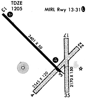
Runways
Runway Summary
| Runways: | 04/22 13/31 17/35 |
| Longest Runway: | 13/31 is 3401 ft (1037 m) long |
| Runways with an Instrument Approach: |
KEGQ Airport Runway Details
| Runway 04/22 | 2537 ft x 120 ft (773 m x 37 m) | |
| Runway Length Source: | 3RD PARTY SURVEY as of 08/09/2010 | |
| Surface: | Turf - Fair condition - No special surface treatment | |
Runway 04 |
Runway 22 |
|
Elevation: |
1201.6 | 1204.9 |
Latitude: |
43-05-53.0851N | 43-06-10.8679N |
Longitude: |
094-42-23.7939W | 094-41-59.6987W |
|
Runway True Alignment: |
045 | 225 |
Glide Path Angle: |
0.0 degrees | 0.0 degrees |
Object at End: |
ROAD | OTHER |
Object Height: |
11 | 70 |
Distance from End: |
230 | 893 |
Object Centerline Offset: |
0 ft. left and right of centerline | 350 ft. left of centerline |
| Runway 13/31 | 3401 ft x 60 ft (1037 m x 18 m) | |
| Runway Length Source: | 3RD PARTY SURVEY as of 08/09/2010 | |
| Surface: | Turf - Fair condition - No special surface treatment | |
| Runway Pavement Class: | 5 /R/C/W/U | |
| Runway Edge Lights: | Medium Intensity | |
Runway Weight Bearing Capacity (in thousands of pounds) |
||
| Single Wheel Landing Gear: | 29.0 | |
Runway 13 |
Runway 31 |
|
Elevation: |
1205.6 | 1205.1 |
Latitude: |
43-06-25.6696N | 43-06-01.2840N |
Longitude: |
094-42-42.1167W | 094-42-10.5890W |
|
Runway True Alignment: |
137 | 317 |
Glide Path Angle: |
4.0 degrees | 3.0 degrees |
Traffic Pattern: |
Left | Left |
Runway Markings Type: |
Nonprecision Instrument | Nonprecision Instrument |
Runway Markings Condition: |
Good | Good |
Object at End: |
TREES | TREE |
Object Height: |
55 | 62 |
Distance from End: |
434 | 1371 |
Object Centerline Offset: |
0 ft. left and right of centerline | 350 ft. left of centerline |
Visual Glide Slope Indicators: |
4-Light PAPI On Left Side Of Runway | 4-Light PAPI On Left Side Of Runway |
REIL: |
Yes | Yes |
Threshold Crossing Height: |
54 | 40 |
| Runway 17/35 | 2157 ft x 150 ft (657 m x 46 m) | |
| Runway Length Source: | 3RD PARTY SURVEY as of 08/09/2010 | |
| Surface: | Turf - Fair condition - No special surface treatment | |
Runway 17 |
Runway 35 |
|
Elevation: |
1203.5 | 1201.5 |
Latitude: |
43-06-14.8854N | 43-05-53.5800N |
Longitude: |
094-42-05.6831W | 094-42-05.8930W |
|
Runway True Alignment: |
180 | 000 |
Glide Path Angle: |
0.0 degrees | 0.0 degrees |
Object at End: |
TREE | TREE |
Object Height: |
36 | 45 |
Distance from End: |
565 | 341 |
Object Centerline Offset: |
0 ft. left and right of centerline | 350 ft. left of centerline |
Services
Airframe Repair: |
Major |
Powerplant Repair: |
Major |
Bottled Oxygen: |
None |
Bulk Oxygen: |
None |
Fuel Available: |
100LL, Jet A |
Landing Fees: |
No |
Parking: |
Hangars and tiedowns available |
Maps & Diagrams
KEGQ Sectional
Flight Planning
at skyvector.com
at skyvector.com