Wednesday 15 July 2026
UTC: 14:14:47 GMT (Zulu) Local:
UTC: 14:14:47 GMT (Zulu) Local:
Wednesday 15 July 2026
UTC: 14:14:47 GMT (Zulu)
Local:
Announcing the Airport Guide for Pilots iPhone App
Airport Guide's first iPhone App
"what airport has a paved runway at least 4000 feet long, above 3000 feet MSL, in the state of California, and between 100 and 150 miles of Los Angeles."
Only 1 public airport meets that criteria, Yucca Valley (L22)
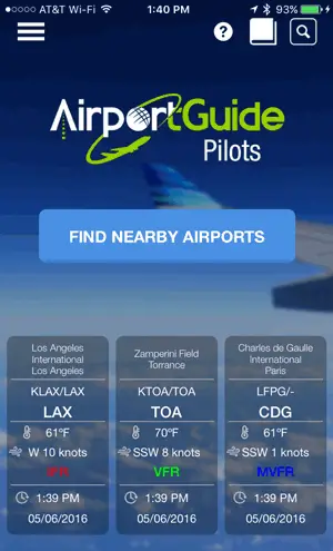
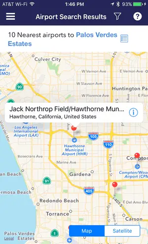
With Airport Guide for Pilots, you get the full AirportGuide.com database to search on the go with 47,000+ landing facilities. Most Airport Guide for Pilots features can be used offline so you can research the airport, perform E6B calculations with one of the many aviation calculators, and reference the aviation Book library. If you happen to be online, you can also use the handy Find Nearby Airports button on the home page to immediately show the nearest fields to your location using your GPS coordinates. As with all search results, this list can be filtered to show only public airports in case you are in the air and need to know your options to land quickly.
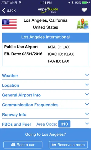
After performing a search, you can save any airports as a Favorite and it will show on the home page when you open the app to immediately tell you the latest weather (VFR, MVFR, IFR, LIFR). Select the airport and get key airport information such as the latest METAR, location, comm frequencies, runway info, FBOs, and fuel. You can even rate and review the airport to help your fellow pilots. If you have ever flown into an airport and needed a car or hotel, look no further than the booking links at the bottom of each airport screen to get you set up with lodging and transportation in no time.

APP FEATURES:
The three main areas in the Airport Guide for Pilots app are:
AIRPORT SEARCH
Get the full AirportGuide.com landing facility database including all public, private, and military airports, heliports, seaplane bases, STOLports, gliderports, balloonports, and ultralight fields throughout the world. Search the database using any of the following fields:
• Airport IDs - IATA ID, ICAO ID, Local ID (FAA, TC, etc.)
• Facility Use - public, private, military
• Facility Type - airport, balloonport, gliderport, heliport, seaplane base, ultralight
• Airport Name
• City
• State
• Country
• Minimum & Maximum Elevation
• Latitude and Longitude coordinates
• Runway length
• Paved runways
• Instrument approaches
• Minimum & Maximum distance from your location or airport of your choice
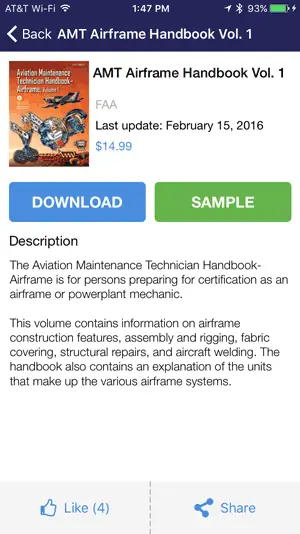
BOOK LIBRARY
Get the comprehensive library of FAA handbooks and Practical Test Standards through our Book Store. View samples and download books with an in-app purchase.
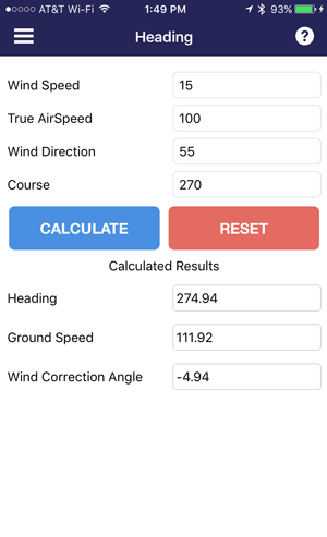
FLIGHT CALCULATORS
Use our E6B calculators to help you perform your flight planning tasks. If there is a calculator you would like to see included please let us know. The main categories are:
• Wind & Ground Speed
• Time/Distance Speed
• Temperature Calculations
• Density and Pressure
• Turning Performance
• Airport Distance and Heading calculator between any two airports
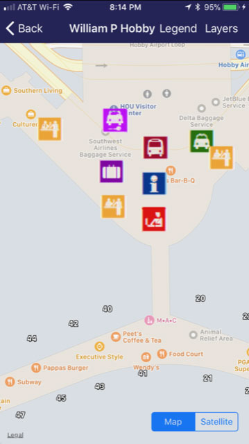
AIRPORT TERMINAL MAPS
The newest edition of the app includes airport terminal maps for over 375 airports (with in-app purchase). Use these maps to see your location within the airport and find your way to the next gate and restaurants. The maps include layers so you can change between map and satellite views as well as turn off the Terminal layer and see all of the businesses on the base Apple Maps. Go and experiment with the layers to see what I'm talking about.
SYSTEM REQUIREMENTS:
- iPhone, iPad, iPod Touch
- iOS 8.1 or higher
COST:
• Free with in-app purchases available for e-books
Data Disclosure
---------------------
The airport database used in this app is the same database used on AirportGuide.com and is constantly being updated. However, new database releases are usually made approximately every 4 weeks and will show as a database update within the app settings. The airport database has been evolving for more than 25 years with data from the FAA, DAFIF, and many international AIP sources. While we strive for perfection, the airport data changes quite frequently, and is not guaranteed to be 100% accurate at any given time. Airport Guide for Pilots is a very useful resource for pilots but please consult official data sources when planning your flight.
Feedback and Support
-------------------------------
We encourage feedback on any aspect of Airport Guide for Pilots from data issues to user interface issues to new suggestions. With your help, this app will only get better with time. Thanks!
The three main areas in the Airport Guide for Pilots app are:
AIRPORT SEARCH
Get the full AirportGuide.com landing facility database including all public, private, and military airports, heliports, seaplane bases, STOLports, gliderports, balloonports, and ultralight fields throughout the world. Search the database using any of the following fields:
• Airport IDs - IATA ID, ICAO ID, Local ID (FAA, TC, etc.)
• Facility Use - public, private, military
• Facility Type - airport, balloonport, gliderport, heliport, seaplane base, ultralight
• Airport Name
• City
• State
• Country
• Minimum & Maximum Elevation
• Latitude and Longitude coordinates
• Runway length
• Paved runways
• Instrument approaches
• Minimum & Maximum distance from your location or airport of your choice
BOOK LIBRARY
Get the comprehensive library of FAA handbooks and Practical Test Standards through our Book Store. View samples and download books with an in-app purchase.
FLIGHT CALCULATORS
Use our E6B calculators to help you perform your flight planning tasks. If there is a calculator you would like to see included please let us know. The main categories are:
• Wind & Ground Speed
• Time/Distance Speed
• Temperature Calculations
• Density and Pressure
• Turning Performance
• Airport Distance and Heading calculator between any two airports
AIRPORT TERMINAL MAPS
The newest edition of the app includes airport terminal maps for over 375 airports (with in-app purchase). Use these maps to see your location within the airport and find your way to the next gate and restaurants. The maps include layers so you can change between map and satellite views as well as turn off the Terminal layer and see all of the businesses on the base Apple Maps. Go and experiment with the layers to see what I'm talking about.
SYSTEM REQUIREMENTS:
- iPhone, iPad, iPod Touch
- iOS 8.1 or higher
COST:
• Free with in-app purchases available for e-books
Data Disclosure
---------------------
The airport database used in this app is the same database used on AirportGuide.com and is constantly being updated. However, new database releases are usually made approximately every 4 weeks and will show as a database update within the app settings. The airport database has been evolving for more than 25 years with data from the FAA, DAFIF, and many international AIP sources. While we strive for perfection, the airport data changes quite frequently, and is not guaranteed to be 100% accurate at any given time. Airport Guide for Pilots is a very useful resource for pilots but please consult official data sources when planning your flight.
Feedback and Support
-------------------------------
We encourage feedback on any aspect of Airport Guide for Pilots from data issues to user interface issues to new suggestions. With your help, this app will only get better with time. Thanks!