Location
Latitude: |
44-42-55.8000N (44.7155) |
Longitude: |
069-51-59.3000W (-69.866472) |
Elevation: |
270.2 feet MSL (82 m MSL) |
Magnetic Variation: |
15.1 W (as of April 2024 from WMM2020 model) |
Time Zone: |
UTC -5.0 (Standard Time) UTC -4.0 (Daylight Savings Time) |
From City: |
04 N.M. W of Norridgewock, Maine |
Found On: |
Montreal Chart |
FAA Region: |
ANE |
Contacts
Manager: |
Publicly owned: |
| RICHARD LABELLE PO BOX 7 NORRIDGEWOCK, ME 04957 207-634-2252 |
TOWN OF NORRIDGEWOCK PO BOX 7 NORRIDGEWOCK, ME 04957 207-634-2252 |
Operations
Airport Status: |
Operational |
Facility Use: |
Public |
Type: |
Airport |
Activation Date: |
02/1944 |
Control tower: |
No |
Attendance (Months/Days/Hours): |
Months/Days/Hours ALL/MON-FRI/0700-1400 |
Boundary ARTCC: |
ZBW (Boston) |
Responsible ARTCC: |
ZBW (Boston) |
Lighting Schedule: |
SEE RMK |
Segmented Circle Indicator: |
Yes |
Traffic Pattern Altitude (MSL): |
1270 feet (387 m) |
NOTAMs Facility: |
BGR |
NOTAM-D Service: |
Yes |
International Airport of Entry: |
No |
Customs Landing Rights: |
No |
Military Landing Rights: |
Yes |
Civil/Military Joint Use: |
No |
Based Aircraft
| Single Engine: | 27 |
| Ultralights: | 1 |
Annual Operations (as of 08/09/2022)
| Total Operations: | 9820 | |
| GA Local: | 6900 | 70.3% |
| GA Itinerant: | 2900 | 29.5% |
| Military Aircraft: | 20 | 0.2% |
Communications
| CTAF: | 122.800 |
| Unicom: | 122.800 |
| Approach: | PORTLAND 128.35 128.35 BOSTON ARTCC |
| Departure: | PORTLAND 128.35 128.35 BOSTON ARTCC |
| AWOS-AV: | 123.075 |
- APCH/DEP SVC PRVDD BY BOSTON ARTCC ON FREQS 128.2/263.05 (112-292) (WATERBORO RCAG); FREQS 124.25/290.50 (293-111) (BANGOR RCAG) WHEN PORTLAND APCH CTL CLSD.
Fixed Based Operators (FBOs) & Fuel
(Click on a business for detail)
Please help us keep this information up to date. This is a FREE SERVICE just like everything else on Airport Guide! If you see that a business needs to be added, modified, or deleted please fill out our Update Form.
To add, modify, or delete a business click here.
Please help us keep this information up to date. This is a FREE SERVICE just like everything else on Airport Guide! If you see that a business needs to be added, modified, or deleted please fill out our Update Form.
Area Code: 207 |
| Business Name | Frequency | Phone | Fuel Grade |
|---|---|---|---|
| OWK Air, Inc.
Update FBO info |
Unicom 122.8 | 634-5351 | 100LL, Mogas |
Flight Service Stations
| Primary | Alternate | |
| FSS on Field: | N | |
| FSS Name (ID): | Bangor(BGR) | |
| Frequency: | ||
| Toll Free Phone: | 1-800-WX-BRIEF |
Instrument Procedures / Charts
FAA Terminal Procedures valid from 0901Z 03/21/24 to 0901Z 04/18/24.
There are various types of charts available for an airport. They are listed in the Page Type column. Here is a legend for those types:
APD - Airport Diagram
DP - Departure Procedure Charts
HOT - Hot Spots
IAP - Instrument Approach Procedure Charts
MIN - Minimums
STAR - Standard Terminal Arrival Charts
| Page Type | Page Name | Volume | Action Since Last Cycle |
|---|---|---|---|
| IAP | RNAV (GPS) RWY 03 | NE-1 | |
| IAP | RNAV (GPS) RWY 15 | NE-1 | |
| MIN | TAKEOFF MINIMUMS | NE-1 |
Terminal Procedures are only available for airports in several countries with more being added all the time. If you are looking for a specific country's charts, please send an email to support(at)airportguide.com stating the country name. This will be used to prioritize the implementation.
Navigation Aids (Navaids) near OWK
| Dist (NM) | ID | Morse Code | Name | Type | Freq | True Hdg | Mag Hdg |
|---|---|---|---|---|---|---|---|
| 16.3 | RL | . _ . . _ . . | Bracy | NDB | 399 | 159 | 174 |
| 18.3 | AU | . _ . . _ | Dunns | NDB | 366 | 179 | 194 |
| 21.7 | BUP | _ . . . . . _ . _ _ . | Burnham | NDB | 348 | 92 | 107 |
| 23.9 | AUG | . _ . . _ _ _ . | Augusta | VOR-DME | 114.95 | 172 | 187 |
| 39.9 | RQM | . _ . _ _ . _ _ _ | Rangeley | NDB | 221 | 289 | 304 |
| 40.9 | BST | _ . . . . . . _ | Belfast | NDB | 278 | 116 | 131 |
| 42.9 | BGR | _ . . . _ _ . . _ . | Bangor | VORTAC | 114.80 | 79 | 94 |
| 45.0 | BGR | _ . . . _ _ . . _ . | Bangor | VOT | 111.00 | 83 | 98 |
| 46.5 | RM | . _ . _ _ | Noxks | NDB | 334 | 143 | 158 |
| 49.5 | LE | . _ . . . | Lewie | NDB | 240 | 204 | 219 |
| 50.6 | NHZ | _ . . . . . _ _ . . | Brunswick | TACAN | 115.20 | 182 | 197 |
| 51.6 | SUH | . . . . . _ . . . . | Sprucehead | NDB | 356 | 140 | 155 |
| 55.2 | OLD | _ _ _ . _ . . _ . . | Old Town | NDB | 272 | 71 | 86 |
| 56.5 | BML | _ . . . _ _ . _ . . | Berlin | DME | 116.55 | 265 | 280 |
| 62.6 | SZO | . . . _ _ . . _ _ _ | Sebago | NDB | 227 | 219 | 234 |
| 66.9 | PWM | . _ _ . . _ _ _ _ | Portland | VOT | 111.00 | 196 | 211 |
| 67.4 | BH | _ . . . . . . . | Surry | NDB | 330 | 98 | 113 |
| 72.0 | PH | . _ _ . . . . . | Portland Lhb-P | MARINE NDB | 301 | 187 | 202 |
| 75.6 | HIE | . . . . . . . | Witey | FAN MARKER | 254 | 269 | |
| 77.5 | MLT | _ _ . _ . . _ | Millinocket | VOR-DME | 117.90 | 47 | 62 |
Nearby Airports with Fuel
Notices to Airmen (NOTAMS)
Remarks
| A110-1 | BIRDS & DEER ON & INVOF ARPT. |
| A110-3 | RWY 21 HAS 30 FT DROPOFF 100 FT FM END OF RWY. |
| A110-4 | FOR CD CTC PORTLAND APCH AT 207-874-7320. WHEN PORTLAND APCH CLSD, CTC BOSTON ARTCC AT 603-879-6859. |
| A15 | ARPT ADS: 603 AIRPORT RD. |
| A16 | ADDNL CTC: ROLAND RAY 207-212-3191. |
| A42-03 | MARKINGS FADED, CNTRLN MISG. |
| A42-21 | MARKINGS FADED, CNTRLN MISG. |
| A58-03 | 10-20 FT TREES & BRUSH 0-75 FT FM THR, 240-250 FT R OF CNTRLN. |
| A58-15 | 10 FT TREES, 10 FT FM END OF RWY, 185 FT R. |
| A58-21 | 10-15 FT BRUSH 0-200 FT FM THR, 100-250 FT L OF CNTRLN. |
| A70-FUEL-10 | 0LL 24 HR FUEL AVBL WITH MAJOR CREDIT CARD. |
| A81-APT | ACTVT REIL RWY 15 & 33; PAPI RWY 15; MIRL RWY 15/33 - CTAF. |
| E111 | EXISTED PRIOR TO 1959. |
Runways
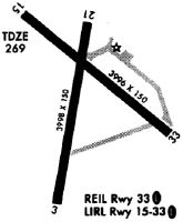
Runway Summary
| Runways: | 03/21 15/33 |
| Longest Runway: | 15/33 is 4000 ft (1219 m) long |
| Runways with an Instrument Approach: |
OWK Airport Runway Details
| Runway 03/21 | 3998 ft x 80 ft (1219 m x 24 m) | |
| Runway Length Source: | 3RD PARTY SURVEY as of 09/02/2013 | |
| Surface: | Asphalt - Fair condition - No special surface treatment | |
Runway Weight Bearing Capacity (in thousands of pounds) |
||
| Single Wheel Landing Gear: | 30.0 | |
| Dual Wheel Landing Gear: | 60.0 | |
Runway 03 |
Runway 21 |
|
Elevation: |
265.0 | 266.2 |
Latitude: |
44-42-32.0596N | 44-43-10.9854N |
Longitude: |
069-52-07.5109W | 069-51-58.2641W |
|
Runway True Alignment: |
010 | 190 |
Glide Path Angle: |
0.0 degrees | 0.0 degrees |
Traffic Pattern: |
Left | Left |
Runway Markings Type: |
Nonprecision Instrument | Basic |
Runway Markings Condition: |
Poor | Poor |
Object at End: |
TREES | TREES |
Object Height: |
21 | 69 |
Distance from End: |
243 | 790 |
Object Centerline Offset: |
121 ft. left of centerline | 180 ft. left of centerline |
| Runway 15/33 | 4000 ft x 100 ft (1219 m x 30 m) | |
| Runway Length Source: | 3RD PARTY SURVEY as of 09/02/2013 | |
| Surface: | Asphalt - Fair condition - No special surface treatment | |
| Runway Edge Lights: | Medium Intensity | |
Runway Weight Bearing Capacity (in thousands of pounds) |
||
| Single Wheel Landing Gear: | 30.0 | |
| Dual Wheel Landing Gear: | 60.0 | |
Runway 15 |
Runway 33 |
|
Elevation: |
264.1 | 258.3 |
Latitude: |
44-43-12.6091N | 44-42-47.4133N |
Longitude: |
069-52-16.9588W | 069-51-34.2988W |
|
Runway True Alignment: |
130 | 310 |
Glide Path Angle: |
3.0 degrees | 0.0 degrees |
Traffic Pattern: |
Left | Left |
Runway Markings Type: |
Nonprecision Instrument | Basic |
Runway Markings Condition: |
Good | Good |
Object at End: |
TREE | TREES |
Object Height: |
35 | 15 |
Distance from End: |
767 | 215 |
Object Centerline Offset: |
121 ft. left of centerline | 180 ft. left of centerline |
Visual Glide Slope Indicators: |
2-Light PAPI On Left Side Of Runway | |
REIL: |
Yes | Yes |
Threshold Crossing Height: |
43 |
Services
Airframe Repair: |
Minor |
Powerplant Repair: |
Minor |
Bottled Oxygen: |
Low Pressure |
Bulk Oxygen: |
None |
Fuel Available: |
100LL, Jet A |
Landing Fees: |
No |
Parking: |
Hangars and tiedowns available |
Maps & Diagrams
OWK Sectional
Flight Planning
at skyvector.com
at skyvector.com