Location
Latitude: |
43-57-41.1000N (43.961417) |
Longitude: |
069-42-45.2000W (-69.712556) |
Elevation: |
70.2 feet MSL (21 m MSL) |
Magnetic Variation: |
14.9 W (as of April 2024 from WMM2020 model) |
Time Zone: |
UTC -5.0 (Standard Time) UTC -4.0 (Daylight Savings Time) |
From City: |
03 N.M. SW of Wiscasset, Maine |
Found On: |
New York Chart |
FAA Region: |
ANE |
Contacts
Manager: |
Publicly owned: |
| RICK TETREV 96 CHEWONKI NECK ROAD, 51 BATH RD WISCASSET, ME 04578 (207) 882-5475 |
TOWN OF WISCASSET 51 BATH RD WISCASSET, ME 04578 (207) 882-8200 |
Operations
Airport Status: |
Operational |
Facility Use: |
Public |
Type: |
Airport |
Activation Date: |
09/1960 |
Control tower: |
No |
Attendance (Months/Days/Hours): |
Months/Days/Hours JAN-MAR/NOT ATTENDED/ |
Boundary ARTCC: |
ZBW (Boston) |
Responsible ARTCC: |
ZBW (Boston) |
Lighting Schedule: |
SEE RMK |
Segmented Circle Indicator: |
Yes |
Traffic Pattern Altitude (MSL): |
1070 feet (326 m) |
NOTAMs Facility: |
IWI |
NOTAM-D Service: |
Yes |
International Airport of Entry: |
No |
Customs Landing Rights: |
No |
Military Landing Rights: |
Yes |
Civil/Military Joint Use: |
No |
Based Aircraft
| Single Engine: | 29 |
| Multi Engine: | 1 |
| GA Helicopters: | 1 |
Annual Operations (as of 08/16/2023)
| Total Operations: | 7200 | |
| Air Taxi: | 275 | 3.8% |
| GA Local: | 3800 | 52.8% |
| GA Itinerant: | 3100 | 43.1% |
| Military Aircraft: | 25 | 0.3% |
Communications
| CTAF: | 122.800 |
| Unicom: | 122.800 |
| Approach: | PORTLAND 119.75 ;112-292 119.75 ;112-292 119.75 ;112-292 119.75 ;112-292 BOSTON ARTCC |
| Departure: | PORTLAND 119.75 ;112-292 119.75 ;112-292 119.75 ;112-292 119.75 ;112-292 BOSTON ARTCC |
| ASOS: | 135.725 (207-882-8094) |
- APCH/DEP SVC PRVDD BY BOSTON ARTCC ON FREQS 128.2/263.05 (112-292) (WATERBORO RCAG); FREQS 124.25/290.50 (293-111) (BANGOR RCAG) WHEN PORTLAND APCH CTL CLSD.
Fixed Based Operators (FBOs) & Fuel
(Click on a business for detail)
Please help us keep this information up to date. This is a FREE SERVICE just like everything else on Airport Guide! If you see that a business needs to be added, modified, or deleted please fill out our Update Form.
To add, modify, or delete a business click here.
Please help us keep this information up to date. This is a FREE SERVICE just like everything else on Airport Guide! If you see that a business needs to be added, modified, or deleted please fill out our Update Form.
Area Code: 207 |
| Business Name | Frequency | Phone | Fuel Grade |
|---|---|---|---|
| Enterprise Rent-A-Car
Update FBO info |
207-882-8393 | ||
| U Save Auto Rental
Update FBO info |
207-442-7733, 800-798-7733 | ||
| Wicked Good Aviation
Website Update FBO info |
Unicom 122.8 | 207-882-5475 | 100LL, Jet A |

|
Phillips | 100LL - 2.35 USD per gallon on 1/19/02 |
24 Hour Self Serve Credit Card Pumps |
|
|
Phillips | Jet A - 2.40 USD per gallon on 1/19/02 |
24 Hour Self Serve Credit Card Pumps Preblended |
Flight Service Stations
| Primary | Alternate | |
| FSS on Field: | N | |
| FSS Name (ID): | Bangor(BGR) | |
| Frequency: | ||
| Toll Free Phone: | 1-800-WX-BRIEF |
Instrument Procedures / Charts
FAA Terminal Procedures valid from 0901Z 03/21/24 to 0901Z 04/18/24.
There are various types of charts available for an airport. They are listed in the Page Type column. Here is a legend for those types:
APD - Airport Diagram
DP - Departure Procedure Charts
HOT - Hot Spots
IAP - Instrument Approach Procedure Charts
MIN - Minimums
STAR - Standard Terminal Arrival Charts
| Page Type | Page Name | Volume | Action Since Last Cycle |
|---|---|---|---|
| IAP | RNAV (GPS) RWY 07 | NE-1 | |
| IAP | RNAV (GPS) RWY 25 | NE-1 | |
| MIN | ALTERNATE MINIMUMS | NE-1 | |
| MIN | TAKEOFF MINIMUMS | NE-1 |
Terminal Procedures are only available for airports in several countries with more being added all the time. If you are looking for a specific country's charts, please send an email to support(at)airportguide.com stating the country name. This will be used to prioritize the implementation.
Navigation Aids (Navaids) near ISS
| Dist (NM) | ID | Morse Code | Name | Type | Freq | True Hdg | Mag Hdg |
|---|---|---|---|---|---|---|---|
| 10.5 | NHZ | _ . . . . . _ _ . . | Brunswick | TACAN | 115.20 | 239 | 254 |
| 21.8 | AUG | . _ . . _ _ _ . | Augusta | VOR-DME | 114.95 | 350 | 365 |
| 22.7 | RM | . _ . _ _ | Noxks | NDB | 334 | 69 | 84 |
| 26.8 | SUH | . . . . . _ . . . . | Sprucehead | NDB | 356 | 78 | 93 |
| 27.0 | LE | . _ . . . | Lewie | NDB | 240 | 270 | 285 |
| 27.7 | AU | . _ . . _ | Dunns | NDB | 366 | 346 | 361 |
| 29.9 | RL | . _ . . _ . . | Bracy | NDB | 399 | 358 | 373 |
| 30.8 | PH | . _ _ . . . . . | Portland Lhb-P | MARINE NDB | 301 | 212 | 227 |
| 31.9 | PWM | . _ _ . . _ _ _ _ | Portland | VOT | 111.00 | 234 | 249 |
| 40.5 | BST | _ . . . . . . _ | Belfast | NDB | 278 | 47 | 62 |
| 46.4 | SZO | . . . _ _ . . _ _ _ | Sebago | NDB | 227 | 266 | 281 |
| 46.7 | BUP | _ . . . . . _ . _ _ . | Burnham | NDB | 348 | 18 | 33 |
| 50.6 | ENE | . _ . . | Kennebunk | VOR-DME | 117.10 | 230 | 245 |
| 63.2 | BGR | _ . . . _ _ . . _ . | Bangor | VOT | 111.00 | 37 | 52 |
| 63.9 | BGR | _ . . . _ _ . . _ . | Bangor | VORTAC | 114.80 | 33 | 48 |
| 65.8 | ESG | . . . . _ _ . | Rollins | NDB | 260 | 227 | 242 |
| 69.6 | BH | _ . . . . . . . | Surry | NDB | 330 | 59 | 74 |
| 71.7 | PSM | . _ _ . . . . _ _ | Pease | DME | 116.5 | 223 | 238 |
| 73.4 | RQM | . _ . _ _ . _ _ _ | Rangeley | NDB | 221 | 323 | 338 |
| 75.0 | BML | _ . . . _ _ . _ . . | Berlin | DME | 116.55 | 303 | 318 |
Nearby Airports with Fuel
Notices to Airmen (NOTAMS)
Remarks
| A110-3 | NOISE SENSITIVE AREA SOUTHWEST OFF EOR 07, CLIMB STRAIGHT OUT TO 700 FT AGL. |
| A110-4 | DEER AND WILDLIFE ON & INVOF ARPT. |
| A110-5 | RWY 7 APCH OBSTN LGTS ON 60 FT. POLES ALG RIGHT SIDE OF APCH LCTD IN 60 FT. TO 70 FT. TALL TREES. |
| A110-6 | FOR CD CTC PORTLAND APCH AT 207-874-7320. WHEN PORTLAND APCH CLSD, CTC BOSTON ARTCC AT 603-879-6859. |
| A16 | EMAIL: AIRPORT@WISCASSET.ORG. EMERG CTC: 207-882-8202 (TOWN DISPATCHER). |
| A58-25 | SCRUB BRUSH 60-100 FT FM RWY END, 80-200 FT R; SCRUB BRUSH 20-43 FT FM RWY END, 140-210 FT L. |
| A70-FUEL-10 | 0LL 24 HR CREDIT CARD FUEL OPN. |
| A75 | CALL 207-882-5475 FOR AVBL OF HNGRS. |
| A81-APT | ACTVT REIL RWY 25; PAPI RWY 07 & 25; MIRL RWY 07/25 - CTAF. |
| E111 | FILED FOR RECORD PURPOSES ONLY. |
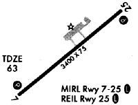
Runways
Runway Summary
| Runways: | 07/25 |
| Longest Runway: | 07/25 is 3397 ft (1035 m) long |
| Runways with an Instrument Approach: |
ISS Airport Runway Details
| Runway 07/25 | 3397 ft x 75 ft (1035 m x 23 m) | |
| Runway Length Source: | 3RD PARTY SURVEY as of 06/11/2010 | |
| Surface: | Asphalt - Excellent condition - No special surface treatment | |
| Runway Edge Lights: | Medium Intensity | |
Runway Weight Bearing Capacity (in thousands of pounds) |
||
| Single Wheel Landing Gear: | 22.0 | |
Runway 07 |
Runway 25 |
|
Elevation: |
70.1 | 55.8 |
Latitude: |
43-57-30.6882N | 43-57-51.4687N |
Longitude: |
069-43-03.4560W | 069-42-27.0048W |
|
Runway True Alignment: |
052 | 232 |
Glide Path Angle: |
4.0 degrees | 3.5 degrees |
Traffic Pattern: |
Left | Right |
Runway Markings Type: |
Nonprecision Instrument | Nonprecision Instrument |
Runway Markings Condition: |
Good | Good |
Object at End: |
POLE | TREE |
Object Height: |
12 | 5 |
Object Marked/Lighted?: |
Lighted | |
Distance from End: |
262 | 255 |
Object Centerline Offset: |
253 ft. right of centerline | 200 ft. right of centerline |
Visual Glide Slope Indicators: |
4-Light PAPI On Right Side Of Runway | 4-Light PAPI On Left Side Of Runway |
REIL: |
No | Yes |
Touchdown Lights: |
No | No |
Centerline Lights: |
No | No |
Threshold Crossing Height: |
40 | 40 |
Services
Airframe Repair: |
Minor |
Powerplant Repair: |
Minor |
Bottled Oxygen: |
None |
Bulk Oxygen: |
None |
Fuel Available: |
100LL, Jet A |
Landing Fees: |
No |
Parking: |
Tiedowns available |
Maps & Diagrams
ISS Sectional
Flight Planning
at skyvector.com
at skyvector.com