Location
Latitude: |
44-24-33.8000N (44.409389) |
Longitude: |
069-00-42.6000W (-69.011833) |
Elevation: |
197.6 feet MSL (60 m MSL) |
Magnetic Variation: |
15.3 W (as of April 2024 from WMM2020 model) |
Time Zone: |
UTC -5.0 (Standard Time) UTC -4.0 (Daylight Savings Time) |
From City: |
01 N.M. SW of Belfast, Maine |
Found On: |
Montreal Chart |
FAA Region: |
ANE |
Contacts
Manager: |
Publicly owned: |
| KENN ORTMANN 22 WRIGHT BROTHERS DR BELFAST, ME 04915 603-970-1947 |
CITY OF BELFAST CITY HALL, 131 CHURCH ST BELFAST, ME 04915 207-338-3370X600 |
Operations
Airport Status: |
Operational |
Facility Use: |
Public |
Type: |
Airport |
Activation Date: |
03/1943 |
Control tower: |
No |
Attendance (Months/Days/Hours): |
Months/Days/Hours IREG |
Boundary ARTCC: |
ZBW (Boston) |
Responsible ARTCC: |
ZBW (Boston) |
Lighting Schedule: |
SEE RMK |
Segmented Circle Indicator: |
Yes |
Traffic Pattern Altitude (MSL): |
1198 feet (365 m) |
NOTAMs Facility: |
BGR |
NOTAM-D Service: |
Yes |
International Airport of Entry: |
No |
Customs Landing Rights: |
No |
Military Landing Rights: |
Yes |
Civil/Military Joint Use: |
No |
Based Aircraft
| Single Engine: | 27 |
Annual Operations (as of 12/31/2023)
| Total Operations: | 3200 | |
| Air Taxi: | 500 | 15.6% |
| GA Local: | 2000 | 62.5% |
| GA Itinerant: | 700 | 21.9% |
Communications
| CTAF: | 122.975 |
| Unicom: | 122.975 |
| Approach: | BANGOR 118.925 118.925 |
| Departure: | BANGOR 118.925 118.925 |
| AWOS-AV: | 122.975 (207-930-7071) |
Fixed Based Operators (FBOs) & Fuel
(Click on a business for detail)
Please help us keep this information up to date. This is a FREE SERVICE just like everything else on Airport Guide! If you see that a business needs to be added, modified, or deleted please fill out our Update Form.
To add, modify, or delete a business click here.
Please help us keep this information up to date. This is a FREE SERVICE just like everything else on Airport Guide! If you see that a business needs to be added, modified, or deleted please fill out our Update Form.
Area Code: 207 |
| Business Name | Frequency | Phone | Fuel Grade |
|---|---|---|---|
| Ace Aviation, Inc.
Update FBO info |
Unicom 122.8 | 338-2970 | 100LL |
Flight Service Stations
| Primary | Alternate | |
| FSS on Field: | N | |
| FSS Name (ID): | Bangor(BGR) | |
| Frequency: | ||
| Toll Free Phone: | 1-800-WX-BRIEF |
Instrument Procedures / Charts
FAA Terminal Procedures valid from 0901Z 03/21/24 to 0901Z 04/18/24.
There are various types of charts available for an airport. They are listed in the Page Type column. Here is a legend for those types:
APD - Airport Diagram
DP - Departure Procedure Charts
HOT - Hot Spots
IAP - Instrument Approach Procedure Charts
MIN - Minimums
STAR - Standard Terminal Arrival Charts
| Page Type | Page Name | Volume | Action Since Last Cycle |
|---|---|---|---|
| IAP | RNAV (GPS) RWY 15 | NE-1 | |
| IAP | RNAV (GPS) RWY 33 | NE-1 | |
| MIN | TAKEOFF MINIMUMS | NE-1 |
Terminal Procedures are only available for airports in several countries with more being added all the time. If you are looking for a specific country's charts, please send an email to support(at)airportguide.com stating the country name. This will be used to prioritize the implementation.
Navigation Aids (Navaids) near KBST
| Dist (NM) | ID | Morse Code | Name | Type | Freq | True Hdg | Mag Hdg |
|---|---|---|---|---|---|---|---|
| 0.1 | BST | _ . . . . . . _ | Belfast | NDB | 278 | 18 | 33 |
| 20.9 | RM | . _ . _ _ | Noxks | NDB | 334 | 205 | 220 |
| 21.9 | SUH | . . . . . _ . . . . | Sprucehead | NDB | 356 | 190 | 205 |
| 22.8 | BUP | _ . . . . . _ . _ _ . | Burnham | NDB | 348 | 319 | 334 |
| 24.8 | BGR | _ . . . _ _ . . _ . | Bangor | VOT | 111.00 | 19 | 34 |
| 26.6 | BGR | _ . . . _ _ . . _ . | Bangor | VORTAC | 114.80 | 12 | 27 |
| 31.1 | RL | . _ . . _ . . | Bracy | NDB | 399 | 275 | 290 |
| 31.2 | BH | _ . . . . . . . | Surry | NDB | 330 | 75 | 90 |
| 34.1 | AUG | . _ . . _ _ _ . | Augusta | VOR-DME | 114.95 | 261 | 276 |
| 36.4 | AU | . _ . . _ | Dunns | NDB | 366 | 270 | 285 |
| 39.2 | OLD | _ _ _ . _ . . _ . . | Old Town | NDB | 272 | 24 | 39 |
| 50.7 | NHZ | _ . . . . . _ _ . . | Brunswick | TACAN | 115.20 | 230 | 245 |
| 63.0 | LE | . _ . . . | Lewie | NDB | 240 | 245 | 260 |
| 70.5 | PH | . _ _ . . . . . | Portland Lhb-P | MARINE NDB | 301 | 221 | 236 |
| 72.2 | PWM | . _ _ . . _ _ _ _ | Portland | VOT | 111.00 | 231 | 246 |
| 73.7 | MLT | _ _ . _ . . _ | Millinocket | VOR-DME | 117.90 | 16 | 32 |
| 76.9 | LNT | . _ . . _ . _ | Milnot | NDB | 344 | 14 | 30 |
| 78.3 | PNN | . _ _ . _ . _ . | Princeton | DME | 114.3 | 44 | 60 |
| 80.6 | RQM | . _ . _ _ . _ _ _ | Rangeley | NDB | 221 | 293 | 308 |
| 82.0 | SZO | . . . _ _ . . _ _ _ | Sebago | NDB | 227 | 248 | 263 |
Nearby Airports with Fuel
Notices to Airmen (NOTAMS)
Remarks
| A110-14 | FOR CD CTC BANGOR APCH AT 207-561-2500 EXT 1. |
| A110-15 | 800 FT X 30 FT PARL TURF LDG AREA E OF RWY & N OF TWY B - AMGR. |
| A110-16 | FAA WX CAMERA INFO AVBL AT HTTPS://WEATHERCAMS.FAA.GOV/MAP/-69.61024,44.01514,-67.21384,44.80289/CAMERASITE/600/DETAILS/CAMERA. |
| A110-6 | AWOS AVBL - CTAF 2 CLICKS OR 207-930-7071. |
| A110-8 | DEER & BIRDS ON & INVOF ARPT. |
| A110-9 | SFC COND RPRTD DAILY 1400-2200Z DEC-MAR. |
| A15 | SEND ALL MGR CORRESPONDANCE TO CITY HALL 131 CHURCH ST. BELFAST, ME 04915. |
| A52-33 | 80 FT TALL OBSTN LGTS ALG BOTH SIDES OF PRI SFC AT EDGE OF TREE LINE. |
| A58-15 | 8 FT BRUSH 140-200 FT FM THR, 75-250 FT R OF CNTRLN; 4-10 FT BRUSH 60-200 FT FM THR, 200-250 FT L OF CNTRLN. |
| A58-33 | 4-8 FT BRUSH 30-200 FT FM THR, 90-200 FT R OF CNTRLN. |
| A75 | CALL AHD FOR AVBLTY. |
| A81-APT | ACTVT REIL RWY 15 & 33; MIRL RWY 15/33 - CTAF. |
| E111 | EXISTED PRIOR TO 1959. |
Runways
Runway Summary
| Runways: | 15/33 |
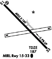
| Longest Runway: | 15/33 is 4000 ft (1219 m) long |
| Runways with an Instrument Approach: |
KBST Seaplane Base Runway Details
| Runway 15/33 | 4000 ft x 100 ft (1219 m x 30 m) | |
| Runway Length Source: | 3RD PARTY SURVEY as of 06/15/2010 | |
| Surface: | Asphalt - Good condition - No special surface treatment | |
| Runway Edge Lights: | Medium Intensity | |
Runway Weight Bearing Capacity (in thousands of pounds) |
||
| Single Wheel Landing Gear: | 30.0 | |
Runway 15 |
Runway 33 |
|
Elevation: |
197.5 | 158.5 |
Latitude: |
44-24-47.3914N | 44-24-20.2352N |
Longitude: |
069-01-02.5964W | 069-00-22.5819W |
|
Runway True Alignment: |
133 | 313 |
Glide Path Angle: |
0.0 degrees | 0.0 degrees |
Traffic Pattern: |
Left | Left |
Runway Markings Type: |
Nonprecision Instrument | Nonprecision Instrument |
Runway Markings Condition: |
Good | Good |
Object at End: |
TREE | TREE |
Object Height: |
10 | 18 |
Distance from End: |
213 | 330 |
Object Centerline Offset: |
150 ft. left of centerline | 220 ft. right of centerline |
REIL: |
Yes | Yes |
Services
Fuel Available: |
100LL |
Maps & Diagrams
KBST Sectional
Flight Planning
at skyvector.com
at skyvector.com