Location
Latitude: |
45-00-16.2270N (45.004508) |
Longitude: |
069-14-14.7720W (-69.237437) |
Elevation: |
533.3 feet MSL (163 m MSL) |
Magnetic Variation: |
15.3 W (as of April 2024 from WMM2020 model) |
Time Zone: |
UTC -5.0 (Standard Time) UTC -4.0 (Daylight Savings Time) |
From City: |
03 N.M. E of Dexter, Maine |
Found On: |
Montreal Chart |
FAA Region: |
ANE |
Contacts
Manager: |
Publicly owned: |
| ROGER NELSON 129 OLD BANGOR RD NEWPORT, ME 04953 207-270-0239 |
TOWN OF DEXTER TOWN OFFICE BLDG, 23 MAIN DEXTER, ME 04930 207-924-7351 |
Operations
Airport Status: |
Operational |
Facility Use: |
Public |
Type: |
Airport |
Activation Date: |
03/1948 |
Control tower: |
No |
Attendance (Months/Days/Hours): |
Months/Days/Hours Unattended |
Boundary ARTCC: |
ZBW (Boston) |
Responsible ARTCC: |
ZBW (Boston) |
Lighting Schedule: |
SEE RMK |
Segmented Circle Indicator: |
Yes |
Traffic Pattern Altitude (MSL): |
1533 feet (467 m) |
NOTAMs Facility: |
BGR |
NOTAM-D Service: |
Yes |
International Airport of Entry: |
No |
Customs Landing Rights: |
No |
Military Landing Rights: |
Yes |
Civil/Military Joint Use: |
No |
Based Aircraft
| Single Engine: | 22 |
Annual Operations (as of 08/25/2020)
| Total Operations: | 7600 | |
| GA Local: | 6400 | 84.2% |
| GA Itinerant: | 1000 | 13.2% |
| Military Aircraft: | 200 | 2.6% |
Communications
| CTAF: | 122.800 |
| Unicom: | 122.800 |
| Approach: | BANGOR 118.925 118.925 |
| Departure: | BANGOR 118.925 118.925 |
Fixed Based Operators (FBOs) & Fuel
(Click on a business for detail)
Please help us keep this information up to date. This is a FREE SERVICE just like everything else on Airport Guide! If you see that a business needs to be added, modified, or deleted please fill out our Update Form.
To add, modify, or delete a business click here.
Please help us keep this information up to date. This is a FREE SERVICE just like everything else on Airport Guide! If you see that a business needs to be added, modified, or deleted please fill out our Update Form.
Area Code: 207 |
| Business Name | Frequency | Phone | Fuel Grade |
|---|---|---|---|
| Barnstorm Aviation
Update FBO info |
362-3881 |
Flight Service Stations
| Primary | Alternate | |
| FSS on Field: | N | |
| FSS Name (ID): | Bangor(BGR) | |
| Frequency: | ||
| Toll Free Phone: | 1-800-WX-BRIEF |
Instrument Procedures / Charts
FAA Terminal Procedures valid from 0901Z 03/21/24 to 0901Z 04/18/24.
There are various types of charts available for an airport. They are listed in the Page Type column. Here is a legend for those types:
APD - Airport Diagram
DP - Departure Procedure Charts
HOT - Hot Spots
IAP - Instrument Approach Procedure Charts
MIN - Minimums
STAR - Standard Terminal Arrival Charts
| Page Type | Page Name | Volume | Action Since Last Cycle |
|---|---|---|---|
| IAP | RNAV (GPS) RWY 16 | NE-1 | |
| IAP | RNAV (GPS) RWY 34 | NE-1 | |
| MIN | TAKEOFF MINIMUMS | NE-1 |
Terminal Procedures are only available for airports in several countries with more being added all the time. If you are looking for a specific country's charts, please send an email to support(at)airportguide.com stating the country name. This will be used to prioritize the implementation.
Navigation Aids (Navaids) near 1B0
| Dist (NM) | ID | Morse Code | Name | Type | Freq | True Hdg | Mag Hdg |
|---|---|---|---|---|---|---|---|
| 18.3 | BGR | _ . . . _ _ . . _ . | Bangor | VORTAC | 114.80 | 122 | 137 |
| 19.1 | BUP | _ . . . . . _ . _ _ . | Burnham | NDB | 348 | 195 | 210 |
| 21.7 | BGR | _ . . . _ _ . . _ . | Bangor | VOT | 111.00 | 124 | 139 |
| 25.6 | OLD | _ _ _ . _ . . _ . . | Old Town | NDB | 272 | 89 | 104 |
| 36.9 | BST | _ . . . . . . _ | Belfast | NDB | 278 | 164 | 179 |
| 38.9 | RL | . _ . . _ . . | Bracy | NDB | 399 | 213 | 228 |
| 44.4 | AU | . _ . . _ | Dunns | NDB | 366 | 216 | 231 |
| 46.4 | MLT | _ _ . _ . . _ | Millinocket | VOR-DME | 117.90 | 40 | 56 |
| 47.5 | AUG | . _ . . _ _ _ . | Augusta | VOR-DME | 114.95 | 210 | 225 |
| 48.3 | LNT | . _ . . _ . _ | Milnot | NDB | 344 | 36 | 52 |
| 48.5 | BH | _ . . . . . . . | Surry | NDB | 330 | 124 | 139 |
| 54.7 | RM | . _ . _ _ | Noxks | NDB | 334 | 179 | 194 |
| 57.5 | SUH | . . . . . _ . . . . | Sprucehead | NDB | 356 | 174 | 189 |
| 64.4 | RQM | . _ . _ _ . _ _ _ | Rangeley | NDB | 221 | 266 | 281 |
| 67.7 | PNN | . _ _ . _ . _ . | Princeton | DME | 114.3 | 72 | 88 |
| 73.9 | NHZ | _ . . . . . _ _ . . | Brunswick | TACAN | 115.20 | 203 | 218 |
| 78.3 | LE | . _ . . . | Lewie | NDB | 240 | 217 | 232 |
| 85.7 | HUL | . . . . . . _ . _ . . | Houlton | DME | 116.1 | 43 | 59 |
| 85.9 | BML | _ . . . _ _ . _ . . | Berlin | DME | 116.55 | 255 | 270 |
| 87.4 | VLV | . . . _ . _ . . . . . _ | Beauce | VOR-DME | 117.20 | 309 | 324 |
Nearby Airports with Fuel
Notices to Airmen (NOTAMS)
Remarks
| A110-4 | WILDLIFE ON OR INVOF ARPT. |
| A110-5 | FOR CD CTC BANGOR APCH AT 207-561-2500 EXT 1. |
| A70-FUEL-10 | 0LL 24 HR FUEL WITH MAJOR CREDIT CARD, NO ETHANOL IN MOGAS. |
| A75 | BRING OWN TIE DOWNS. |
| A81-APT | ACTVT MIRL RWY 16/34 - CTAF. |
| E111 | EXISTED PRIOR TO 1959. |
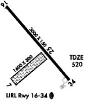
Runways
Runway Summary
| Runways: | 07/25 16/34 |
| Longest Runway: | 16/34 is 3008 ft (917 m) long |
| Runways with an Instrument Approach: |
1B0 Airport Runway Details
| Runway 07/25 | 1249 ft x 120 ft (381 m x 37 m) | |
| Runway Length Source: | 3RD PARTY SURVEY as of 06/29/2018 | |
| Surface: | Turf - No special surface treatment | |
Runway 07 |
Runway 25 |
|
Elevation: |
533.3 | 526.4 |
Latitude: |
45-00-07.5997N | 45-00-15.6292N |
Longitude: |
069-14-23.7704W | 069-14-10.5701W |
|
Runway True Alignment: |
049 | 229 |
Glide Path Angle: |
0.0 degrees | 0.0 degrees |
Runway Markings Condition: |
Fair | Fair |
| Runway 16/34 | 3008 ft x 75 ft (917 m x 23 m) | |
| Runway Length Source: | 3RD PARTY SURVEY as of 06/29/2018 | |
| Surface: | Turf - No special surface treatment | |
| Runway Edge Lights: | Medium Intensity | |
Runway Weight Bearing Capacity (in thousands of pounds) |
||
| Single Wheel Landing Gear: | 30.0 | |
Runway 16 |
Runway 34 |
|
Elevation: |
520.8 | 523.7 |
Latitude: |
45-00-29.3949N | 45-00-06.8906N |
Longitude: |
069-14-27.4387W | 069-14-00.1152W |
|
Runway True Alignment: |
139 | 319 |
Glide Path Angle: |
0.0 degrees | 0.0 degrees |
Traffic Pattern: |
Left | Left |
Runway Markings Type: |
Nonprecision Instrument | Nonprecision Instrument |
Runway Markings Condition: |
Good | Good |
REIL: |
No | No |
Touchdown Lights: |
No | No |
Centerline Lights: |
No | No |
Services
Airframe Repair: |
Major |
Powerplant Repair: |
Major |
Bottled Oxygen: |
High Pressure / Low Pressure |
Bulk Oxygen: |
High Pressure / Low Pressure |
Fuel Available: |
100LL |
Landing Fees: |
No |
Parking: |
Hangars and tiedowns available |
Maps & Diagrams
1B0 Sectional
Flight Planning
at skyvector.com
at skyvector.com