Location
Latitude: |
44-25-30.6000N (44.425167) |
Longitude: |
070-48-35.7000W (-70.809917) |
Elevation: |
674.0 feet MSL (205 m MSL) |
Magnetic Variation: |
14.7 W (as of April 2024 from WMM2020 model) |
Time Zone: |
UTC -5.0 (Standard Time) UTC -4.0 (Daylight Savings Time) |
From City: |
02 N.M. NW of Bethel, Maine |
Found On: |
Montreal Chart |
FAA Region: |
ANE |
Contacts
Manager: |
Publicly owned: |
| RANDY AUTREY TOWN OF BETHEL, PO BOX 1660 BETHEL, ME 04217 207-381-0202 |
TOWN OF BETHEL PO BOX 1660 BETHEL, ME 04217 207-824-2669 |
Operations
Airport Status: |
Operational |
Facility Use: |
Public |
Type: |
Airport |
Activation Date: |
12/2001 |
Control tower: |
No |
Attendance (Months/Days/Hours): |
Months/Days/Hours Unattended |
Boundary ARTCC: |
ZBW (Boston) |
Responsible ARTCC: |
ZBW (Boston) |
Lighting Schedule: |
SEE RMK |
Segmented Circle Indicator: |
Yes |
Traffic Pattern Altitude (MSL): |
1674 feet (510 m) |
NOTAMs Facility: |
BGR |
NOTAM-D Service: |
Yes |
International Airport of Entry: |
No |
Customs Landing Rights: |
No |
Military Landing Rights: |
No |
Civil/Military Joint Use: |
No |
Based Aircraft
| Single Engine: | 15 |
| Multi Engine: | 1 |
Annual Operations (as of 08/08/2022)
| Total Operations: | 4750 | |
| GA Local: | 2500 | 52.6% |
| GA Itinerant: | 2000 | 42.1% |
| Military Aircraft: | 250 | 5.3% |
Communications
| CTAF: | 122.900 |
| Approach: | PORTLAND 125.5 125.5 BOSTON ARTCC |
| Departure: | PORTLAND 125.5 125.5 BOSTON ARTCC |
| AWOS-AV: | 119.075 (207-512-2516) |
- APCH/DEP SVC PRVDD BY BOSTON ARTCC ON FREQS 128.2/263.05 (WATERBORO RCAG) WHEN PORTLAND APCH CTL CLSD.
Fixed Based Operators (FBOs) & Fuel
(Click on a business for detail)
Please help us keep this information up to date. This is a FREE SERVICE just like everything else on Airport Guide! If you see that a business needs to be added, modified, or deleted please fill out our Update Form.
To add, modify, or delete a business click here.
Please help us keep this information up to date. This is a FREE SERVICE just like everything else on Airport Guide! If you see that a business needs to be added, modified, or deleted please fill out our Update Form.
Area Code: 207 |
| Business Name | Frequency | Phone | Fuel Grade |
|---|---|---|---|
| Bethel Air Service
Update FBO info |
Unicom 122.9 | 824-4321 | 100LL, Jet A |
Flight Service Stations
| Primary | Alternate | |
| FSS on Field: | N | |
| FSS Name (ID): | Bangor(BGR) | |
| Frequency: | ||
| Toll Free Phone: | 1-800-WX-BRIEF |
Instrument Procedures / Charts
FAA Terminal Procedures valid from 0901Z 03/21/24 to 0901Z 04/18/24.
There are various types of charts available for an airport. They are listed in the Page Type column. Here is a legend for those types:
APD - Airport Diagram
DP - Departure Procedure Charts
HOT - Hot Spots
IAP - Instrument Approach Procedure Charts
MIN - Minimums
STAR - Standard Terminal Arrival Charts
| Page Type | Page Name | Volume | Action Since Last Cycle |
|---|---|---|---|
| IAP | RNAV (GPS) Y RWY 32 | NE-1 | |
| MIN | TAKEOFF MINIMUMS | NE-1 |
Terminal Procedures are only available for airports in several countries with more being added all the time. If you are looking for a specific country's charts, please send an email to support(at)airportguide.com stating the country name. This will be used to prioritize the implementation.
Navigation Aids (Navaids) near 0B1
| Dist (NM) | ID | Morse Code | Name | Type | Freq | True Hdg | Mag Hdg |
|---|---|---|---|---|---|---|---|
| 20.4 | BML | _ . . . _ _ . _ . . | Berlin | DME | 116.55 | 307 | 322 |
| 30.7 | RQM | . _ . _ _ . _ _ _ | Rangeley | NDB | 221 | 4 | 19 |
| 31.3 | SZO | . . . _ _ . . _ _ _ | Sebago | NDB | 227 | 177 | 192 |
| 32.5 | HIE | . . . . . . . | Witey | FAN MARKER | 264 | 279 | |
| 34.4 | LE | . _ . . . | Lewie | NDB | 240 | 143 | 158 |
| 37.7 | GMA | _ _ . _ _ . _ | Mahn | NDB | 386 | 264 | 279 |
| 40.7 | AU | . _ . . _ | Dunns | NDB | 366 | 90 | 105 |
| 43.9 | AUG | . _ . . _ _ _ . | Augusta | VOR-DME | 114.95 | 97 | 112 |
| 46.1 | RL | . _ . . _ . . | Bracy | NDB | 399 | 87 | 102 |
| 50.6 | NHZ | _ . . . . . _ _ . . | Brunswick | TACAN | 115.20 | 130 | 145 |
| 51.5 | PWM | . _ _ . . _ _ _ _ | Portland | VOT | 111.00 | 154 | 169 |
| 52.4 | LLX | . _ . . . _ . . _ . . _ | Lyndonville | NDB | 353 | 275 | 289 |
| 58.3 | LCI | . _ . . _ . _ . . . | Laconia | FAN MARKER | 208 | 222 | |
| 60.6 | ENE | . _ . . | Kennebunk | VOR-DME | 117.10 | 171 | 186 |
| 61.9 | LC | . _ . . _ . _ . | Blnap | NDB | 328 | 210 | 224 |
| 62.2 | PH | . _ _ . . . . . | Portland Lhb-P | MARINE NDB | 301 | 149 | 164 |
| 64.2 | BUP | _ . . . . . _ . _ _ . | Burnham | NDB | 348 | 74 | 89 |
| 67.7 | YSC | _ . _ _ . . . _ . _ . | Sherbrooke | VOR-DME | 113.20 | 322 | 337 |
| 71.2 | RM | . _ . _ _ | Noxks | NDB | 334 | 105 | 120 |
| 72.3 | ESG | . . . . _ _ . | Rollins | NDB | 260 | 180 | 195 |
Nearby Airports with Fuel
Notices to Airmen (NOTAMS)
Remarks
| A110-10 | TURKEYS & GEESE ON OR INVOF ARPT. |
| A110-12 | FOR CD CTC PORTLAND APCH AT 207-874-7320, WHEN APCH CLSD CTC BOSTON ARTCC AT 603-879-6859. |
| A110-13 | COLD TEMPERATURE AIRPORT. ALTITUDE CORRECTION REQUIRED AT OR BELOW -23C. |
| A110-2 | UNLGTD MTUS TRRN. |
| A110-3 | FOR RWY CONDS OR OTHER INFO, CTC ARPT INFO LINE 207-512-5552. |
| A110-4 | PWRD PRCHT ACTVTY OCNLY IN TRML AREA. |
| A110-5 | NO FEES FOR PRKG, TIE-DOWN, OVNGT ELECL A/C HOOK-UP. |
| A110-6 | ARPT SFC CONDS UNMON BTN 0200-1300Z DLY. |
| A110-8 | UAS WI 3 NM RDS OF ARPT SFC-400 FT AGL DLY, SR-SS. |
| A14 | TOWN MGR.. ADDITIONAL CONTACT: RANDY AUTREY - DEPUTY AIRPORT MGR. (207-824-2669) |
| A16 | EMERG (POLICE) 1-800-733-1421. |
| A58-14 | 30-60 FT TREES 40-60 FT FM END OF RWY 195-250 FT R OF CNTRLN. |
| A70-FUEL-10 | 0LL SELF-SERVE AVBL 24 HRS WITH CREDIT CARD. |
| A81-APT | ACTVT REIL RWY 32; MIRL RWY 14/32 - CTAF. |
| A83 | LGTD WINDSOCK AND APN LGTS ON CONSLY AT NGT. |
| E111 | EXISTED PRIOR TO 1959. |
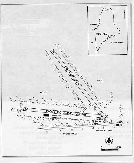
Runways
Runway Summary
| Runways: | 14/32 |
| Longest Runway: | 14/32 is 3818 ft (1164 m) long |
| Runways with an Instrument Approach: |
0B1 Airport Runway Details
| Runway 14/32 | 3818 ft x 75 ft (1164 m x 23 m) | |
| Runway Length Source: | 3RD PARTY SURVEY as of 07/22/2010 | |
| Surface: | Asphalt - Good condition - No special surface treatment | |
| Runway Edge Lights: | Medium Intensity | |
Runway 14 |
Runway 32 |
|
Elevation: |
674.0 | 656.2 |
Latitude: |
44-25-41.6898N | 44-25-19.4109N |
Longitude: |
070-48-56.9095W | 070-48-14.4755W |
Glide Path Angle: |
0.0 degrees | 0.0 degrees |
Runway Markings Type: |
Basic | Nonprecision Instrument |
Runway Markings Condition: |
Fair | Fair |
Object at End: |
TREE | TREE |
Object Height: |
14 | 17 |
Distance from End: |
242 | 423 |
Object Centerline Offset: |
199 ft. right of centerline | 184 ft. right of centerline |
REIL: |
Yes |
Services
Airframe Repair: |
Major |
Powerplant Repair: |
Major |
Bottled Oxygen: |
None |
Bulk Oxygen: |
None |
Fuel Available: |
100LL, Jet A+ |
Landing Fees: |
No |
Parking: |
Hangars and tiedowns available |
Maps & Diagrams
0B1 Sectional
Flight Planning
at skyvector.com
at skyvector.com