Location
Latitude: |
44-31-59.7000N (44.53325) |
Longitude: |
069-40-31.9000W (-69.675528) |
Elevation: |
332.8 feet MSL (101 m MSL) |
Magnetic Variation: |
15.1 W (as of April 2024 from WMM2020 model) |
Time Zone: |
UTC -5.0 (Standard Time) UTC -4.0 (Daylight Savings Time) |
From City: |
02 N.M. SW of Waterville, Maine |
Found On: |
Montreal Chart |
FAA Region: |
ANE |
Contacts
Manager: |
Publicly owned: |
| RANDY MARSHALL JR 2 LAFLUER RD WATERVILLE, ME 04901 207-861-8013 |
CITY OF WATERVILLE 1 COMMON ST WATERVILLE, ME 04901 207-861-8013 |
Operations
Airport Status: |
Operational |
Facility Use: |
Public |
Type: |
Airport |
Activation Date: |
04/1940 |
Control tower: |
No |
Attendance (Months/Days/Hours): |
Months/Days/Hours MAY-OCT/ALL/0900-1700 |
Boundary ARTCC: |
ZBW (Boston) |
Responsible ARTCC: |
ZBW (Boston) |
Lighting Schedule: |
SEE RMK |
Segmented Circle Indicator: |
Yes |
Traffic Pattern Altitude (MSL): |
1333 feet (406 m) |
NOTAMs Facility: |
WVL |
NOTAM-D Service: |
Yes |
International Airport of Entry: |
No |
Customs Landing Rights: |
No |
Military Landing Rights: |
Yes |
Civil/Military Joint Use: |
No |
Based Aircraft
| Single Engine: | 18 |
| Multi Engine: | 2 |
Annual Operations (as of 08/24/2023)
| Total Operations: | 16200 | |
| GA Local: | 8000 | 49.4% |
| GA Itinerant: | 8000 | 49.4% |
| Military Aircraft: | 200 | 1.2% |
Communications
| CTAF: | 122.700 |
| Unicom: | 122.700 |
| Clearance Del.: | 124.6 124.6 124.6 124.6 |
| Approach: | PORTLAND BOSTON ARTCC |
| Departure: | PORTLAND BOSTON ARTCC |
| AWOS-3PT: | 118.375 (207-877-0519) |
- APCH/DEP SVC PRVDD BY BOSTON ARTCC ON FREQS 128.2/263.05 (112-292) (WATERBORO RCAG); FREQS 124.25/290.50 (293-111) (BANGOR RCAG) WHEN PORTLAND APCH CTL CLSD.
Fixed Based Operators (FBOs) & Fuel
(Click on a business for detail)
Please help us keep this information up to date. This is a FREE SERVICE just like everything else on Airport Guide! If you see that a business needs to be added, modified, or deleted please fill out our Update Form.
To add, modify, or delete a business click here.
Please help us keep this information up to date. This is a FREE SERVICE just like everything else on Airport Guide! If you see that a business needs to be added, modified, or deleted please fill out our Update Form.
Area Code: 207 |
| Business Name | Frequency | Phone | Fuel Grade |
|---|---|---|---|
| Telford Aviation
Update FBO info |
Unicom 122.7 | 872-5555 | 100LL, Jet A |
Flight Service Stations
| Primary | Alternate | |
| FSS on Field: | N | |
| FSS Name (ID): | Bangor(BGR) | |
| Frequency: | ||
| Toll Free Phone: | 1-800-WX-BRIEF |
Instrument Procedures / Charts
FAA Terminal Procedures valid from 0901Z 03/21/24 to 0901Z 04/18/24.
There are various types of charts available for an airport. They are listed in the Page Type column. Here is a legend for those types:
APD - Airport Diagram
DP - Departure Procedure Charts
HOT - Hot Spots
IAP - Instrument Approach Procedure Charts
MIN - Minimums
STAR - Standard Terminal Arrival Charts
| Page Type | Page Name | Volume | Action Since Last Cycle |
|---|---|---|---|
| IAP | ILS OR LOC/DME RWY 05 | NE-1 | Changed |
| IAP | RNAV (GPS) RWY 05 | NE-1 | Changed |
| IAP | RNAV (GPS) RWY 23 | NE-1 | Changed |
| MIN | ALTERNATE MINIMUMS | NE-1 | |
| MIN | TAKEOFF MINIMUMS | NE-1 |
Terminal Procedures are only available for airports in several countries with more being added all the time. If you are looking for a specific country's charts, please send an email to support(at)airportguide.com stating the country name. This will be used to prioritize the implementation.
Navigation Aids (Navaids) near WVL
| Dist (NM) | ID | Morse Code | Name | Type | Freq | True Hdg | Mag Hdg |
|---|---|---|---|---|---|---|---|
| 5.1 | RL | . _ . . _ . . | Bracy | NDB | 399 | 210 | 225 |
| 10.8 | AU | . _ . . _ | Dunns | NDB | 366 | 227 | 242 |
| 13.8 | AUG | . _ . . _ _ _ . | Augusta | VOR-DME | 114.95 | 202 | 217 |
| 16.8 | BUP | _ . . . . . _ . _ _ . | Burnham | NDB | 348 | 53 | 68 |
| 29.4 | BST | _ . . . . . . _ | Belfast | NDB | 278 | 104 | 119 |
| 32.9 | RM | . _ . _ _ | Noxks | NDB | 334 | 143 | 158 |
| 38.0 | SUH | . . . . . _ . . . . | Sprucehead | NDB | 356 | 139 | 154 |
| 38.9 | BGR | _ . . . _ _ . . _ . | Bangor | VORTAC | 114.80 | 61 | 76 |
| 40.0 | BGR | _ . . . _ _ . . _ . | Bangor | VOT | 111.00 | 66 | 81 |
| 41.0 | NHZ | _ . . . . . _ _ . . | Brunswick | TACAN | 115.20 | 195 | 210 |
| 44.5 | LE | . _ . . . | Lewie | NDB | 240 | 219 | 234 |
| 51.8 | RQM | . _ . _ _ . _ _ _ | Rangeley | NDB | 221 | 298 | 313 |
| 52.6 | OLD | _ _ _ . _ . . _ . . | Old Town | NDB | 272 | 57 | 72 |
| 58.5 | BH | _ . . . . . . . | Surry | NDB | 330 | 89 | 104 |
| 59.7 | PWM | . _ _ . . _ _ _ _ | Portland | VOT | 111.00 | 207 | 222 |
| 60.7 | SZO | . . . _ _ . . _ _ _ | Sebago | NDB | 227 | 231 | 246 |
| 63.0 | PH | . _ _ . . . . . | Portland Lhb-P | MARINE NDB | 301 | 196 | 211 |
| 64.8 | BML | _ . . . _ _ . _ . . | Berlin | DME | 116.55 | 275 | 290 |
| 77.8 | ENE | . _ . . | Kennebunk | VOR-DME | 117.10 | 211 | 226 |
| 80.1 | MLT | _ _ . _ . . _ | Millinocket | VOR-DME | 117.90 | 37 | 52 |
Nearby Airports with Fuel
Notices to Airmen (NOTAMS)
Remarks
| A110*G | THIS AIRPORT HAS BEEN SURVEYED BY THE NATIONAL GEODETIC SURVEY. |
| A110-6 | ACFT OPNS ON PAVED AREA ONLY. |
| A110-7 | AVOID HOSPITAL 1 MI NORTH. |
| A110-8 | ACFT DE-ICING AVBL. |
| A110-9 | FOR CD WHEN APCH CLSD CTC BOSTON ARTCC AT 603-879-6859. |
| A16 | EMAIL: AIRPORT@WATERVILLE-ME.GOV. |
| A70-FUEL-10 | 0LL FOR FUEL AFT HRS EMAIL: AIRPORT@WATERVILLE-ME.GOV. |
| A75 | CALL AHEAD FOR AVBL. |
| A81-APT | ACTVT MALSF RWY 05; REIL RWY 23; HIRL RWY 05/23 - CTAF. |
| E111 | EXISTED PRIOR TO 1959. |
Runways
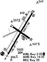
Runway Summary
| Runways: | 05/23 14/32 |
| Longest Runway: | 05/23 is 5500 ft (1676 m) long |
| Runways with an Instrument Approach: | 05 |
WVL Airport Runway Details
| Runway 05/23 | 5500 ft x 100 ft (1676 m x 30 m) | |
| Runway Length Source: | NGS as of 06/26/1996 | |
| Surface: | Asphalt - Excellent condition - Saw-cut or plastic grooved | |
| Runway Edge Lights: | High Intensity | |
Runway Weight Bearing Capacity (in thousands of pounds) |
||
| Single Wheel Landing Gear: | 40.0 | |
| Dual Wheel Landing Gear: | 60.0 | |
| Dual Tandem Wheel Landing Gear: | 105.0 | |
Runway 05 |
Runway 23 |
|
Elevation: |
267.9 | 332.8 |
Latitude: |
44-31-35.4680N | 44-32-23.1600N |
Longitude: |
069-40-50.2800W | 069-40-13.9600W |
|
Runway True Alignment: |
029 | 209 |
ILS Type: |
ILS/DME | |
Glide Path Angle: |
3.0 degrees | 3.0 degrees |
Traffic Pattern: |
Left | Left |
Runway Markings Type: |
Precision Instrument | Precision Instrument |
Runway Markings Condition: |
Good | Good |
Visual Glide Slope Indicators: |
4-Box VASI On Left Side Of Runway | 4-Light PAPI On Left Side Of Runway |
Approach Light System: |
1,400 Foot Medium Intensity Approach Lighting System With Sequenced Flashers | |
REIL: |
No | Yes |
Touchdown Lights: |
No | No |
Centerline Lights: |
No | No |
Threshold Crossing Height: |
51 | 40 |
| Runway 14/32 | 2301 ft x 60 ft (701 m x 18 m) | |
| Runway Length Source: | STATE as of 02/13/2013 | |
| Surface: | Asphalt - Excellent condition - No special surface treatment | |
Runway Weight Bearing Capacity (in thousands of pounds) |
||
| Single Wheel Landing Gear: | 25.0 | |
Runway 14 |
Runway 32 |
|
Elevation: |
307.6 | 298.6 |
Latitude: |
44-32-07.2210N | 44-31-54.1120N |
Longitude: |
069-40-44.1990W | 069-40-18.2600W |
|
Runway True Alignment: |
125 | 305 |
Glide Path Angle: |
0.0 degrees | 0.0 degrees |
Traffic Pattern: |
Left | Left |
Runway Markings Type: |
Basic | Basic |
Runway Markings Condition: |
Fair | Fair |
Object at End: |
TREES | |
Object Height: |
15 | |
Distance from End: |
402 | |
REIL: |
No | No |
Touchdown Lights: |
No | No |
Centerline Lights: |
No | No |
Services
Airframe Repair: |
None |
Powerplant Repair: |
None |
Fuel Available: |
100LL |
Landing Fees: |
No |
Parking: |
Hangars and tiedowns available |
Maps & Diagrams
WVL Sectional
Flight Planning
at skyvector.com
at skyvector.com