Location
Latitude: |
44-48-26.8000N (44.807444) |
Longitude: |
068-49-41.3000W (-68.828139) |
Elevation: |
192.1 feet MSL (59 m MSL) |
Magnetic Variation: |
15.4 W (as of April 2024 from WMM2020 model) |
Time Zone: |
UTC -5.0 (Standard Time) UTC -4.0 (Daylight Savings Time) |
From City: |
03 N.M. W of Bangor, Maine |
Found On: |
Halifax Chart |
FAA Region: |
ANE |
Contacts
Manager: |
Publicly owned: |
| TONY CARUSO BANGOR INTERNATIONAL ARPT, 287 GODFREY BLVD. BANGOR, ME 04401 207-992-4600 |
CITY OF BANGOR 73 HARLOW STREET BANGOR, ME 04401 207-992-4200 |
Operations
Airport Status: |
Operational |
Facility Use: |
Public |
Type: |
Airport |
Activation Date: |
04/1940 |
Control tower: |
Yes |
Attendance (Months/Days/Hours): |
Months/Days/Hours ALL/ALL/ALL |
Boundary ARTCC: |
ZBW (Boston) |
Responsible ARTCC: |
ZBW (Boston) |
Segmented Circle Indicator: |
No |
Traffic Pattern Altitude (MSL): |
1192 feet (363 m) |
NOTAMs Facility: |
BGR |
NOTAM-D Service: |
Yes |
International Airport of Entry: |
No |
Customs Landing Rights: |
Yes |
Military Landing Rights: |
Yes |
Civil/Military Joint Use: |
No |
Aircraft Rescue and Firefighting: |
Class I ARFF Index: B Air Carrier Service: Scheduled Certification Date: 05/1973 |
Based Aircraft
| Single Engine: | 33 |
| Multi Engine: | 2 |
| Jet Engine: | 1 |
| GA Helicopters: | 4 |
| Military Aircraft: | 28 |
Annual Operations (as of 05/31/2019)
| Total Operations: | 44682 | |
| Commercial: | 5610 | 12.6% |
| Air Taxi: | 11555 | 25.9% |
| GA Local: | 4033 | 9.0% |
| GA Itinerant: | 12963 | 29.0% |
| Military Aircraft: | 10521 | 23.5% |
Communications
| Unicom: | 122.950 |
| Tower: | BANGOR 120.7 233.7 Hrs: 24 |
| Clearance Del.: | 135.9 348.6 |
| Ground: | 121.9 348.6 |
| Approach: | BANGOR 118.925 239.3 Hrs: 24 124.5 |
| Departure: | BANGOR 118.925 239.3 Hrs: 24 124.5 |
| ATIS: | 127.75 Hrs: 24 |
| ASOS: | 127.75 (207-561-2515) |
| CLASS C: | 118.925 |
| CLASS C: | 239.3 |
| EMERG: | 121.5 |
| EMERG: | 243.0 |
| CLASS C/S: | 124.5 |
| NG OPS: | 41.2 |
- (ATIS PHONE NR) OR DSN 598-7010.
Fixed Based Operators (FBOs) & Fuel
(Click on a business for detail)
Please help us keep this information up to date. This is a FREE SERVICE just like everything else on Airport Guide! If you see that a business needs to be added, modified, or deleted please fill out our Update Form.
To add, modify, or delete a business click here.
Please help us keep this information up to date. This is a FREE SERVICE just like everything else on Airport Guide! If you see that a business needs to be added, modified, or deleted please fill out our Update Form.
Area Code: 207 |
| Business Name | Frequency | Phone | Fuel Grade |
|---|---|---|---|
| Bangor Aviation Services
Update FBO info |
Unicom 122.95 | 947-1251, 990-2255, 990-5555 | 100LL, Jet A |
| BGR Aviation
Website Update FBO info |
UNICOM 122.95. VHF/CA:SIGN: 132.0 BGR DISPATCH | +1 (207) 992-4582 | Jet A, Avgas |
| Telford Aviation Inc.
Update FBO info |
Unicom 122.7 | 872-5555 | 100LL, Jet A |
Flight Service Stations
| Primary | Alternate | |
| FSS on Field: | N | |
| FSS Name (ID): | Bangor(BGR) | |
| Frequency: | ||
| Toll Free Phone: | 1-800-WX-BRIEF |
Instrument Procedures / Charts
FAA Terminal Procedures valid from 0901Z 03/21/24 to 0901Z 04/18/24.
There are various types of charts available for an airport. They are listed in the Page Type column. Here is a legend for those types:
APD - Airport Diagram
DP - Departure Procedure Charts
HOT - Hot Spots
IAP - Instrument Approach Procedure Charts
MIN - Minimums
STAR - Standard Terminal Arrival Charts
| Page Type | Page Name | Volume | Action Since Last Cycle |
|---|---|---|---|
| APD | AIRPORT DIAGRAM | NE-1 | |
| DP | BANGOR FIVE | NE-1 | |
| IAP | HI-ILS Z OR LOC Z RWY 15 | NE-1 | |
| IAP | HI-VOR/DME OR TACAN RWY 15 | NE-1 | Deleted |
| IAP | HI-VOR/DME OR TACAN RWY 33 | NE-1 | Deleted |
| IAP | ILS OR LOC RWY 33 | NE-1 | |
| IAP | ILS RWY 33 (SA CAT I - II) | NE-1 | |
| IAP | ILS Y OR LOC Y RWY 15 | NE-1 | |
| IAP | ILS Y RWY 15 (CAT II - III) | NE-1 | |
| IAP | RNAV (GPS) RWY 15 | NE-1 | |
| IAP | RNAV (GPS) RWY 33 | NE-1 | |
| MIN | ALTERNATE MINIMUMS | NE-1 | |
| MIN | RADAR MINIMUMS | NE-1 | |
| MIN | TAKEOFF MINIMUMS | NE-1 |
Terminal Procedures are only available for airports in several countries with more being added all the time. If you are looking for a specific country's charts, please send an email to support(at)airportguide.com stating the country name. This will be used to prioritize the implementation.
Navigation Aids (Navaids) near BGR
| Dist (NM) | ID | Morse Code | Name | Type | Freq | True Hdg | Mag Hdg |
|---|---|---|---|---|---|---|---|
| 0.7 | BGR | _ . . . _ _ . . _ . | Bangor | VOT | 111.00 | 138 | 153 |
| 2.8 | BGR | _ . . . _ _ . . _ . | Bangor | VORTAC | 114.80 | 316 | 331 |
| 14.5 | OLD | _ _ _ . _ . . _ . . | Old Town | NDB | 272 | 34 | 49 |
| 23.5 | BUP | _ . . . . . _ . _ _ . | Burnham | NDB | 348 | 253 | 268 |
| 25.0 | BST | _ . . . . . . _ | Belfast | NDB | 278 | 198 | 213 |
| 27.5 | BH | _ . . . . . . . | Surry | NDB | 330 | 125 | 140 |
| 44.0 | RL | . _ . . _ . . | Bracy | NDB | 399 | 242 | 257 |
| 46.0 | RM | . _ . _ _ | Noxks | NDB | 334 | 201 | 216 |
| 47.0 | SUH | . . . . . _ . . . . | Sprucehead | NDB | 356 | 194 | 209 |
| 48.6 | MLT | _ _ . _ . . _ | Millinocket | VOR-DME | 117.90 | 15 | 31 |
| 50.1 | AU | . _ . . _ | Dunns | NDB | 366 | 242 | 257 |
| 50.7 | AUG | . _ . . _ _ _ . | Augusta | VOR-DME | 114.95 | 235 | 250 |
| 51.8 | LNT | . _ . . _ . _ | Milnot | NDB | 344 | 12 | 28 |
| 57.0 | PNN | . _ _ . _ . _ . | Princeton | DME | 114.3 | 56 | 72 |
| 73.1 | NHZ | _ . . . . . _ _ . . | Brunswick | TACAN | 115.20 | 220 | 235 |
| 77.5 | EPM | . . _ _ . _ _ | Eastport | NDB | 260 | 84 | 100 |
| 82.1 | RQM | . _ . _ _ . _ _ _ | Rangeley | NDB | 221 | 276 | 291 |
| 82.2 | LE | . _ . . . | Lewie | NDB | 240 | 232 | 247 |
| 85.0 | HUL | . . . . . . _ . _ . . | Houlton | DME | 116.1 | 29 | 45 |
| 86.5 | 6E | Grand Manan | NDB | 387 | 92 | 108 |
Nearby Airports with Fuel
Notices to Airmen (NOTAMS)
Remarks
| A110*G | THIS AIRPORT HAS BEEN SURVEYED BY THE NATIONAL GEODETIC SURVEY. |
| A110-10 | ANG: CAUTION: BASH PHASE II PERIOD SEP-NOV, APR-MAY. EXPECT INCREASED BIRD ACTIVITY. CONTACT BASE OPS/COMMAND POST/SOF FOR CURRENT BIRDWATCH COND. |
| A110-12 | FUEL: A++ (MIL). |
| A110-13 | SVC MIL-FLUID: OFF-BASE CONTRACTED LOX AVBL H24-RQR 24 HR NOTICE. |
| A110-14 | ANG: OPR 1100-1930Z++ MON-FRI, CLSD WKEND AND HOL. PPR RQRD FOR ANG RAMP. CTC AFLD MGMT DSN 698-7232, C207-404-7232 FOR PPR DURG OPR HRS. PRE-COORD ALL TRNSPN RQMNTS AND HAZ CARGO WITH PPR REQ. |
| A110-15 | ANG: PPR VALID +/- 1 HR UNLESS PRIOR CDN. 3 HR OUT CALL, 30 MIN OUT CALL 311.0 TO CFM CSTMS/AG AND TRAN SVC. COMMAND POST C207-404-7788 H24. |
| A110-2 | ANG: TRANSIENT ACFT MAY BE DIVERTED TO CIVILIAN SIDE DURING NON-DUTY HRS & WEEKENDS. FEE REQUIRED; NO ANG TRANSIENT ALERT. |
| A110-4 | TFC PAT: RWY 33 LEFT TFC, TURBO JET TFC 2000' MSL UNLESS OTHERWISE INSTR. |
| A110-5 | MISC: RWY 15-33 GROOVED. |
| A110-8 | ARNG: OPR 1230-2100Z++ MON-FRI EXC HOL. LTD MAINT. J8. PPR MAY-OCT SVC DSN 626-1100. |
| A26 | ARFF INDEX B WITH INDEX E CAPABILITIES AVBL 24/7. |
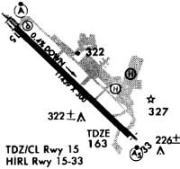
Runways
Runway Summary
| Runways: | 15/33 H1 |
| Longest Runway: | 15/33 is 11440 ft (3487 m) long |
| Runways with an Instrument Approach: | 15, 33 |
BGR Airport Runway Details
| Runway 15/33 | 11440 ft x 200 ft (3487 m x 61 m) | |
| Runway Length Source: | STATE as of 07/24/2004 | |
| Surface: | Asphalt - Good condition - Saw-cut or plastic grooved | |
| Runway Pavement Class: | 120/R/A/W/T | |
| Runway Edge Lights: | High Intensity | |
Runway Weight Bearing Capacity (in thousands of pounds) |
||
| Single Wheel Landing Gear: | 100.0 | |
| Dual Wheel Landing Gear: | 210.0 | |
| Dual Tandem Wheel Landing Gear: | 400.0 | |
Runway 15 |
Runway 33 |
|
Elevation: |
192.1 | 162.9 |
Latitude: |
44-49-06.1369N | 44-47-47.4136N |
Longitude: |
068-50-38.1522W | 068-48-44.3618W |
|
Runway True Alignment: |
134 | 314 |
ILS Type: |
ILS/DME | ILS/DME |
Glide Path Angle: |
3.0 degrees | 3.0 degrees |
Traffic Pattern: |
Left | |
Runway Markings Type: |
Precision Instrument | Precision Instrument |
Runway Markings Condition: |
Good | Good |
Object at End: |
TREES | |
Object Height: |
76 | |
Distance from End: |
2800 | |
Object Centerline Offset: |
0 ft. left and right of centerline | |
Visual Glide Slope Indicators: |
4-Light PAPI On Left Side Of Runway | 4-Light PAPI On Left Side Of Runway |
Runway Visual Range (RVR): |
Touchdown, Midfield, Rollout | Touchdown, Midfield, Rollout |
Approach Light System: |
Standard 2,400 Foot High Intensity Approach Lighting System With Sequenced Flashers, Cat. II or III Config. | 1,400 Foot Medium Intensity Approach Lighting System With Runway Alignment Indicator Lights |
Touchdown Lights: |
Yes | No |
Centerline Lights: |
Yes | Yes |
Threshold Crossing Height: |
55 | 57 |
Declared Distances |
||
Take Off Run Avbl. (TORA): |
11440 | 11440 |
Take Off Distance Avbl. (TODA): |
11440 | 11440 |
Actual Stop Dist. Avbl. (ASDA): |
11440 | 11440 |
Landing Dist. Avbl. (LDA): |
11440 | 11440 |
| Helipad H1 | 100 ft x 100 ft (30 m x 30 m) | |
| Surface: | Asphalt - Good condition - No special surface treatment | |
Helipad H1 |
||
Glide Path Angle: |
0.0 degrees | 0.0 degrees |
Object Centerline Offset: |
0 ft. left and right of centerline |
Services
Bottled Oxygen: |
None |
Bulk Oxygen: |
None |
Fuel Available: |
100LL, Jet A |
Landing Fees: |
No |
Parking: |
Hangars and tiedowns available |
Maps & Diagrams
BGR Sectional
Flight Planning
at skyvector.com
at skyvector.com