Location
Latitude: |
44-34-31.3000N (44.575361) |
Longitude: |
071-10-33.3000W (-71.175917) |
Elevation: |
1161.3 feet MSL (354 m MSL) |
Magnetic Variation: |
14.6 W (as of April 2024 from WMM2020 model) |
Time Zone: |
UTC -5.0 (Standard Time) UTC -4.0 (Daylight Savings Time) |
From City: |
07 N.M. N of Berlin, New Hampshire |
Found On: |
Montreal Chart |
FAA Region: |
ANE |
Contacts
Manager: |
Publicly owned: |
| MARCEL LEVEILLE 800 EAST SIDE RIVER RD. MILAN, NH 03588 603-449-2168 |
CITY OF BERLIN 168 MAIN ST BERLIN, NH 03570 603-752-7532 |
Operations
Airport Status: |
Operational |
Facility Use: |
Public |
Type: |
Airport |
Activation Date: |
12/1946 |
Control tower: |
No |
Attendance (Months/Days/Hours): |
Months/Days/Hours ALL/ALL/0800-1600 |
Boundary ARTCC: |
ZBW (Boston) |
Responsible ARTCC: |
ZBW (Boston) |
Lighting Schedule: |
SEE RMK |
Segmented Circle Indicator: |
No |
Traffic Pattern Altitude (MSL): |
2161 feet (659 m) |
NOTAMs Facility: |
BML |
NOTAM-D Service: |
Yes |
International Airport of Entry: |
No |
Customs Landing Rights: |
No |
Military Landing Rights: |
Yes |
Civil/Military Joint Use: |
No |
Based Aircraft
| Single Engine: | 10 |
| Ultralights: | 1 |
Annual Operations (as of 07/12/2019)
| Total Operations: | 3560 | |
| Air Taxi: | 10 | 0.3% |
| GA Local: | 2000 | 56.2% |
| GA Itinerant: | 1500 | 42.1% |
| Military Aircraft: | 50 | 1.4% |
Communications
| CTAF: | 122.700 |
| Unicom: | 122.700 |
| ASOS: | 135.175 (603-449-3328) |
- APCH/DEP SVC PRVDD BY BOSTON ARTCC ON FREQS 135.7/282.2 (BERLIN RCAG).
Fixed Based Operators (FBOs) & Fuel
(Click on a business for detail)
Please help us keep this information up to date. This is a FREE SERVICE just like everything else on Airport Guide! If you see that a business needs to be added, modified, or deleted please fill out our Update Form.
To add, modify, or delete a business click here.
Please help us keep this information up to date. This is a FREE SERVICE just like everything else on Airport Guide! If you see that a business needs to be added, modified, or deleted please fill out our Update Form.
Area Code: 603 |
| Business Name | Frequency | Phone | Fuel Grade |
|---|---|---|---|
| Shoey Air Corporation
Update FBO info |
Unicom 122.775 | 449-6600 |
Flight Service Stations
| Primary | Alternate | |
| FSS on Field: | N | |
| FSS Name (ID): | Bangor(BGR) | |
| Frequency: | ||
| Toll Free Phone: | 1-800-WX-BRIEF |
Instrument Procedures / Charts
FAA Terminal Procedures valid from 0901Z 03/21/24 to 0901Z 04/18/24.
There are various types of charts available for an airport. They are listed in the Page Type column. Here is a legend for those types:
APD - Airport Diagram
DP - Departure Procedure Charts
HOT - Hot Spots
IAP - Instrument Approach Procedure Charts
MIN - Minimums
STAR - Standard Terminal Arrival Charts
| Page Type | Page Name | Volume | Action Since Last Cycle |
|---|---|---|---|
| IAP | RNAV (GPS) RWY 18 | NE-1 | Changed |
| MIN | ALTERNATE MINIMUMS | NE-1 | |
| MIN | TAKEOFF MINIMUMS | NE-1 |
Terminal Procedures are only available for airports in several countries with more being added all the time. If you are looking for a specific country's charts, please send an email to support(at)airportguide.com stating the country name. This will be used to prioritize the implementation.
Navigation Aids (Navaids) near BML
| Dist (NM) | ID | Morse Code | Name | Type | Freq | True Hdg | Mag Hdg |
|---|---|---|---|---|---|---|---|
| 3.5 | BML | _ . . . _ _ . _ . . | Berlin | DME | 116.55 | 352 | 367 |
| 20.8 | HIE | . . . . . . . | Witey | FAN MARKER | 233 | 248 | |
| 25.3 | GMA | _ _ . _ _ . _ | Mahn | NDB | 386 | 239 | 253 |
| 28.1 | RQM | . _ . _ _ . _ _ _ | Rangeley | NDB | 221 | 39 | 54 |
| 36.7 | LLX | . _ . . . _ . . _ . . _ | Lyndonville | NDB | 353 | 263 | 277 |
| 43.7 | SZO | . . . _ _ . . _ _ _ | Sebago | NDB | 227 | 157 | 172 |
| 51.5 | LE | . _ . . . | Lewie | NDB | 240 | 135 | 150 |
| 51.5 | YSC | _ . _ _ . . . _ . _ . | Sherbrooke | VOR-DME | 113.20 | 329 | 344 |
| 57.1 | AU | . _ . . _ | Dunns | NDB | 366 | 99 | 114 |
| 61.0 | AUG | . _ . . _ _ _ . | Augusta | VOR-DME | 114.95 | 104 | 119 |
| 61.6 | LCI | . _ . . _ . _ . . . | Laconia | FAN MARKER | 190 | 204 | |
| 62.0 | RL | . _ . . _ . . | Bracy | NDB | 399 | 95 | 110 |
| 62.1 | MPV | _ _ . _ _ . . . . _ | Montpelier | VOR-DME | 116.90 | 242 | 256 |
| 64.2 | LC | . _ . . _ . _ . | Blnap | NDB | 328 | 194 | 208 |
| 67.1 | PWM | . _ _ . . _ _ _ _ | Portland | VOT | 111.00 | 145 | 160 |
| 67.9 | LAH | . _ . . . _ . . . . | Hanover | NDB | 276 | 219 | 233 |
| 68.4 | NHZ | _ . . . . . _ _ . . | Brunswick | TACAN | 115.20 | 127 | 142 |
| 70.0 | LEB | . _ . . . _ . . . | Lebanon | DME | 113.7 | 220 | 234 |
| 73.1 | ENE | . _ . . | Kennebunk | VOR-DME | 117.10 | 160 | 175 |
| 77.9 | BUP | _ . . . . . _ . _ _ . | Burnham | NDB | 348 | 83 | 98 |
Nearby Airports with Fuel
Notices to Airmen (NOTAMS)
Remarks
| A110-1 | OBSTN LGTS ON ANT POLES; HAZARD BCNS ON SURROUNDING HILLS. |
| A110-2 | WILDLIFE ON & INVOF ARPT. |
| A110-3 | COLD TEMPERATURE AIRPORT. ALTITUDE CORRECTION REQUIRED AT OR BELOW -29C. |
| A110-4 | FOR CD IF UNA TO CTC ON FSS FREQ, CTC BOSTON ARTCC AT 603-879-6859. |
| A110-5 | RENTAL CARS & CATERING AVBL BY REQ, CALL 603-915-0214. |
| A16 | AMGR AFT HRS FONE 603-915-0214. |
| A24 | CORPORATE AND CHTR ACFT LDG FEE FOR ALL PISTON, TURBOPROP & JET ACFT. LDG FEE WAIVED WITH FUEL PURCHASE & OVNGT PRKG, CORPORATE & CHTR ACFT OVNGT PRKG FEE. CTC AMGR. |
| A70-FUEL-10 | 0LL SELF-SERVE 100LL AVBL 24 HRS WITH CREDIT CARD SYSTEM. FOR JET A AFTER HRS CALL 603-915-0214. |
| A81-APT | ACTVT REIL RWY 18 & 36, PAPI RWY 18, HIRL RWY 18/36 - CTAF. |
| E111 | ESTAB PRIOR 1959 |
Runways
Runway Summary
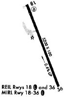
| Runways: | 18/36 |
| Longest Runway: | 18/36 is 5200 ft (1585 m) long |
| Runways with an Instrument Approach: |
BML Airport Runway Details
| Runway 18/36 | 5200 ft x 100 ft (1585 m x 30 m) | |
| Runway Length Source: | 3RD PARTY SURVEY as of 02/27/2010 | |
| Surface: | Asphalt - Good condition - No special surface treatment | |
| Runway Edge Lights: | High Intensity | |
Runway Weight Bearing Capacity (in thousands of pounds) |
||
| Single Wheel Landing Gear: | 53.0 | |
| Dual Wheel Landing Gear: | 82.0 | |
| Dual Tandem Wheel Landing Gear: | 140.0 | |
Runway 18 |
Runway 36 |
|
Elevation: |
1161.3 | 1130.4 |
Latitude: |
44-34-55.3055N | 44-34-07.3452N |
Longitude: |
071-10-46.1690W | 071-10-20.5129W |
|
Runway True Alignment: |
159 | 339 |
Glide Path Angle: |
3.5 degrees | 0.0 degrees |
Traffic Pattern: |
Left | Left |
Runway Markings Type: |
Nonprecision Instrument | Nonprecision Instrument |
Runway Markings Condition: |
Good | Good |
Object at End: |
TREES | TREES |
Object Height: |
55 | 18 |
Distance from End: |
799 | 235 |
Object Centerline Offset: |
290 ft. left of centerline | 235 ft. left of centerline |
Visual Glide Slope Indicators: |
4-Light PAPI On Left Side Of Runway | |
REIL: |
Yes | Yes |
Touchdown Lights: |
No | No |
Centerline Lights: |
No | No |
Threshold Crossing Height: |
65 |
Services
Airframe Repair: |
None |
Powerplant Repair: |
None |
Bottled Oxygen: |
None |
Bulk Oxygen: |
None |
Fuel Available: |
100LL |
Landing Fees: |
No |
Parking: |
Hangars and tiedowns available |
Maps & Diagrams
BML Sectional
Flight Planning
at skyvector.com
at skyvector.com