Location
Latitude: |
44-03-36.5120N (44.060142) |
Longitude: |
069-05-58.8110W (-69.09967) |
Elevation: |
55.4 feet MSL (17 m MSL) |
Magnetic Variation: |
15.2 W (as of April 2024 from WMM2020 model) |
Time Zone: |
UTC -5.0 (Standard Time) UTC -4.0 (Daylight Savings Time) |
From City: |
03 N.M. S of Rockland, Maine |
Found On: |
Montreal Chart |
FAA Region: |
ANE |
Contacts
Manager: |
Publicly owned: |
| JEREMY SHAW 5 AIRPORT RD OWLS HEAD, ME 04854 207-594-4131 |
KNOX COUNTY 62 UNION ST ROCKLAND, ME 04841 207-594-0420 |
Operations
Airport Status: |
Operational |
Facility Use: |
Public |
Type: |
Airport |
Activation Date: |
02/1943 |
Control tower: |
No |
Attendance (Months/Days/Hours): |
Months/Days/Hours ALL/MON-FRI/0600-1700 |
Boundary ARTCC: |
ZBW (Boston) |
Responsible ARTCC: |
ZBW (Boston) |
Lighting Schedule: |
SEE RMK |
Segmented Circle Indicator: |
Yes |
Traffic Pattern Altitude (MSL): |
1055 feet (322 m) |
NOTAMs Facility: |
RKD |
NOTAM-D Service: |
Yes |
International Airport of Entry: |
No |
Customs Landing Rights: |
No |
Military Landing Rights: |
Yes |
Civil/Military Joint Use: |
No |
Based Aircraft
| Single Engine: | 54 |
| Multi Engine: | 1 |
| Jet Engine: | 2 |
| Gliders: | 1 |
Annual Operations (as of 12/31/2022)
| Total Operations: | 17584 | |
| Commercial: | 2596 | 14.8% |
| Air Taxi: | 4791 | 27.2% |
| GA Local: | 4140 | 23.5% |
| GA Itinerant: | 6011 | 34.2% |
| Military Aircraft: | 46 | 0.3% |
Communications
| CTAF: | 123.050 |
| Unicom: | 123.050 |
| Approach: | PORTLAND 120.4 120.4 120.4 BOSTON ARTCC |
| Departure: | PORTLAND 120.4 120.4 120.4 BOSTON ARTCC |
| AWOS-3PT: | 119.025 (207-594-7946) |
- APCH/DEP SVC PRVDD BY BOSTON ARTCC ON FREQS 128.2/263.05 (112-292) (WATERBORO RCAG); FREQS 124.25/290.50 (293-111) (BANGOR RCAG) WHEN PORTLAND APCH CTL CLSD.
Fixed Based Operators (FBOs) & Fuel
(Click on a business for detail)
Please help us keep this information up to date. This is a FREE SERVICE just like everything else on Airport Guide! If you see that a business needs to be added, modified, or deleted please fill out our Update Form.
To add, modify, or delete a business click here.
Please help us keep this information up to date. This is a FREE SERVICE just like everything else on Airport Guide! If you see that a business needs to be added, modified, or deleted please fill out our Update Form.
Area Code: 207 |
| Business Name | Frequency | Phone | Fuel Grade |
|---|---|---|---|
| Downeast Air, Inc.
Update FBO info |
Unicom 122.8 | 594-2171, 888-594-2171 | 100LL, Mogas, Jet A |
| Penobscot Air Services, LTD.
Update FBO info |
Unicom 122.8 | 800-780-6071 | 100LL, Jet A |
Flight Service Stations
| Primary | Alternate | |
| FSS on Field: | N | |
| FSS Name (ID): | Bangor(BGR) | |
| Frequency: | ||
| Toll Free Phone: | 1-800-WX-BRIEF |
Instrument Procedures / Charts
FAA Terminal Procedures valid from 0901Z 03/21/24 to 0901Z 04/18/24.
There are various types of charts available for an airport. They are listed in the Page Type column. Here is a legend for those types:
APD - Airport Diagram
DP - Departure Procedure Charts
HOT - Hot Spots
IAP - Instrument Approach Procedure Charts
MIN - Minimums
STAR - Standard Terminal Arrival Charts
| Page Type | Page Name | Volume | Action Since Last Cycle |
|---|---|---|---|
| IAP | ILS OR LOC RWY 13 | NE-1 | |
| IAP | RNAV (GPS) RWY 03 | NE-1 | |
| IAP | RNAV (GPS) RWY 13 | NE-1 | |
| IAP | RNAV (GPS) RWY 31 | NE-1 | |
| MIN | ALTERNATE MINIMUMS | NE-1 | |
| MIN | TAKEOFF MINIMUMS | NE-1 |
Terminal Procedures are only available for airports in several countries with more being added all the time. If you are looking for a specific country's charts, please send an email to support(at)airportguide.com stating the country name. This will be used to prioritize the implementation.
Navigation Aids (Navaids) near RKD
| Dist (NM) | ID | Morse Code | Name | Type | Freq | True Hdg | Mag Hdg |
|---|---|---|---|---|---|---|---|
| 0.6 | SUH | . . . . . _ . . . . | Sprucehead | NDB | 356 | 200 | 215 |
| 5.5 | RM | . _ . _ _ | Noxks | NDB | 334 | 291 | 306 |
| 21.4 | BST | _ . . . . . . _ | Belfast | NDB | 278 | 10 | 25 |
| 33.8 | AUG | . _ . . _ _ _ . | Augusta | VOR-DME | 114.95 | 297 | 312 |
| 36.3 | RL | . _ . . _ . . | Bracy | NDB | 399 | 311 | 326 |
| 37.2 | NHZ | _ . . . . . _ _ . . | Brunswick | TACAN | 115.20 | 252 | 267 |
| 38.9 | AU | . _ . . _ | Dunns | NDB | 366 | 303 | 318 |
| 39.8 | BUP | _ . . . . . _ . _ _ . | Burnham | NDB | 348 | 343 | 358 |
| 44.5 | BH | _ . . . . . . . | Surry | NDB | 330 | 49 | 64 |
| 45.9 | BGR | _ . . . _ _ . . _ . | Bangor | VOT | 111.00 | 15 | 30 |
| 47.9 | BGR | _ . . . _ _ . . _ . | Bangor | VORTAC | 114.80 | 11 | 26 |
| 53.6 | PH | . _ _ . . . . . | Portland Lhb-P | MARINE NDB | 301 | 233 | 248 |
| 53.8 | LE | . _ . . . | Lewie | NDB | 240 | 264 | 279 |
| 57.9 | PWM | . _ _ . . _ _ _ _ | Portland | VOT | 111.00 | 245 | 260 |
| 60.1 | OLD | _ _ _ . _ . . _ . . | Old Town | NDB | 272 | 19 | 34 |
| 73.2 | SZO | . . . _ _ . . _ _ _ | Sebago | NDB | 227 | 263 | 278 |
| 75.9 | ENE | . _ . . | Kennebunk | VOR-DME | 117.10 | 240 | 255 |
| 88.0 | RQM | . _ . _ _ . _ _ _ | Rangeley | NDB | 221 | 307 | 322 |
| 90.4 | ESG | . . . . _ _ . | Rollins | NDB | 260 | 236 | 251 |
| 94.9 | MLT | _ _ . _ . . _ | Millinocket | VOR-DME | 117.90 | 14 | 29 |
Nearby Airports with Fuel
Notices to Airmen (NOTAMS)
Remarks
| A110-1 | DEER & SEAGULLS ON & INVOF ARPT. |
| A110-2 | VOLUNTARY NGT CUFREW IN EFCT 2230-0600. |
| A110-3 | NOISE ABATEMENT PROCS IN EFCT, CALL 207-596-0617 OR VISIT WEBSITE FOR SPECIFIC INSTRUCTIONS. |
| A110-4 | FOR CD WHEN APCH CLSD CTC BOSTON ARTCC AT 603-879-6859. |
| A17 | ARPT MAY BE UNATNDD FM 2200-0600. |
| A75 | CALL FBO 207-594-2171 FOR AVBL. |
| A81-APT | ACTVT MALSR RWY 13; REIL RWY 03 & 31; PAPI RWY 03, 13 & 31; HIRL RWY 13/31; MIRL RWY 03/21 - CTAF. |
| E111 | EXISTED PRIOR TO 1959. |
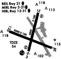
Runways
Runway Summary
| Runways: | 03/21 13/31 |
| Longest Runway: | 13/31 is 5412 ft (1650 m) long |
| Runways with an Instrument Approach: | 13 |
RKD Seaplane Base Runway Details
| Runway 03/21 | 4000 ft x 100 ft (1219 m x 30 m) | |
| Runway Length Source: | FAA as of 01/19/2005 | |
| Surface: | Asphalt - Good condition - No special surface treatment | |
| Runway Edge Lights: | Medium Intensity | |
Runway Weight Bearing Capacity (in thousands of pounds) |
||
| Single Wheel Landing Gear: | 65.0 | |
| Dual Wheel Landing Gear: | 80.0 | |
Runway 03 |
Runway 21 |
|
Elevation: |
50.2 | 55.1 |
Latitude: |
44-03-21.5900N | 44-04-00.0100N |
Longitude: |
069-06-02.6900W | 069-05-49.9700W |
|
Runway True Alignment: |
013 | 193 |
Glide Path Angle: |
3.0 degrees | 0.0 degrees |
Traffic Pattern: |
Left | Left |
Runway Markings Type: |
Nonprecision Instrument | Nonprecision Instrument |
Runway Markings Condition: |
Good | Good |
Object at End: |
TREES | TREES |
Object Height: |
26 | 50 |
Distance from End: |
357 | 525 |
Object Centerline Offset: |
270 ft. right of centerline | 250 ft. left of centerline |
Visual Glide Slope Indicators: |
4-Light PAPI On Left Side Of Runway | |
REIL: |
Yes | |
Touchdown Lights: |
No | No |
Centerline Lights: |
No | No |
Threshold Crossing Height: |
34 | |
Declared Distances |
||
Take Off Run Avbl. (TORA): |
4000 | 4000 |
Take Off Distance Avbl. (TODA): |
4000 | 4000 |
Actual Stop Dist. Avbl. (ASDA): |
4000 | 4000 |
Landing Dist. Avbl. (LDA): |
4000 | 4000 |
| Runway 13/31 | 5412 ft x 100 ft (1650 m x 30 m) | |
| Runway Length Source: | FAA as of 08/22/2018 | |
| Surface: | Asphalt - Good condition - Saw-cut or plastic grooved | |
| Runway Edge Lights: | High Intensity | |
Runway Weight Bearing Capacity (in thousands of pounds) |
||
| Single Wheel Landing Gear: | 65.0 | |
| Dual Wheel Landing Gear: | 80.0 | |
Runway 13 |
Runway 31 |
|
Elevation: |
45.6 | 54.7 |
Latitude: |
44-03-42.8838N | 44-03-23.7971N |
Longitude: |
069-06-35.2592W | 069-05-26.0336W |
|
Runway True Alignment: |
111 | 291 |
ILS Type: |
ILS/DME | |
Glide Path Angle: |
3.0 degrees | 3.0 degrees |
Traffic Pattern: |
Left | Left |
Runway Markings Type: |
Precision Instrument | Precision Instrument |
Runway Markings Condition: |
Good | Good |
Object at End: |
TREES | |
Object Height: |
40 | |
Distance from End: |
450 | |
Object Centerline Offset: |
270 ft. right of centerline | 250 ft. left of centerline |
Visual Glide Slope Indicators: |
4-Light PAPI On Right Side Of Runway | 4-Light PAPI On Left Side Of Runway |
Approach Light System: |
1,400 Foot Medium Intensity Approach Lighting System With Runway Alignment Indicator Lights | |
REIL: |
No | Yes |
Touchdown Lights: |
No | No |
Centerline Lights: |
No | No |
Threshold Crossing Height: |
51 | 50 |
Threshold Elevation: |
45.6 | |
Displaced Threshold: |
400 | |
Threshold Latitude: |
44-03-41.4749N | |
Threshold Longitude: |
069-06-30.1497W | |
Declared Distances |
||
Take Off Run Avbl. (TORA): |
5412 | 5412 |
Take Off Distance Avbl. (TODA): |
5412 | 5412 |
Actual Stop Dist. Avbl. (ASDA): |
5412 | 5412 |
Landing Dist. Avbl. (LDA): |
5012 | 5412 |
Services
Fuel Available: |
100LL |
Maps & Diagrams
RKD Sectional
Flight Planning
at skyvector.com
at skyvector.com