Location
Latitude: |
44-02-54.5020N (44.048473) |
Longitude: |
070-17-00.6270W (-70.283508) |
Elevation: |
287.5 feet MSL (88 m MSL) |
Magnetic Variation: |
14.8 W (as of April 2024 from WMM2020 model) |
Time Zone: |
UTC -5.0 (Standard Time) UTC -4.0 (Daylight Savings Time) |
From City: |
04 N.M. SW of Auburn/Lewiston, Maine |
Found On: |
Montreal Chart |
FAA Region: |
ANE |
Contacts
Manager: |
Publicly owned: |
| JONATHAN LABONTE 80 AIRPORT DR AUBURN, ME 04210 207-786-0631 |
CITIES OF AUBURN & LEWISTON 80 AIRPORT DR AUBURN, ME 04210 207-786-0631 |
Operations
Airport Status: |
Operational |
Facility Use: |
Public |
Type: |
Airport |
Activation Date: |
04/1940 |
Control tower: |
No |
Attendance (Months/Days/Hours): |
Months/Days/Hours ALL/ALL/0800-1700 |
Boundary ARTCC: |
ZBW (Boston) |
Responsible ARTCC: |
ZBW (Boston) |
Lighting Schedule: |
SEE RMK |
Segmented Circle Indicator: |
Yes |
Traffic Pattern Altitude (MSL): |
1288 feet (393 m) |
NOTAMs Facility: |
LEW |
NOTAM-D Service: |
Yes |
Based Aircraft
| Single Engine: | 56 |
| Multi Engine: | 10 |
| Jet Engine: | 1 |
| GA Helicopters: | 5 |
Annual Operations (as of 08/19/2020)
| Total Operations: | 50000 | |
| Air Taxi: | 14000 | 28.0% |
| GA Local: | 20000 | 40.0% |
| GA Itinerant: | 15900 | 31.8% |
| Military Aircraft: | 100 | 0.2% |
Communications
| CTAF: | 122.800 |
| Unicom: | 122.800 |
| Approach: | PORTLAND BOSTON ARTCC |
| Departure: | PORTLAND BOSTON ARTCC |
| AWOS-3PT: | 118.025 (207-783-2806) |
- APCH/DEP SVC PRVDD BY BOSTON ARTCC ON FREQS 128.2 (WATERBORO RCAG) AND 290.50 (BANGOR RCAG) WHEN PORTLAND ATCT CLSD.
Fixed Based Operators (FBOs) & Fuel
(Click on a business for detail)
Please help us keep this information up to date. This is a FREE SERVICE just like everything else on Airport Guide! If you see that a business needs to be added, modified, or deleted please fill out our Update Form.
To add, modify, or delete a business click here.
Please help us keep this information up to date. This is a FREE SERVICE just like everything else on Airport Guide! If you see that a business needs to be added, modified, or deleted please fill out our Update Form.
Area Code: 207 |
| Business Name | Frequency | Phone | Fuel Grade |
|---|---|---|---|
| Skyward Aviation
Update FBO info |
786-9303 | ||
| Twin Cities Air Service
Update FBO info |
Unicom 122.8 | 784-6318 | 100LL, Jet A |
Flight Service Stations
| Primary | Alternate | |
| FSS on Field: | N | |
| FSS Name (ID): | Bangor(BGR) | |
| Frequency: | ||
| Toll Free Phone: | 1-800-WX-BRIEF |
Instrument Procedures / Charts
FAA Terminal Procedures valid from 0901Z 03/21/24 to 0901Z 04/18/24.
There are various types of charts available for an airport. They are listed in the Page Type column. Here is a legend for those types:
APD - Airport Diagram
DP - Departure Procedure Charts
HOT - Hot Spots
IAP - Instrument Approach Procedure Charts
MIN - Minimums
STAR - Standard Terminal Arrival Charts
| Page Type | Page Name | Volume | Action Since Last Cycle |
|---|---|---|---|
| IAP | ILS OR LOC RWY 04 | NE-1 | |
| IAP | RNAV (GPS) RWY 04 | NE-1 | |
| IAP | RNAV (GPS) RWY 22 | NE-1 | |
| MIN | ALTERNATE MINIMUMS | NE-1 | |
| MIN | TAKEOFF MINIMUMS | NE-1 |
Terminal Procedures are only available for airports in several countries with more being added all the time. If you are looking for a specific country's charts, please send an email to support(at)airportguide.com stating the country name. This will be used to prioritize the implementation.
Navigation Aids (Navaids) near LEW
| Dist (NM) | ID | Morse Code | Name | Type | Freq | True Hdg | Mag Hdg |
|---|---|---|---|---|---|---|---|
| 5.7 | LE | . _ . . . | Lewie | NDB | 240 | 204 | 219 |
| 18.8 | NHZ | _ . . . . . _ _ . . | Brunswick | TACAN | 115.20 | 123 | 138 |
| 23.2 | SZO | . . . _ _ . . _ _ _ | Sebago | NDB | 227 | 248 | 263 |
| 24.1 | PWM | . _ _ . . _ _ _ _ | Portland | VOT | 111.00 | 182 | 197 |
| 26.5 | AUG | . _ . . _ _ _ . | Augusta | VOR-DME | 114.95 | 51 | 66 |
| 28.3 | AU | . _ . . _ | Dunns | NDB | 366 | 39 | 54 |
| 32.4 | PH | . _ _ . . . . . | Portland Lhb-P | MARINE NDB | 301 | 165 | 180 |
| 34.1 | RL | . _ . . _ . . | Bracy | NDB | 399 | 43 | 58 |
| 40.0 | ENE | . _ . . | Kennebunk | VOR-DME | 117.10 | 201 | 216 |
| 46.0 | RM | . _ . _ _ | Noxks | NDB | 334 | 86 | 101 |
| 50.8 | SUH | . . . . . _ . . . . | Sprucehead | NDB | 356 | 89 | 104 |
| 52.3 | BML | _ . . . _ _ . _ . . | Berlin | DME | 116.55 | 312 | 327 |
| 55.0 | ESG | . . . . _ _ . | Rollins | NDB | 260 | 205 | 220 |
| 55.6 | BUP | _ . . . . . _ . _ _ . | Burnham | NDB | 348 | 45 | 60 |
| 56.8 | RQM | . _ . _ _ . _ _ _ | Rangeley | NDB | 221 | 339 | 354 |
| 57.8 | LCI | . _ . . _ . _ . . . | Laconia | FAN MARKER | 240 | 255 | |
| 58.3 | HIE | . . . . . . . | Witey | FAN MARKER | 289 | 304 | |
| 58.9 | BST | _ . . . . . . _ | Belfast | NDB | 278 | 67 | 82 |
| 62.4 | LC | . _ . . _ . _ . | Blnap | NDB | 328 | 240 | 255 |
| 62.6 | PSM | . _ _ . . . . _ _ | Pease | DME | 116.5 | 202 | 217 |
Nearby Airports with Fuel
Notices to Airmen (NOTAMS)
Remarks
| A110*G | THIS AIRPORT HAS BEEN SURVEYED BY THE NATIONAL GEODETIC SURVEY. |
| A110-1 | BIRDS ON & INVOF ARPT. |
| A110-2 | RWY 04 DSGND CALM WIND RWY. |
| A110-3 | OCNL BLASTING IN PROG MON-SAT APRXLY 4800-5000 FT SW OF RWY 04 THR 1100-1500 DURG VFR CONDS ONLY. |
| A110-5 | INTENSIVE HOP DLY FM 0500-2000. HEL TFC PAT 500 AGL, RIGHT TFC. |
| A110-6 | ACFT DE-ICING AVBL. |
| A110-7 | FOR CD WHEN APCH CLSD CTC BOSTON ARTCC AT 603-879-6859. |
| A14 | AUBURN CITY TRANSPORTATION DIR. |
| A58-22 | 13 FT POLE 100 FT FM RWY END, 375 FT R, +5 FT ROADWAY 0-200 FT FM RWY END 0-350 FT R. |
| A70-FUEL-10 | 0LL FOR FUEL OR SVCS AFT HRS CALL 207-784-6318. |
| A75 | CALL AHD FOR AVBLTY. |
| A81-APT | ACTVT MALSR RWY 04; REIL RWY 22; HIRL RWY 04/22 & MIRL RWY 17/35 - CTAF. |
| E111 | EXISTED PRIOR TO 1959. |
Runways
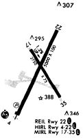
Runway Summary
| Runways: | 04/22 17/35 |
| Longest Runway: | 04/22 is 5001 ft (1524 m) long |
| Runways with an Instrument Approach: | 04 |
LEW Airport Runway Details
| Runway 04/22 | 5001 ft x 100 ft (1524 m x 30 m) | |
| Runway Length Source: | NGS as of 06/06/1999 | |
| Surface: | Asphalt - Excellent condition - Saw-cut or plastic grooved | |
| Runway Edge Lights: | High Intensity | |
Runway Weight Bearing Capacity (in thousands of pounds) |
||
| Single Wheel Landing Gear: | 30.0 | |
| Dual Wheel Landing Gear: | 108.0 | |
| Dual Tandem Wheel Landing Gear: | 180.0 | |
Runway 04 |
Runway 22 |
|
Elevation: |
270.4 | 263.1 |
Latitude: |
44-02-32.0609N | 44-03-17.0375N |
Longitude: |
070-17-17.0073W | 070-16-48.7404W |
|
Runway True Alignment: |
024 | 204 |
ILS Type: |
ILS/DME | |
Glide Path Angle: |
3.0 degrees | 3.5 degrees |
Traffic Pattern: |
Left | Left |
Runway Markings Type: |
Precision Instrument | Nonprecision Instrument |
Runway Markings Condition: |
Good | Good |
Object at End: |
TREES | TREES |
Object Height: |
100 | 62 |
Distance from End: |
4450 | 849 |
Object Centerline Offset: |
450 ft. right of centerline | 340 ft. right of centerline |
Visual Glide Slope Indicators: |
4-Light PAPI On Left Side Of Runway | 4-Light PAPI On Left Side Of Runway |
Approach Light System: |
1,400 Foot Medium Intensity Approach Lighting System With Runway Alignment Indicator Lights | |
REIL: |
No | Yes |
Touchdown Lights: |
No | No |
Centerline Lights: |
No | No |
Threshold Crossing Height: |
49 | 35 |
| Runway 17/35 | 2750 ft x 75 ft (838 m x 23 m) | |
| Runway Length Source: | NGS as of 06/15/1993 | |
| Surface: | Asphalt - Excellent condition - No special surface treatment | |
| Runway Edge Lights: | Medium Intensity | |
Runway Weight Bearing Capacity (in thousands of pounds) |
||
| Single Wheel Landing Gear: | 30.0 | |
Runway 17 |
Runway 35 |
|
Elevation: |
255.5 | 287.5 |
Latitude: |
44-03-05.8892N | 44-02-42.8919N |
Longitude: |
070-17-06.5343W | 070-16-46.5057W |
|
Runway True Alignment: |
148 | 328 |
Glide Path Angle: |
0.0 degrees | 0.0 degrees |
Traffic Pattern: |
Left | Left |
Runway Markings Type: |
Basic | Basic |
Runway Markings Condition: |
Good | Good |
Object at End: |
TREE | TREE |
Object Height: |
73 | 58 |
Distance from End: |
1508 | 1077 |
Object Centerline Offset: |
450 ft. right of centerline | 340 ft. right of centerline |
REIL: |
No | No |
Touchdown Lights: |
No | No |
Centerline Lights: |
No | No |
Services
Airframe Repair: |
None |
Powerplant Repair: |
None |
Bottled Oxygen: |
None |
Bulk Oxygen: |
None |
Fuel Available: |
100LL, Jet A+ |
Landing Fees: |
No |
Parking: |
Hangars and tiedowns available |
Maps & Diagrams
LEW Sectional
Flight Planning
at skyvector.com
at skyvector.com