Location
Latitude: |
43-38-44.3166N (43.645643) |
Longitude: |
070-18-31.0189W (-70.308616) |
Elevation: |
75.7 feet MSL (23 m MSL) |
Magnetic Variation: |
14.7 W (as of April 2024 from WMM2020 model) |
Time Zone: |
UTC -5.0 (Standard Time) UTC -4.0 (Daylight Savings Time) |
From City: |
02 N.M. W of Portland, Maine |
Found On: |
New York Chart |
FAA Region: |
ANE |
Contacts
Manager: |
Publicly owned: |
| PAUL BRADBURY 1001 WESTBROOK ST. PORTLAND, ME 04102 207-756-8310 |
CITY OF PORTLAND CITY HALL, 389 CONGRESS ST PORTLAND, ME 04101 207-874-8300 |
Operations
Airport Status: |
Operational |
Facility Use: |
Public |
Type: |
Airport |
Activation Date: |
04/1940 |
Control tower: |
Yes |
Attendance (Months/Days/Hours): |
Months/Days/Hours ALL/ALL/0600-2200 |
Boundary ARTCC: |
ZBW (Boston) |
Responsible ARTCC: |
ZBW (Boston) |
Lighting Schedule: |
SEE RMK |
Segmented Circle Indicator: |
No |
Traffic Pattern Altitude (MSL): |
1076 feet (328 m) |
NOTAMs Facility: |
PWM |
NOTAM-D Service: |
Yes |
International Airport of Entry: |
No |
Customs Landing Rights: |
Yes |
Military Landing Rights: |
Yes |
Civil/Military Joint Use: |
No |
Aircraft Rescue and Firefighting: |
Class I ARFF Index: C Air Carrier Service: Scheduled Certification Date: 05/1973 |
Based Aircraft
| Single Engine: | 29 |
| Multi Engine: | 1 |
| Jet Engine: | 5 |
Annual Operations (as of 06/19/2023)
| Total Operations: | 56092 | |
| Commercial: | 23558 | 42.0% |
| Air Taxi: | 9810 | 17.5% |
| GA Local: | 3700 | 6.6% |
| GA Itinerant: | 17916 | 31.9% |
| Military Aircraft: | 1108 | 2.0% |
Communications
| CTAF: | 120.900 |
| Unicom: | 122.950 |
| Tower: | PORTLAND 120.9 257.8 Hrs: 0545-0000 |
| Clearance Del.: | 121.9 |
| Ground: | 121.9 |
| Approach: | PORTLAND 119.75 269.35 Hrs: 0545-0000 BOSTON ARTCC 132.4 Hrs: 0000-0545 |
| Departure: | PORTLAND 119.75 269.35 Hrs: 0545-0000 BOSTON ARTCC 132.4 Hrs: 0000-0545 |
| ATIS: | 119.05 Hrs: 24 |
| ASOS: | 119.05 (207-874-7914) |
| EMERG: | 243.0 |
| CLASS C: | 119.75 |
| VFR ADZY: | 120.9 |
| CLASS C: | 269.35 |
| EMERG: | 121.5 |
| CLASS C: | 353.9 |
| CLASS C: | 125.5 |
- ATCT OCCASIONALLY STAYS OPEN BYD 0000 LCL DURG ADVERSE WEATHER.
- APCH/DEP SVC PRVDD BY BOSTON ARTCC ON FREQS 128.2/263.05 (WATERBORO RCAG) WHEN PORTLAND APCH CTL CLSD.
Fixed Based Operators (FBOs) & Fuel
(Click on a business for detail)
Please help us keep this information up to date. This is a FREE SERVICE just like everything else on Airport Guide! If you see that a business needs to be added, modified, or deleted please fill out our Update Form.
To add, modify, or delete a business click here.
Please help us keep this information up to date. This is a FREE SERVICE just like everything else on Airport Guide! If you see that a business needs to be added, modified, or deleted please fill out our Update Form.
Area Code: 207 |
| Business Name | Frequency | Phone | Fuel Grade |
|---|---|---|---|
| Irving Aviation Services
Update FBO info |
Unicom 123.50 | 775-5635 | 100LL, Jet A |
| Northeast Air, Inc.
Update FBO info |
Unicom 122.95 | 774-6318 | 100LL, Jet A |
Flight Service Stations
| Primary | Alternate | |
| FSS on Field: | N | |
| FSS Name (ID): | Bangor(BGR) | |
| Frequency: | ||
| Toll Free Phone: | 1-800-WX-BRIEF |
Instrument Procedures / Charts
FAA Terminal Procedures valid from 0901Z 03/21/24 to 0901Z 04/18/24.
There are various types of charts available for an airport. They are listed in the Page Type column. Here is a legend for those types:
APD - Airport Diagram
DP - Departure Procedure Charts
HOT - Hot Spots
IAP - Instrument Approach Procedure Charts
MIN - Minimums
STAR - Standard Terminal Arrival Charts
| Page Type | Page Name | Volume | Action Since Last Cycle |
|---|---|---|---|
| APD | AIRPORT DIAGRAM | NE-1 | |
| DP | HSKEL THREE (RNAV) | NE-1 | |
| DP | NUBLE FOUR (RNAV) | NE-1 | |
| DP | PORTLAND SIX | NE-1 | |
| HOT | HOT SPOT | NE-1 | |
| IAP | HARBOR VISUAL RWY 29 | NE-1 | |
| IAP | ILS OR LOC RWY 11 | NE-1 | |
| IAP | ILS OR LOC RWY 29 | NE-1 | |
| IAP | ILS RWY 11 (CAT II - III) | NE-1 | |
| IAP | ILS RWY 11 (SA CAT I) | NE-1 | |
| IAP | ILS RWY 29 (SA CAT I - II) | NE-1 | |
| IAP | RNAV (GPS) RWY 11 | NE-1 | |
| IAP | RNAV (GPS) RWY 18 | NE-1 | |
| IAP | RNAV (GPS) RWY 29 | NE-1 | |
| IAP | RNAV (GPS) RWY 36 | NE-1 | |
| LAH | LAHSO | NE-1 | |
| MIN | ALTERNATE MINIMUMS | NE-1 | |
| MIN | TAKEOFF MINIMUMS | NE-1 | |
| STAR | CDOGG FOUR (RNAV) | NE-1 | |
| STAR | SCOGS THREE (RNAV) | NE-1 |
Terminal Procedures are only available for airports in several countries with more being added all the time. If you are looking for a specific country's charts, please send an email to support(at)airportguide.com stating the country name. This will be used to prioritize the implementation.
Navigation Aids (Navaids) near PWM
| Dist (NM) | ID | Morse Code | Name | Type | Freq | True Hdg | Mag Hdg |
|---|---|---|---|---|---|---|---|
| 0.1 | PWM | . _ _ . . _ _ _ _ | Portland | VOT | 111.00 | 23 | 38 |
| 11.8 | PH | . _ _ . . . . . | Portland Lhb-P | MARINE NDB | 301 | 126 | 141 |
| 18.7 | ENE | . _ . . | Kennebunk | VOR-DME | 117.10 | 225 | 240 |
| 19.0 | LE | . _ . . . | Lewie | NDB | 240 | 356 | 371 |
| 21.6 | NHZ | _ . . . . . _ _ . . | Brunswick | TACAN | 115.20 | 50 | 65 |
| 25.7 | SZO | . . . _ _ . . _ _ _ | Sebago | NDB | 227 | 307 | 322 |
| 34.1 | ESG | . . . . _ _ . | Rollins | NDB | 260 | 221 | 236 |
| 40.7 | PSM | . _ _ . . . . _ _ | Pease | DME | 116.5 | 214 | 229 |
| 46.1 | AUG | . _ . . _ _ _ . | Augusta | VOR-DME | 114.95 | 28 | 43 |
| 49.4 | LCI | . _ . . _ . _ . . . | Laconia | FAN MARKER | 264 | 278 | |
| 49.8 | AU | . _ . . _ | Dunns | NDB | 366 | 22 | 37 |
| 53.8 | LC | . _ . . _ . _ . | Blnap | NDB | 328 | 263 | 277 |
| 54.3 | RM | . _ . _ _ | Noxks | NDB | 334 | 59 | 74 |
| 54.8 | RL | . _ . . _ . . | Bracy | NDB | 399 | 26 | 41 |
| 57.5 | SUH | . . . . . _ . . . . | Sprucehead | NDB | 356 | 64 | 79 |
| 59.0 | CO | _ . _ . _ _ _ | Epsom | NDB | 216 | 238 | 252 |
| 60.8 | CON | _ . _ . _ _ _ _ . | Concord | VOR-DME | 112.90 | 245 | 259 |
| 64.3 | LWM | . _ . . . _ _ _ _ | Lawrence | DME | 112.5 | 212 | 226 |
| 65.8 | MHT | _ _ . . . . _ | Manchester | VOR-DME | 114.40 | 225 | 239 |
| 68.0 | BVY | _ . . . . . . _ _ . _ _ | Beverly | FAN MARKER | 204 | 218 |
Nearby Airports with Fuel
Notices to Airmen (NOTAMS)
Remarks
| A110-1 | NO TGLS DURG SNOW REMOVAL. |
| A110-10 | BIRDS OCNLY ON & INVOF ARPT. |
| A110-11 | PUSHBACK ONTO TWY A RQRD FM TRML GATES 1-8, TWY C RQRD FM TRML GATE 1A. ACFT MAY NOT PUSH SHORT OF TWY A FM GATES 1-8 NOR SHORT OF TWY C FM GATE 1A. CTC GND 121.9. ADZ PUSHBACK OPR YOU HAVE ALPHA OR CHARLIE PRIOR TO PUSH. |
| A110-12 | FOR CD WHEN ATCT CLSD, CTC BOSTON ARTCC AT 603-879-6859. |
| A110-13 | NOISE ABATEMENT PROCS IN AFCT FOR LDG RWY 11 & DEP RWY 29. |
| A110-7 | PAEW ADJ TO RWYS NGTS; GND VEHICLES MONITOR 120.9 WHEN ATCT CLSD. |
| A110-8 | PRIOR TO ANY RUN-UP CTC ARPT OPS ON FREQ 129.95 OR CALL 207-756-8310. |
| A110-9 | ACFT EMERGS BTN 0000-0545 CALL PORTLAND AIR RESCUE 207-874-8576. |
| A49-11 | ALSF-II BECOMES SSALS WHEN ATCT CLSD. |
| A70-FUEL-10 | 0LL FOR FUEL AFT HRS CALL 207-774-6318 OR 207-523-0988. |
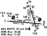
| A81-APT | WHEN TWR CLSD ACTVT MALSR RWY 29; REIL RWY 18 & 36; TDZL RWY 11; CNTLN RWY 11/29; PAPI RWY 11, 29, 18 & 36; HIRL RWY 11/29; MIRL RWY 18/36 - CTAF. |
| E111 | EXISTED PRIOR TO 1959. |
| E80 | GA CUST/IMG FAC LCTD AT CARGO APRON. ACFT ARRG/DEPG CUST MUST USE EXTREME CTN WHEN NAVIGATING ON THE CARGO APRON TO MINIMIZE JET BLAST EXPOSURE TO HNGRS & ACFT. |
Runways
Runway Summary
| Runways: | 11/29 18/36 |
| Longest Runway: | 11/29 is 7200 ft (2195 m) long |
| Runways with an Instrument Approach: | 11, 29 |
PWM Airport Runway Details
| Runway 11/29 | 7200 ft x 150 ft (2195 m x 46 m) | |
| Runway Length Source: | 3RD PARTY SURVEY as of 11/13/2012 | |
| Surface: | Asphalt - Excellent condition - Saw-cut or plastic grooved | |
| Runway Pavement Class: | 96 /F/C/X/T | |
| Runway Edge Lights: | High Intensity | |
Runway Weight Bearing Capacity (in thousands of pounds) |
||
| Single Wheel Landing Gear: | 75.0 | |
| Dual Wheel Landing Gear: | 169.0 | |
| Dual Tandem Wheel Landing Gear: | 300.0 | |
Runway 11 |
Runway 29 |
|
Elevation: |
75.7 | 42.2 |
Latitude: |
43-38-45.1032N | 43-38-38.5209N |
Longitude: |
070-19-33.8651W | 070-17-56.3694W |
|
Runway True Alignment: |
095 | 275 |
ILS Type: |
ILS/DME | ILS/DME |
Glide Path Angle: |
3.0 degrees | 3.0 degrees |
Traffic Pattern: |
Left | Left |
Runway Markings Type: |
Precision Instrument | Precision Instrument |
Runway Markings Condition: |
Good | Good |
Object at End: |
TREES | TREE |
Object Height: |
42 | 166 |
Distance from End: |
2000 | 6400 |
Object Centerline Offset: |
675 ft. right of centerline | 1100 ft. right of centerline |
Visual Glide Slope Indicators: |
4-Light PAPI On Right Side Of Runway | 4-Light PAPI On Right Side Of Runway |
Runway Visual Range (RVR): |
Touchdown, Midfield, Rollout | Touchdown, Midfield, Rollout |
Approach Light System: |
Standard 2,400 Foot High Intensity Approach Lighting System With Sequenced Flashers, Cat. II or III Config. | 1,400 Foot Medium Intensity Approach Lighting System With Runway Alignment Indicator Lights |
REIL: |
No | No |
Touchdown Lights: |
Yes | No |
Centerline Lights: |
Yes | Yes |
Threshold Crossing Height: |
52 | 50 |
Declared Distances |
||
Take Off Run Avbl. (TORA): |
7200 | 7200 |
Take Off Distance Avbl. (TODA): |
7200 | 7200 |
Actual Stop Dist. Avbl. (ASDA): |
7200 | 7200 |
Landing Dist. Avbl. (LDA): |
7200 | 7200 |
| Runway 18/36 | 6100 ft x 150 ft (1859 m x 46 m) | |
| Runway Length Source: | 3RD PARTY SURVEY as of 11/13/2012 | |
| Surface: | Asphalt - Excellent condition - Saw-cut or plastic grooved | |
| Runway Pavement Class: | 91 /F/C/X/T | |
| Runway Edge Lights: | Medium Intensity | |
Runway Weight Bearing Capacity (in thousands of pounds) |
||
| Single Wheel Landing Gear: | 75.0 | |
| Dual Wheel Landing Gear: | 165.0 | |
| Dual Tandem Wheel Landing Gear: | 300.0 | |
Runway 18 |
Runway 36 |
|
Elevation: |
44.8 | 44.3 |
Latitude: |
43-39-16.1036N | 43-38-18.4236N |
Longitude: |
070-18-26.3497W | 070-18-02.3920W |
|
Runway True Alignment: |
163 | 343 |
Glide Path Angle: |
3.0 degrees | 3.2 degrees |
Traffic Pattern: |
Left | Left |
Runway Markings Type: |
Nonprecision Instrument | Nonprecision Instrument |
Runway Markings Condition: |
Good | Good |
Object at End: |
TREE | TREE |
Object Height: |
20 | 60 |
Distance from End: |
600 | 1300 |
Object Centerline Offset: |
675 ft. right of centerline | 1100 ft. right of centerline |
Visual Glide Slope Indicators: |
4-Light PAPI On Left Side Of Runway | 4-Light PAPI On Left Side Of Runway |
REIL: |
Yes | Yes |
Touchdown Lights: |
No | No |
Centerline Lights: |
No | No |
Threshold Crossing Height: |
50 | 54 |
Threshold Elevation: |
47.6 | 45.5 |
Displaced Threshold: |
450 | 500 |
Threshold Latitude: |
43-39-11.8480N | 43-38-23.1523N |
Threshold Longitude: |
070-18-24.5829W | 070-18-04.3547W |
Declared Distances |
||
Take Off Run Avbl. (TORA): |
6100 | 6100 |
Take Off Distance Avbl. (TODA): |
6100 | 6100 |
Actual Stop Dist. Avbl. (ASDA): |
5600 | 5650 |
Landing Dist. Avbl. (LDA): |
5150 | 5150 |
Services
Airframe Repair: |
Major |
Powerplant Repair: |
Major |
Fuel Available: |
100LL |
Landing Fees: |
Yes |
Parking: |
Tiedowns available |
Maps & Diagrams
PWM Sectional
Flight Planning
at skyvector.com
at skyvector.com