Location
Latitude: |
39-47-43.4000N (39.795389) |
Longitude: |
121-51-30.3000W (-121.858417) |
Elevation: |
240.2 feet MSL (73 m MSL) |
Magnetic Variation: |
13.4 E (as of April 2024 from WMM2020 model) |
Time Zone: |
UTC -8.0 (Standard Time) UTC -7.0 (Daylight Savings Time) |
From City: |
04 N.M. N of Chico, California |
Found On: |
San Francisco Chart |
FAA Region: |
AWP |
Contacts
Manager: |
Publicly owned: |
| TOM BAHR 150 AIRPARK BLVD., SUITE 110 CHICO, CA 95973 530-896-7216 |
CITY OF CHICO PO BOX 3420 CHICO, CA 95927 530-896-7200 |
Operations
Airport Status: |
Operational |
Facility Use: |
Public |
Type: |
Airport |
Activation Date: |
04/1987 |
Control tower: |
Yes |
Attendance (Months/Days/Hours): |
Months/Days/Hours ALL/ALL/0700-1900 |
Boundary ARTCC: |
ZOA (Oakland) |
Responsible ARTCC: |
ZOA (Oakland) |
Lighting Schedule: |
SEE RMK |
Segmented Circle Indicator: |
Yes |
Traffic Pattern Altitude (MSL): |
1240 feet (378 m) |
NOTAMs Facility: |
CIC |
NOTAM-D Service: |
Yes |
International Airport of Entry: |
No |
Customs Landing Rights: |
No |
Military Landing Rights: |
Yes |
Civil/Military Joint Use: |
No |
Aircraft Rescue and Firefighting: |
Class III ARFF Index: A Air Carrier Service: Not Scheduled Certification Date: 05/1973 |
Based Aircraft
| Single Engine: | 80 |
| Multi Engine: | 11 |
| Jet Engine: | 2 |
| GA Helicopters: | 5 |
Annual Operations (as of 01/06/2023)
| Total Operations: | 34000 | |
| Commercial: | 21 | 0.1% |
| Air Taxi: | 6719 | 19.8% |
| GA Local: | 6170 | 18.1% |
| GA Itinerant: | 19546 | 57.5% |
| Military Aircraft: | 1544 | 4.5% |
Communications
| CTAF: | 121.000 |
| Unicom: | 122.950 |
| Tower: | CHICO 121.0 239.3 Hrs: 0700-1900 |
| Ground: | 121.9 |
| Approach: | OAKLAND ARTCC |
| Departure: | OAKLAND ARTCC |
| ATIS: | 119.675 Hrs: 24 |
| AWOS-3: | 119.675 (530-879-3850) |
- APCH/DEP CTL SVC PRVDD BY OAKLAND ARTCC (ZOA) ON FREQS 132.2/350.3 (RED BLUFF RCAG).
- EMERG FREQ 121.5 NOT AVBL.
Fixed Based Operators (FBOs) & Fuel
(Click on a business for detail)
Please help us keep this information up to date. This is a FREE SERVICE just like everything else on Airport Guide! If you see that a business needs to be added, modified, or deleted please fill out our Update Form.
To add, modify, or delete a business click here.
Please help us keep this information up to date. This is a FREE SERVICE just like everything else on Airport Guide! If you see that a business needs to be added, modified, or deleted please fill out our Update Form.
Area Code: 916 |
| Business Name | Frequency | Phone | Fuel Grade |
|---|---|---|---|
| Pacific Flight Services
Website Update FBO info |
122.95 | 530-893-6727 | 100LL, Jet A |

|
 Air BP |
100LL - 2.60 USD per gallon on 1/29/02 |
Trucks Quantity Discounts available |
|
|
Air BP |
Jet A - 2.45 USD per gallon on 1/29/02 |
Trucks Quantity Discounts available |
Flight Service Stations
| Primary | Alternate | |
| FSS on Field: | N | |
| FSS Name (ID): | Rancho Murieta(RIU) | |
| Frequency: | ||
| Toll Free Phone: | 1-800-WX-BRIEF |
Instrument Procedures / Charts
FAA Terminal Procedures valid from 0901Z 03/21/24 to 0901Z 04/18/24.
There are various types of charts available for an airport. They are listed in the Page Type column. Here is a legend for those types:
APD - Airport Diagram
DP - Departure Procedure Charts
HOT - Hot Spots
IAP - Instrument Approach Procedure Charts
MIN - Minimums
STAR - Standard Terminal Arrival Charts
| Page Type | Page Name | Volume | Action Since Last Cycle |
|---|---|---|---|
| APD | AIRPORT DIAGRAM | SW-2 | |
| DP | CHICO FIVE | SW-2 | |
| IAP | ILS OR LOC RWY 13L | SW-2 | |
| IAP | RNAV (GPS) RWY 13L | SW-2 | |
| IAP | RNAV (GPS) RWY 31R | SW-2 | |
| MIN | ALTERNATE MINIMUMS | SW-2 | |
| MIN | TAKEOFF MINIMUMS | SW-2 |
Terminal Procedures are only available for airports in several countries with more being added all the time. If you are looking for a specific country's charts, please send an email to support(at)airportguide.com stating the country name. This will be used to prioritize the implementation.
Navigation Aids (Navaids) near CIC
| Dist (NM) | ID | Morse Code | Name | Type | Freq | True Hdg | Mag Hdg |
|---|---|---|---|---|---|---|---|
| 0.6 | CIC | _ . _ . . . _ . _ . | Chico | VOR-DME | 109.80 | 122 | 109 |
| 25.2 | RBL | . _ . _ . . . . _ . . | Red Bluff | VORTAC | 115.70 | 316 | 303 |
| 25.9 | PBT | . _ _ . _ . . . _ | Proberta | NDB | 338 | 317 | 304 |
| 33.2 | MXW | _ _ _ . . _ . _ _ | Maxwell | VORTAC | 110.00 | 210 | 197 |
| 39.3 | MY | _ _ _ . _ _ | Halow | NDB | 222 | 162 | 149 |
| 43.8 | MYV | _ _ _ . _ _ . . . _ | Marysville | VOR-DME | 110.80 | 162 | 149 |
| 44.1 | BAB | _ . . . . _ _ . . . | Beale | TACAN | 108.60 | 153 | 140 |
| 44.2 | ILA | . . . _ . . . _ | Williams | VORTAC | 114.40 | 190 | 177 |
| 47.0 | RDD | . _ . _ . . _ . . | Redding | VOR-DME | 114.35 | 335 | 322 |
| 67.4 | SMF | . . . _ _ . . _ . | Sacramento Intl | VOT | 111.40 | 169 | 156 |
| 70.9 | MCC | _ _ _ . _ . _ . _ . | Mc Clellan | VOR-DME | 109.20 | 162 | 149 |
| 71.1 | UK | . . _ _ . _ | Kearn | NDB | 371 | 244 | 231 |
| 79.0 | SAC | . . . . _ _ . _ . | Sacramento Executive | VOT | 111.40 | 167 | 154 |
| 79.3 | ENI | . _ . . . | Mendocino | VORTAC | 112.30 | 236 | 223 |
| 82.3 | SWR | . . . . _ _ . _ . | Squaw Valley | VOR-DME | 113.20 | 116 | 103 |
| 82.3 | SAC | . . . . _ _ . _ . | Sacramento | VORTAC | 115.20 | 169 | 156 |
| 82.4 | HNW | . . . . _ . . _ _ | Hangtown | VOR-DME | 115.50 | 140 | 127 |
| 83.4 | AHC | . _ . . . . _ . _ . | Amedee | VOR-DME | 109.00 | 69 | 56 |
| 87.1 | TZZ | _ _ _ . . _ _ . . | Travis | VOR | 116.40 | 178 | 165 |
| 89.0 | STS | . . . _ . . . | Santa Rosa | DME | 116.15 | 210 | 197 |
Nearby Airports with Fuel
Notices to Airmen (NOTAMS)
Remarks
| A110-1 | FOR JET/HVY ACFT OPER EAST OF FLD TPA 1500 FT AGL; FOR LGT ACFT OPER WEST & EAST OF FLD TPA 1000 FT AGL. |
| A110-2 | BIRDS ON AND IN VCNTY OF ARPT. |
| A110-5 | FUEL AVBL 0730-1900. FOR AFTER HRS FUEL CALL 530-588-4888. |
| A26 | PPR FOR SKEDD ACR SER INVOLVING ACFT WITH MORE THAN 9 PAX SEATS AND UNSKEDD ACR SER INVOLVING ACFT WITH MORE THAN 30 PAX SEATS. WITHOUT PPR, ARFF SERS MAY NOT BE AVBL. FOR PPR CTC AMGR, 530-896-7216. |
| A70-FUEL-10 | 0LL FOR FUEL AFT HRS CALL (530) 588-4888 |
| A81-APT | WHEN ATCT CLSD ACTVT MALSR RWY 13L; REIL RWY 31R; PAPI RWY 13L; VASI RWY 31R; HIRL RWY 13L/31R - CTAF. |
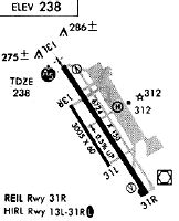
Runways
Runway Summary
| Runways: | 13L/31R 13R/31L H1 |
| Longest Runway: | 13L/31R is 6724 ft (2049 m) long |
| Runways with an Instrument Approach: | 13L |
CIC Airport Runway Details
| Runway 13L/31R | 6724 ft x 150 ft (2049 m x 46 m) | |
| Runway Length Source: | 3RD PARTY SURVEY as of 11/10/2007 | |
| Surface: | Asphalt - Good condition - Saw-cut or plastic grooved | |
| Runway Pavement Class: | 20 /F/B/X/T | |
| Runway Edge Lights: | High Intensity | |
Runway Weight Bearing Capacity (in thousands of pounds) |
||
| Single Wheel Landing Gear: | 63.0 | |
| Dual Wheel Landing Gear: | 100.0 | |
| Dual Tandem Wheel Landing Gear: | 170.0 | |
Runway 13L |
Runway 31R |
|
Elevation: |
240.2 | 207.2 |
Latitude: |
39-48-12.1750N | 39-47-16.1780N |
Longitude: |
121-51-50.8290W | 121-51-04.4520W |
|
Runway True Alignment: |
147 | 327 |
ILS Type: |
ILS/DME | |
Glide Path Angle: |
3.0 degrees | 3.0 degrees |
Traffic Pattern: |
Right | Left |
Runway Markings Type: |
Precision Instrument | Precision Instrument |
Runway Markings Condition: |
Good | Good |
Visual Glide Slope Indicators: |
4-Light PAPI On Left Side Of Runway | 4-Box VASI On Left Side Of Runway |
Approach Light System: |
1,400 Foot Medium Intensity Approach Lighting System With Runway Alignment Indicator Lights | |
REIL: |
No | Yes |
Touchdown Lights: |
No | No |
Centerline Lights: |
No | No |
Threshold Crossing Height: |
52 | 54 |
Declared Distances |
||
Take Off Run Avbl. (TORA): |
6724 | 6724 |
Take Off Distance Avbl. (TODA): |
6724 | 6724 |
Actual Stop Dist. Avbl. (ASDA): |
6724 | 6724 |
Landing Dist. Avbl. (LDA): |
6724 | 6724 |
| Runway 13R/31L | 3000 ft x 60 ft (914 m x 18 m) | |
| Runway Length Source: | 3RD PARTY SURVEY as of 11/10/2007 | |
| Surface: | Asphalt - Good condition - No special surface treatment | |
| Runway Pavement Class: | 9 /F/C/Y/T | |
Runway Weight Bearing Capacity (in thousands of pounds) |
||
| Single Wheel Landing Gear: | 12.5 | |
Runway 13R |
Runway 31L |
|
Elevation: |
226.9 | 215.0 |
Latitude: |
39-47-54.1962N | 39-47-29.2063N |
Longitude: |
121-51-46.5686W | 121-51-25.8867W |
|
Runway True Alignment: |
147 | 327 |
Glide Path Angle: |
0.0 degrees | 0.0 degrees |
Traffic Pattern: |
Right | Left |
Runway Markings Type: |
Basic | Basic |
Runway Markings Condition: |
Fair | Fair |
REIL: |
No | No |
Touchdown Lights: |
No | No |
Centerline Lights: |
No | No |
Declared Distances |
||
Take Off Run Avbl. (TORA): |
3000 | 3000 |
Take Off Distance Avbl. (TODA): |
3000 | 3000 |
Actual Stop Dist. Avbl. (ASDA): |
3000 | 3000 |
Landing Dist. Avbl. (LDA): |
3000 | 3000 |
| Helipad H1 | 64 ft x 64 ft (20 m x 20 m) | |
| Surface: | Asphalt - Good condition - No special surface treatment | |
Runway Weight Bearing Capacity (in thousands of pounds) |
||
| Single Wheel Landing Gear: | 35.0 | |
Helipad H1 |
||
Glide Path Angle: |
0.0 degrees | 0.0 degrees |
Services
Airframe Repair: |
Major |
Powerplant Repair: |
Major |
Bottled Oxygen: |
High Pressure / Low Pressure |
Bulk Oxygen: |
None |
Fuel Available: |
100LL, Jet A |
Parking: |
Hangars and tiedowns available |
Maps & Diagrams
CIC Sectional
Flight Planning
at skyvector.com
at skyvector.com