Location
Latitude: |
43-34-22.9500N (43.573042) |
Longitude: |
071-25-04.2300W (-71.417842) |
Elevation: |
545.4 feet MSL (166 m MSL) |
Magnetic Variation: |
14.3 W (as of April 2024 from WMM2020 model) |
Time Zone: |
UTC -5.0 (Standard Time) UTC -4.0 (Daylight Savings Time) |
From City: |
03 N.M. NE of Laconia, New Hampshire |
Found On: |
New York Chart |
FAA Region: |
ANE |
Contacts
Manager: |
Publicly owned: |
| MARV EVERSON 65 AVIATION DR GILFORD, NH 03429 603-524-5003 |
LACONIA AIRPORT AUTHORITY 65 AVIATION DR GILFORD, NH 03429 603-524-5003 |
Operations
Airport Status: |
Operational |
Facility Use: |
Public |
Type: |
Airport |
Activation Date: |
10/1946 |
Control tower: |
No |
Attendance (Months/Days/Hours): |
Months/Days/Hours MAY-OCT/ALL/0700-1900 |
Boundary ARTCC: |
ZBW (Boston) |
Responsible ARTCC: |
ZBW (Boston) |
Lighting Schedule: |
SEE RMK |
Segmented Circle Indicator: |
Yes |
Traffic Pattern Altitude (MSL): |
1545 feet (471 m) |
NOTAMs Facility: |
LCI |
NOTAM-D Service: |
Yes |
International Airport of Entry: |
No |
Customs Landing Rights: |
No |
Military Landing Rights: |
Yes |
Civil/Military Joint Use: |
No |
Based Aircraft
| Single Engine: | 102 |
| Multi Engine: | 10 |
| Jet Engine: | 4 |
| GA Helicopters: | 5 |
| Ultralights: | 1 |
Annual Operations (as of 09/16/2019)
| Total Operations: | 44100 | |
| Air Taxi: | 400 | 0.9% |
| GA Local: | 40000 | 90.7% |
| GA Itinerant: | 3595 | 8.2% |
| Military Aircraft: | 105 | 0.2% |
Communications
| CTAF: | 123.000 |
| Unicom: | 123.000 |
| Clearance Del.: | 119.85 119.85 119.85 119.85 |
| Approach: | BOSTON |
| Departure: | BOSTON |
| AWOS-3PT: | 133.525 (603-524-5134) |
Fixed Based Operators (FBOs) & Fuel
(Click on a business for detail)
Please help us keep this information up to date. This is a FREE SERVICE just like everything else on Airport Guide! If you see that a business needs to be added, modified, or deleted please fill out our Update Form.
To add, modify, or delete a business click here.
Please help us keep this information up to date. This is a FREE SERVICE just like everything else on Airport Guide! If you see that a business needs to be added, modified, or deleted please fill out our Update Form.
Area Code: 603 |
| Business Name | Frequency | Phone | Fuel Grade |
|---|---|---|---|
| Emerson Aviation, Inc.
Update FBO info |
293-7980 | 100LL, Jet A | |
| Lake Aircraft
Update FBO info |
524-5868, 293-8200 | ||
| Sky Bright, Inc.
Update FBO info |
Unicom 122.85 | 528-6818, 800-639-6012 | 100LL, Jet A |
Flight Service Stations
| Primary | Alternate | |
| FSS on Field: | N | |
| FSS Name (ID): | Bangor(BGR) | |
| Frequency: | ||
| Toll Free Phone: | 1-800-WX-BRIEF |
Instrument Procedures / Charts
FAA Terminal Procedures valid from 0901Z 03/21/24 to 0901Z 04/18/24.
There are various types of charts available for an airport. They are listed in the Page Type column. Here is a legend for those types:
APD - Airport Diagram
DP - Departure Procedure Charts
HOT - Hot Spots
IAP - Instrument Approach Procedure Charts
MIN - Minimums
STAR - Standard Terminal Arrival Charts
| Page Type | Page Name | Volume | Action Since Last Cycle |
|---|---|---|---|
| IAP | ILS OR LOC RWY 08 | NE-1 | |
| IAP | RNAV (GPS) RWY 08 | NE-1 | |
| IAP | RNAV (GPS) RWY 26 | NE-1 | |
| MIN | ALTERNATE MINIMUMS | NE-1 | |
| MIN | TAKEOFF MINIMUMS | NE-1 |
Terminal Procedures are only available for airports in several countries with more being added all the time. If you are looking for a specific country's charts, please send an email to support(at)airportguide.com stating the country name. This will be used to prioritize the implementation.
Navigation Aids (Navaids) near LCI
| Dist (NM) | ID | Morse Code | Name | Type | Freq | True Hdg | Mag Hdg |
|---|---|---|---|---|---|---|---|
| 1.1 | LCI | . _ . . _ . _ . . . | Laconia | FAN MARKER | 249 | 263 | |
| 5.6 | LC | . _ . . _ . _ . | Blnap | NDB | 328 | 247 | 261 |
| 22.3 | CON | _ . _ . _ _ _ _ . | Concord | VOR-DME | 112.90 | 198 | 212 |
| 27.3 | CO | _ . _ . _ _ _ | Epsom | NDB | 216 | 183 | 197 |
| 33.3 | ESG | . . . . _ _ . | Rollins | NDB | 260 | 129 | 143 |
| 33.9 | LAH | . _ . . . _ . . . . | Hanover | NDB | 276 | 283 | 297 |
| 34.0 | SZO | . . . _ _ . . _ _ _ | Sebago | NDB | 227 | 53 | 67 |
| 35.2 | LEB | . _ . . . _ . . . | Lebanon | DME | 113.7 | 280 | 294 |
| 36.1 | ENE | . _ . . | Kennebunk | VOR-DME | 117.10 | 103 | 117 |
| 38.9 | PSM | . _ _ . . . . _ _ | Pease | DME | 116.5 | 138 | 152 |
| 42.3 | MHT | _ _ . . . . _ | Manchester | VOR-DME | 114.40 | 177 | 191 |
| 42.8 | MJ | _ _ . _ _ _ | Fitzy | NDB | 209 | 186 | 200 |
| 43.3 | CNH | _ . _ . _ . . . . . | Claremont | NDB | 233 | 253 | 267 |
| 45.6 | IVV | . . . . . _ . . . _ | White River | NDB | 379 | 269 | 283 |
| 45.7 | AS | . _ . . . | Chern | NDB | 359 | 190 | 204 |
| 48.0 | HIE | . . . . . . . | Witey | FAN MARKER | 352 | 366 | |
| 48.4 | PWM | . _ _ . . _ _ _ _ | Portland | VOT | 111.00 | 84 | 99 |
| 48.7 | GMA | _ _ . _ _ . _ | Mahn | NDB | 386 | 346 | 360 |
| 51.9 | LWM | . _ . . . _ _ _ _ | Lawrence | DME | 112.5 | 164 | 178 |
| 52.3 | LE | . _ . . . | Lewie | NDB | 240 | 63 | 78 |
Nearby Airports with Fuel
Notices to Airmen (NOTAMS)
Remarks
| A110-1 | WILDLIFE ON & INVOF ARPT. |
| A110-2 | TWY A CLSD TO ACFT WITH WINGSPANS GTR THAN 49 FT. |
| A110-4 | FOR CD CTC BOSTON APCH AT 603-594-5552. |
| A110-6 | CTN: LOCKE'S HILL 500 FT TRRN MKD WITH 2 RED BCNS, 1.2 NM E OF ARPT. |
| A110-7 | CTN: RISING TRRN 5000 FT S OF ARPT. |
| A110-8 | RWY 26 DSGND CALM WIND RWY. |
| A110-9 | VOLUNTARY NOISE ABATEMENT PROC: AVOID OVERFLYING VARNEY POINT 1 NM NE OF ARPT. SEE LACONIA ARPT WEBSITE FOR DTLS. |
| A43-26 | PAPI UNUSBL BYD 6 DEGS L OF CNTRLN. |
| A70-FUEL-A | FOR JET A AFT HRS CALL FBOS. |
| A70-FUEL-10 | 0LL 100LL AVBL 24 HRS WITH CREDIT CARD. |
| A81-APT | DUSK-DAWN. ACTVT MALSR RWY 08; REIL RWY 26; HIRL RWY 08/26; WINDSOCK LGTS - CTAF. |
Runways
Runway Summary
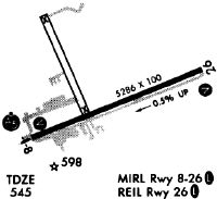
| Runways: | 08/26 |
| Longest Runway: | 08/26 is 5890 ft (1795 m) long |
| Runways with an Instrument Approach: | 08 |
LCI Airport Runway Details
| Runway 08/26 | 5890 ft x 100 ft (1795 m x 30 m) | |
| Runway Length Source: | FAA as of 11/09/2007 | |
| Surface: | Asphalt - Good condition - Saw-cut or plastic grooved | |
| Runway Pavement Class: | 35 /F/D/X/T | |
| Runway Edge Lights: | High Intensity | |
Runway Weight Bearing Capacity (in thousands of pounds) |
||
| Single Wheel Landing Gear: | 85.0 | |
| Dual Wheel Landing Gear: | 110.0 | |
| Dual Tandem Wheel Landing Gear: | 175.0 | |
Runway 08 |
Runway 26 |
|
Elevation: |
545.4 | 515.5 |
Latitude: |
43-34-11.8400N | 43-34-34.0600N |
Longitude: |
071-25-41.2000W | 071-24-27.2600W |
|
Runway True Alignment: |
068 | 248 |
ILS Type: |
ILS/DME | |
Glide Path Angle: |
3.0 degrees | 4.0 degrees |
Traffic Pattern: |
Left | Left |
Runway Markings Type: |
Precision Instrument | Nonprecision Instrument |
Runway Markings Condition: |
Good | Good |
Object at End: |
TREES | TREES |
Object Height: |
60 | 49 |
Distance from End: |
246 | 422 |
Object Centerline Offset: |
484 ft. right of centerline | 485 ft. right of centerline |
Visual Glide Slope Indicators: |
4-Light PAPI On Left Side Of Runway | 4-Light PAPI On Right Side Of Runway |
Approach Light System: |
1,400 Foot Medium Intensity Approach Lighting System With Runway Alignment Indicator Lights | |
REIL: |
Yes | |
Touchdown Lights: |
No | No |
Centerline Lights: |
No | No |
Threshold Crossing Height: |
44 | 55 |
Threshold Elevation: |
516.8 | |
Displaced Threshold: |
244 | |
Threshold Latitude: |
43-34-33.1360N | |
Threshold Longitude: |
071-24-30.3220W | |
Declared Distances |
||
Take Off Run Avbl. (TORA): |
5890 | 5890 |
Take Off Distance Avbl. (TODA): |
5890 | 5890 |
Actual Stop Dist. Avbl. (ASDA): |
5646 | 5530 |
Landing Dist. Avbl. (LDA): |
5646 | 5286 |
Services
Airframe Repair: |
None |
Powerplant Repair: |
None |
Bottled Oxygen: |
None |
Bulk Oxygen: |
None |
Fuel Available: |
100LL |
Landing Fees: |
No |
Parking: |
Tiedowns available |
Maps & Diagrams
LCI Sectional
Flight Planning
at skyvector.com
at skyvector.com