Location
Latitude: |
45-38-52.2000N (45.647833) |
Longitude: |
068-41-08.0000W (-68.685556) |
Elevation: |
408.1 feet MSL (124 m MSL) |
Magnetic Variation: |
15.7 W (as of April 2024 from WMM2020 model) |
Time Zone: |
UTC -5.0 (Standard Time) UTC -4.0 (Daylight Savings Time) |
From City: |
01 N.M. SE of Millinocket, Maine |
Found On: |
Halifax Chart |
FAA Region: |
ANE |
Contacts
Manager: |
Publicly owned: |
| TOWN OF MILLINOCKET MILLINOCKET MUNICIPAL ARPT.,, 16 MEDWAY RD. MILLINOCKET, ME 04462 207-723-6649 |
TOWN OF MILLINOCKET 197 PENOBSCOT AVE MILLINOCKET, ME 04462 207-723-6649 |
Operations
Airport Status: |
Operational |
Facility Use: |
Public |
Type: |
Airport |
Activation Date: |
04/1940 |
Control tower: |
No |
Attendance (Months/Days/Hours): |
Months/Days/Hours MAY-NOV/MON-FRI/0800-1600 |
Boundary ARTCC: |
ZBW (Boston) |
Responsible ARTCC: |
ZBW (Boston) |
Lighting Schedule: |
SEE RMK |
Segmented Circle Indicator: |
No |
Traffic Pattern Altitude (MSL): |
1408 feet (429 m) |
NOTAMs Facility: |
MLT |
NOTAM-D Service: |
Yes |
International Airport of Entry: |
No |
Customs Landing Rights: |
No |
Military Landing Rights: |
Yes |
Civil/Military Joint Use: |
No |
Based Aircraft
| Single Engine: | 16 |
| Multi Engine: | 1 |
| Gliders: | 1 |
Annual Operations (as of 08/24/2020)
| Total Operations: | 8400 | |
| Air Taxi: | 400 | 4.8% |
| GA Local: | 6000 | 71.4% |
| GA Itinerant: | 1000 | 11.9% |
| Military Aircraft: | 1000 | 11.9% |
Communications
| CTAF: | 122.800 |
| Unicom: | 122.800 |
| ASOS: | 135.225 (207-723-8396) |
- APCH/DEP SVC PRVDD BY BOSTON ARTCC ON FREQS 120.25/346.4 (BANGOR RCAG).
Fixed Based Operators (FBOs) & Fuel
(Click on a business for detail)
Please help us keep this information up to date. This is a FREE SERVICE just like everything else on Airport Guide! If you see that a business needs to be added, modified, or deleted please fill out our Update Form.
To add, modify, or delete a business click here.
Please help us keep this information up to date. This is a FREE SERVICE just like everything else on Airport Guide! If you see that a business needs to be added, modified, or deleted please fill out our Update Form.
Area Code: 207 |
| Business Name | Frequency | Phone | Fuel Grade |
|---|---|---|---|
| Plain Air Flying Service, Inc.
Update FBO info |
723-6649 | 100LL |
Flight Service Stations
| Primary | Alternate | |
| FSS on Field: | N | |
| FSS Name (ID): | Bangor(BGR) | |
| Frequency: | ||
| Toll Free Phone: | 1-800-WX-BRIEF |
Instrument Procedures / Charts
FAA Terminal Procedures valid from 0901Z 03/21/24 to 0901Z 04/18/24.
There are various types of charts available for an airport. They are listed in the Page Type column. Here is a legend for those types:
APD - Airport Diagram
DP - Departure Procedure Charts
HOT - Hot Spots
IAP - Instrument Approach Procedure Charts
MIN - Minimums
STAR - Standard Terminal Arrival Charts
| Page Type | Page Name | Volume | Action Since Last Cycle |
|---|---|---|---|
| IAP | RNAV (GPS) RWY 11 | NE-1 | |
| IAP | RNAV (GPS) RWY 29 | NE-1 | |
| IAP | VOR RWY 29 | NE-1 | |
| MIN | ALTERNATE MINIMUMS | NE-1 | |
| MIN | TAKEOFF MINIMUMS | NE-1 |
Terminal Procedures are only available for airports in several countries with more being added all the time. If you are looking for a specific country's charts, please send an email to support(at)airportguide.com stating the country name. This will be used to prioritize the implementation.
Navigation Aids (Navaids) near MLT
| Dist (NM) | ID | Morse Code | Name | Type | Freq | True Hdg | Mag Hdg |
|---|---|---|---|---|---|---|---|
| 5.7 | LNT | . _ . . _ . _ | Milnot | NDB | 344 | 89 | 105 |
| 8.0 | MLT | _ _ . _ . . _ | Millinocket | VOR-DME | 117.90 | 117 | 133 |
| 38.6 | OLD | _ _ _ . _ . . _ . . | Old Town | NDB | 272 | 176 | 192 |
| 42.6 | HUL | . . . . . . _ . _ . . | Houlton | DME | 116.1 | 56 | 72 |
| 45.5 | PNN | . _ _ . _ . _ . | Princeton | DME | 114.3 | 114 | 130 |
| 49.0 | BGR | _ . . . _ _ . . _ . | Bangor | VORTAC | 114.80 | 189 | 205 |
| 51.3 | BGR | _ . . . _ _ . . _ . | Bangor | VOT | 111.00 | 186 | 202 |
| 63.7 | BUP | _ . . . . . _ . _ _ . | Burnham | NDB | 348 | 206 | 221 |
| 64.1 | PQ | . _ _ . _ _ . _ | Excal | NDB | 278 | 25 | 41 |
| 68.5 | BH | _ . . . . . . . | Surry | NDB | 330 | 166 | 182 |
| 71.9 | PQI | . _ _ . _ _ . _ . . | Presque Isle | VOR-DME | 116.40 | 19 | 35 |
| 75.5 | BST | _ . . . . . . _ | Belfast | NDB | 278 | 190 | 206 |
| 83.3 | EPM | . . _ _ . _ _ | Eastport | NDB | 260 | 121 | 137 |
| 84.0 | RL | . _ . . _ . . | Bracy | NDB | 399 | 212 | 227 |
| 88.8 | FC | Fredericton | NDB | 326 | 78 | 94 | |
| 89.4 | AU | . _ . . _ | Dunns | NDB | 366 | 214 | 229 |
| 90.4 | IDC | Fredericton | DME | 111.30 | 81 | 97 | |
| 91.9 | VLV | . . . _ . _ . . . . . _ | Beauce | VOR-DME | 117.20 | 281 | 296 |
| 92.6 | AUG | . _ . . _ _ _ . | Augusta | VOR-DME | 114.95 | 211 | 226 |
| 96.0 | RM | . _ . _ _ | Noxks | NDB | 334 | 193 | 208 |
Nearby Airports with Fuel
Notices to Airmen (NOTAMS)
Remarks
| A110-10 | FOR CD IF UNA TO CTC ON FSS FREQ, CTC BOSTON ARTCC AT 603-879-6859 . |
| A110-2 | RWY 16/34 CLSD WINTER MONTHS EXCP SKI ACFT; SNOWBANK CROSSES INTXN RWY 16/34 AT RWY 11/29 & ALONG 1000 FT TWY PLOWED CNTR OF RWY 16/34 FM INTXN TO SOUTH TWY TO RAMP. |
| A110-7 | WILDLIFE ON AND INVOF ARPT. |
| A110-9 | +782 FT MSL COM/AIR QLTY MNT TWR LCTD APRXLY 5200 FT FM THR OF RWY 11 AT 247 DEGS. |
| A42-11 | FADED. |
| A42-16 | FADED. |
| A42-29 | FADED. |
| A42-34 | FADED. |
| A58-29 | SCRUB TREES 80 FT FM END OF RWY, 144 FT L. |
| A70-FUEL-10 | 0LL FUEL AVBL 24 HRS WITH CREDIT CARD. JET A AVBL AFT HRS 207-723-4375 OR 207-723-6649. |
| A75 | CALL 207-723-6649 FOR AVBL. |
| A76 | PAJA TO 10500 FT 0700 - SS DLY. |
| A81-APT | ACTVT REIL RWY 29; VASI RWY 29; MIRL RWY 11/29 - CTAF. |
| E111 | EXISTED PRIOR TO 1959. |
Runways
Runway Summary
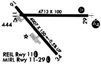
| Runways: | 11/29 16/34 |
| Longest Runway: | 11/29 is 4713 ft (1437 m) long |
| Runways with an Instrument Approach: | 29 |
MLT Seaplane Base Runway Details
| Runway 11/29 | 4713 ft x 99 ft (1437 m x 30 m) | |
| Runway Length Source: | 3RD PARTY SURVEY as of 03/12/2011 | |
| Surface: | Asphalt - Fair condition - No special surface treatment | |
| Runway Edge Lights: | Medium Intensity | |
Runway Weight Bearing Capacity (in thousands of pounds) |
||
| Single Wheel Landing Gear: | 30.0 | |
| Dual Wheel Landing Gear: | 44.0 | |
Runway 11 |
Runway 29 |
|
Elevation: |
400.9 | 395.1 |
Latitude: |
45-38-57.7364N | 45-38-57.4471N |
Longitude: |
068-41-34.0621W | 068-40-27.7249W |
|
Runway True Alignment: |
090 | 270 |
ILS Type: |
LOCALIZER | |
Glide Path Angle: |
0.0 degrees | 3.0 degrees |
Traffic Pattern: |
Left | Left |
Runway Markings Type: |
Nonprecision Instrument | Nonprecision Instrument |
Runway Markings Condition: |
Poor | Poor |
Object at End: |
BLDG | TREES |
Object Height: |
27 | 16 |
Object Marked/Lighted?: |
Lighted | |
Distance from End: |
465 | 451 |
Object Centerline Offset: |
240 ft. right of centerline | 35 ft. left of centerline |
Visual Glide Slope Indicators: |
4-Box VASI On Right Side Of Runway | |
REIL: |
No | Yes |
Touchdown Lights: |
No | No |
Centerline Lights: |
No | No |
Threshold Crossing Height: |
51 |
| Runway 16/34 | 4000 ft x 100 ft (1219 m x 30 m) | |
| Runway Length Source: | 3RD PARTY SURVEY as of 03/12/2011 | |
| Surface: | Asphalt - Fair condition - No special surface treatment | |
Runway Weight Bearing Capacity (in thousands of pounds) |
||
| Single Wheel Landing Gear: | 30.0 | |
| Dual Wheel Landing Gear: | 44.0 | |
Runway 16 |
Runway 34 |
|
Elevation: |
400.3 | 379.9 |
Latitude: |
45-39-00.7114N | 45-38-30.9378N |
Longitude: |
068-41-34.8173W | 068-40-57.8336W |
|
Runway True Alignment: |
139 | 319 |
Glide Path Angle: |
0.0 degrees | 0.0 degrees |
Traffic Pattern: |
Left | Left |
Runway Markings Type: |
Basic | Basic |
Runway Markings Condition: |
Poor | Poor |
Object at End: |
TREES | ROAD |
Object Height: |
62 | 15 |
Distance from End: |
1180 | 255 |
Object Centerline Offset: |
240 ft. right of centerline | 35 ft. left of centerline |
REIL: |
No | No |
Touchdown Lights: |
No | No |
Centerline Lights: |
No | No |
Services
Airframe Repair: |
None |
Powerplant Repair: |
None |
Fuel Available: |
MOGAS |
Landing Fees: |
No |
Parking: |
Tiedowns available |
Maps & Diagrams
MLT Sectional
Flight Planning
at skyvector.com
at skyvector.com