Location
Latitude: |
38-50-17.2000N (38.838111) |
Longitude: |
092-00-09.3000W (-92.002583) |
Elevation: |
886.6 feet MSL (270 m MSL) |
Magnetic Variation: |
0.6 W (as of April 2024 from WMM2020 model) |
Time Zone: |
UTC -6.0 (Standard Time) UTC -5.0 (Daylight Savings Time) |
From City: |
03 N.M. SW of Fulton, Missouri |
Found On: |
Kansas City Chart |
FAA Region: |
ACE |
Contacts
Manager: |
Publicly owned: |
| MATT EASLEY 4420 COUNTY RD 304 FULTON, MO 65251 573-220-0569 |
CITY OF FULTON 18 E. 4TH ST, BOX 130 FULTON, MO 65251 573-592-3111 |
Operations
Airport Status: |
Operational |
Facility Use: |
Public |
Type: |
Airport |
Activation Date: |
03/1942 |
Control tower: |
No |
Attendance (Months/Days/Hours): |
Months/Days/Hours UNATTENDED |
Boundary ARTCC: |
ZKC (Kansas City) |
Responsible ARTCC: |
ZKC (Kansas City) |
Lighting Schedule: |
SEE RMK |
Segmented Circle Indicator: |
Yes |
Traffic Pattern Altitude (MSL): |
1887 feet (575 m) |
NOTAMs Facility: |
COU |
NOTAM-D Service: |
Yes |
International Airport of Entry: |
No |
Customs Landing Rights: |
No |
Military Landing Rights: |
Yes |
Civil/Military Joint Use: |
No |
Based Aircraft
| Single Engine: | 47 |
| Multi Engine: | 2 |
| Jet Engine: | 1 |
Annual Operations (as of 12/31/2021)
| Total Operations: | 21250 | |
| Air Taxi: | 450 | 2.1% |
| GA Local: | 12050 | 56.7% |
| GA Itinerant: | 8250 | 38.8% |
| Military Aircraft: | 500 | 2.4% |
Communications
| CTAF: | 122.700 |
| Unicom: | 122.700 |
| Approach: | MIZZU 124.375 124.375 |
| Departure: | MIZZU 124.375 124.375 |
Fixed Based Operators (FBOs) & Fuel
(Click on a business for detail)
Please help us keep this information up to date. This is a FREE SERVICE just like everything else on Airport Guide! If you see that a business needs to be added, modified, or deleted please fill out our Update Form.
To add, modify, or delete a business click here.
Please help us keep this information up to date. This is a FREE SERVICE just like everything else on Airport Guide! If you see that a business needs to be added, modified, or deleted please fill out our Update Form.
Area Code: 573 |
| Business Name | Frequency | Phone | Fuel Grade |
|---|---|---|---|
| Advance Aviation
Update FBO info |
642-2838 | ||
| Tig-Air Aviation
Update FBO info |
642-6222 | 100LL, MOGAS |
Flight Service Stations
| Primary | Alternate | |
| FSS on Field: | N | |
| FSS Name (ID): | Columbia(COU) | |
| Frequency: | ||
| Toll Free Phone: | 1-800-WX-BRIEF |
Instrument Procedures / Charts
FAA Terminal Procedures valid from 0901Z 03/21/24 to 0901Z 04/18/24.
There are various types of charts available for an airport. They are listed in the Page Type column. Here is a legend for those types:
APD - Airport Diagram
DP - Departure Procedure Charts
HOT - Hot Spots
IAP - Instrument Approach Procedure Charts
MIN - Minimums
STAR - Standard Terminal Arrival Charts
| Page Type | Page Name | Volume | Action Since Last Cycle |
|---|---|---|---|
| IAP | RNAV (GPS) RWY 06 | NC-3 | |
| IAP | RNAV (GPS) RWY 18 | NC-3 | |
| IAP | RNAV (GPS) RWY 24 | NC-3 | |
| IAP | RNAV (GPS) RWY 36 | NC-3 | |
| IAP | VOR-A | NC-3 | |
| MIN | TAKEOFF MINIMUMS | NC-3 |
Terminal Procedures are only available for airports in several countries with more being added all the time. If you are looking for a specific country's charts, please send an email to support(at)airportguide.com stating the country name. This will be used to prioritize the implementation.
Navigation Aids (Navaids) near KFTT
| Dist (NM) | ID | Morse Code | Name | Type | Freq | True Hdg | Mag Hdg |
|---|---|---|---|---|---|---|---|
| 10.2 | COU | _ . _ . _ _ _ . . _ | Columbia | VOR-DME | 110.20 | 260 | 261 |
| 16.4 | JEF | . _ _ _ . . . _ . | Jefferson City | VOT | 112.00 | 208 | 209 |
| 17.5 | HLV | . . . . . _ . . . . . _ | Hallsville | VORTAC | 114.20 | 340 | 341 |
| 17.7 | JE | . _ _ _ . | Algoa | NDB | 397 | 190 | 191 |
| 43.3 | VIH | . . . _ . . . . . . | Vichy | VOR-DME | 117.70 | 161 | 162 |
| 49.0 | FTZ | . . _ . _ _ _ . . | Foristell | VORTAC | 110.80 | 99 | 100 |
| 51.5 | AIZ | . _ . . _ _ . . | Kaiser | NDB | 377 | 210 | 210 |
| 53.4 | UUV | . . _ . . _ . . . _ | Sullivan | NDB | 356 | 132 | 133 |
| 53.8 | MCM | _ _ _ . _ . _ _ | Macon | DME | 112.9 | 335 | 335 |
| 55.5 | DMO | _ . . _ _ _ _ _ | Sedalia | NDB | 281 | 262 | 262 |
| 55.5 | SHY | . . . . . . . _ . _ _ | Sunshine | VOR-DME | 108.40 | 210 | 210 |
| 57.0 | PUR | . _ _ . . . _ . _ . | Marshall | NDB | 371 | 282 | 282 |
| 59.0 | SU | . . . . . _ | Snoop | NDB | 326 | 101 | 102 |
| 64.1 | SUS | . . . . . _ . . . | Spirit Of St Louis | VOT | 112.20 | 99 | 100 |
| 66.1 | TBN | _ _ . . . _ . | Forney | VOR | 110.00 | 185 | 186 |
| 68.6 | BHN | _ . . . . . . . _ . | Buckhorn | NDB | 391 | 184 | 185 |
| 68.8 | FZ | . . _ . _ _ . . | Eaves | NDB | 227 | 97 | 98 |
| 69.3 | UIN | . . _ . . _ . | Quincy | TACAN | 113.60 | 28 | 29 |
| 71.1 | STL | . . . _ . _ . . | St Louis | VORTAC | 117.40 | 88 | 89 |
| 71.5 | LM | . _ . . _ _ | Oblio | NDB | 338 | 91 | 92 |
Nearby Airports with Fuel
Notices to Airmen (NOTAMS)
Remarks
| A110-2 | FOR CD CTC MIZZOU APCH AT 417-868-5620/5619. |
| A16 | AMGR CELL: 573-220-0569 AND AFTER HOURS SERVICE |
| A42-12 | 12/30 MARKED WTH LARGE YELLOW CONES. |
| A81-APT | ACTVT REIL RWY 06, 24, 18 & 36; PAPI RWY 06, 24, 18 & 36; MIRL RWY 06, 24, 18 & 36 - CTAF. |
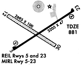
Runways
Runway Summary
| Runways: | 06/24 12/30 18/36 |
| Longest Runway: | 18/36 is 4001 ft (1220 m) long |
| Runways with an Instrument Approach: |
KFTT Airport Runway Details
| Runway 06/24 | 3203 ft x 60 ft (976 m x 18 m) | |
| Runway Length Source: | 3RD PARTY SURVEY as of 09/24/2010 | |
| Surface: | Concrete - Excellent condition - No special surface treatment | |
| Runway Pavement Class: | 5 /R/C/W/T | |
| Runway Edge Lights: | Medium Intensity | |
Runway Weight Bearing Capacity (in thousands of pounds) |
||
| Single Wheel Landing Gear: | 30.0 | |
Runway 06 |
Runway 24 |
|
Elevation: |
879.3 | 881.3 |
Latitude: |
38-50-15.5607N | 38-50-32.7533N |
Longitude: |
092-00-29.6711W | 091-59-55.6842W |
|
Runway True Alignment: |
057 | 237 |
Glide Path Angle: |
3.0 degrees | 4.0 degrees |
Traffic Pattern: |
Left | Left |
Runway Markings Type: |
Nonprecision Instrument | Nonprecision Instrument |
Runway Markings Condition: |
Good | Good |
Object at End: |
ROAD | |
Object Height: |
15 | |
Distance from End: |
315 | |
Object Centerline Offset: |
250 ft. left and right of centerline | |
Visual Glide Slope Indicators: |
2-Light PAPI On Left Side Of Runway | 2-Light PAPI On Left Side Of Runway |
REIL: |
Yes | Yes |
Threshold Crossing Height: |
46 | 61 |
| Runway 12/30 | 2488 ft x 100 ft (758 m x 30 m) | |
| Runway Length Source: | 3RD PARTY SURVEY as of 09/24/2010 | |
| Surface: | Concrete - Excellent condition - No special surface treatment | |
Runway 12 |
Runway 30 |
|
Elevation: |
885.4 | 875.9 |
Latitude: |
38-50-30.2838N | 38-50-16.6682N |
Longitude: |
092-00-32.4519W | 092-00-06.2664W |
|
Runway True Alignment: |
124 | 304 |
Glide Path Angle: |
0.0 degrees | 0.0 degrees |
Traffic Pattern: |
Left | Left |
Object Centerline Offset: |
250 ft. left and right of centerline |
| Runway 18/36 | 4001 ft x 75 ft (1220 m x 23 m) | |
| Runway Length Source: | 3RD PARTY SURVEY as of 09/24/2010 | |
| Surface: | Concrete - Excellent condition - No special surface treatment | |
| Runway Edge Lights: | Medium Intensity | |
Runway Weight Bearing Capacity (in thousands of pounds) |
||
| Single Wheel Landing Gear: | 12.5 | |
Runway 18 |
Runway 36 |
|
Elevation: |
877.4 | 877.2 |
Latitude: |
38-50-27.5797N | 38-49-48.0579N |
Longitude: |
091-59-59.5291W | 092-00-01.2238W |
|
Runway True Alignment: |
181 | 001 |
Glide Path Angle: |
3.0 degrees | 3.0 degrees |
Traffic Pattern: |
Left | Left |
Runway Markings Type: |
Nonprecision Instrument | Nonprecision Instrument |
Runway Markings Condition: |
Fair | Fair |
Object at End: |
TREES | |
Object Height: |
50 | |
Distance from End: |
1215 | |
Object Centerline Offset: |
250 ft. left and right of centerline | |
Visual Glide Slope Indicators: |
4-Light PAPI On Left Side Of Runway | 4-Light PAPI On Left Side Of Runway |
REIL: |
Yes | Yes |
Threshold Crossing Height: |
42 | 39 |
Services
Airframe Repair: |
Major |
Powerplant Repair: |
Minor |
Fuel Available: |
100LL, Jet A |
Landing Fees: |
No |
Parking: |
Hangars and tiedowns available |
Maps & Diagrams
KFTT Sectional
Flight Planning
at skyvector.com
at skyvector.com