Location
Latitude: |
34-38-13.9090N (34.637197) |
Longitude: |
086-46-30.1950W (-86.775054) |
Elevation: |
628.9 feet MSL (192 m MSL) |
Magnetic Variation: |
4 W (as of April 2024 from WMM2020 model) |
Time Zone: |
UTC -6.0 (Standard Time) UTC -5.0 (Daylight Savings Time) |
From City: |
09 N.M. SW of Huntsville, Alabama |
Found On: |
Atlanta Chart |
FAA Region: |
ASO |
Contacts
Manager: |
Publicly owned: |
| BUTCH ROBERTS 1000 GLENN HEARN BLVD,, BOX 20008 HUNTSVILLE, AL 35824 256-258-1958 |
HUNTSVILLE MADISON COUNTY 1000 GLENN HEARN BLVD, HUNTSVILLE, AL 35824 256-772-9395 |
Operations
Airport Status: |
Operational |
Facility Use: |
Public |
Type: |
Airport |
Activation Date: |
05/1964 |
Control tower: |
Yes |
Attendance (Months/Days/Hours): |
Months/Days/Hours ALL/ALL/ALL |
Boundary ARTCC: |
ZME (Memphis) |
Responsible ARTCC: |
ZME (Memphis) |
Lighting Schedule: |
SEE RMK |
Segmented Circle Indicator: |
Yes |
Traffic Pattern Altitude (MSL): |
1629 feet (497 m) |
NOTAMs Facility: |
HSV |
NOTAM-D Service: |
Yes |
International Airport of Entry: |
No |
Customs Landing Rights: |
Yes |
Military Landing Rights: |
Yes |
Civil/Military Joint Use: |
No |
Aircraft Rescue and Firefighting: |
Class I ARFF Index: C Air Carrier Service: Scheduled Certification Date: 05/1973 |
Based Aircraft
| Single Engine: | 63 |
| Multi Engine: | 15 |
| Jet Engine: | 6 |
| Ultralights: | 1 |
Annual Operations (as of 06/30/2023)
| Total Operations: | 63603 | |
| Commercial: | 14050 | 22.1% |
| Air Taxi: | 9674 | 15.2% |
| GA Local: | 3880 | 6.1% |
| GA Itinerant: | 16081 | 25.3% |
| Military Aircraft: | 19918 | 31.3% |
Communications
| CTAF: | 127.600 |
| Unicom: | 122.950 |
| Tower: | HUNTSVILLE 127.6 350.35 Hrs: 0600-0000 |
| Clearance Del.: | 120.35 |
| Ground: | 121.9 269.525 |
| Approach: | HUNTSVILLE 118.05 ;185-004 125.6 ;005-184 239.0 ;185-004 354.1 ;005-184 Hrs: 0600-0000 MEMPHIS ARTCC 118.75 Hrs: 0000-0600 |
| Departure: | HUNTSVILLE 118.05 ;185-004 125.6 ;005-184 239.0 ;185-004 354.1 ;005-184 Hrs: 0600-0000 MEMPHIS ARTCC 118.75 Hrs: 0000-0600 |
| ATIS: | 121.25 Hrs: 24 |
| ASOS: | 121.25 (256-772-8074) |
| CLASS C: | 118.05 ;185-004 |
| CLASS C: | 239.0 ;185-004 |
| EMERG: | 243.0 |
| EMERG: | 121.5 |
| CLASS C: | 354.1 ;005-184 |
| CLASS C: | 125.6 ;005-184 |
- APCH/DEP SVC PRVDD BY MEMPHIS ARTCC ON FREQS 120.8/307.0 (HUNTSVILLE RCAG) WHEN HUNTSVILLE APCH CTL CLSD.
Fixed Based Operators (FBOs) & Fuel
(Click on a business for detail)
Please help us keep this information up to date. This is a FREE SERVICE just like everything else on Airport Guide! If you see that a business needs to be added, modified, or deleted please fill out our Update Form.
To add, modify, or delete a business click here.
Please help us keep this information up to date. This is a FREE SERVICE just like everything else on Airport Guide! If you see that a business needs to be added, modified, or deleted please fill out our Update Form.
Area Code: 256 |
| Business Name | Frequency | Phone | Fuel Grade |
|---|---|---|---|
| Decatur Athens Aero Services
Update FBO info |
355-6159 | 100LL, Jet A | |
| Signature Flight Support
Website Update FBO info |
Unicom 122.95, Arinc 130.375 | +1 256 772 9341 | 100LL, Jet A |
Flight Service Stations
| Primary | Alternate | |
| FSS on Field: | N | |
| FSS Name (ID): | Anniston(ANB) | |
| Frequency: | ||
| Toll Free Phone: | 1-800-WX-BRIEF |
Instrument Procedures / Charts
FAA Terminal Procedures valid from 0901Z 03/21/24 to 0901Z 04/18/24.
There are various types of charts available for an airport. They are listed in the Page Type column. Here is a legend for those types:
APD - Airport Diagram
DP - Departure Procedure Charts
HOT - Hot Spots
IAP - Instrument Approach Procedure Charts
MIN - Minimums
STAR - Standard Terminal Arrival Charts
| Page Type | Page Name | Volume | Action Since Last Cycle |
|---|---|---|---|
| APD | AIRPORT DIAGRAM | SE-4 | Changed |
| DP | HUNTSVILLE FOUR | SE-4 | Changed |
| HOT | HOT SPOT | SE-4 | |
| IAP | ILS OR LOC RWY 18L | SE-4 | Changed |
| IAP | ILS OR LOC RWY 18R | SE-4 | Changed |
| IAP | ILS OR LOC RWY 36L | SE-4 | Changed |
| IAP | ILS OR LOC RWY 36R | SE-4 | Changed |
| IAP | ILS RWY 18R (CAT II) | SE-4 | Changed |
| IAP | RNAV (GPS) RWY 18L | SE-4 | |
| IAP | RNAV (GPS) RWY 18R | SE-4 | |
| IAP | RNAV (GPS) RWY 36L | SE-4 | |
| IAP | RNAV (GPS) RWY 36R | SE-4 | |
| MIN | ALTERNATE MINIMUMS | SE-4 | |
| MIN | RADAR MINIMUMS | SE-4 | |
| MIN | TAKEOFF MINIMUMS | SE-4 |
Terminal Procedures are only available for airports in several countries with more being added all the time. If you are looking for a specific country's charts, please send an email to support(at)airportguide.com stating the country name. This will be used to prioritize the implementation.
Navigation Aids (Navaids) near HSV
| Dist (NM) | ID | Morse Code | Name | Type | Freq | True Hdg | Mag Hdg |
|---|---|---|---|---|---|---|---|
| 0.2 | HSV | . . . . . . . . . . _ | Huntsville | VOT | 111.00 | 25 | 29 |
| 5.7 | HUA | . . . . . . _ . _ | Redstone | NDB | 287 | 49 | 53 |
| 8.1 | DCU | _ . . _ . _ . . . _ | Decatur | DME | 112.8 | 274 | 278 |
| 8.2 | CWH | _ . _ . . _ _ . . . . | Capshaw | NDB | 350 | 358 | 362 |
| 11.9 | RQZ | . _ . _ _ . _ _ _ . . | Rocket | VORTAC | 112.20 | 35 | 39 |
| 31.9 | TNY | _ _ . _ . _ _ | Kelso | NDB | 358 | 20 | 24 |
| 35.6 | MSL | _ _ . . . . _ . . | Muscle Shoals | DME | 116.25 | 276 | 280 |
| 35.7 | ARF | . _ . _ . . . _ . | Saratoga | NDB | 296 | 130 | 134 |
| 43.1 | LRT | . _ . . . _ . _ | Lawrenceburg | NDB | 269 | 326 | 330 |
| 47.6 | BGF | _ . . . _ _ . . . _ . | Boiling Fork | NDB | 263 | 46 | 50 |
| 51.6 | UXM | . . _ _ . . _ _ _ | Tullahoma Regional | VOR | 109.65 | 30 | 34 |
| 51.8 | LUG | . _ . . . . _ _ _ . | Verona | NDB | 251 | 358 | 362 |
| 52.4 | GAD | _ _ . . _ _ . . | Gadsden | VOR-DME | 112.30 | 138 | 142 |
| 53.0 | SYI | . . . _ . _ _ . . | Bomar | FAN MARKER | 16 | 20 | |
| 54.9 | FTP | . . _ . _ . _ _ . | Fort Payne | NDB | 426 | 96 | 100 |
| 56.0 | ULH | . . _ . _ . . . . . . | Burwi | NDB | 332 | 27 | 31 |
| 57.9 | SYI | . . . _ . _ _ . . | Shelbyville | VOR-DME | 113.55 | 16 | 20 |
| 58.4 | VUZ | . . . _ . . _ _ _ . . | Vulcan | VORTAC | 114.40 | 186 | 190 |
| 60.3 | PBC | . _ _ . _ . . . _ . _ . | Maury County | NDB | 365 | 345 | 349 |
| 63.9 | APT | . _ . _ _ . _ | Jasper | NDB | 382 | 66 | 70 |
Nearby Airports with Fuel
Notices to Airmen (NOTAMS)
Remarks
| A11 | AIRPORT AUTHORITY |
| A110-10 | LINE UP AND WAIT NA. |
| A110-13 | FOR CD WHEN TWR CLSD, IF UNA TO CTC ON FSS FREQ, CTC MEMPHIS ARTCC AT 901-368-8453/8449. |
| A110-14 | FLT NOTIFICATION SVC (ADCUS) AVBL. |
| A110-5 | INTXN OF TWY J AND SERVICE RD IS UNCONTROLLED. |
| A26 | CTC HSV ARFF ON CTAF OR PHONE 256-461-1115 FOR EMERG WHEN ATCT CLSD. |
| A57-36R | OBSTN CLNC SLOPE 50:1 AT DSPLCD THR. |
| A81-APT | ACTVT MALSR RWY 18L, 36L & 36R; HIRL RWY 18L/36R & 18R/36L - CTAF. RWY 18R ALSF ON STEP 2 WHEN ATCT CLSD. |
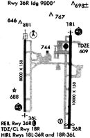
Runways
Runway Summary
| Runways: | 18L/36R 18R/36L |
| Longest Runway: | 18R/36L is 12600 ft (3840 m) long |
| Runways with an Instrument Approach: | 18L, 36R, 18R, 36L |
HSV Airport Runway Details
| Runway 18L/36R | 10001 ft x 150 ft (3048 m x 46 m) | |
| Runway Length Source: | 3RD PARTY SURVEY as of 03/09/2017 | |
| Surface: | Asphalt - Fair condition - Saw-cut or plastic grooved | |
| Runway Pavement Class: | 105/F/B/W/T | |
| Runway Edge Lights: | High Intensity | |
Runway Weight Bearing Capacity (in thousands of pounds) |
||
| Single Wheel Landing Gear: | 120.0 | |
| Dual Wheel Landing Gear: | 250.0 | |
| Dual Tandem Wheel Landing Gear: | 550.0 | |
Runway 18L |
Runway 36R |
|
Elevation: |
609.3 | 588.6 |
Latitude: |
34-39-11.1545N | 34-37-32.2495N |
Longitude: |
086-45-55.6731W | 086-45-57.6619W |
|
Runway True Alignment: |
181 | 001 |
ILS Type: |
ILS | ILS/DME |
Glide Path Angle: |
3.0 degrees | 3.0 degrees |
Traffic Pattern: |
Left | Right |
Runway Markings Type: |
Precision Instrument | Precision Instrument |
Runway Markings Condition: |
Good | Good |
Visual Glide Slope Indicators: |
4-Light PAPI On Right Side Of Runway | 4-Light PAPI On Right Side Of Runway |
Runway Visual Range (RVR): |
Touchdown, Rollout | Touchdown, Rollout |
Approach Light System: |
1,400 Foot Medium Intensity Approach Lighting System With Runway Alignment Indicator Lights | 1,400 Foot Medium Intensity Approach Lighting System With Runway Alignment Indicator Lights |
REIL: |
No | No |
Threshold Crossing Height: |
73 | 72 |
Threshold Elevation: |
589.0 | |
Displaced Threshold: |
200 | |
Threshold Latitude: |
34-37-34.2301N | |
Threshold Longitude: |
086-45-57.6222W | |
Declared Distances |
||
Take Off Run Avbl. (TORA): |
10001 | 10001 |
Take Off Distance Avbl. (TODA): |
10001 | 10001 |
Actual Stop Dist. Avbl. (ASDA): |
9801 | 10001 |
Landing Dist. Avbl. (LDA): |
9801 | 9801 |
| Runway 18R/36L | 12600 ft x 150 ft (3840 m x 46 m) | |
| Runway Length Source: | 3RD PARTY SURVEY as of 03/09/2017 | |
| Surface: | Asphalt - Fair condition - Saw-cut or plastic grooved | |
| Runway Pavement Class: | 120/F/A/X/T | |
| Runway Edge Lights: | High Intensity | |
Runway Weight Bearing Capacity (in thousands of pounds) |
||
| Single Wheel Landing Gear: | 120.0 | |
| Dual Wheel Landing Gear: | 250.0 | |
| Dual Tandem Wheel Landing Gear: | 550.0 | |
Runway 18R |
Runway 36L |
|
Elevation: |
628.4 | 611.2 |
Latitude: |
34-39-10.0278N | 34-37-05.4156N |
Longitude: |
086-46-55.5617W | 086-46-58.0470W |
|
Runway True Alignment: |
181 | 001 |
ILS Type: |
ILS | ILS/DME |
Glide Path Angle: |
0.0 degrees | 0.0 degrees |
Traffic Pattern: |
Right | Left |
Runway Markings Type: |
Precision Instrument | Precision Instrument |
Runway Markings Condition: |
Good | Good |
Runway Visual Range (RVR): |
Touchdown, Midfield, Rollout | Touchdown, Midfield, Rollout |
Approach Light System: |
Standard 2,400 Foot High Intensity Approach Lighting System With Sequenced Flashers, Cat. II or III Config. | 1,400 Foot Medium Intensity Approach Lighting System With Runway Alignment Indicator Lights |
REIL: |
No | No |
Touchdown Lights: |
Yes | Yes |
Centerline Lights: |
Yes | Yes |
Declared Distances |
||
Take Off Run Avbl. (TORA): |
12600 | 12600 |
Take Off Distance Avbl. (TODA): |
12600 | 12600 |
Actual Stop Dist. Avbl. (ASDA): |
12600 | 12600 |
Landing Dist. Avbl. (LDA): |
12600 | 12600 |
Services
Airframe Repair: |
Major |
Powerplant Repair: |
Major |
Bottled Oxygen: |
None |
Bulk Oxygen: |
None |
Fuel Available: |
100LL, Jet A+ |
Landing Fees: |
No |
Parking: |
Tiedowns available |
Maps & Diagrams
HSV Sectional
Flight Planning
at skyvector.com
at skyvector.com