Location
Latitude: |
40-31-39.6000N (40.527667) |
Longitude: |
086-03-35.1000W (-86.05975) |
Elevation: |
832.3 feet MSL (254 m MSL) |
Magnetic Variation: |
5.1 W (as of April 2024 from WMM2020 model) |
Time Zone: |
UTC -5.0 (Standard Time) UTC -4.0 (Daylight Savings Time) |
From City: |
04 N.M. NE of Kokomo, Indiana |
Found On: |
Chicago Chart |
FAA Region: |
AGL |
Contacts
Manager: |
Publicly owned: |
| SHAUN BAKER 3637 E COUNTY RD 400N KOKOMO, IN 46901 765-456-1742 |
KOKOMO BOAC 3637 E COUNTY RD 400N KOKOMO, IN 46901 765-456-7541 |
Operations
Airport Status: |
Operational |
Facility Use: |
Public |
Type: |
Airport |
Activation Date: |
06/1943 |
Control tower: |
No |
Attendance (Months/Days/Hours): |
Months/Days/Hours ALL/ALL/0800-1800 |
Boundary ARTCC: |
ZAU (Chicago) |
Responsible ARTCC: |
ZAU (Chicago) |
Lighting Schedule: |
SEE RMK |
Segmented Circle Indicator: |
No |
Traffic Pattern Altitude (MSL): |
1832 feet (558 m) |
NOTAMs Facility: |
OKK |
NOTAM-D Service: |
Yes |
International Airport of Entry: |
No |
Customs Landing Rights: |
No |
Military Landing Rights: |
Yes |
Civil/Military Joint Use: |
No |
Based Aircraft
| Single Engine: | 56 |
| Multi Engine: | 6 |
| GA Helicopters: | 1 |
Annual Operations (as of 12/31/2019)
| Total Operations: | 16990 | |
| Air Taxi: | 503 | 3.0% |
| GA Local: | 7414 | 43.6% |
| GA Itinerant: | 8409 | 49.5% |
| Military Aircraft: | 664 | 3.9% |
Communications
| CTAF: | 123.000 |
| Unicom: | 123.000 |
| Clearance Del.: | 120.0 120.0 120.0 |
| Approach: | GRISSOM CHICAGO ARTCC |
| Departure: | GRISSOM CHICAGO ARTCC |
| AWOS-3PT: | 128.675 (765-452-3014) |
- APCH/DEP SVC PRVDD BY CHICAGO ARTCC ON FREQS 121.05 (REMOTED FROM GRISSOM) WHEN GRISSOM APCH CTL CLSD.
Fixed Based Operators (FBOs) & Fuel
(Click on a business for detail)
Please help us keep this information up to date. This is a FREE SERVICE just like everything else on Airport Guide! If you see that a business needs to be added, modified, or deleted please fill out our Update Form.
To add, modify, or delete a business click here.
Please help us keep this information up to date. This is a FREE SERVICE just like everything else on Airport Guide! If you see that a business needs to be added, modified, or deleted please fill out our Update Form.
Area Code: 765 |
| Business Name | Frequency | Phone | Fuel Grade |
|---|---|---|---|
| Flying Eagle Aviation
Update FBO info |
Unicom 123.0 | 868-2084 | 100LL, Jet A |
Flight Service Stations
| Primary | Alternate | |
| FSS on Field: | N | |
| FSS Name (ID): | Terre Haute(HUF) | |
| Frequency: | ||
| Toll Free Phone: | 1-800-WX-BRIEF |
Instrument Procedures / Charts
FAA Terminal Procedures valid from 0901Z 03/21/24 to 0901Z 04/18/24.
There are various types of charts available for an airport. They are listed in the Page Type column. Here is a legend for those types:
APD - Airport Diagram
DP - Departure Procedure Charts
HOT - Hot Spots
IAP - Instrument Approach Procedure Charts
MIN - Minimums
STAR - Standard Terminal Arrival Charts
| Page Type | Page Name | Volume | Action Since Last Cycle |
|---|---|---|---|
| IAP | ILS OR LOC RWY 23 | EC-2 | |
| IAP | RNAV (GPS) RWY 05 | EC-2 | |
| IAP | RNAV (GPS) RWY 14 | EC-2 | |
| IAP | RNAV (GPS) RWY 23 | EC-2 | |
| IAP | RNAV (GPS) RWY 32 | EC-2 | |
| MIN | ALTERNATE MINIMUMS | EC-2 | |
| MIN | TAKEOFF MINIMUMS | EC-2 |
Terminal Procedures are only available for airports in several countries with more being added all the time. If you are looking for a specific country's charts, please send an email to support(at)airportguide.com stating the country name. This will be used to prioritize the implementation.
Navigation Aids (Navaids) near OKK
| Dist (NM) | ID | Morse Code | Name | Type | Freq | True Hdg | Mag Hdg |
|---|---|---|---|---|---|---|---|
| 0.1 | OKK | _ _ _ _ . _ _ . _ | Kokomo | TACAN | 113.50 | 84 | 89 |
| 8.2 | GUS | _ _ . . . _ . . . | Grissom | VORTAC | 108.45 | 329 | 334 |
| 17.5 | MZZ | _ _ _ _ . . _ _ . . | Marion | VOR-DME | 108.60 | 96 | 101 |
| 18.5 | IWH | . . . _ _ . . . . | Wabash | NDB | 329 | 40 | 45 |
| 27.7 | FKR | . . _ . _ . _ . _ . | Frankfort | NDB | 278 | 236 | 241 |
| 33.5 | HHG | . . . . . . . . _ _ . | Huntington | NDB | 417 | 53 | 58 |
| 35.1 | MIE | _ _ . . . | Muncie | VOR-DME | 114.40 | 119 | 124 |
| 35.4 | UMP | . . _ _ _ . _ _ . | Metropolitan | NDB | 338 | 179 | 184 |
| 37.2 | AI | . _ . . | Video | NDB | 394 | 137 | 142 |
| 39.7 | JN | . _ _ _ _ . | Balll | NDB | 365 | 121 | 126 |
| 42.0 | RWN | . _ . . _ _ _ . | Winamac/Dcmsnd | NDB | 335 | 324 | 329 |
| 43.9 | CPB | _ . _ . . _ _ . _ . . . | Culver | NDB | 391 | 340 | 345 |
| 45.0 | VHP | . . . _ . . . . . _ _ . | Brickyard | VORTAC | 116.30 | 198 | 203 |
| 45.7 | LA | . _ . . . _ | Earle | NDB | 401 | 262 | 267 |
| 46.1 | BVT | _ . . . . . . _ _ | Boiler | VORTAC | 115.10 | 272 | 277 |
| 47.8 | FWA | . . _ . . _ _ . _ | Fort Wayne Baer | VOT | 111.00 | 55 | 60 |
| 48.0 | FWA | . . _ . . _ _ . _ | Fort Wayne | VORTAC | 117.80 | 55 | 60 |
| 49.1 | IND | . . _ . _ . . | Indianapolis Intl | VOT | 109.60 | 193 | 198 |
| 50.1 | OLK | _ _ _ . _ . . _ . _ | Webster Lake | VOR | 110.40 | 30 | 35 |
| 51.1 | CFJ | _ . _ . . . _ . . _ _ _ | Crawfordsville | NDB | 388 | 230 | 235 |
Nearby Airports with Fuel
Notices to Airmen (NOTAMS)
Remarks
| A16 | 765-456-7542 EXT 5413. |
| A58-05 | CROPS 230 FT R & 350 FT L OF CL |
| A58-14 | CROPS 170 FT R OF CL |
| A58-23 | CROPS 140 FT R OF CL |
| A58-32 | CROPS 170 FT L & 175 R OF CL |
| A81-APT | ACTVT MALSR RWY 23; REIL RWY 05 & 14/32; PAPI RWY 05, 14, 32; HIRL RWY 05/23; MIRL RWY 14/32 - CTAF. |
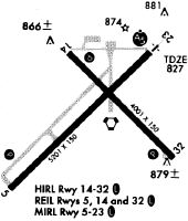
Runways
Runway Summary
| Runways: | 05/23 14/32 |
| Longest Runway: | 05/23 is 6001 ft (1829 m) long |
| Runways with an Instrument Approach: | 23 |
OKK Heliport Runway Details
| Runway 05/23 | 6001 ft x 150 ft (1829 m x 46 m) | |
| Runway Length Source: | 3RD PARTY SURVEY as of 11/20/2009 | |
| Surface: | Asphalt - Good condition - Saw-cut or plastic grooved | |
| Runway Edge Lights: | High Intensity | |
Runway Weight Bearing Capacity (in thousands of pounds) |
||
| Single Wheel Landing Gear: | 56.0 | |
| Dual Wheel Landing Gear: | 75.0 | |
| Dual Tandem Wheel Landing Gear: | 95.0 | |
Runway 05 |
Runway 23 |
|
Elevation: |
832.3 | 819.0 |
Latitude: |
40-31-15.8146N | 40-31-57.7911N |
Longitude: |
086-04-09.5418W | 086-03-14.6566W |
|
Runway True Alignment: |
045 | 225 |
ILS Type: |
ILS | |
Glide Path Angle: |
3.0 degrees | 0.0 degrees |
Traffic Pattern: |
Left | Left |
Runway Markings Type: |
Nonprecision Instrument | Precision Instrument |
Runway Markings Condition: |
Good | Good |
Object at End: |
TREE | |
Object Height: |
53 | |
Distance from End: |
1080 | |
Object Centerline Offset: |
625 ft. right of centerline | |
Visual Glide Slope Indicators: |
2-Light PAPI On Left Side Of Runway | |
Approach Light System: |
1,400 Foot Medium Intensity Approach Lighting System With Runway Alignment Indicator Lights | |
REIL: |
Yes | No |
Touchdown Lights: |
No | No |
Centerline Lights: |
No | No |
Threshold Crossing Height: |
35 |
| Runway 14/32 | 4002 ft x 150 ft (1220 m x 46 m) | |
| Runway Length Source: | 3RD PARTY SURVEY as of 11/20/2009 | |
| Surface: | Asphalt - Good condition - Saw-cut or plastic grooved | |
| Runway Edge Lights: | Medium Intensity | |
Runway Weight Bearing Capacity (in thousands of pounds) |
||
| Single Wheel Landing Gear: | 50.0 | |
| Dual Wheel Landing Gear: | 60.0 | |
| Dual Tandem Wheel Landing Gear: | 95.0 | |
Runway 14 |
Runway 32 |
|
Elevation: |
826.0 | 823.6 |
Latitude: |
40-31-57.7096N | 40-31-29.6854N |
Longitude: |
086-03-42.7688W | 086-03-06.2129W |
|
Runway True Alignment: |
135 | 315 |
Glide Path Angle: |
3.2 degrees | 3.2 degrees |
Traffic Pattern: |
Left | Left |
Runway Markings Type: |
Nonprecision Instrument | Nonprecision Instrument |
Runway Markings Condition: |
Good | Good |
Object Centerline Offset: |
625 ft. right of centerline | |
Visual Glide Slope Indicators: |
2-Light PAPI On Left Side Of Runway | 2-Light PAPI On Left Side Of Runway |
REIL: |
Yes | Yes |
Touchdown Lights: |
No | No |
Centerline Lights: |
No | No |
Threshold Crossing Height: |
33 | 33 |
Services
Airframe Repair: |
Minor |
Powerplant Repair: |
Minor |
Fuel Available: |
Jet A-1+ |
Landing Fees: |
No |
Parking: |
Tiedowns available |
Maps & Diagrams
OKK Sectional
Flight Planning
at skyvector.com
at skyvector.com