Location
Latitude: |
40-51-10.5000N (40.852917) |
Longitude: |
085-27-25.4000W (-85.457056) |
Elevation: |
805.7 feet MSL (246 m MSL) |
Magnetic Variation: |
5.6 W (as of April 2024 from WMM2020 model) |
Time Zone: |
UTC -5.0 (Standard Time) UTC -4.0 (Daylight Savings Time) |
From City: |
03 N.M. SE of Huntington, Indiana |
Found On: |
Chicago Chart |
FAA Region: |
AGL |
Contacts
Manager: |
Publicly owned: |
| SCOTT NICOLA 1365 WARREN RD HUNTINGTON, IN 46750 260-356-8515 |
HUNTINGTON BOAC 1365 WARREN RD HUNTINGTON, IN 46750 260-356-8515 |
Operations
Airport Status: |
Operational |
Facility Use: |
Public |
Type: |
Airport |
Activation Date: |
12/1942 |
Control tower: |
No |
Attendance (Months/Days/Hours): |
Months/Days/Hours ALL/SUN/1200-1700 |
Boundary ARTCC: |
ZAU (Chicago) |
Responsible ARTCC: |
ZAU (Chicago) |
Lighting Schedule: |
SEE RMK |
Segmented Circle Indicator: |
No |
Traffic Pattern Altitude (MSL): |
1806 feet (550 m) |
NOTAMs Facility: |
HUF |
NOTAM-D Service: |
Yes |
International Airport of Entry: |
No |
Customs Landing Rights: |
No |
Military Landing Rights: |
Yes |
Civil/Military Joint Use: |
No |
Based Aircraft
| Single Engine: | 62 |
| Multi Engine: | 3 |
Annual Operations (as of 12/31/2019)
| Total Operations: | 4477 | |
| Air Taxi: | 45 | 1.0% |
| GA Local: | 3000 | 67.0% |
| GA Itinerant: | 1432 | 32.0% |
Communications
| CTAF: | 122.800 |
| Unicom: | 122.800 |
| Approach: | FORT WAYNE 127.2 127.2 |
| Departure: | FORT WAYNE 127.2 127.2 |
| AWOS-3PT: | 126.575 (260-454-1927) |
Fixed Based Operators (FBOs) & Fuel
(Click on a business for detail)
Please help us keep this information up to date. This is a FREE SERVICE just like everything else on Airport Guide! If you see that a business needs to be added, modified, or deleted please fill out our Update Form.
To add, modify, or delete a business click here.
Please help us keep this information up to date. This is a FREE SERVICE just like everything else on Airport Guide! If you see that a business needs to be added, modified, or deleted please fill out our Update Form.
Area Code: 219 |
| Business Name | Frequency | Phone | Fuel Grade |
|---|---|---|---|
| Stars & Bars Aircraft
Update FBO info |
Unicom 122.8 | 356-6500, -8515 | 80, 100LL, Jet A |
Flight Service Stations
| Primary | Alternate | |
| FSS on Field: | N | |
| FSS Name (ID): | Terre Haute(HUF) | |
| Frequency: | ||
| Toll Free Phone: | 1-800-WX-BRIEF |
Instrument Procedures / Charts
FAA Terminal Procedures valid from 0901Z 03/21/24 to 0901Z 04/18/24.
There are various types of charts available for an airport. They are listed in the Page Type column. Here is a legend for those types:
APD - Airport Diagram
DP - Departure Procedure Charts
HOT - Hot Spots
IAP - Instrument Approach Procedure Charts
MIN - Minimums
STAR - Standard Terminal Arrival Charts
| Page Type | Page Name | Volume | Action Since Last Cycle |
|---|---|---|---|
| IAP | RNAV (GPS) RWY 10 | EC-2 | |
| IAP | RNAV (GPS) RWY 28 | EC-2 | |
| IAP | VOR-A | EC-2 | |
| MIN | ALTERNATE MINIMUMS | EC-2 | |
| MIN | TAKEOFF MINIMUMS | EC-2 |
Terminal Procedures are only available for airports in several countries with more being added all the time. If you are looking for a specific country's charts, please send an email to support(at)airportguide.com stating the country name. This will be used to prioritize the implementation.
Navigation Aids (Navaids) near KHHG
| Dist (NM) | ID | Morse Code | Name | Type | Freq | True Hdg | Mag Hdg |
|---|---|---|---|---|---|---|---|
| 0.3 | HHG | . . . . . . . . _ _ . | Huntington | NDB | 417 | 296 | 302 |
| 14.2 | FWA | . . _ . . _ _ . _ | Fort Wayne Baer | VOT | 111.00 | 57 | 63 |
| 14.4 | FWA | . . _ . . _ _ . _ | Fort Wayne | VORTAC | 117.80 | 58 | 64 |
| 16.4 | IWH | . . . _ _ . . . . | Wabash | NDB | 329 | 251 | 257 |
| 23.7 | OLK | _ _ _ . _ . . _ . _ | Webster Lake | VOR | 110.40 | 355 | 361 |
| 23.8 | MZZ | _ _ _ _ . . _ _ . . | Marion | VOR-DME | 108.60 | 205 | 211 |
| 33.6 | OKK | _ _ _ _ . _ _ . _ | Kokomo | TACAN | 113.50 | 234 | 239 |
| 34.0 | GUS | _ _ . . . _ . . . | Grissom | VORTAC | 108.45 | 248 | 253 |
| 35.8 | GW | _ _ . . _ _ | Shenk | NDB | 227 | 40 | 46 |
| 37.0 | MIE | _ _ . . . | Muncie | VOR-DME | 114.40 | 175 | 181 |
| 38.2 | VFU | . . . _ . . _ . . . _ | Stanley | NDB | 411 | 88 | 94 |
| 40.8 | JN | . _ _ _ _ . | Balll | NDB | 365 | 171 | 177 |
| 46.3 | CQA | _ . _ . _ _ . _ . _ | Lakefield | NDB | 205 | 118 | 124 |
| 47.1 | AI | . _ . . | Video | NDB | 394 | 182 | 188 |
| 47.3 | CPB | _ . _ . . _ _ . _ . . . | Culver | NDB | 391 | 297 | 302 |
| 47.9 | GSH | _ _ . . . . . . . . | Goshen | VORTAC | 113.70 | 327 | 332 |
| 50.1 | ANQ | . _ _ . _ _ . _ | Angola | NDB | 347 | 19 | 25 |
| 54.0 | RWN | . _ . . _ _ _ . | Winamac/Dcmsnd | NDB | 335 | 285 | 290 |
| 57.6 | IRS | . . . _ . . . . | Sturgis | NDB | 382 | 1 | 7 |
| 58.7 | UWL | . . _ . _ _ . _ . . | New Castle | NDB | 385 | 173 | 179 |
Nearby Airports with Fuel
Notices to Airmen (NOTAMS)
Remarks
| A110*G | THIS AIRPORT HAS BEEN SURVEYED BY THE NATIONAL GEODETIC SURVEY. |
| A110-2 | DEER ON & INVOF ARPT SPCLY MORNING & EVE. |
| A110-4 | FOR CD CTC CHICAGO ARTCC AT 630-906-8921. |
| A17 | UNATNDD HOLIDAYS. |
| A70-FUEL-10 | 0LL SELF SVC AVBL. |
| A81-APT | ACTVT REIL RWY 10 & 28; MIRL RWY 1028 - CTAF. MIRL RWY 10/28 PRESET LOW INTST; INCR INTST - CTAF. |
Runways
Runway Summary
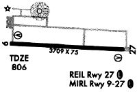
| Runways: | 10/28 |
| Longest Runway: | 10/28 is 5003 ft (1525 m) long |
| Runways with an Instrument Approach: |
KHHG Airport Runway Details
| Runway 10/28 | 5003 ft x 75 ft (1525 m x 23 m) | |
| Runway Length Source: | NGS as of 06/30/2010 | |
| Surface: | Asphalt - Good condition - Saw-cut or plastic grooved | |
| Runway Edge Lights: | Medium Intensity | |
Runway Weight Bearing Capacity (in thousands of pounds) |
||
| Single Wheel Landing Gear: | 38.0 | |
| Dual Wheel Landing Gear: | 50.0 | |
Runway 10 |
Runway 28 |
|
Elevation: |
804.8 | 804.2 |
Latitude: |
40-51-11.4582N | 40-51-09.5564N |
Longitude: |
085-27-57.9649W | 085-26-52.9119W |
|
Runway True Alignment: |
092 | 272 |
Glide Path Angle: |
3.0 degrees | 3.0 degrees |
Traffic Pattern: |
Left | Left |
Runway Markings Type: |
Nonprecision Instrument | Nonprecision Instrument |
Runway Markings Condition: |
Good | Good |
Object at End: |
TREES | TREES |
Object Height: |
33 | 55 |
Distance from End: |
300 | 1100 |
Object Centerline Offset: |
240 ft. right of centerline | 0 ft. left and right of centerline |
Visual Glide Slope Indicators: |
2-Light PAPI On Left Side Of Runway | 2-Light PAPI On Left Side Of Runway |
REIL: |
Yes | Yes |
Threshold Crossing Height: |
39 | 49 |
Services
Airframe Repair: |
Minor |
Powerplant Repair: |
Minor |
Bottled Oxygen: |
None |
Bulk Oxygen: |
None |
Fuel Available: |
100LL, Jet A |
Landing Fees: |
No |
Parking: |
Hangars and tiedowns available |
Maps & Diagrams
KHHG Sectional
Flight Planning
at skyvector.com
at skyvector.com