Location
Latitude: |
39-49-50.5827N (39.830717) |
Longitude: |
086-17-39.7887W (-86.294386) |
Elevation: |
822.5 feet MSL (251 m MSL) |
Magnetic Variation: |
4.9 W (as of April 2024 from WMM2020 model) |
Time Zone: |
UTC -5.0 (Standard Time) UTC -4.0 (Daylight Savings Time) |
From City: |
07 N.M. W of Indianapolis, Indiana |
Found On: |
St Louis Chart |
FAA Region: |
AGL |
Contacts
Manager: |
Publicly owned: |
| KEITH BERLEN 7800 COL. H. WEIR COOK MEMORIAL DR., SUITE 100 INDIANAPOLIS, IN 46241 (317) 487-5022 |
INDIANAPOLIS ARPT AUTH 7800 COL. H. WEIR COOK MEMORIAL DR., SUITE 100 INDIANAPOLIS, IN 46241 (317) 487-5022 |
Operations
Airport Status: |
Operational |
Facility Use: |
Public |
Type: |
Airport |
Activation Date: |
12/1966 |
Control tower: |
No |
Attendance (Months/Days/Hours): |
Months/Days/Hours ALL/ALL/0700-DUSK |
Boundary ARTCC: |
ZID (Indianapolis) |
Responsible ARTCC: |
ZID (Indianapolis) |
Lighting Schedule: |
SEE RMK |
Segmented Circle Indicator: |
Yes |
Traffic Pattern Altitude (MSL): |
1822 feet (555 m) |
NOTAMs Facility: |
EYE |
NOTAM-D Service: |
Yes |
International Airport of Entry: |
No |
Customs Landing Rights: |
No |
Military Landing Rights: |
Yes |
Civil/Military Joint Use: |
No |
Based Aircraft
| Single Engine: | 74 |
| Multi Engine: | 10 |
| Jet Engine: | 5 |
| Ultralights: | 1 |
Annual Operations (as of 12/31/2019)
| Total Operations: | 20874 | |
| Air Taxi: | 1253 | 6.0% |
| GA Local: | 12107 | 58.0% |
| GA Itinerant: | 7514 | 36.0% |
Communications
| CTAF: | 122.800 |
| Unicom: | 122.800 |
| Approach: | INDIANAPOLIS 119.05 119.05 119.05 119.05 119.05 119.05 119.05 |
| Departure: | INDIANAPOLIS 119.05 119.05 119.05 119.05 119.05 119.05 119.05 |
| ASOS: | 121.575 (317-329-1754) |
Fixed Based Operators (FBOs) & Fuel
(Click on a business for detail)
Please help us keep this information up to date. This is a FREE SERVICE just like everything else on Airport Guide! If you see that a business needs to be added, modified, or deleted please fill out our Update Form.
To add, modify, or delete a business click here.
Please help us keep this information up to date. This is a FREE SERVICE just like everything else on Airport Guide! If you see that a business needs to be added, modified, or deleted please fill out our Update Form.
Area Code: 317 |
| Business Name | Frequency | Phone | Fuel Grade |
|---|---|---|---|
| Eagle Creek Aviation Services, Inc.
Update FBO info |
Unicom 122.8 | 293-6935 | 100LL, Jet |
| Indiana Aircraft Sales, Inc.
Update FBO info |
293-4548 | 100LL, Jet |
Flight Service Stations
| Primary | Alternate | |
| FSS on Field: | N | |
| FSS Name (ID): | Terre Haute(HUF) | |
| Frequency: | ||
| Toll Free Phone: | 1-800-WX-BRIEF |
Instrument Procedures / Charts
FAA Terminal Procedures valid from 0901Z 03/21/24 to 0901Z 04/18/24.
There are various types of charts available for an airport. They are listed in the Page Type column. Here is a legend for those types:
APD - Airport Diagram
DP - Departure Procedure Charts
HOT - Hot Spots
IAP - Instrument Approach Procedure Charts
MIN - Minimums
STAR - Standard Terminal Arrival Charts
| Page Type | Page Name | Volume | Action Since Last Cycle |
|---|---|---|---|
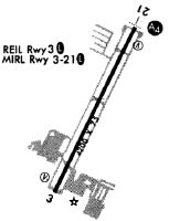
| APD | AIRPORT DIAGRAM | EC-2 | |
| DP | DAWNN ONE | EC-2 | |
| DP | DAWNN ONE[DELIMITER] CONT.1 | EC-2 | |
| DP | HOOSIER FIVE | EC-2 | |
| DP | MAREO FIVE | EC-2 | |
| DP | MEARZ SEVEN | EC-2 | |
| DP | MEARZ SEVEN[DELIMITER] CONT.1 | EC-2 | |
| DP | ROCKY ONE | EC-2 | |
| IAP | LOC RWY 21 | EC-2 | |
| IAP | RNAV (GPS) RWY 21 | EC-2 | |
| IAP | VOR-A | EC-2 | |
| MIN | ALTERNATE MINIMUMS | EC-2 | |
| MIN | TAKEOFF MINIMUMS | EC-2 | |
| STAR | CLANG SEVEN | EC-2 | |
| STAR | RACYR SIX | EC-2 |
Terminal Procedures are only available for airports in several countries with more being added all the time. If you are looking for a specific country's charts, please send an email to support(at)airportguide.com stating the country name. This will be used to prioritize the implementation.
Navigation Aids (Navaids) near KEYE
| Dist (NM) | ID | Morse Code | Name | Type | Freq | True Hdg | Mag Hdg |
|---|---|---|---|---|---|---|---|
| 3.5 | VHP | . . . _ . . . . . _ _ . | Brickyard | VORTAC | 116.30 | 254 | 259 |
| 5.9 | IND | . . _ . _ . . | Indianapolis Intl | VOT | 109.60 | 186 | 191 |
| 12.9 | UMP | . . _ _ _ . _ _ . | Metropolitan | NDB | 338 | 60 | 65 |
| 15.1 | HFY | . . . . . . _ . _ . _ _ | Greenwood | NDB | 398 | 141 | 146 |
| 24.6 | TVX | _ . . . _ _ . . _ | Greencastle | NDB | 521 | 253 | 258 |
| 24.7 | SHB | . . . . . . . _ . . . | Shelbyville | VOR-DME | 116.15 | 118 | 123 |
| 29.1 | FKR | . . _ . _ . _ . _ . | Frankfort | NDB | 278 | 335 | 340 |
| 30.0 | CFJ | _ . _ . . . _ . . _ _ _ | Crawfordsville | NDB | 388 | 287 | 292 |
| 37.6 | BA | _ . . . . _ | Clifs | NDB | 410 | 144 | 149 |
| 38.8 | AI | . _ . . | Video | NDB | 394 | 68 | 73 |
| 43.2 | OKK | _ _ _ _ . _ _ . _ | Kokomo | TACAN | 113.50 | 14 | 19 |
| 43.8 | OOM | _ _ _ _ _ _ _ _ | Hoosier | VORTAC | 110.20 | 199 | 204 |
| 45.0 | UWL | . . _ . _ _ . _ . . | New Castle | NDB | 385 | 85 | 90 |
| 48.0 | MIE | _ _ . . . | Muncie | VOR-DME | 114.40 | 59 | 64 |
| 48.6 | TTH | _ _ . . . . | Terre Haute | VORTAC | 115.30 | 245 | 250 |
| 48.7 | MZZ | _ _ _ _ . . _ _ . . | Marion | VOR-DME | 108.60 | 35 | 40 |
| 49.3 | GUS | _ _ . . . _ . . . | Grissom | VORTAC | 108.45 | 7 | 12 |
| 49.4 | JN | . _ _ _ _ . | Balll | NDB | 365 | 64 | 69 |
| 49.9 | LA | . _ . . . _ | Earle | NDB | 401 | 316 | 321 |
| 53.8 | SQ | . . . _ _ . _ | Pnthr | NDB | 227 | 93 | 98 |
Nearby Airports with Fuel
Notices to Airmen (NOTAMS)
Remarks
| A110*G | THIS AIRPORT HAS BEEN SURVEYED BY THE NATIONAL GEODETIC SURVEY. |
| A110-1 | OUTSIDE PHONES AVBL. |
| A110-2 | ACFT TKOF/LNDG FM RY 03 DURING CALM WIND/CROSSWIND CONDS; DURING ANY QUESTIONABLE PERIOD RY 03 SHALL BE PREFERRED RY - CALL AMGR 317-487-9594. |
| A110-3 | ACFT DEPARTING RY 3 MUST MAINTAIN RY HEADING UNTIL 1500 FT MSL BFR TURNING ON CRS. |
| A110-4 | FOR CD CTC INDIANAPOLIS APCH AT 317-227-5743. |
| A56-21 | CLOSEST INTCP POINT. |
| A57-03 | RWY 03 APCH RATIO 20:1 TO THLD |
| A70-FUEL-10 | 0LL 100LL HAS 24 HR SELF SERVICE |
| A81-APT | MIRL RY 03/21 PRESET ON LOW INTST; TO INCR INTST & ACTVT MALS RY 21 & REIL RY 03 - CTAF. |
Runways
Runway Summary
| Runways: | 03/21 |
| Longest Runway: | 03/21 is 4200 ft (1280 m) long |
| Runways with an Instrument Approach: | 21 |
KEYE Airport Runway Details
| Runway 03/21 | 4200 ft x 75 ft (1280 m x 23 m) | |
| Runway Length Source: | NGS as of 12/09/2006 | |
| Surface: | Asphalt - Good condition - No special surface treatment | |
| Runway Edge Lights: | Medium Intensity | |
Runway Weight Bearing Capacity (in thousands of pounds) |
||
| Single Wheel Landing Gear: | 12.5 | |
Runway 03 |
Runway 21 |
|
Elevation: |
817.1 | 822.5 |
Latitude: |
39-49-31.8568N | 39-50-09.3086N |
Longitude: |
086-17-51.3905W | 086-17-28.1868W |
|
Runway True Alignment: |
026 | 206 |
ILS Type: |
LOCALIZER | |
Glide Path Angle: |
3.0 degrees | 3.0 degrees |
Traffic Pattern: |
Left | Left |
Runway Markings Type: |
Nonprecision Instrument | Nonprecision Instrument |
Runway Markings Condition: |
Good | Good |
Object at End: |
TREES | ROAD |
Object Height: |
42 | 13 |
Distance from End: |
830 | 608 |
Object Centerline Offset: |
130 ft. left of centerline | 0 ft. left and right of centerline |
Visual Glide Slope Indicators: |
2-Light PAPI On Left Side Of Runway | 2-Light PAPI On Left Side Of Runway |
Approach Light System: |
1,400 Foot Medium Intensity Approach Lighting System | |
REIL: |
Yes | |
Touchdown Lights: |
No | No |
Centerline Lights: |
No | No |
Threshold Crossing Height: |
61 | 35 |
Services
Airframe Repair: |
Major |
Powerplant Repair: |
Major |
Bottled Oxygen: |
Low Pressure |
Bulk Oxygen: |
Low Pressure |
Fuel Available: |
100LL, Jet A |
Landing Fees: |
No |
Parking: |
Hangars and tiedowns available |
Maps & Diagrams
KEYE Sectional
Flight Planning
at skyvector.com
at skyvector.com