Location
Latitude: |
41-03-55.9711N (41.065548) |
Longitude: |
086-10-54.1304W (-86.181703) |
Elevation: |
789.5 feet MSL (241 m MSL) |
Magnetic Variation: |
5.1 W (as of April 2024 from WMM2020 model) |
Time Zone: |
UTC -5.0 (Standard Time) UTC -4.0 (Daylight Savings Time) |
From City: |
02 N.M. E of Rochester, Indiana |
Found On: |
Chicago Chart |
FAA Region: |
AGL |
Contacts
Manager: |
Publicly owned: |
| MATT WOODS 545 STATE RD 25N ROCHESTER, IN 46975 574-223-5384 |
FULTON COUNTY AIRPORT AUTHORITY 545 STATE RD 25N ROCHESTER, IN 46975 574-223-5384 |
Operations
Airport Status: |
Operational |
Facility Use: |
Public |
Type: |
Airport |
Activation Date: |
04/1940 |
Control tower: |
No |
Attendance (Months/Days/Hours): |
Months/Days/Hours ALL/ALL/0800-1700 |
Boundary ARTCC: |
ZAU (Chicago) |
Responsible ARTCC: |
ZAU (Chicago) |
Lighting Schedule: |
SEE RMK |
Segmented Circle Indicator: |
No |
Traffic Pattern Altitude (MSL): |
1790 feet (546 m) |
NOTAMs Facility: |
HUF |
NOTAM-D Service: |
Yes |
International Airport of Entry: |
No |
Customs Landing Rights: |
No |
Military Landing Rights: |
Yes |
Civil/Military Joint Use: |
No |
Based Aircraft
| Single Engine: | 9 |
| GA Helicopters: | 1 |
Annual Operations (as of 12/31/2019)
| Total Operations: | 13382 | |
| GA Local: | 6021 | 45.0% |
| GA Itinerant: | 7361 | 55.0% |
Communications
| CTAF: | 122.700 |
| Unicom: | 122.700 |
| Approach: | SOUTH BEND 132.05 132.05 CHICAGO ARTCC |
| Departure: | SOUTH BEND 132.05 132.05 CHICAGO ARTCC |
| AWOS-3: | 118.775 (574-223-3560) |
- APCH/DEP SVC PRVDD BY CHICAGO ARTCC ON FREQS 119.85/307.375 (FORT WAYNE RCAG); WHEN SOUTH BEND APCH CTL CLSD.
Fixed Based Operators (FBOs) & Fuel
(Click on a business for detail)
Please help us keep this information up to date. This is a FREE SERVICE just like everything else on Airport Guide! If you see that a business needs to be added, modified, or deleted please fill out our Update Form.
To add, modify, or delete a business click here.
Please help us keep this information up to date. This is a FREE SERVICE just like everything else on Airport Guide! If you see that a business needs to be added, modified, or deleted please fill out our Update Form.
Area Code: 219 |
| Business Name | Frequency | Phone | Fuel Grade |
|---|---|---|---|
| Fulton County Aviation
Update FBO info |
Unicom 122.7 | 223-5384 | 80, 100LL, Jet A |

|
 Avfuel |
100LL - 2.00 USD per gallon on 9/29/01 |
Pumps requiring line service |
Flight Service Stations
| Primary | Alternate | |
| FSS on Field: | N | |
| FSS Name (ID): | Terre Haute(HUF) | |
| Frequency: | ||
| Toll Free Phone: | 1-800-WX-BRIEF |
Instrument Procedures / Charts
FAA Terminal Procedures valid from 0901Z 03/21/24 to 0901Z 04/18/24.
There are various types of charts available for an airport. They are listed in the Page Type column. Here is a legend for those types:
APD - Airport Diagram
DP - Departure Procedure Charts
HOT - Hot Spots
IAP - Instrument Approach Procedure Charts
MIN - Minimums
STAR - Standard Terminal Arrival Charts
| Page Type | Page Name | Volume | Action Since Last Cycle |
|---|---|---|---|
| IAP | RNAV (GPS) RWY 11 | EC-2 | |
| IAP | RNAV (GPS) RWY 29 | EC-2 | |
| MIN | ALTERNATE MINIMUMS | EC-2 | |
| MIN | TAKEOFF MINIMUMS | EC-2 |
Terminal Procedures are only available for airports in several countries with more being added all the time. If you are looking for a specific country's charts, please send an email to support(at)airportguide.com stating the country name. This will be used to prioritize the implementation.
Navigation Aids (Navaids) near RCR
| Dist (NM) | ID | Morse Code | Name | Type | Freq | True Hdg | Mag Hdg |
|---|---|---|---|---|---|---|---|
| 12.9 | CPB | _ . _ . . _ _ . _ . . . | Culver | NDB | 391 | 314 | 319 |
| 19.2 | RWN | . _ . . _ _ _ . | Winamac/Dcmsnd | NDB | 335 | 275 | 280 |
| 25.1 | IWH | . . . _ _ . . . . | Wabash | NDB | 329 | 136 | 141 |
| 25.3 | GUS | _ _ . . . _ . . . | Grissom | VORTAC | 108.45 | 176 | 181 |
| 26.1 | OXI | _ _ _ _ . . _ . . | Knox | DME | 115.6 | 306 | 311 |
| 28.4 | GSH | _ _ . . . . . . . . | Goshen | VORTAC | 113.70 | 14 | 19 |
| 32.8 | OKK | _ _ _ _ . _ _ . _ | Kokomo | TACAN | 113.50 | 170 | 175 |
| 32.8 | OLK | _ _ _ . _ . . _ . _ | Webster Lake | VOR | 110.40 | 70 | 75 |
| 34.9 | HHG | . . . . . . . . _ _ . | Huntington | NDB | 417 | 110 | 115 |
| 37.2 | IUL | . . . . _ . _ . . | La Porte | NDB | 356 | 314 | 319 |
| 38.4 | SB | . . . _ . . . | Misha | NDB | 341 | 357 | 362 |
| 39.0 | VP | . . . _ . _ _ . | Sedly | NDB | 212 | 306 | 311 |
| 41.2 | MZZ | _ _ _ _ . . _ _ . . | Marion | VOR-DME | 108.60 | 146 | 151 |
| 42.6 | GIJ | _ _ . . . . _ _ _ | Gipper | VORTAC | 115.40 | 351 | 356 |
| 45.1 | FWA | . . _ . . _ _ . _ | Fort Wayne Baer | VOT | 111.00 | 96 | 101 |
| 45.3 | FWA | . . _ . . _ _ . _ | Fort Wayne | VORTAC | 117.80 | 96 | 101 |
| 50.6 | BVT | _ . . . . . . _ _ | Boiler | VORTAC | 115.10 | 233 | 238 |
| 50.8 | FKR | . . _ . _ . _ . _ . | Frankfort | NDB | 278 | 200 | 205 |
| 55.1 | LA | . _ . . . _ | Earle | NDB | 401 | 226 | 231 |
| 56.1 | IRS | . . . _ . . . . | Sturgis | NDB | 382 | 36 | 41 |
Nearby Airports with Fuel
Notices to Airmen (NOTAMS)
Remarks
| A110*G | THIS AIRPORT HAS BEEN SURVEYED BY THE NATIONAL GEODETIC SURVEY. |
| A110-1 | FOR CD CTC SOUTH BEND APCH AT 574-251-2609. WHEN SOUTH BEND APCH CLSD, FOR CD CTC CHICAGO ARTCC AT 630-906-8921. |
| A70-FUEL-10 | 0LL 100LL SELF SVC AVBL H24. |
| A81-APT | ACTVT REIL RWY 11 & 29; PAPI RWY 11 & 29; MIRL RWY 11/29 - CTAF. |
| A81-BCN | ACTVT BCN - CTAF |
Runways
Runway Summary
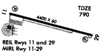
| Runways: | 11/29 |
| Longest Runway: | 11/29 is 5001 ft (1524 m) long |
| Runways with an Instrument Approach: |
RCR Airport Runway Details
| Runway 11/29 | 5001 ft x 75 ft (1524 m x 23 m) | |
| Runway Length Source: | NGS as of 11/09/2001 | |
| Surface: | Asphalt - Good condition - Saw-cut or plastic grooved | |
| Runway Edge Lights: | Medium Intensity | |
Runway Weight Bearing Capacity (in thousands of pounds) |
||
| Single Wheel Landing Gear: | 31.0 | |
| Dual Wheel Landing Gear: | 47.0 | |
Runway 11 |
Runway 29 |
|
Elevation: |
787.1 | 788.3 |
Latitude: |
41-04-02.4052N | 41-03-49.5370N |
Longitude: |
086-11-25.6449W | 086-10-22.6159W |
|
Runway True Alignment: |
105 | 285 |
Glide Path Angle: |
3.5 degrees | 3.4 degrees |
Traffic Pattern: |
Left | Left |
Runway Markings Type: |
Nonprecision Instrument | Nonprecision Instrument |
Runway Markings Condition: |
Fair | Fair |
Object at End: |
ROAD | TREES |
Object Height: |
15 | 85 |
Distance from End: |
580 | 3100 |
Object Centerline Offset: |
0 ft. left and right of centerline | 0 ft. left and right of centerline |
Visual Glide Slope Indicators: |
2-Light PAPI On Left Side Of Runway | 2-Light PAPI On Left Side Of Runway |
REIL: |
Yes | Yes |
Touchdown Lights: |
No | No |
Centerline Lights: |
No | No |
Threshold Crossing Height: |
50 | 30 |
Services
Airframe Repair: |
Major |
Powerplant Repair: |
Major |
Fuel Available: |
100LL, Jet A |
Landing Fees: |
No |
Parking: |
Tiedowns available |
Maps & Diagrams
RCR Sectional
Flight Planning
at skyvector.com
at skyvector.com