Location
Latitude: |
40-42-40.5520N (40.711264) |
Longitude: |
086-22-21.7370W (-86.372705) |
Elevation: |
738.4 feet MSL (225 m MSL) |
Magnetic Variation: |
4.9 W (as of April 2024 from WMM2020 model) |
Time Zone: |
UTC -5.0 (Standard Time) UTC -4.0 (Daylight Savings Time) |
From City: |
02 N.M. S of Logansport, Indiana |
Found On: |
Chicago Chart |
FAA Region: |
AGL |
Contacts
Manager: |
Publicly owned: |
| CHAD WEISEND 3735 S. AIRPORT RD LOGANSPORT, IN 46947 (574) 753-4300 |
LOGANSPORT CASS ARPT AUTHORITY 3735 S. AIRPORT RD LOGANSPORT, IN 46947 574-753-4300 |
Operations
Airport Status: |
Operational |
Facility Use: |
Public |
Type: |
Airport |
Activation Date: |
11/1959 |
Control tower: |
No |
Attendance (Months/Days/Hours): |
Months/Days/Hours ALL/ALL/0800-1800 |
Boundary ARTCC: |
ZAU (Chicago) |
Responsible ARTCC: |
ZAU (Chicago) |
Lighting Schedule: |
SEE RMK |
Segmented Circle Indicator: |
Yes |
Traffic Pattern Altitude (MSL): |
1738 feet (530 m) |
NOTAMs Facility: |
HUF |
NOTAM-D Service: |
Yes |
International Airport of Entry: |
No |
Customs Landing Rights: |
No |
Military Landing Rights: |
Yes |
Civil/Military Joint Use: |
No |
Based Aircraft
| Single Engine: | 15 |
| Multi Engine: | 2 |
| Jet Engine: | 1 |
Annual Operations (as of 12/31/2019)
| Total Operations: | 7816 | |
| Air Taxi: | 159 | 2.0% |
| GA Local: | 3439 | 44.0% |
| GA Itinerant: | 3905 | 50.0% |
| Military Aircraft: | 313 | 4.0% |
Communications
| CTAF: | 122.800 |
| Unicom: | 122.800 |
| Approach: | GRISSOM 121.05 121.05 CHICAGO ARTCC |
| Departure: | GRISSOM 121.05 121.05 CHICAGO ARTCC |
| AWOS-3P: | 118.5 (574-737-7310) |
- APCH/DEP SVC PRVDD BY CHICAGO ARTCC ON FREQS 121.05 (REMOTED FROM GRISSOM) WHEN GRISSOM APCH CTL CLSD.
Fixed Based Operators (FBOs) & Fuel
(Click on a business for detail)
Please help us keep this information up to date. This is a FREE SERVICE just like everything else on Airport Guide! If you see that a business needs to be added, modified, or deleted please fill out our Update Form.
To add, modify, or delete a business click here.
Please help us keep this information up to date. This is a FREE SERVICE just like everything else on Airport Guide! If you see that a business needs to be added, modified, or deleted please fill out our Update Form.
Area Code: 219 |
| Business Name | Frequency | Phone | Fuel Grade |
|---|---|---|---|
| Logansport Flying Service, Inc.
Update FBO info |
Unicom 122.8 | 753-4300 | 100LL, Jet A |
Flight Service Stations
| Primary | Alternate | |
| FSS on Field: | N | |
| FSS Name (ID): | Terre Haute(HUF) | |
| Frequency: | ||
| Toll Free Phone: | 1-800-WX-BRIEF |
Instrument Procedures / Charts
FAA Terminal Procedures valid from 0901Z 03/21/24 to 0901Z 04/18/24.
There are various types of charts available for an airport. They are listed in the Page Type column. Here is a legend for those types:
APD - Airport Diagram
DP - Departure Procedure Charts
HOT - Hot Spots
IAP - Instrument Approach Procedure Charts
MIN - Minimums
STAR - Standard Terminal Arrival Charts
| Page Type | Page Name | Volume | Action Since Last Cycle |
|---|---|---|---|
| IAP | RNAV (GPS) RWY 09 | EC-2 | |
| IAP | RNAV (GPS) RWY 27 | EC-2 | |
| MIN | TAKEOFF MINIMUMS | EC-2 |
Terminal Procedures are only available for airports in several countries with more being added all the time. If you are looking for a specific country's charts, please send an email to support(at)airportguide.com stating the country name. This will be used to prioritize the implementation.
Navigation Aids (Navaids) near KGGP
| Dist (NM) | ID | Morse Code | Name | Type | Freq | True Hdg | Mag Hdg |
|---|---|---|---|---|---|---|---|
| 10.8 | GUS | _ _ . . . _ . . . | Grissom | VORTAC | 108.45 | 111 | 116 |
| 18.1 | OKK | _ _ _ _ . _ _ . _ | Kokomo | TACAN | 113.50 | 127 | 132 |
| 25.3 | RWN | . _ . . _ _ _ . | Winamac/Dcmsnd | NDB | 335 | 335 | 340 |
| 26.3 | IWH | . . . _ _ . . . . | Wabash | NDB | 329 | 82 | 87 |
| 27.8 | FKR | . . _ . _ . _ . _ . | Frankfort | NDB | 278 | 198 | 203 |
| 30.3 | CPB | _ . _ . . _ _ . _ . . . | Culver | NDB | 391 | 358 | 363 |
| 33.1 | BVT | _ . . . . . . _ _ | Boiler | VORTAC | 115.10 | 253 | 258 |
| 34.2 | MZZ | _ _ _ _ . . _ _ . . | Marion | VOR-DME | 108.60 | 112 | 117 |
| 35.4 | LA | . _ . . . _ | Earle | NDB | 401 | 241 | 246 |
| 38.7 | OXI | _ _ _ _ . . _ . . | Knox | DME | 115.6 | 341 | 346 |
| 42.2 | HHG | . . . . . . . . _ _ . | Huntington | NDB | 417 | 77 | 82 |
| 48.7 | UMP | . . _ _ _ . _ _ . | Metropolitan | NDB | 338 | 162 | 167 |
| 49.9 | VP | . . . _ . _ _ . | Sedly | NDB | 212 | 332 | 337 |
| 50.4 | CFJ | _ . _ . . . _ . . _ _ _ | Crawfordsville | NDB | 388 | 209 | 214 |
| 50.6 | IUL | . . . . _ . _ . . | La Porte | NDB | 356 | 339 | 344 |
| 51.0 | OLK | _ _ _ . _ . . _ . _ | Webster Lake | VOR | 110.40 | 50 | 55 |
| 51.3 | GSH | _ _ . . . . . . . . | Goshen | VORTAC | 113.70 | 17 | 22 |
| 53.0 | MIE | _ _ . . . | Muncie | VOR-DME | 114.40 | 122 | 127 |
| 53.8 | VHP | . . . _ . . . . . _ _ . | Brickyard | VORTAC | 116.30 | 179 | 184 |
| 55.1 | AI | . _ . . | Video | NDB | 394 | 134 | 139 |
Nearby Airports with Fuel
Notices to Airmen (NOTAMS)
Remarks
| A110-3 | LANDFILL 1.5 NM NE OF ARPT. |
| A110-4 | FOR CD CTC CHICAGO ARTCC AT 630-906-8921. |
| A70-FUEL-10 | 0LL SELF SVC WITH CREDIT CARD. |
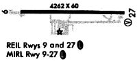
| A81-APT | ACTVT REIL RWY 09 & 27; PAPI RWY 09 & 27; MIRL RWY 09/27 - CTAF. MIRL RWY 09/27 PRESET LOW INTST; INCR INTST - CTAF. |
Runways
Runway Summary
| Runways: | 09/27 |
| Longest Runway: | 09/27 is 5001 ft (1524 m) long |
| Runways with an Instrument Approach: |
KGGP Airport Runway Details
| Runway 09/27 | 5001 ft x 75 ft (1524 m x 23 m) | |
| Runway Length Source: | 3RD PARTY SURVEY as of 05/28/2018 | |
| Surface: | Asphalt - Good condition - Saw-cut or plastic grooved | |
| Runway Edge Lights: | Medium Intensity | |
Runway Weight Bearing Capacity (in thousands of pounds) |
||
| Single Wheel Landing Gear: | 20.0 | |
Runway 09 |
Runway 27 |
|
Elevation: |
735.9 | 738.1 |
Latitude: |
40-42-40.2847N | 40-42-40.8167N |
Longitude: |
086-22-54.2053W | 086-21-49.2684W |
|
Runway True Alignment: |
089 | 269 |
Glide Path Angle: |
3.0 degrees | 3.0 degrees |
Traffic Pattern: |
Left | Left |
Runway Markings Type: |
Nonprecision Instrument | Nonprecision Instrument |
Runway Markings Condition: |
Good | Good |
Visual Glide Slope Indicators: |
2-Light PAPI On Left Side Of Runway | 2-Light PAPI On Left Side Of Runway |
REIL: |
Yes | Yes |
Touchdown Lights: |
No | No |
Centerline Lights: |
No | No |
Threshold Crossing Height: |
24 | 25 |
Declared Distances |
||
Take Off Run Avbl. (TORA): |
5001 | 5001 |
Take Off Distance Avbl. (TODA): |
5001 | 5001 |
Actual Stop Dist. Avbl. (ASDA): |
5001 | 5001 |
Landing Dist. Avbl. (LDA): |
5001 | 5001 |
Services
Airframe Repair: |
Minor |
Powerplant Repair: |
Minor |
Bottled Oxygen: |
None |
Bulk Oxygen: |
None |
Fuel Available: |
100LL |
Landing Fees: |
No |
Parking: |
Hangars and tiedowns available |
Maps & Diagrams
KGGP Sectional
Flight Planning
at skyvector.com
at skyvector.com