Location
Latitude: |
40-29-23.7000N (40.489917) |
Longitude: |
085-40-47.2000W (-85.679778) |
Elevation: |
858.7 feet MSL (262 m MSL) |
Magnetic Variation: |
5.4 W (as of April 2024 from WMM2020 model) |
Time Zone: |
UTC -5.0 (Standard Time) UTC -4.0 (Daylight Savings Time) |
From City: |
03 N.M. SW of Marion, Indiana |
Found On: |
Chicago Chart |
FAA Region: |
AGL |
Contacts
Manager: |
Publicly owned: |
| ANDY DARLINGTON 5904 S WESTERN AVE MARION, IN 46953 765-674-7777 |
CITY OF MARION BOAC 5904 S WESTERN AVE MARION, IN 46953 765-674-7777 |
Operations
Airport Status: |
Operational |
Facility Use: |
Public |
Type: |
Airport |
Activation Date: |
02/1938 |
Control tower: |
No |
Attendance (Months/Days/Hours): |
Months/Days/Hours ALL/MON-FRI/0700-1800 |
Boundary ARTCC: |
ZAU (Chicago) |
Responsible ARTCC: |
ZAU (Chicago) |
Lighting Schedule: |
SEE RMK |
Segmented Circle Indicator: |
Yes |
Traffic Pattern Altitude (MSL): |
1859 feet (567 m) |
NOTAMs Facility: |
HUF |
NOTAM-D Service: |
Yes |
International Airport of Entry: |
No |
Customs Landing Rights: |
No |
Military Landing Rights: |
Yes |
Civil/Military Joint Use: |
No |
Based Aircraft
| Single Engine: | 46 |
| Multi Engine: | 3 |
| Jet Engine: | 2 |
| GA Helicopters: | 3 |
Annual Operations (as of 12/31/2019)
| Total Operations: | 10873 | |
| Air Taxi: | 761 | 7.0% |
| GA Local: | 6090 | 56.0% |
| GA Itinerant: | 3914 | 36.0% |
| Military Aircraft: | 108 | 1.0% |
Communications
| CTAF: | 122.700 |
| Unicom: | 122.700 |
| Clearance Del.: | 120.0 120.0 120.0 |
| Approach: | GRISSOM CHICAGO ARTCC |
| Departure: | GRISSOM CHICAGO ARTCC |
| AWOS-3: | 108.6 (765-674-1317) |
- APCH/DEP SVC PRVDD BY CHICAGO ARTCC ON FREQS 121.05 (REMOTED FROM GRISSOM) WHEN GRISSOM APCH CTL CLSD.
Fixed Based Operators (FBOs) & Fuel
(Click on a business for detail)
Please help us keep this information up to date. This is a FREE SERVICE just like everything else on Airport Guide! If you see that a business needs to be added, modified, or deleted please fill out our Update Form.
To add, modify, or delete a business click here.
Please help us keep this information up to date. This is a FREE SERVICE just like everything else on Airport Guide! If you see that a business needs to be added, modified, or deleted please fill out our Update Form.
Area Code: 765 |
| Business Name | Frequency | Phone | Fuel Grade |
|---|---|---|---|
| Air Marion, Inc.
Update FBO info |
Unicom 122.7 | 674-7777 | 100LL, Jet A |
Flight Service Stations
| Primary | Alternate | |
| FSS on Field: | N | |
| FSS Name (ID): | Terre Haute(HUF) | |
| Frequency: | ||
| Toll Free Phone: | 1-800-WX-BRIEF |
Instrument Procedures / Charts
FAA Terminal Procedures valid from 0901Z 03/21/24 to 0901Z 04/18/24.
There are various types of charts available for an airport. They are listed in the Page Type column. Here is a legend for those types:
APD - Airport Diagram
DP - Departure Procedure Charts
HOT - Hot Spots
IAP - Instrument Approach Procedure Charts
MIN - Minimums
STAR - Standard Terminal Arrival Charts
| Page Type | Page Name | Volume | Action Since Last Cycle |
|---|---|---|---|
| IAP | ILS OR LOC RWY 04 | EC-2 | |
| IAP | RNAV (GPS) RWY 04 | EC-2 | |
| IAP | RNAV (GPS) RWY 15 | EC-2 | |
| IAP | RNAV (GPS) RWY 22 | EC-2 | |
| IAP | RNAV (GPS) RWY 33 | EC-2 | |
| IAP | VOR RWY 15 | EC-2 | |
| MIN | TAKEOFF MINIMUMS | EC-2 |
Terminal Procedures are only available for airports in several countries with more being added all the time. If you are looking for a specific country's charts, please send an email to support(at)airportguide.com stating the country name. This will be used to prioritize the implementation.
Navigation Aids (Navaids) near MZZ
| Dist (NM) | ID | Morse Code | Name | Type | Freq | True Hdg | Mag Hdg |
|---|---|---|---|---|---|---|---|
| 0.2 | MZZ | _ _ _ _ . . _ _ . . | Marion | VOR-DME | 108.60 | 6 | 11 |
| 17.3 | IWH | . . . _ _ . . . . | Wabash | NDB | 329 | 341 | 346 |
| 17.4 | OKK | _ _ _ _ . _ _ . _ | Kokomo | TACAN | 113.50 | 277 | 282 |
| 20.0 | MIE | _ _ . . . | Muncie | VOR-DME | 114.40 | 139 | 145 |
| 23.4 | GUS | _ _ . . . _ . . . | Grissom | VORTAC | 108.45 | 293 | 298 |
| 24.0 | HHG | . . . . . . . . _ _ . | Huntington | NDB | 417 | 24 | 30 |
| 24.8 | JN | . _ _ _ _ . | Balll | NDB | 365 | 138 | 144 |
| 26.4 | AI | . _ . . | Video | NDB | 394 | 162 | 167 |
| 36.8 | FWA | . . _ . . _ _ . _ | Fort Wayne Baer | VOT | 111.00 | 37 | 43 |
| 36.9 | FWA | . . _ . . _ _ . _ | Fort Wayne | VORTAC | 117.80 | 37 | 43 |
| 37.2 | UMP | . . _ _ _ . _ _ . | Metropolitan | NDB | 338 | 207 | 212 |
| 40.2 | UWL | . . _ . _ _ . _ . . | New Castle | NDB | 385 | 155 | 161 |
| 42.5 | FKR | . . _ . _ . _ . _ . | Frankfort | NDB | 278 | 252 | 257 |
| 46.2 | OLK | _ _ _ . _ . . _ . _ | Webster Lake | VOR | 110.40 | 10 | 16 |
| 49.7 | SQ | . . . _ _ . _ | Pnthr | NDB | 227 | 149 | 155 |
| 50.9 | CQA | _ . _ . _ _ . _ . _ | Lakefield | NDB | 205 | 90 | 96 |
| 51.3 | VHP | . . . _ . . . . . _ _ . | Brickyard | VORTAC | 116.30 | 218 | 223 |
| 51.9 | SHB | . . . . . . . _ . . . | Shelbyville | VOR-DME | 116.15 | 187 | 192 |
| 53.4 | VFU | . . . _ . . _ . . . _ | Stanley | NDB | 411 | 64 | 70 |
| 53.8 | IND | . . _ . _ . . | Indianapolis Intl | VOT | 109.60 | 212 | 217 |
Nearby Airports with Fuel
Notices to Airmen (NOTAMS)
Remarks
| A110-2 | FOR CD CTC CHICAGO ARTCC AT 630-906-8921. |
| A17 | UNATNDD CHRISTMAS DAY. |
| A30A-33 | -12 FT DITCH 200 FT L OF CNTRLN; 8 - 10 FT GND 230 FT L OF CNTRLN PARL S HALF OF RWY. |
| A43-33 | PAPI UNUSBL BYD 9 DEGS LEFT OF CNTRLN. |
| A58-22 | CROPS 285 R & 315 L OF CNTRLN. |
| A70-FUEL-10 | 0LL SELF SVC AVBL. |
| A81-APT | ACTVT MALSR RWY 04; REIL RWY 15, 22 & 33 - CTAF. PAPI RWY 15 & 33 ON DURG DAY; ACTVT AT NIGHT- CTAF. HIRL RWY 04/22; MIRL RWY 15/33 PRESET LOW INTST; INCR INTST - CTAF. |
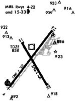
Runways
Runway Summary
| Runways: | 04/22 15/33 |
| Longest Runway: | 04/22 is 6011 ft (1832 m) long |
| Runways with an Instrument Approach: | 04 |
MZZ Airport Runway Details
| Runway 04/22 | 6011 ft x 100 ft (1832 m x 30 m) | |
| Runway Length Source: | 3RD PARTY SURVEY as of 06/20/2012 | |
| Surface: | Asphalt - Good condition - Saw-cut or plastic grooved | |
| Runway Pavement Class: | 28 /F/C/Y/T | |
| Runway Edge Lights: | High Intensity | |
Runway Weight Bearing Capacity (in thousands of pounds) |
||
| Single Wheel Landing Gear: | 60.0 | |
| Dual Wheel Landing Gear: | 90.0 | |
| Dual Tandem Wheel Landing Gear: | 70.0 | |
Runway 04 |
Runway 22 |
|
Elevation: |
858.1 | 850.0 |
Latitude: |
40-29-00.4672N | 40-29-47.5330N |
Longitude: |
085-41-12.9523W | 085-40-25.5037W |
|
Runway True Alignment: |
037 | 217 |
ILS Type: |
ILS | |
Glide Path Angle: |
0.0 degrees | 0.0 degrees |
Traffic Pattern: |
Left | Left |
Runway Markings Type: |
Precision Instrument | Nonprecision Instrument |
Runway Markings Condition: |
Good | Good |
Approach Light System: |
1,400 Foot Medium Intensity Approach Lighting System With Runway Alignment Indicator Lights | |
REIL: |
Yes | |
Touchdown Lights: |
No | No |
Centerline Lights: |
No | No |
| Runway 15/33 | 3456 ft x 100 ft (1053 m x 30 m) | |
| Runway Length Source: | 3RD PARTY SURVEY as of 06/20/2012 | |
| Surface: | Asphalt - Good condition - Saw-cut or plastic grooved | |
| Runway Edge Lights: | Medium Intensity | |
Runway Weight Bearing Capacity (in thousands of pounds) |
||
| Single Wheel Landing Gear: | 22.0 | |
| Dual Wheel Landing Gear: | 32.0 | |
Runway 15 |
Runway 33 |
|
Elevation: |
857.5 | 849.5 |
Latitude: |
40-29-38.1477N | 40-29-08.4648N |
Longitude: |
085-40-54.7935W | 085-40-32.6706W |
|
Runway True Alignment: |
150 | 330 |
Glide Path Angle: |
3.2 degrees | 4.0 degrees |
Traffic Pattern: |
Left | Left |
Runway Markings Type: |
Basic | Basic |
Runway Markings Condition: |
Good | Good |
Object at End: |
TREE | TREES |
Object Height: |
15 | 10 |
Distance from End: |
400 | 300 |
Visual Glide Slope Indicators: |
2-Light PAPI On Left Side Of Runway | 2-Light PAPI On Left Side Of Runway |
REIL: |
Yes | Yes |
Touchdown Lights: |
No | No |
Centerline Lights: |
No | No |
Threshold Crossing Height: |
40 | 38 |
Services
Airframe Repair: |
Minor |
Powerplant Repair: |
Minor |
Fuel Available: |
100LL |
Landing Fees: |
No |
Parking: |
Tiedowns available |
Maps & Diagrams
MZZ Sectional
Flight Planning
at skyvector.com
at skyvector.com