Location
Latitude: |
39-45-57.1550N (39.765876) |
Longitude: |
086-08-55.9500W (-86.148875) |
Elevation: |
732.0 feet MSL (223 m MSL) |
Magnetic Variation: |
5 W (as of April 2024 from WMM2020 model) |
Time Zone: |
UTC -5.0 (Standard Time) UTC -4.0 (Daylight Savings Time) |
From City: |
00 N.M. N of Indianapolis, Indiana |
Found On: |
St Louis Chart |
FAA Region: |
AGL |
Contacts
Manager: |
Publicly owned: |
| KEITH BERLEN 7800 COL. H. WEIR. COOK MEMORIAL DR INDIANAPOLIS, IN 46241 (317) 487-5022 |
INDIANAPOLIS ARPT AUTH 7800 COL. H. WEIR. COOK MEMORIAL DR INDIANAPOLIS, IN 46241 (317) 487-5022 |
Operations
Airport Status: |
Operational |
Facility Use: |
Public |
Type: |
Heliport |
Activation Date: |
12/1978 |
Control tower: |
No |
Attendance (Months/Days/Hours): |
Months/Days/Hours ALL/MON-FRI/0800-1630 |
Boundary ARTCC: |
ZID (Indianapolis) |
Responsible ARTCC: |
ZID (Indianapolis) |
Lighting Schedule: |
SEE RMK |
Segmented Circle Indicator: |
No |
Traffic Pattern Altitude (MSL): |
1732 feet (528 m) |
NOTAMs Facility: |
HUF |
NOTAM-D Service: |
Yes |
Customs Landing Rights: |
No |
Military Landing Rights: |
Yes |
Based Aircraft
| GA Helicopters: | 1 |
Annual Operations (as of 12/31/2019)
| Total Operations: | 1696 | |
| Air Taxi: | 17 | 1.0% |
| GA Itinerant: | 1662 | 98.0% |
| Military Aircraft: | 17 | 1.0% |
Communications
| CTAF: | 123.050 |
| Unicom: | 123.050 |
| Approach: | INDIANAPOLIS 125.275 125.275 |
| Departure: | INDIANAPOLIS 125.275 125.275 |
| AWOS-3: | 135.525 (317-955-3160) |
Fixed Based Operators (FBOs) & Fuel
(Click on a business for detail)
Please help us keep this information up to date. This is a FREE SERVICE just like everything else on Airport Guide! If you see that a business needs to be added, modified, or deleted please fill out our Update Form.
To add, modify, or delete a business click here.
Please help us keep this information up to date. This is a FREE SERVICE just like everything else on Airport Guide! If you see that a business needs to be added, modified, or deleted please fill out our Update Form.
Area Code: 317 |
| Business Name | Frequency | Phone | Fuel Grade |
|---|---|---|---|
| Indianapolis Heliport Corporation
Update FBO info |
Unicom 123.05 | 262-3000 | Jet A |
Flight Service Stations
| Primary | Alternate | |
| FSS on Field: | N | |
| FSS Name (ID): | Terre Haute(HUF) | |
| Frequency: | ||
| Toll Free Phone: | 1-800-WX-BRIEF |
Instrument Procedures / Charts
FAA Terminal Procedures valid from 0901Z 03/21/24 to 0901Z 04/18/24.
There are various types of charts available for an airport. They are listed in the Page Type column. Here is a legend for those types:
APD - Airport Diagram
DP - Departure Procedure Charts
HOT - Hot Spots
IAP - Instrument Approach Procedure Charts
MIN - Minimums
STAR - Standard Terminal Arrival Charts
| Page Type | Page Name | Volume | Action Since Last Cycle |
|---|---|---|---|
| IAP | COPTER RNAV (GPS) 291 | EC-2 | |
| IAP | COPTER VOR/DME 287 | EC-2 |
Terminal Procedures are only available for airports in several countries with more being added all the time. If you are looking for a specific country's charts, please send an email to support(at)airportguide.com stating the country name. This will be used to prioritize the implementation.
Navigation Aids (Navaids) near 8A4
| Dist (NM) | ID | Morse Code | Name | Type | Freq | True Hdg | Mag Hdg |
|---|---|---|---|---|---|---|---|
| 7.6 | IND | . . _ . _ . . | Indianapolis Intl | VOT | 109.60 | 254 | 259 |
| 8.4 | HFY | . . . . . . _ . _ . _ _ | Greenwood | NDB | 398 | 161 | 166 |
| 10.5 | VHP | . . . _ . . . . . _ _ . | Brickyard | VORTAC | 116.30 | 286 | 291 |
| 11.3 | UMP | . . _ _ _ . _ _ . | Metropolitan | NDB | 338 | 23 | 28 |
| 17.0 | SHB | . . . . . . . _ . . . | Shelbyville | VOR-DME | 116.15 | 118 | 123 |
| 30.5 | TVX | _ . . . _ _ . . _ | Greencastle | NDB | 521 | 264 | 269 |
| 30.7 | BA | _ . . . . _ | Clifs | NDB | 410 | 150 | 155 |
| 34.6 | AI | . _ . . | Video | NDB | 394 | 57 | 62 |
| 35.8 | FKR | . . _ . _ . _ . _ . | Frankfort | NDB | 278 | 327 | 332 |
| 37.6 | CFJ | _ . _ . . . _ . . _ _ _ | Crawfordsville | NDB | 388 | 290 | 295 |
| 38.9 | UWL | . . _ . _ _ . _ . . | New Castle | NDB | 385 | 79 | 84 |
| 43.1 | OOM | _ _ _ _ _ _ _ _ | Hoosier | VORTAC | 110.20 | 210 | 215 |
| 44.8 | MIE | _ _ . . . | Muncie | VOR-DME | 114.40 | 50 | 55 |
| 45.5 | JN | . _ _ _ _ . | Balll | NDB | 365 | 56 | 61 |
| 45.9 | OKK | _ _ _ _ . _ _ . _ | Kokomo | TACAN | 113.50 | 5 | 10 |
| 47.0 | SQ | . . . _ _ . _ | Pnthr | NDB | 227 | 88 | 93 |
| 48.3 | HLB | . . . . . _ . . _ . . . | Batesville | NDB | 254 | 121 | 126 |
| 48.7 | MZZ | _ _ _ _ . . _ _ . . | Marion | VOR-DME | 108.60 | 26 | 31 |
| 52.7 | GUS | _ _ . . . _ . . . | Grissom | VORTAC | 108.45 | 359 | 364 |
| 53.5 | TTH | _ _ . . . . | Terre Haute | VORTAC | 115.30 | 252 | 257 |
Nearby Airports with Fuel
Notices to Airmen (NOTAMS)
Remarks
| A110-1 | FAC & ARPT REGS PER INDIANAPOLIS ARPT AUTH. |
| A110-2 | COORD INGRESS/EGRESS WITH INDIANAPOLIS APCH - 125.275; ARR & DEP E OR W HDG; RMN S OF HELI; UTILIZE RR & INTERSTATE FOR INGRESS/EGRESS. |
| A110-4 | NOISE ABATEMENT PROC IN EFCT - AMGR. |
| A110-6 | FOR CD CTC INDIANAPOLIS APCH AT 317-227-5743. |
| A17 | INFO - 317-955-1271; AFT HR - 317-487-5089. |
| A43-H1 | PULSATING APCH SLOPE INDICATOR; ON E APCH. |
| A49-H1 | ODALS WB INGRESS |
| A52-H1 | BLDG AREA NE LGTD. |
| A70-FUEL-A1 | + SELF SERVE. |
| A71 | MINOR REPAIRS - 317-487-5089. |
| A81-APT | ACTVT ODALS; PLASI; HIGH INTST PAD LGTS - CTAF. |
Runways
Runway Summary
| Runways: | H1 |
| Longest Runway: | H1 is 60 ft (18 m) long |
| Runways with an Instrument Approach: |
8A4 Airport Runway Details
| Helipad H1 | 60 ft x 60 ft (18 m x 18 m) | |
| Surface: | Concrete - Good condition - No special surface treatment | |
Helipad H1 |
||
Elevation: |
732.0 | |
Latitude: |
39-45-57.1550N | |
Longitude: |
086-08-55.9500W | |
Glide Path Angle: |
0.0 degrees | 0.0 degrees |
Runway Markings Type: |
Basic | |
Runway Markings Condition: |
Good | |
Visual Glide Slope Indicators: |
Nonstandard VASI System | |
REIL: |
No |
Services
Airframe Repair: |
Major |
Powerplant Repair: |
Major |
Bottled Oxygen: |
Low Pressure |
Bulk Oxygen: |
Low Pressure |
Fuel Available: |
100LL, Jet A |
Landing Fees: |
No |
Parking: |
Hangars and tiedowns available |
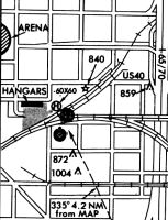
Maps & Diagrams
8A4 Sectional
Flight Planning
at skyvector.com
at skyvector.com