Location
Latitude: |
40-45-43.1000N (40.761972) |
Longitude: |
085-47-55.5000W (-85.79875) |
Elevation: |
795.6 feet MSL (242 m MSL) |
Magnetic Variation: |
5.4 W (as of April 2024 from WMM2020 model) |
Time Zone: |
UTC -5.0 (Standard Time) UTC -4.0 (Daylight Savings Time) |
From City: |
03 N.M. SE of Wabash, Indiana |
Found On: |
Chicago Chart |
FAA Region: |
AGL |
Contacts
Manager: |
Publicly owned: |
| JONATHAN DERBY 283 W. 400 S. WABASH, IN 46992 260-563-4705 |
WABASH BOAC 283 W. 400 S. WABASH, IN 46992 260-563-4705 |
Operations
Airport Status: |
Operational |
Facility Use: |
Public |
Type: |
Airport |
Activation Date: |
05/1958 |
Control tower: |
No |
Attendance (Months/Days/Hours): |
Months/Days/Hours NOV-APR/MON - SAT/0800-1700 |
Boundary ARTCC: |
ZAU (Chicago) |
Responsible ARTCC: |
ZAU (Chicago) |
Lighting Schedule: |
SEE RMK |
Segmented Circle Indicator: |
No |
Traffic Pattern Altitude (MSL): |
1796 feet (547 m) |
NOTAMs Facility: |
HUF |
NOTAM-D Service: |
Yes |
International Airport of Entry: |
No |
Customs Landing Rights: |
No |
Military Landing Rights: |
Yes |
Civil/Military Joint Use: |
No |
Based Aircraft
| Single Engine: | 9 |
| Jet Engine: | 2 |
| GA Helicopters: | 2 |
Annual Operations (as of 12/31/2019)
| Total Operations: | 4505 | |
| Air Taxi: | 90 | 2.0% |
| GA Local: | 3109 | 69.0% |
| GA Itinerant: | 1306 | 29.0% |
Communications
| CTAF: | 122.800 |
| Unicom: | 122.800 |
| Approach: | GRISSOM 121.05 121.05 CHICAGO ARTCC |
| Departure: | GRISSOM 121.05 121.05 CHICAGO ARTCC |
- APCH/DEP SVC PRVDD BY CHICAGO ARTCC ON FREQS 121.05 (REMOTED FROM GRISSOM) WHEN GRISSOM APCH CTL CLSD.
Fixed Based Operators (FBOs) & Fuel
(Click on a business for detail)
Please help us keep this information up to date. This is a FREE SERVICE just like everything else on Airport Guide! If you see that a business needs to be added, modified, or deleted please fill out our Update Form.
To add, modify, or delete a business click here.
Please help us keep this information up to date. This is a FREE SERVICE just like everything else on Airport Guide! If you see that a business needs to be added, modified, or deleted please fill out our Update Form.
Area Code: 219 |
| Business Name | Frequency | Phone | Fuel Grade |
|---|---|---|---|
| Wabash Municipal
Update FBO info |
Unicom 122.8 | 563-4705 | 100LL, Jet A |
Flight Service Stations
| Primary | Alternate | |
| FSS on Field: | N | |
| FSS Name (ID): | Terre Haute(HUF) | |
| Frequency: | ||
| Toll Free Phone: | 1-800-WX-BRIEF |
Instrument Procedures / Charts
FAA Terminal Procedures valid from 0901Z 03/21/24 to 0901Z 04/18/24.
There are various types of charts available for an airport. They are listed in the Page Type column. Here is a legend for those types:
APD - Airport Diagram
DP - Departure Procedure Charts
HOT - Hot Spots
IAP - Instrument Approach Procedure Charts
MIN - Minimums
STAR - Standard Terminal Arrival Charts
| Page Type | Page Name | Volume | Action Since Last Cycle |
|---|---|---|---|
| IAP | RNAV (GPS) RWY 09 | EC-2 | |
| IAP | RNAV (GPS) RWY 27 | EC-2 | |
| MIN | TAKEOFF MINIMUMS | EC-2 |
Terminal Procedures are only available for airports in several countries with more being added all the time. If you are looking for a specific country's charts, please send an email to support(at)airportguide.com stating the country name. This will be used to prioritize the implementation.
Navigation Aids (Navaids) near KIWH
| Dist (NM) | ID | Morse Code | Name | Type | Freq | True Hdg | Mag Hdg |
|---|---|---|---|---|---|---|---|
| 0.1 | IWH | . . . _ _ . . . . | Wabash | NDB | 329 | 24 | 29 |
| 16.2 | HHG | . . . . . . . . _ _ . | Huntington | NDB | 417 | 69 | 75 |
| 17.0 | MZZ | _ _ _ _ . . _ _ . . | Marion | VOR-DME | 108.60 | 161 | 166 |
| 17.5 | GUS | _ _ . . . _ . . . | Grissom | VORTAC | 108.45 | 246 | 251 |
| 18.3 | OKK | _ _ _ _ . _ _ . _ | Kokomo | TACAN | 113.50 | 220 | 225 |
| 30.5 | FWA | . . _ . . _ _ . _ | Fort Wayne Baer | VOT | 111.00 | 64 | 70 |
| 30.6 | FWA | . . _ . . _ _ . _ | Fort Wayne | VORTAC | 117.80 | 64 | 70 |
| 32.1 | OLK | _ _ _ . _ . . _ . _ | Webster Lake | VOR | 110.40 | 25 | 31 |
| 36.5 | MIE | _ _ . . . | Muncie | VOR-DME | 114.40 | 149 | 155 |
| 38.1 | CPB | _ . _ . . _ _ . _ . . . | Culver | NDB | 391 | 315 | 320 |
| 41.1 | JN | . _ _ _ _ . | Balll | NDB | 365 | 147 | 153 |
| 41.6 | RWN | . _ . . _ _ _ . | Winamac/Dcmsnd | NDB | 335 | 298 | 303 |
| 43.6 | AI | . _ . . | Video | NDB | 394 | 162 | 167 |
| 45.7 | FKR | . . _ . _ . _ . _ . | Frankfort | NDB | 278 | 230 | 235 |
| 47.0 | GSH | _ _ . . . . . . . . | Goshen | VORTAC | 113.70 | 347 | 352 |
| 50.7 | GW | _ _ . . _ _ | Shenk | NDB | 227 | 49 | 55 |
| 50.8 | UMP | . . _ _ _ . _ _ . | Metropolitan | NDB | 338 | 193 | 198 |
| 51.1 | OXI | _ _ _ _ . . _ . . | Knox | DME | 115.6 | 311 | 316 |
| 54.1 | VFU | . . . _ . . _ . . . _ | Stanley | NDB | 411 | 83 | 89 |
| 57.3 | UWL | . . _ . _ _ . _ . . | New Castle | NDB | 385 | 157 | 163 |
Nearby Airports with Fuel
Notices to Airmen (NOTAMS)
Remarks
| A110-3 | FOR CD CTC CHICAGO ARTCC AT 630-906-8921. |
| A16 | 260-571-2039 |
| A23-09 | ULTRALIGHT USE R TFC PAT. |
| A52-09 | +54 FT UNLGTD PLINE 1275 FT FM RWY END; 19:1 OBSTN CLNC SLOPE. |
| A57-18 | APCH RATIO 20:1 TO DTHR. |
| A70-FUEL-10 | 0LL AVBL H24 WITH CREDIT CARD. |
| A81-APT | ACTVT REIL RWY 09 & 27 - CTAF. MIRL RWY 09/27 PRESET LOW INTST; INCR INTST - CTAF. |
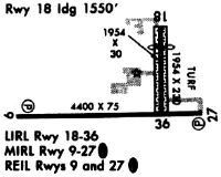
Runways
Runway Summary
| Runways: | 09/27 18/36 |
| Longest Runway: | 09/27 is 4401 ft (1341 m) long |
| Runways with an Instrument Approach: |
KIWH Airport Runway Details
| Runway 09/27 | 4401 ft x 75 ft (1341 m x 23 m) | |
| Runway Length Source: | 3RD PARTY SURVEY as of 11/17/2009 | |
| Surface: | Concrete - Fair condition - Saw-cut or plastic grooved | |
| Runway Edge Lights: | Medium Intensity | |
Runway Weight Bearing Capacity (in thousands of pounds) |
||
| Single Wheel Landing Gear: | 27.0 | |
Runway 09 |
Runway 27 |
|
Elevation: |
793.4 | 791.7 |
Latitude: |
40-45-39.6725N | 40-45-40.2344N |
Longitude: |
085-48-28.5445W | 085-47-31.3578W |
|
Runway True Alignment: |
089 | 269 |
Glide Path Angle: |
3.0 degrees | 3.0 degrees |
Traffic Pattern: |
Left | Left |
Runway Markings Type: |
Nonprecision Instrument | Nonprecision Instrument |
Runway Markings Condition: |
Fair | Fair |
Object at End: |
ROAD | TREES |
Object Height: |
15 | 53 |
Distance from End: |
500 | 1380 |
Object Centerline Offset: |
0 ft. left and right of centerline | 0 ft. left and right of centerline |
Visual Glide Slope Indicators: |
2-Light PAPI On Left Side Of Runway | 2-Light PAPI On Left Side Of Runway |
REIL: |
Yes | Yes |
Touchdown Lights: |
No | No |
Centerline Lights: |
No | No |
Threshold Crossing Height: |
32 | 32 |
| Runway 18/36 | 1940 ft x 60 ft (591 m x 18 m) | |
| Runway Length Source: | 3RD PARTY SURVEY as of 11/17/2009 | |
| Surface: | Concrete - Fair condition - No special surface treatment | |
| Runway Edge Lights: | Low Intensity | |
Runway Weight Bearing Capacity (in thousands of pounds) |
||
| Single Wheel Landing Gear: | 27.0 | |
Runway 18 |
Runway 36 |
|
Elevation: |
790.4 | 792.8 |
Latitude: |
40-45-59.7858N | 40-45-40.6233N |
Longitude: |
085-47-45.6333W | 085-47-45.0455W |
|
Runway True Alignment: |
179 | 359 |
Glide Path Angle: |
0.0 degrees | 0.0 degrees |
Runway Markings Type: |
Basic | Basic |
Runway Markings Condition: |
Fair | Fair |
Object at End: |
TREES | TREES |
Object Height: |
84 | 60 |
Distance from End: |
1440 | 650 |
Object Centerline Offset: |
0 ft. left and right of centerline | 0 ft. left and right of centerline |
Threshold Elevation: |
791.3 | |
Displaced Threshold: |
403 | |
Threshold Latitude: |
40-45-55.8013N | |
Threshold Longitude: |
085-47-45.5111W |
Services
Airframe Repair: |
Major |
Powerplant Repair: |
Major |
Bottled Oxygen: |
High Pressure |
Bulk Oxygen: |
High Pressure |
Fuel Available: |
100LL, Jet A+ |
Landing Fees: |
No |
Parking: |
Hangars and tiedowns available |
Maps & Diagrams
KIWH Sectional
Flight Planning
at skyvector.com
at skyvector.com