Location
Latitude: |
42-12-30.4000N (42.208444) |
Longitude: |
075-58-46.6000W (-75.979611) |
Elevation: |
1635.6 feet MSL (499 m MSL) |
Magnetic Variation: |
11.9 W (as of April 2024 from WMM2020 model) |
Time Zone: |
UTC -5.0 (Standard Time) UTC -4.0 (Daylight Savings Time) |
From City: |
07 N.M. N of Binghamton, New York |
Found On: |
New York Chart |
FAA Region: |
AEA |
Contacts
Manager: |
Publicly owned: |
| MARK HEEFNER 2534 AIRPORT ROAD, #16 JOHNSON CITY, NY 13790 607-763-4471 |
BROOME COUNTY 2534 AIRPORT ROAD #16 JOHNSON CITY, NY 13790 607-763-4471 |
Operations
Airport Status: |
Operational |
Facility Use: |
Public |
Type: |
Airport |
Activation Date: |
09/1950 |
Control tower: |
Yes |
Attendance (Months/Days/Hours): |
Months/Days/Hours ALL/ALL/ALL |
Boundary ARTCC: |
ZNY (New York) |
Responsible ARTCC: |
ZNY (New York) |
Lighting Schedule: |
SEE RMK |
Segmented Circle Indicator: |
No |
Traffic Pattern Altitude (MSL): |
2636 feet (803 m) |
NOTAMs Facility: |
BGM |
NOTAM-D Service: |
Yes |
International Airport of Entry: |
No |
Customs Landing Rights: |
No |
Military Landing Rights: |
Yes |
Civil/Military Joint Use: |
No |
Aircraft Rescue and Firefighting: |
Class I ARFF Index: B Air Carrier Service: Scheduled Certification Date: 05/1973 |
Based Aircraft
| Single Engine: | 25 |
| Multi Engine: | 10 |
| Jet Engine: | 4 |
Annual Operations (as of 04/30/2023)
| Total Operations: | 17025 | |
| Commercial: | 463 | 2.7% |
| Air Taxi: | 1443 | 8.5% |
| GA Local: | 7266 | 42.7% |
| GA Itinerant: | 7441 | 43.7% |
| Military Aircraft: | 412 | 2.4% |
Communications
| CTAF: | 119.300 |
| Unicom: | 122.950 |
| Tower: | BINGHAMTON 119.3 239.25 Hrs: 0600-0000 |
| Clearance Del.: | 125.05 |
| Ground: | 121.9 |
| Approach: | BINGHAMTON 118.6 ;SFC TO 5000 FT 127.55 ;6000-8000 FT 257.625 Hrs: 0600-0000 NEW YORK ARTCC Hrs: 0000-0600 |
| Departure: | BINGHAMTON 118.6 ;SFC TO 5000 FT 127.55 ;6000-8000 FT 257.625 Hrs: 0600-0000 NEW YORK ARTCC Hrs: 0000-0600 |
| ATIS: | 128.15 Hrs: 24 |
| ASOS: | (607-729-8335) |
| TRSA: | 118.6 ;SFC TO 5000 FT |
| EMERG: | 243.0 |
| EMERG: | 121.5 |
| TRSA: | 257.625 |
| TRSA: | 127.55 ;6000-8000 FT |
- APCH/DEP SVC PRVDD BY NEW YORK ARTCC ON FREQS 132.175/298.9 (ELK MOUNTAIN RCAG) WHEN BINGHAMTON APCH CTL CLSD.
- FOR CLNC DEL WHEN ATCT CLSD CTC BUFFALO RADIO ON CFB RCO 122.1R 112.2T.
Fixed Based Operators (FBOs) & Fuel
(Click on a business for detail)
Please help us keep this information up to date. This is a FREE SERVICE just like everything else on Airport Guide! If you see that a business needs to be added, modified, or deleted please fill out our Update Form.
To add, modify, or delete a business click here.
Please help us keep this information up to date. This is a FREE SERVICE just like everything else on Airport Guide! If you see that a business needs to be added, modified, or deleted please fill out our Update Form.
Area Code: 607 |
| Business Name | Frequency | Phone | Fuel Grade |
|---|---|---|---|
| Miller Aviation, Inc.
Update FBO info |
770-1093 800-288-4228 | 100LL, Jet A |
Flight Service Stations
| Primary | Alternate | |
| FSS on Field: | N | |
| FSS Name (ID): | Buffalo(BUF) | |
| Frequency: | ||
| Toll Free Phone: | 1-800-WX-BRIEF |
Instrument Procedures / Charts
FAA Terminal Procedures valid from 0901Z 03/21/24 to 0901Z 04/18/24.
There are various types of charts available for an airport. They are listed in the Page Type column. Here is a legend for those types:
APD - Airport Diagram
DP - Departure Procedure Charts
HOT - Hot Spots
IAP - Instrument Approach Procedure Charts
MIN - Minimums
STAR - Standard Terminal Arrival Charts
| Page Type | Page Name | Volume | Action Since Last Cycle |
|---|---|---|---|
| APD | AIRPORT DIAGRAM | NE-2 | |
| IAP | ILS OR LOC RWY 16 | NE-2 | |
| IAP | ILS OR LOC RWY 34 | NE-2 | |
| IAP | RNAV (GPS) RWY 10 | NE-2 | |
| IAP | RNAV (GPS) RWY 16 | NE-2 | |
| IAP | RNAV (GPS) RWY 28 | NE-2 | Changed |
| IAP | RNAV (GPS) RWY 34 | NE-2 | Changed |
| MIN | ALTERNATE MINIMUMS | NE-2 | |
| MIN | TAKEOFF MINIMUMS | NE-2 |
Terminal Procedures are only available for airports in several countries with more being added all the time. If you are looking for a specific country's charts, please send an email to support(at)airportguide.com stating the country name. This will be used to prioritize the implementation.
Navigation Aids (Navaids) near BGM
| Dist (NM) | ID | Morse Code | Name | Type | Freq | True Hdg | Mag Hdg |
|---|---|---|---|---|---|---|---|
| 7.4 | BG | _ . . . _ _ . | Smite | NDB | 332 | 147 | 159 |
| 7.6 | CFB | _ . _ . . . _ . _ . . . | Binghamton | VOR-DME | 112.20 | 246 | 258 |
| 21.8 | IT | . . _ | Vrnah | NDB | 266 | 307 | 319 |
| 27.4 | ITH | . . _ . . . . | Ithaca | DME | 111.8 | 309 | 321 |
| 30.8 | HNK | . . . . _ . _ . _ | Hancock | VOR-DME | 116.80 | 106 | 118 |
| 34.9 | ALP | . _ . _ . . . _ _ . | Alpine | NDB | 245 | 273 | 285 |
| 35.5 | GGT | _ _ . _ _ . _ | Georgetown | TACAN | 117.80 | 10 | 22 |
| 36.3 | RKA | . _ . _ . _ . _ | Rockdale | VOR-DME | 112.60 | 64 | 76 |
| 45.5 | DNY | _ . . _ . _ . _ _ | Delancey | VOR-DME | 112.10 | 91 | 103 |
| 47.0 | ULW | . . _ . _ . . . _ _ | Elmira | VOR-DME | 109.65 | 261 | 273 |
| 49.3 | LHY | . _ . . . . . . _ . _ _ | Lake Henry | VORTAC | 110.80 | 153 | 165 |
| 49.5 | OZ | _ _ _ _ _ . . | Kring | NDB | 279 | 62 | 74 |
| 54.4 | PYA | . _ _ . _ . _ _ . _ | Penn Yan | NDB | 260 | 299 | 311 |
| 56.5 | MS | _ _ . . . | Monga | NDB | 359 | 117 | 129 |
| 57.6 | LVZ | . _ . . . . . _ _ _ . . | Wilkes-Barre | VORTAC | 111.60 | 166 | 178 |
| 58.0 | SYR | . . . _ . _ _ . _ . | Syracuse | VORTAC | 117.00 | 350 | 362 |
| 60.9 | UCA | . . _ _ . _ . . _ | Utica | TACAN | 111.20 | 35 | 47 |
| 63.2 | FQM | . . _ . _ _ . _ _ _ | Williamsport | VOR-DME | 114.40 | 214 | 226 |
| 64.7 | PIX | . _ _ . . . _ . . _ | Picture Rocks | NDB | 344 | 210 | 222 |
| 66.3 | FZ | . . _ . _ _ . . | Falln | NDB | 220 | 347 | 359 |
Nearby Airports with Fuel
Notices to Airmen (NOTAMS)
Remarks
| A110-1 | ATCT UNABLE TO SEE HARD SFC SOUTH OF FBO HANGAR. |
| A110-2 | EXTENSIVE GLIDER ACTIVITY 10 NM SW OF ARPT. |
| A110-4 | BIRD ACTIVITY ON AND INVOF ARPT. |
| A110-5 | LGTD STRUCTURE 118 FT AGL 2000 FT SOUTH OF AER 10. |
| A110-6 | FOR CD IF UNA TO CTC ON FSS FREQ, CTC NEW YORK ARTCC AT 631-468-1425. |
| A17 | FBO SVCS AVBL 0430-2200 SUN TO SAT. FOR AFT HRS FBO SVCS CTC 607-643-1640. |
| A24 | LNDG FEE FOR MULTI-ENGINE & TURBINE ACFT OVER 4000 LBS. US CUSTOMS USER FEE ARPT. |
| A26 | PPR 12 HRS FOR UNSKED ACR OPNS WITH MORE THAN 9 PSGR SEATS 2300-0600 CALL AMGR 607-763-4474. ARFF AVBL 0530-0000 AND/OR UNTIL 15 MIN AFTER THE LAST SKED AIR CARRIER OPN. |
| A30-10/28 | RWY 10 TKOFS AND LDGS NA WHEN ATCT CLSD. |
| A30-H1 | HELIPAD LOCATED AT THE INTERSECTION OF TWY 'L' & THE WEST APRON. |
| A81-APT | WHEN ATCT CLSD ACTVT MALSR RWY 16 & 34; HIRL RWY 16/34; MIRL RWY 10/28; TWY LGTS - CTAF. |
| A81-BCN | DUSK-DAWN. |
| E60-16 | ENGINEERED MATERIALS ARRESTING SYSTEM (EMAS) 315 FT IN LENGTH BY 161 FT IN WIDTH LCTD AT THE DER 16. |
| E60-34 | ENGINEERED MATERIALS ARRESTING SYSTEM (EMAS) 311 FT IN LENGTH BY 161 FT WIDTH LCTD AT DER 34. |
| E80 | US CUSTOMS USER FEE ARPT. |
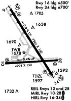
Runways
Runway Summary
| Runways: | 10/28 16/34 H1 |
| Longest Runway: | 16/34 is 7305 ft (2227 m) long |
| Runways with an Instrument Approach: | 16, 34 |
BGM Airport Runway Details
| Runway 10/28 | 5001 ft x 150 ft (1524 m x 46 m) | |
| Runway Length Source: | 3RD PARTY SURVEY as of 12/03/2018 | |
| Surface: | Asphalt - Excellent condition - Saw-cut or plastic grooved | |
| Runway Pavement Class: | 32 /F/D/X/T | |
| Runway Edge Lights: | Medium Intensity | |
Runway Weight Bearing Capacity (in thousands of pounds) |
||
| Single Wheel Landing Gear: | 81.0 | |
| Dual Wheel Landing Gear: | 103.0 | |
| Dual Tandem Wheel Landing Gear: | 168.0 | |
Runway 10 |
Runway 28 |
|
Elevation: |
1591.0 | 1572.1 |
Latitude: |
42-12-18.1762N | 42-12-21.1445N |
Longitude: |
075-59-19.9681W | 075-58-13.6429W |
|
Runway True Alignment: |
086 | 266 |
Glide Path Angle: |
3.0 degrees | 3.0 degrees |
Traffic Pattern: |
Left | Left |
Runway Markings Type: |
Nonprecision Instrument | Nonprecision Instrument |
Runway Markings Condition: |
Good | Good |
Visual Glide Slope Indicators: |
4-Box VASI On Left Side Of Runway | 4-Box VASI On Left Side Of Runway |
REIL: |
No | Yes |
Threshold Crossing Height: |
53 | 45 |
Declared Distances |
||
Take Off Run Avbl. (TORA): |
5001 | 5001 |
Take Off Distance Avbl. (TODA): |
5001 | 5001 |
Actual Stop Dist. Avbl. (ASDA): |
5001 | 5001 |
Landing Dist. Avbl. (LDA): |
5001 | 5001 |
| Runway 16/34 | 7305 ft x 150 ft (2227 m x 46 m) | |
| Runway Length Source: | 3RD PARTY SURVEY as of 12/03/2018 | |
| Surface: | Asphalt - Excellent condition - Saw-cut or plastic grooved | |
| Runway Pavement Class: | 45 /F/D/X/T | |
| Runway Edge Lights: | High Intensity | |
Runway Weight Bearing Capacity (in thousands of pounds) |
||
| Single Wheel Landing Gear: | 112.0 | |
| Dual Wheel Landing Gear: | 147.0 | |
| Dual Tandem Wheel Landing Gear: | 221.0 | |
Runway 16 |
Runway 34 |
|
Elevation: |
1635.6 | 1566.8 |
Latitude: |
42-13-08.4451N | 42-12-07.0466N |
Longitude: |
075-59-11.9272W | 075-58-20.9438W |
|
Runway True Alignment: |
148 | 328 |
ILS Type: |
ILS | ILS |
Glide Path Angle: |
3.0 degrees | 3.0 degrees |
Runway Markings Type: |
Precision Instrument | Precision Instrument |
Runway Markings Condition: |
Good | Good |
Arresting Device: |
EMAS | EMAS |
Object at End: |
ANT | |
Object Height: |
7 | |
Object Marked/Lighted?: |
Lighted | |
Distance from End: |
225 | |
Visual Glide Slope Indicators: |
2-Light PAPI On Left Side Of Runway | 2-Light PAPI On Left Side Of Runway |
Runway Visual Range (RVR): |
Touchdown, Rollout | Touchdown, Rollout |
Approach Light System: |
1,400 Foot Medium Intensity Approach Lighting System With Runway Alignment Indicator Lights | 1,400 Foot Medium Intensity Approach Lighting System With Runway Alignment Indicator Lights |
Threshold Crossing Height: |
61 | 64 |
Threshold Elevation: |
1633.8 | 1569.3 |
Displaced Threshold: |
400 | 205 |
Threshold Latitude: |
42-13-05.0857N | 42-12-08.7720N |
Threshold Longitude: |
075-59-09.1338W | 075-58-22.3711W |
Declared Distances |
||
Take Off Run Avbl. (TORA): |
7305 | 7305 |
Take Off Distance Avbl. (TODA): |
7305 | 7305 |
Actual Stop Dist. Avbl. (ASDA): |
7305 | 7305 |
Landing Dist. Avbl. (LDA): |
6905 | 7100 |
| Helipad H1 | 54 ft x 54 ft (16 m x 16 m) | |
| Runway Length Source: | OWNER as of 08/30/2013 | |
| Surface: | Asphalt - Excellent condition - No special surface treatment | |
| Runway Edge Lights: | Perimeter lights (for helipads) Intensity | |
Helipad H1 |
||
Elevation: |
1591.0 | |
Latitude: |
42-12-23.5000N | |
Longitude: |
075-59-02.8200W | |
Glide Path Angle: |
0.0 degrees | 0.0 degrees |
Runway Markings Type: |
Basic | |
Runway Markings Condition: |
Good |
Services
Airframe Repair: |
Major |
Powerplant Repair: |
Minor |
Bottled Oxygen: |
None |
Bulk Oxygen: |
None |
Fuel Available: |
100LL, Jet A |
Landing Fees: |
Yes |
Parking: |
Hangars and tiedowns available |
Maps & Diagrams
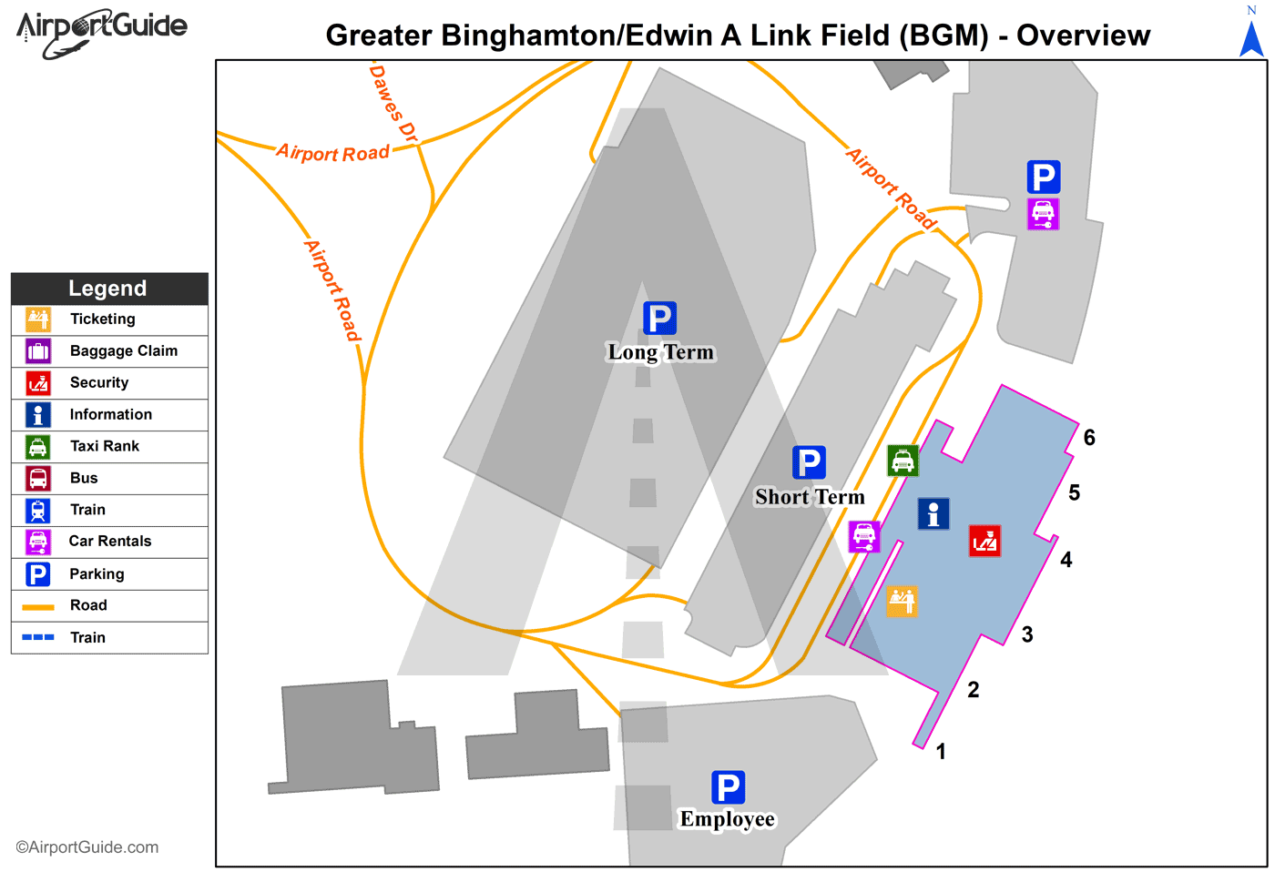
BGM Sectional
Flight Planning
at skyvector.com
at skyvector.com