Location
Latitude: |
42-37-45.2730N (42.629243) |
Longitude: |
074-53-27.5560W (-74.890988) |
Elevation: |
1260.0 feet MSL (384 m MSL) |
Magnetic Variation: |
12.5 W (as of April 2024 from WMM2020 model) |
Time Zone: |
UTC -5.0 (Standard Time) UTC -4.0 (Daylight Savings Time) |
From City: |
04 N.M. SE of Cooperstown, New York |
Found On: |
New York Chart |
FAA Region: |
AEA |
Contacts
Manager: |
Privately owned: |
| RICK WILLIAMS BODEE AVIATION, LLC, PO BOX 52 COOPERSTOWN, NY 13326 607-437-8308 |
RICK WILLIAMS 866 ST. RT. 166, PO BOX 52, PO BOX 1285 COOPERSTOWN, NY 13326-8661 (607) 437-8308 |
Operations
Airport Status: |
Operational |
Facility Use: |
Public |
Type: |
Airport |
Activation Date: |
05/1956 |
Control tower: |
No |
Attendance (Months/Days/Hours): |
Months/Days/Hours Unattended |
Boundary ARTCC: |
ZBW (Boston) |
Responsible ARTCC: |
ZBW (Boston) |
Lighting Schedule: |
SEE RMK |
Segmented Circle Indicator: |
Yes |
Traffic Pattern Altitude (MSL): |
2260 feet (689 m) |
NOTAMs Facility: |
BUF |
NOTAM-D Service: |
Yes |
International Airport of Entry: |
No |
Customs Landing Rights: |
No |
Military Landing Rights: |
No |
Civil/Military Joint Use: |
No |
Based Aircraft
| Single Engine: | 16 |
| Ultralights: | 6 |
Annual Operations (as of 08/23/2017)
| Total Operations: | 2400 | |
| GA Local: | 1200 | 50.0% |
| GA Itinerant: | 1200 | 50.0% |
Communications
| CTAF: | 122.800 |
| Unicom: | 122.800 |
Fixed Based Operators (FBOs) & Fuel
(Click on a business for detail)
Please help us keep this information up to date. This is a FREE SERVICE just like everything else on Airport Guide! If you see that a business needs to be added, modified, or deleted please fill out our Update Form.
To add, modify, or delete a business click here.
Please help us keep this information up to date. This is a FREE SERVICE just like everything else on Airport Guide! If you see that a business needs to be added, modified, or deleted please fill out our Update Form.
Area Code: 607 |
| Business Name | Frequency | Phone | Fuel Grade |
|---|---|---|---|
| Cooperstown-Westville Airport
Update FBO info |
286-9013 |
Flight Service Stations
| Primary | Alternate | |
| FSS on Field: | N | |
| FSS Name (ID): | Buffalo(BUF) | |
| Frequency: | ||
| Toll Free Phone: | 1-800-WX-BRIEF |
Instrument Procedures / Charts
Terminal Procedures are only available for airports in several countries with more being added all the time. If you are looking for a specific country's charts, please send an email to support(at)airportguide.com stating the country name. This will be used to prioritize the implementation.
Navigation Aids (Navaids) near COP
| Dist (NM) | ID | Morse Code | Name | Type | Freq | True Hdg | Mag Hdg |
|---|---|---|---|---|---|---|---|
| 5.0 | OZ | _ _ _ _ _ . . | Kring | NDB | 279 | 237 | 250 |
| 18.2 | RKA | . _ . _ . _ . _ | Rockdale | VOR-DME | 112.60 | 237 | 249 |
| 26.7 | UCA | . . _ _ . _ . . _ | Utica | TACAN | 111.20 | 333 | 346 |
| 27.2 | DNY | _ . . _ . _ . _ _ | Delancey | VOR-DME | 112.10 | 186 | 198 |
| 33.2 | JJH | . _ _ _ . _ _ _ . . . . | Johnstown | NDB | 523 | 47 | 60 |
| 38.9 | HNK | . . . . _ . _ . _ | Hancock | VOR-DME | 116.80 | 209 | 221 |
| 42.4 | GGT | _ _ . _ _ . _ | Georgetown | TACAN | 117.80 | 283 | 295 |
| 44.3 | HEU | . . . . . . . _ | Hunter | NDB | 356 | 71 | 84 |
| 47.6 | ALB | . _ . _ . . _ . . . | Albany | VOT | 108.20 | 81 | 94 |
| 48.5 | ALB | . _ . _ . . _ . . . | Albany | VORTAC | 115.30 | 81 | 94 |
| 51.8 | MS | _ _ . . . | Monga | NDB | 359 | 178 | 190 |
| 54.4 | BG | _ . . . _ _ . | Smite | NDB | 332 | 234 | 246 |
| 56.4 | PFH | . _ _ . . . _ . . . . . | Philmont | NDB | 272 | 113 | 126 |
| 62.0 | CFB | _ . _ . . . _ . _ . . . | Binghamton | VOR-DME | 112.20 | 243 | 255 |
| 66.0 | SYR | . . . _ . _ _ . _ . | Syracuse | VORTAC | 117.00 | 299 | 311 |
| 66.4 | IT | . . _ | Vrnah | NDB | 266 | 260 | 272 |
| 67.8 | GF | _ _ . . . _ . | Ganse | NDB | 209 | 55 | 68 |
| 69.8 | ITH | . . _ . . . . | Ithaca | DME | 111.8 | 263 | 275 |
| 70.6 | GFL | _ _ . . . _ . . _ . . | Glens Falls | VORTAC | 110.20 | 52 | 65 |
| 71.1 | GBR | _ _ . _ . . . . _ . | Great Barrington | NDB | 395 | 111 | 124 |
Nearby Airports with Fuel
Notices to Airmen (NOTAMS)
Remarks
| A110-1 | FOR CD CTC BOSTON ARTCC AT 603-879-6859. |
| A17 | CALL MGR FOR SERVICES. |
| A32-02/20 | RWY EDGE MKD BY YELLOW TIRES ARND EDGE LGTS. |
| A40-02/20 | NSTD MIRL; SPACING; 2 THLD LGTS EACH SIDE. |
| A50-02 | RWY 02; +60 FT TREE, 359 FT FROM THRESHOLD, 145 FT LEFT |
| A50-20 | RWY 20; +37 FT POLE, 394 FT FROM THRESHOLD, 163 FT RIGHT |
| A70-FUEL-10 | 0LL ATNDD ONLY. |
| A81-APT | ACTVT MIRL RY 02/20 - CTAF. |
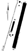
Runways
Runway Summary
| Runways: | 02/20 |
| Longest Runway: | 02/20 is 2337 ft (712 m) long |
| Runways with an Instrument Approach: |
COP Airport Runway Details
| Runway 02/20 | 2337 ft x 125 ft (712 m x 38 m) | |
| Surface: | Turf - Fair condition - No special surface treatment | |
| Runway Edge Lights: | Non-standard lighting system Intensity | |
Runway 02 |
Runway 20 |
|
Glide Path Angle: |
0.0 degrees | 0.0 degrees |
Traffic Pattern: |
Right | Left |
Object at End: |
TREES | CROPS |
Object Height: |
33 | 9 |
Distance from End: |
46 | 51 |
Object Centerline Offset: |
80 ft. right of centerline | 1 ft. left and right of centerline |
Visual Glide Slope Indicators: |
Nonstandard VASI System | Nonstandard VASI System |
Services
Airframe Repair: |
None |
Powerplant Repair: |
None |
Bottled Oxygen: |
None |
Bulk Oxygen: |
None |
Fuel Available: |
100LL |
Landing Fees: |
No |
Parking: |
Hangars and tiedowns available |
Maps & Diagrams
COP Sectional
Flight Planning
at skyvector.com
at skyvector.com