Location
Latitude: |
42-38-13.5000N (42.637083) |
Longitude: |
077-03-10.3000W (-77.052861) |
Elevation: |
988.0 feet MSL (301 m MSL) |
Magnetic Variation: |
11.4 W (as of April 2024 from WMM2020 model) |
Time Zone: |
UTC -5.0 (Standard Time) UTC -4.0 (Daylight Savings Time) |
From City: |
01 N.M. S of Penn Yan, New York |
Found On: |
Detroit Chart |
FAA Region: |
AEA |
Contacts
Manager: |
Publicly owned: |
| RICHARD LEPPERT 2262 AIRPORT DR. PENN YAN, NY 14527 315-536-4471 |
YATES COUNTY COUNTY BUILDING PENN YAN, NY 14527 315-536-5150 |
Operations
Airport Status: |
Operational |
Facility Use: |
Public |
Type: |
Airport |
Activation Date: |
10/1941 |
Control tower: |
No |
Attendance (Months/Days/Hours): |
Months/Days/Hours ALL/MON-FRI/0800-1700 |
Boundary ARTCC: |
ZOB (Cleveland) |
Responsible ARTCC: |
ZNY (New York) |
Lighting Schedule: |
SEE RMK |
Segmented Circle Indicator: |
No |
Traffic Pattern Altitude (MSL): |
1988 feet (606 m) |
NOTAMs Facility: |
PEO |
NOTAM-D Service: |
Yes |
International Airport of Entry: |
No |
Customs Landing Rights: |
No |
Military Landing Rights: |
No |
Civil/Military Joint Use: |
No |
Based Aircraft
| Single Engine: | 49 |
| Jet Engine: | 5 |
| GA Helicopters: | 1 |
Annual Operations (as of 06/30/2018)
| Total Operations: | 19200 | |
| Air Taxi: | 3000 | 15.6% |
| GA Local: | 10200 | 53.1% |
| GA Itinerant: | 6000 | 31.2% |
Communications
| CTAF: | 123.000 |
| Unicom: | 123.000 |
| Approach: | ELMIRA 124.3 124.3 CLEVELAND ARTCC |
| Departure: | ELMIRA 124.3 124.3 CLEVELAND ARTCC |
| ASOS: | 121.175 (315-536-4102) |
- APCH/DEP SVC PRVDD BY CLEVELAND ARTCC ON FREQS 127.475/377.05 (WAYLAND RCAG) WHEN ELMIRA APCH CTL CLSD.
Fixed Based Operators (FBOs) & Fuel
(Click on a business for detail)
Please help us keep this information up to date. This is a FREE SERVICE just like everything else on Airport Guide! If you see that a business needs to be added, modified, or deleted please fill out our Update Form.
To add, modify, or delete a business click here.
Please help us keep this information up to date. This is a FREE SERVICE just like everything else on Airport Guide! If you see that a business needs to be added, modified, or deleted please fill out our Update Form.
Area Code: 315 |
| Business Name | Frequency | Phone | Fuel Grade |
|---|---|---|---|
| Penn Yan Aero Service
Update FBO info |
536-2333 | ||
| Penn Yan Flying Club, Inc.
Update FBO info |
536-9615 | ||
| Seneca Flight Operations
Update FBO info |
Unicom 123.0 | 536-4471 | 100LL, Jet A |
Flight Service Stations
| Primary | Alternate | |
| FSS on Field: | N | |
| FSS Name (ID): | Buffalo(BUF) | |
| Frequency: | ||
| Toll Free Phone: | 1-800-WX-BRIEF |
Instrument Procedures / Charts
FAA Terminal Procedures valid from 0901Z 03/21/24 to 0901Z 04/18/24.
There are various types of charts available for an airport. They are listed in the Page Type column. Here is a legend for those types:
APD - Airport Diagram
DP - Departure Procedure Charts
HOT - Hot Spots
IAP - Instrument Approach Procedure Charts
MIN - Minimums
STAR - Standard Terminal Arrival Charts
| Page Type | Page Name | Volume | Action Since Last Cycle |
|---|---|---|---|
| IAP | RNAV (GPS) RWY 01 | NE-2 | Changed |
| IAP | RNAV (GPS) RWY 19 | NE-2 | Changed |
| MIN | ALTERNATE MINIMUMS | NE-2 | Changed |
| MIN | TAKEOFF MINIMUMS | NE-2 | Changed |
Terminal Procedures are only available for airports in several countries with more being added all the time. If you are looking for a specific country's charts, please send an email to support(at)airportguide.com stating the country name. This will be used to prioritize the implementation.
Navigation Aids (Navaids) near KPEO
| Dist (NM) | ID | Morse Code | Name | Type | Freq | True Hdg | Mag Hdg |
|---|---|---|---|---|---|---|---|
| 0.4 | PYA | . _ _ . _ . _ _ . _ | Penn Yan | NDB | 260 | 340 | 351 |
| 27.1 | ALP | . _ . _ . . . _ _ . | Alpine | NDB | 245 | 151 | 162 |
| 27.6 | ITH | . . _ . . . . | Ithaca | DME | 111.8 | 107 | 119 |
| 32.2 | GEE | _ _ . . . | Geneseo | VOR-DME | 108.20 | 291 | 302 |
| 32.6 | ULW | . . _ . _ . . . _ _ | Elmira | VOR-DME | 109.65 | 177 | 188 |
| 32.7 | IT | . . _ | Vrnah | NDB | 266 | 112 | 124 |
| 38.7 | AVN | . _ . . . _ _ . | Avon | NDB | 344 | 305 | 316 |
| 39.7 | ROC | . _ . _ _ _ _ . _ . | Rochester | VOR-DME | 110.00 | 316 | 327 |
| 48.7 | SYR | . . . _ . _ _ . _ . | Syracuse | VORTAC | 117.00 | 49 | 61 |
| 49.8 | CFB | _ . _ . . . _ . _ . . . | Binghamton | VOR-DME | 112.20 | 125 | 137 |
| 51.0 | FZ | . . _ . _ _ . . | Falln | NDB | 220 | 39 | 51 |
| 53.3 | ELZ | . . _ . . _ _ . . | Wellsville | DME | 115.85 | 232 | 243 |
| 54.8 | GGT | _ _ . _ _ . _ | Georgetown | TACAN | 117.80 | 80 | 92 |
| 58.8 | SFK | . . . . . _ . _ . _ | Stonyfork | VOR-DME | 108.60 | 196 | 207 |
| 60.6 | LYS | . _ . . _ . _ _ . . . | Olean | NDB | 360 | 249 | 260 |
| 60.6 | BG | _ . . . _ _ . | Smite | NDB | 332 | 121 | 133 |
| 72.3 | BUF | _ . . . . . _ . . _ . | Buffalo | DME | 116.4 | 284 | 295 |
| 73.6 | BU | _ . . . . . _ | Klump | NDB | 231 | 287 | 298 |
| 76.2 | BUF | _ . . . . . _ . . _ . | Buffalo | VOT | 109.00 | 284 | 295 |
| 78.9 | SLT | . . . . _ . . _ | Slate Run | VORTAC | 113.90 | 211 | 222 |
Nearby Airports with Fuel
Notices to Airmen (NOTAMS)
Remarks
| A110-1 | ADF APCH RWY 10/28 TRANSITIONARY AT 700'. |
| A110-2 | FOR CD CTC ELMYRA APCH AT 607-739-1971, WHEN APCH CLSD CTC CLEVELAND ARTCC AT 440-774-0231. |
| A110-3 | DUE TO TOPOGRAPHY, ACFT TO ACFT GND COMS LTD. ACFT CANNOT BE SEEN OR HEARD ON OPPOSITE ENDS OF RWY 01/19. USE EXTRM CTN. |
| A110-4 | TYPE I & TYPE IV DE-ICE AVBL. |
| A110-5 | FBO LCTD CNTR FLD. LOBBY ACES 24/7. |
| A39-10/28 | THE PAVEMENT SECTION FOR RWY 10/28 IS GREATER THAN THE REQUIRED THICKNESS FOR THE FLEET OF AIRCRAFT THAT CURRENTLY UTILIZE THE RWY. THE PCN LISTED IS THE LARGEST AIRCRAFT CLASSIFICATION NUMBER FOR THE CURRENT AIRCRAFT USING RUNWAY 10/28. |
| A57-10 | RWY 10 APCH RATIO 19:1 TO DTHR. |
| A57-28 | RWY 28 APCH RATIO 23:1 TO DTHR. |
| A58-10 | RWY 10 HAS +16 FT BLDG 59 FT FROM RWY END 95 FT LT; +14 FT BLDG, 123 FT FROM RWY, 60 FT LT; +8 FT FENCE 18 FT FROM RWY END BOTH SIDES AND CENTER. |
| A58-28 | RWY 28 HAS +32 FT TREE 113 FT FROM RWY END 121 FT LEFT; +13 FT FENCE 13 FT FROM RWY END BOTH SIDES. |
| A70-FUEL-10 | 0LL SELF SVC AVBL 24/7. |
| A71 | HELICOPTER AIRFRAME REPAIRS |
| A76 | CPU, LAV |
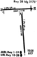
| A81-APT | ACTVT PAPI RWY 01, 19, 10, 28; MIRL RWY 01/19; LIRL RWY 10/28 - CTAF. |
| E111 | EXISTED PRIOR TO 1959 |
Runways
Runway Summary
| Runways: | 01/19 10/28 |
| Longest Runway: | 01/19 is 5499 ft (1676 m) long |
| Runways with an Instrument Approach: |
KPEO Airport Runway Details
| Runway 01/19 | 5499 ft x 100 ft (1676 m x 30 m) | |
| Runway Length Source: | 3RD PARTY SURVEY as of 10/23/2014 | |
| Surface: | Asphalt - Good condition - Saw-cut or plastic grooved | |
| Runway Pavement Class: | 33 /F/C/Y/T | |
| Runway Edge Lights: | Medium Intensity | |
Runway Weight Bearing Capacity (in thousands of pounds) |
||
| Single Wheel Landing Gear: | 82.6 | |
| Dual Wheel Landing Gear: | 112.0 | |
| Dual Tandem Wheel Landing Gear: | 195.0 | |
Runway 01 |
Runway 19 |
|
Elevation: |
988.0 | 915.9 |
Latitude: |
42-37-33.1031N | 42-38-27.3348N |
Longitude: |
077-03-05.7089W | 077-03-09.6795W |
|
Runway True Alignment: |
357 | 177 |
Glide Path Angle: |
3.0 degrees | 3.0 degrees |
Runway Markings Type: |
Nonprecision Instrument | Nonprecision Instrument |
Runway Markings Condition: |
Good | Good |
Object at End: |
FENCE | TREES |
Object Height: |
20 | 51 |
Distance from End: |
472 | 1344 |
Object Centerline Offset: |
73 ft. left of centerline | 306 ft. left of centerline |
Visual Glide Slope Indicators: |
2-Light PAPI On Left Side Of Runway | 2-Light PAPI On Left Side Of Runway |
REIL: |
Yes | Yes |
Threshold Crossing Height: |
28 | 40 |
| Runway 10/28 | 3561 ft x 50 ft (1085 m x 15 m) | |
| Runway Length Source: | 3RD PARTY SURVEY as of 10/23/2014 | |
| Surface: | Asphalt - Good condition - No special surface treatment | |
| Runway Pavement Class: | 4 /F/B/X/U | |
| Runway Edge Lights: | Low Intensity | |
Runway Weight Bearing Capacity (in thousands of pounds) |
||
| Single Wheel Landing Gear: | 12.5 | |
Runway 10 |
Runway 28 |
|
Elevation: |
845.1 | 902.9 |
Latitude: |
42-38-33.6320N | 42-38-34.5139N |
Longitude: |
077-03-38.1162W | 077-02-50.4972W |
|
Runway True Alignment: |
088 | 268 |
Glide Path Angle: |
3.0 degrees | 3.5 degrees |
Traffic Pattern: |
Left | Left |
Runway Markings Type: |
Nonprecision Instrument | Nonprecision Instrument |
Runway Markings Condition: |
Good | Good |
Object at End: |
POLE | POLE |
Object Height: |
30 | 30 |
Distance from End: |
226 | 334 |
Object Centerline Offset: |
73 ft. left of centerline | 306 ft. left of centerline |
Visual Glide Slope Indicators: |
2-Light PAPI On Left Side Of Runway | 2-Light PAPI On Right Side Of Runway |
REIL: |
No | No |
Touchdown Lights: |
No | No |
Centerline Lights: |
No | No |
Threshold Crossing Height: |
40 | 43 |
Threshold Elevation: |
857.1 | 900.3 |
Displaced Threshold: |
361 | 383 |
Threshold Latitude: |
42-38-33.7212N | 42-38-34.4190N |
Threshold Longitude: |
077-03-33.2925W | 077-02-55.6249W |
Services
Airframe Repair: |
Major |
Powerplant Repair: |
Major |
Bottled Oxygen: |
None |
Bulk Oxygen: |
High Pressure |
Fuel Available: |
100LL, Jet A-1+ |
Landing Fees: |
No |
Parking: |
Hangars and tiedowns available |
Maps & Diagrams
KPEO Sectional
Flight Planning
at skyvector.com
at skyvector.com