Location
Latitude: |
42-29-28.9000N (42.491361) |
Longitude: |
076-27-31.4000W (-76.458722) |
Elevation: |
1099.0 feet MSL (335 m MSL) |
Magnetic Variation: |
11.7 W (as of April 2024 from WMM2020 model) |
Time Zone: |
UTC -5.0 (Standard Time) UTC -4.0 (Daylight Savings Time) |
From City: |
03 N.M. NE of Ithaca, New York |
Found On: |
New York Chart |
FAA Region: |
AEA |
Contacts
Manager: |
Publicly owned: |
| ROXAN NOBLE 72 BROWN RD ITHACA, NY 14850 607-257-0456 |
TOMPKINS COUNTY 125 EAST COURT ST ITHACA, NY 14850 607-274-5551 |
Operations
Airport Status: |
Operational |
Facility Use: |
Public |
Type: |
Airport |
Activation Date: |
10/1947 |
Control tower: |
Yes |
Attendance (Months/Days/Hours): |
Months/Days/Hours ALL/ALL/0500-0000 |
Boundary ARTCC: |
ZNY (New York) |
Responsible ARTCC: |
ZNY (New York) |
Lighting Schedule: |
SEE RMK |
Segmented Circle Indicator: |
No |
Traffic Pattern Altitude (MSL): |
2099 feet (640 m) |
NOTAMs Facility: |
ITH |
NOTAM-D Service: |
Yes |
International Airport of Entry: |
No |
Customs Landing Rights: |
No |
Military Landing Rights: |
Yes |
Civil/Military Joint Use: |
No |
Aircraft Rescue and Firefighting: |
Class I ARFF Index: C Air Carrier Service: Scheduled Certification Date: 05/1973 |
Based Aircraft
| Single Engine: | 34 |
| Multi Engine: | 6 |
| Jet Engine: | 14 |
Annual Operations (as of 04/30/2023)
| Total Operations: | 36641 | |
| Air Taxi: | 4100 | 11.2% |
| GA Local: | 10194 | 27.8% |
| GA Itinerant: | 22027 | 60.1% |
| Military Aircraft: | 320 | 0.9% |
Communications
| CTAF: | 119.600 |
| Unicom: | 122.950 |
| Tower: | ITHACA 119.6 Hrs: 0530-2100 |
| Clearance Del.: | 121.8 |
| Ground: | 121.8 |
| Approach: | ELMIRA 124.3 124.3 NEW YORK ARTCC |
| Departure: | ELMIRA 124.3 124.3 NEW YORK ARTCC |
| ATIS: | 125.175 Hrs: 24 |
| AWOS-3PT: | 125.175 (607-257-2390) |
| EMERG: | 121.5 |
- APCH/DEP SVC PRVDD BY NEW YORK ARTCC ON FREQS 133.35/372.0 (SAYRE RCAG) WHEN ELMIRA APCH CTL CLSD.
- FOR CLNC DEL WHEN ATCT CLSD CTC ELMIRA APCH ON 124.3.
Fixed Based Operators (FBOs) & Fuel
(Click on a business for detail)
Please help us keep this information up to date. This is a FREE SERVICE just like everything else on Airport Guide! If you see that a business needs to be added, modified, or deleted please fill out our Update Form.
To add, modify, or delete a business click here.
Please help us keep this information up to date. This is a FREE SERVICE just like everything else on Airport Guide! If you see that a business needs to be added, modified, or deleted please fill out our Update Form.
Area Code: 607 |
| Business Name | Frequency | Phone | Fuel Grade |
|---|---|---|---|
| East Hill Flying Club
Update FBO info |
Unicom 123.5 | 257-1313 | 100LL |
| Taughannock Aviation Corp.
Update FBO info |
Unicom 122.95 | 257-1666, -7500 | 100LL, Jet A |
Flight Service Stations
| Primary | Alternate | |
| FSS on Field: | N | |
| FSS Name (ID): | Buffalo(BUF) | |
| Frequency: | ||
| Toll Free Phone: | 1-800-WX-BRIEF |
Instrument Procedures / Charts
FAA Terminal Procedures valid from 0901Z 03/21/24 to 0901Z 04/18/24.
There are various types of charts available for an airport. They are listed in the Page Type column. Here is a legend for those types:
APD - Airport Diagram
DP - Departure Procedure Charts
HOT - Hot Spots
IAP - Instrument Approach Procedure Charts
MIN - Minimums
STAR - Standard Terminal Arrival Charts
| Page Type | Page Name | Volume | Action Since Last Cycle |
|---|---|---|---|
| APD | AIRPORT DIAGRAM | NE-2 | |
| IAP | ILS OR LOC RWY 32 | NE-2 | Changed |
| IAP | RNAV (GPS) RWY 32 | NE-2 | |
| IAP | RNAV (GPS) Y RWY 14 | NE-2 | Changed |
| IAP | RNAV (GPS) Z RWY 14 | NE-2 | |
| MIN | ALTERNATE MINIMUMS | NE-2 | |
| MIN | TAKEOFF MINIMUMS | NE-2 |
Terminal Procedures are only available for airports in several countries with more being added all the time. If you are looking for a specific country's charts, please send an email to support(at)airportguide.com stating the country name. This will be used to prioritize the implementation.
Navigation Aids (Navaids) near ITH
| Dist (NM) | ID | Morse Code | Name | Type | Freq | True Hdg | Mag Hdg |
|---|---|---|---|---|---|---|---|
| 0.2 | ITH | . . _ . . . . | Ithaca | DME | 111.8 | 348 | 360 |
| 5.4 | IT | . . _ | Vrnah | NDB | 266 | 132 | 144 |
| 20.3 | ALP | . _ . _ . . . _ _ . | Alpine | NDB | 245 | 221 | 233 |
| 24.6 | CFB | _ . _ . . . _ . _ . . . | Binghamton | VOR-DME | 112.20 | 144 | 156 |
| 27.9 | PYA | . _ _ . _ . _ _ . _ | Penn Yan | NDB | 260 | 289 | 301 |
| 33.1 | GGT | _ _ . _ _ . _ | Georgetown | TACAN | 117.80 | 57 | 69 |
| 34.2 | BG | _ . . . _ _ . | Smite | NDB | 332 | 132 | 144 |
| 34.6 | ULW | . . _ . _ . . . _ _ | Elmira | VOR-DME | 109.65 | 226 | 238 |
| 41.7 | SYR | . . . _ . _ _ . _ . | Syracuse | VORTAC | 117.00 | 15 | 27 |
| 48.3 | FZ | . . _ . _ _ . . | Falln | NDB | 220 | 8 | 20 |
| 54.0 | RKA | . _ . _ . _ . _ | Rockdale | VOR-DME | 112.60 | 91 | 103 |
| 56.9 | HNK | . . . . _ . _ . _ | Hancock | VOR-DME | 116.80 | 116 | 128 |
| 59.9 | GEE | _ _ . . . | Geneseo | VOR-DME | 108.20 | 290 | 301 |
| 64.1 | SFK | . . . . . _ . _ . _ | Stonyfork | VOR-DME | 108.60 | 222 | 233 |
| 65.3 | OZ | _ _ _ _ _ . . | Kring | NDB | 279 | 84 | 96 |
| 65.3 | ROC | . _ . _ _ _ _ . _ . | Rochester | VOR-DME | 110.00 | 305 | 316 |
| 65.4 | UCA | . . _ _ . _ . . _ | Utica | TACAN | 111.20 | 60 | 72 |
| 65.6 | AVN | . _ . . . _ _ . | Avon | NDB | 344 | 298 | 309 |
| 69.2 | DNY | _ . . _ . _ . _ _ | Delancey | VOR-DME | 112.10 | 105 | 117 |
| 70.6 | FQM | . . _ . _ _ . _ _ _ | Williamsport | VOR-DME | 114.40 | 191 | 203 |
Nearby Airports with Fuel
Notices to Airmen (NOTAMS)
Remarks
| A110-4 | DEER & FLOCKS OF BIRDS ON & INVOF ARPT. |
| A110-6 | COLD TEMPERATURE AIRPORT. ALTITUDE CORRECTION REQUIRED AT OR BELOW -19C. |
| A110-7 | FOR CD IF UNA TO CTC ON FSS FREQ, CTC NEW YORK ARTCC. |
| A110-8 | FOR CD WHEN TWR AND ELM APCH CLSD CTC NEW YORK ARTCC. |
| A17 | FBO AVBL 0600-1900; FBO SVCS CTC 131.6; AFT HRS CALL 607-279-0392 OR 800-876-1551. |
| A24 | LDG FEE FOR TSNT ACFT. |
| A26 | PPR 24 HRS FOR UNSKED ACFT OPS. CALL AMGR 607-257-6666. ARFF AVBL 0430-0000 AND/OR 15 MIN PRIOR TO OR 15 MIN AFT SKED ACR OPNS. |
| A30-15/33 | RWY 15/33 CLSD NGTS, WINTER MONTHS AND AFT HVY RAIN. |
| A42-15 | RWY 15/33 THRS MKD WITH WHITE LIME BAR; EDGES MKD WITH REFLECTORS. |
| A81-APT | WHEN ATCT CLSD ACTVT MALSR RWY 32; HIRL RWY 14/32; TWY LGTS - CTAF. PAPI RWYS 14 & 32 OPR CONSLY. |
| A82 | UNICOM UNMON. |
| E111 | FILED FOR RECORD PURPOSES ONLY. |
| E80 | US CUSTOMS USER FEE ARPT. |
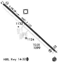
Runways
Runway Summary
| Runways: | 14/32 15/33 |
| Longest Runway: | 14/32 is 6977 ft (2127 m) long |
| Runways with an Instrument Approach: | 32 |
ITH Airport Runway Details
| Runway 14/32 | 6977 ft x 150 ft (2127 m x 46 m) | |
| Runway Length Source: | 3RD PARTY SURVEY as of 03/17/2011 | |
| Surface: | Asphalt - Good condition - Saw-cut or plastic grooved | |
| Runway Pavement Class: | 58 /F/C/W/T | |
| Runway Edge Lights: | High Intensity | |
Runway Weight Bearing Capacity (in thousands of pounds) |
||
| Single Wheel Landing Gear: | 100.0 | |
| Dual Wheel Landing Gear: | 192.0 | |
| Dual Tandem Wheel Landing Gear: | 574.0 | |
| Dual Dual Tandem Wheel Landing Gear: | 1044.0 | |
Runway 14 |
Runway 32 |
|
Elevation: |
1076.5 | 1099.0 |
Latitude: |
42-29-52.1934N | 42-29-05.6306N |
Longitude: |
076-28-06.5888W | 076-26-57.9537W |
|
Runway True Alignment: |
133 | 313 |
ILS Type: |
ILS | |
Glide Path Angle: |
3.0 degrees | 3.2 degrees |
Traffic Pattern: |
Left | Left |
Runway Markings Type: |
Precision Instrument | Precision Instrument |
Runway Markings Condition: |
Good | Good |
Object at End: |
TREES | |
Object Height: |
642 | |
Distance from End: |
20360 | |
Object Centerline Offset: |
2000 ft. right of centerline | |
Visual Glide Slope Indicators: |
4-Light PAPI On Left Side Of Runway | 4-Light PAPI On Left Side Of Runway |
Runway Visual Range (RVR): |
Rollout | Touchdown |
Approach Light System: |
1,400 Foot Medium Intensity Approach Lighting System With Runway Alignment Indicator Lights | |
Threshold Crossing Height: |
50 | 53 |
Declared Distances |
||
Take Off Run Avbl. (TORA): |
6977 | 6977 |
Take Off Distance Avbl. (TODA): |
6977 | 6977 |
Actual Stop Dist. Avbl. (ASDA): |
6602 | 6602 |
Landing Dist. Avbl. (LDA): |
6602 | 6602 |
| Runway 15/33 | 2018 ft x 50 ft (615 m x 15 m) | |
| Runway Length Source: | 3RD PARTY SURVEY as of 11/21/2008 | |
| Surface: | Asphalt - Good condition - No special surface treatment | |
Runway 15 |
Runway 33 |
|
Elevation: |
1080.5 | 1086.4 |
Latitude: |
42-29-35.7153N | 42-29-22.2469N |
Longitude: |
076-27-38.4353W | 076-27-18.5742W |
|
Runway True Alignment: |
132 | 313 |
Glide Path Angle: |
0.0 degrees | 0.0 degrees |
Object at End: |
ROAD | ANT |
Object Height: |
15 | 55 |
Object Marked/Lighted?: |
Lighted | |
Distance from End: |
238 | 1200 |
Object Centerline Offset: |
2000 ft. right of centerline |
Services
Airframe Repair: |
Major |
Powerplant Repair: |
Major |
Bottled Oxygen: |
None |
Bulk Oxygen: |
None |
Fuel Available: |
100LL |
Landing Fees: |
No |
Parking: |
Hangars and tiedowns available |
Maps & Diagrams
ITH Sectional
Flight Planning
at skyvector.com
at skyvector.com