Location
Latitude: |
41-44-24.0000N (41.74) |
Longitude: |
076-26-49.7000W (-76.447139) |
Elevation: |
730.3 feet MSL (223 m MSL) |
Magnetic Variation: |
11.6 W (as of April 2024 from WMM2020 model) |
Time Zone: |
UTC -5.0 (Standard Time) UTC -4.0 (Daylight Savings Time) |
From City: |
02 N.M. S of Towanda, Pennsylvania |
Found On: |
New York Chart |
FAA Region: |
AEA |
Contacts
Manager: |
Publicly owned: |
| SCOTT HAUSER 415 AIRPORT RD. TOWANDA, PA 18848 570-265-4900 |
BRADFORD COUNTY AIRPORT AUTHORITY 415 AIRPORT RD. TOWANDA, PA 18848 570-265-4900 |
Operations
Airport Status: |
Operational |
Facility Use: |
Public |
Type: |
Airport |
Activation Date: |
07/1938 |
Control tower: |
No |
Attendance (Months/Days/Hours): |
Months/Days/Hours ALL/M-F/0800-1700 |
Boundary ARTCC: |
ZNY (New York) |
Responsible ARTCC: |
ZNY (New York) |
Lighting Schedule: |
SEE RMK |
Segmented Circle Indicator: |
Yes |
Traffic Pattern Altitude (MSL): |
1730 feet (527 m) |
NOTAMs Facility: |
IPT |
NOTAM-D Service: |
Yes |
International Airport of Entry: |
No |
Customs Landing Rights: |
No |
Military Landing Rights: |
Yes |
Civil/Military Joint Use: |
No |
Based Aircraft
| Single Engine: | 36 |
| Multi Engine: | 2 |
Annual Operations (as of 10/25/2023)
| Total Operations: | 23100 | |
| GA Local: | 8000 | 34.6% |
| GA Itinerant: | 15000 | 64.9% |
| Military Aircraft: | 100 | 0.4% |
Communications
| CTAF: | 123.000 |
| Unicom: | 123.000 |
| Approach: | BINGHAMTON 118.6 118.6 NEW YORK ARTCC |
| Departure: | BINGHAMTON 118.6 118.6 NEW YORK ARTCC |
| AWOS-3: | 119.925 (570-265-1024) |
- APCH/DEP SVC PRVDD BY NEW YORK ARTCC ON FREQS 132.175/298.9 (ELK MOUNTAIN RCAG) WHEN BINGHAMTON APCH CTL CLSD.
Fixed Based Operators (FBOs) & Fuel
(Click on a business for detail)
Please help us keep this information up to date. This is a FREE SERVICE just like everything else on Airport Guide! If you see that a business needs to be added, modified, or deleted please fill out our Update Form.
To add, modify, or delete a business click here.
Please help us keep this information up to date. This is a FREE SERVICE just like everything else on Airport Guide! If you see that a business needs to be added, modified, or deleted please fill out our Update Form.
Area Code: 570 |
| Business Name | Frequency | Phone | Fuel Grade |
|---|---|---|---|
| Northern Tier Aviation Service
Update FBO info |
Unicom 122.8 | 265-4900 | 100LL |
Flight Service Stations
| Primary | Alternate | |
| FSS on Field: | N | |
| FSS Name (ID): | Williamsport(IPT) | |
| Frequency: | ||
| Toll Free Phone: | 1-800-WX-BRIEF |
Instrument Procedures / Charts
FAA Terminal Procedures valid from 0901Z 03/21/24 to 0901Z 04/18/24.
There are various types of charts available for an airport. They are listed in the Page Type column. Here is a legend for those types:
APD - Airport Diagram
DP - Departure Procedure Charts
HOT - Hot Spots
IAP - Instrument Approach Procedure Charts
MIN - Minimums
STAR - Standard Terminal Arrival Charts
| Page Type | Page Name | Volume | Action Since Last Cycle |
|---|---|---|---|
| IAP | RNAV (GPS) RWY 23 | NE-4 | |
| IAP | RNAV (GPS)-A | NE-4 | |
| MIN | TAKEOFF MINIMUMS | NE-4 |
Terminal Procedures are only available for airports in several countries with more being added all the time. If you are looking for a specific country's charts, please send an email to support(at)airportguide.com stating the country name. This will be used to prioritize the implementation.
Navigation Aids (Navaids) near N27
| Dist (NM) | ID | Morse Code | Name | Type | Freq | True Hdg | Mag Hdg |
|---|---|---|---|---|---|---|---|
| 28.2 | FQM | . . _ . _ _ . _ _ _ | Williamsport | VOR-DME | 114.40 | 211 | 222 |
| 28.6 | CFB | _ . _ . . . _ . _ . . . | Binghamton | VOR-DME | 112.20 | 28 | 40 |
| 30.2 | PIX | . _ _ . . . _ . . _ | Picture Rocks | NDB | 344 | 203 | 214 |
| 33.1 | BG | _ . . . _ _ . | Smite | NDB | 332 | 48 | 60 |
| 33.1 | ALP | . _ . _ . . . _ _ . | Alpine | NDB | 245 | 334 | 346 |
| 33.4 | ULW | . . _ . _ . . . _ _ | Elmira | VOR-DME | 109.65 | 309 | 320 |
| 41.6 | IT | . . _ | Vrnah | NDB | 266 | 4 | 16 |
| 43.6 | SFK | . . . . . _ . _ . _ | Stonyfork | VOR-DME | 108.60 | 266 | 277 |
| 44.1 | LVZ | . _ . . . . . _ _ _ . . | Wilkes-Barre | VORTAC | 111.60 | 129 | 141 |
| 44.1 | MIP | _ _ . . . _ _ . | Milton | VORTAC | 109.20 | 192 | 203 |
| 45.3 | ITH | . . _ . . . . | Ithaca | DME | 111.8 | 359 | 371 |
| 46.1 | LHY | . _ . . . . . . _ . _ _ | Lake Henry | VORTAC | 110.80 | 109 | 121 |
| 48.1 | HZL | . . . . _ _ . . . _ . . | Hazleton | VOR | 109.40 | 162 | 174 |
| 54.1 | HNK | . . . . _ . _ . _ | Hancock | VOR-DME | 116.80 | 68 | 80 |
| 60.3 | SEG | . . . . _ _ . | Selinsgrove | VOR-DME | 110.40 | 199 | 210 |
| 60.6 | PYA | . _ _ . _ . _ _ . _ | Penn Yan | NDB | 260 | 333 | 345 |
| 68.7 | GGT | _ _ . _ _ . _ | Georgetown | TACAN | 117.80 | 23 | 35 |
| 69.2 | RKA | . _ . _ . _ . _ | Rockdale | VOR-DME | 112.60 | 50 | 62 |
| 69.7 | SLT | . . . . _ . . _ | Slate Run | VORTAC | 113.90 | 259 | 270 |
| 71.0 | MS | _ _ . . . | Monga | NDB | 359 | 88 | 100 |
Nearby Airports with Fuel
Notices to Airmen (NOTAMS)
Remarks
| A110-3 | FOR CD CTC BINGHAMTON APCH AT 607-729-6146. WHEN APCH CLSD, CTC NEW YORK ARTCC AT 631-468-1425. |
| A17 | FOR SVC AFT HRS CALL 570-637-4902. |
| A75 | ACFT OWNER SUP OWN TIE-DOWNS. |
| A81-APT | ACTVT REIL RWY 05 & 23; PAPI RWY 05 & 23; MIRL RWY 05/23 - CTAF. |
Runways
Runway Summary
| Runways: | 05/23 |
| Longest Runway: | 05/23 is 4301 ft (1311 m) long |
| Runways with an Instrument Approach: |
N27 Airport Runway Details
| Runway 05/23 | 4301 ft x 75 ft (1311 m x 23 m) | |
| Runway Length Source: | 3RD PARTY SURVEY as of 11/01/2016 | |
| Surface: | Asphalt - Excellent condition - No special surface treatment | |
| Runway Edge Lights: | Medium Intensity | |
Runway Weight Bearing Capacity (in thousands of pounds) |
||
| Single Wheel Landing Gear: | 12.0 | |
Runway 05 |
Runway 23 |
|
Elevation: |
730.2 | 713.5 |
Latitude: |
41-44-06.6412N | 41-44-41.4356N |
Longitude: |
076-27-05.9644W | 076-26-33.3991W |
|
Runway True Alignment: |
035 | 215 |
Glide Path Angle: |
3.0 degrees | 3.0 degrees |
Traffic Pattern: |
Left | Left |
Runway Markings Type: |
Nonprecision Instrument | Nonprecision Instrument |
Runway Markings Condition: |
Good | Good |
Visual Glide Slope Indicators: |
2-Light PAPI On Left Side Of Runway | 2-Light PAPI On Left Side Of Runway |
REIL: |
Yes | Yes |
Threshold Crossing Height: |
37 | 37 |
Services
Airframe Repair: |
Major |
Powerplant Repair: |
Major |
Bottled Oxygen: |
High Pressure / Low Pressure |
Bulk Oxygen: |
None |
Fuel Available: |
100LL, Jet A |
Landing Fees: |
No |
Parking: |
Hangars and tiedowns available |
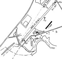
Maps & Diagrams
N27 Sectional
Flight Planning
at skyvector.com
at skyvector.com