Location
Latitude: |
42-54-50.2550N (42.91396) |
Longitude: |
076-26-26.7510W (-76.440764) |
Elevation: |
1039.0 feet MSL (317 m MSL) |
Magnetic Variation: |
11.8 W (as of April 2024 from WMM2020 model) |
Time Zone: |
UTC -5.0 (Standard Time) UTC -4.0 (Daylight Savings Time) |
From City: |
02 N.M. SW of Skaneateles, New York |
Found On: |
New York Chart |
FAA Region: |
AEA |
Contacts
Manager: |
Privately owned: |
| DANIEL ARNOLD 2984 BENSON ROAD SKANEATELES, NY 13152 707-580-9240 |
SKANEATELES AERODROME LLC 333 W. WASHINGTON ST STE 600 SYRACUSE, NY 13202 (315) 200-1877 |
Operations
Airport Status: |
Operational |
Facility Use: |
Public |
Type: |
Airport |
Activation Date: |
10/1948 |
Control tower: |
No |
Attendance (Months/Days/Hours): |
Months/Days/Hours Unattended; CALL MGR |
Boundary ARTCC: |
ZNY (New York) |
Responsible ARTCC: |
ZBW (Boston) |
Lighting Schedule: |
SEE RMK |
Segmented Circle Indicator: |
No |
Traffic Pattern Altitude (MSL): |
2039 feet (621 m) |
NOTAMs Facility: |
BUF |
NOTAM-D Service: |
Yes |
International Airport of Entry: |
No |
Customs Landing Rights: |
No |
Military Landing Rights: |
No |
Civil/Military Joint Use: |
No |
Based Aircraft
| Single Engine: | 23 |
| Multi Engine: | 2 |
Annual Operations (as of 07/20/2018)
| Total Operations: | 9108 | |
| GA Local: | 7500 | 82.3% |
| GA Itinerant: | 1600 | 17.6% |
| Military Aircraft: | 8 | 0.1% |
Communications
| CTAF: | 122.800 |
| Unicom: | 122.800 |
| Approach: | SYRACUSE 126.125 126.125 |
| Departure: | SYRACUSE 126.125 126.125 |
| AWOS-3P: | 120.125 (315-685-5790) |
Fixed Based Operators (FBOs) & Fuel
(Click on a business for detail)
Please help us keep this information up to date. This is a FREE SERVICE just like everything else on Airport Guide! If you see that a business needs to be added, modified, or deleted please fill out our Update Form.
To add, modify, or delete a business click here.
Please help us keep this information up to date. This is a FREE SERVICE just like everything else on Airport Guide! If you see that a business needs to be added, modified, or deleted please fill out our Update Form.
Area Code: 315 |
| Business Name | Frequency | Phone | Fuel Grade |
|---|---|---|---|
| Skaneateles Airport
Update FBO info |
Unicom 122.8 | 685-7737 | 80, 100LL |
Flight Service Stations
| Primary | Alternate | |
| FSS on Field: | N | |
| FSS Name (ID): | Buffalo(BUF) | |
| Frequency: | ||
| Toll Free Phone: | 1-800-WX-BRIEF |
Instrument Procedures / Charts
FAA Terminal Procedures valid from 0901Z 03/21/24 to 0901Z 04/18/24.
There are various types of charts available for an airport. They are listed in the Page Type column. Here is a legend for those types:
APD - Airport Diagram
DP - Departure Procedure Charts
HOT - Hot Spots
IAP - Instrument Approach Procedure Charts
MIN - Minimums
STAR - Standard Terminal Arrival Charts
| Page Type | Page Name | Volume | Action Since Last Cycle |
|---|---|---|---|
| IAP | RNAV (GPS)-A | NE-2 | |
| IAP | RNAV (GPS)-B | NE-2 | |
| MIN | ALTERNATE MINIMUMS | NE-2 | |
| MIN | TAKEOFF MINIMUMS | NE-2 |
Terminal Procedures are only available for airports in several countries with more being added all the time. If you are looking for a specific country's charts, please send an email to support(at)airportguide.com stating the country name. This will be used to prioritize the implementation.
Navigation Aids (Navaids) near 6B9
| Dist (NM) | ID | Morse Code | Name | Type | Freq | True Hdg | Mag Hdg |
|---|---|---|---|---|---|---|---|
| 18.1 | SYR | . . . _ . _ _ . _ . | Syracuse | VORTAC | 117.00 | 34 | 46 |
| 23.2 | FZ | . . _ . _ _ . . | Falln | NDB | 220 | 14 | 26 |
| 25.2 | ITH | . . _ . . . . | Ithaca | DME | 111.8 | 181 | 193 |
| 28.0 | GGT | _ _ . _ _ . _ | Georgetown | TACAN | 117.80 | 105 | 117 |
| 29.2 | IT | . . _ | Vrnah | NDB | 266 | 173 | 185 |
| 31.6 | PYA | . _ _ . _ . _ _ . _ | Penn Yan | NDB | 260 | 239 | 251 |
| 43.0 | ALP | . _ . _ . . . _ _ . | Alpine | NDB | 245 | 199 | 211 |
| 47.3 | CFB | _ . _ . . . _ . _ . . . | Binghamton | VOR-DME | 112.20 | 163 | 175 |
| 54.3 | BG | _ . . . _ _ . | Smite | NDB | 332 | 153 | 165 |
| 55.4 | ROC | . _ . _ _ _ _ . _ . | Rochester | VOR-DME | 110.00 | 283 | 295 |
| 55.6 | ULW | . . _ . _ . . . _ _ | Elmira | VOR-DME | 109.65 | 207 | 219 |
| 56.4 | UCA | . . _ _ . _ . . _ | Utica | TACAN | 111.20 | 82 | 94 |
| 57.0 | GEE | _ _ . . . | Geneseo | VOR-DME | 108.20 | 265 | 276 |
| 58.6 | AVN | . _ . . . _ _ . | Avon | NDB | 344 | 276 | 287 |
| 59.4 | RKA | . _ . _ . _ . _ | Rockdale | VOR-DME | 112.60 | 116 | 128 |
| 64.4 | ART | . _ . _ . _ | Watertown | VORTAC | 109.80 | 14 | 26 |
| 67.0 | OZ | _ _ _ _ _ . . | Kring | NDB | 279 | 106 | 118 |
| 71.3 | HNK | . . . . _ . _ . _ | Hancock | VOR-DME | 116.80 | 135 | 147 |
| 75.8 | GTB | _ _ . _ _ . . . | Drum | NDB | 257 | 23 | 35 |
| 79.1 | DNY | _ . . _ . _ . _ _ | Delancey | VOR-DME | 112.10 | 123 | 135 |
Nearby Airports with Fuel
Notices to Airmen (NOTAMS)
Remarks
| A11 | WEBSITE ADDRESS: WWW.SKANEATELESAERODROME.COM |
| A110*G | THIS AIRPORT HAS BEEN SURVEYED BY THE NATIONAL GEODETIC SURVEY. |
| A110-1 | RWY 04/22 AVBL 15 MAY TO 15 OCT. |
| A110-2 | RY 28 TWO 55 FT POWER POLES 70 FT EITHER SIDE OF CNTRLN 700 FM THRESHOLD. |
| A110-4 | RY 10 3 FT FENCE 20 FT FM THLD ON BOTH SIDES 15 FT ROAD 30 FT FM THLD ON BOTH SIDES & 4 FT FENCE 80 FT FM THLD ON BOTH SIDES. -10 FT CULVERT/DITCH 50 FT LEFT OF CNTRLNE AT THRESHOLD. |
| A110-5 | FUEL AVBL 24 HRS SELF SER CREDIT CARD. |
| A110-6 | FOR CD CTC SYRACUSE APCH AT 315-455-6218. |
| A33-04/22 | HAS VARIATIONS IN RWY SFC. |
| A40-10/28 | RWY 10/28 NSTD MIRL; LGTS ARE 38 FT FM PAVEMENT EDGE. |
| A52-04 | RWY 22 FENCE CROSSES RWY 10 FT FM THR BLO RWY ELEV. |
| A58-10 | RWY 10 TWO 30 FT PWR POLES 80 FT EITHER SIDE OF CNTRLN 60 FT FM THLD; 3 FT FENCE OB 20 FT FM THLD 15 FT ROAD OB 30 FT FM THLD. 4 FT FENCE OB 80 FT FM THLD. |
| A58-28 | RWY 28 33 FT TREE 138 FT FM RWY 120 FT RIGHT; 10 FT FARM ROAD CROSSES APPROACH END 117 FT FM THR. |
| A81-APT | ACTVT MIRL RWY 10/28 - CTAF. |
Runways
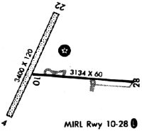
Runway Summary
| Runways: | 04/22 10/28 |
| Longest Runway: | 04/22 is 3350 ft (1021 m) long |
| Runways with an Instrument Approach: |
6B9 Airport Runway Details
| Runway 04/22 | 3350 ft x 130 ft (1021 m x 40 m) | |
| Runway Length Source: | FAA-EST as of 08/03/2006 | |
| Surface: | Turf - Fair condition - No special surface treatment | |
Runway 04 |
Runway 22 |
|
Elevation: |
1039.0 | 1012.0 |
Latitude: |
42-54-37.2420N | 42-55-07.2410N |
Longitude: |
076-26-44.7690W | 076-26-25.7680W |
|
Runway True Alignment: |
025 | 205 |
Glide Path Angle: |
0.0 degrees | 0.0 degrees |
Object at End: |
TREES | FENCE |
Object Height: |
37 | 44 |
Distance from End: |
56 | 153 |
Object Centerline Offset: |
80 ft. left of centerline | 99 ft. left of centerline |
| Runway 10/28 | 3134 ft x 58 ft (955 m x 18 m) | |
| Runway Length Source: | OWNER as of 08/03/2006 | |
| Surface: | Turf - Fair condition - No special surface treatment | |
| Runway Edge Lights: | Non-standard lighting system Intensity | |
Runway Weight Bearing Capacity (in thousands of pounds) |
||
| Single Wheel Landing Gear: | 9.0 | |
Runway 10 |
Runway 28 |
|
Elevation: |
1006.0 | 994.0 |
Latitude: |
42-54-49.5870N | 42-54-46.6760N |
Longitude: |
076-26-38.6100W | 076-25-56.6810W |
|
Runway True Alignment: |
095 | 275 |
Glide Path Angle: |
0.0 degrees | 0.0 degrees |
Traffic Pattern: |
Left | Left |
Runway Markings Type: |
Basic | Basic |
Runway Markings Condition: |
Good | Good |
Object at End: |
TREES | TREES |
Object Height: |
59 | 51 |
Distance from End: |
440 | 265 |
Object Centerline Offset: |
80 ft. left of centerline | 99 ft. left of centerline |
REIL: |
Yes | Yes |
Touchdown Lights: |
No | No |
Centerline Lights: |
No | No |
Threshold Elevation: |
999.0 | |
Displaced Threshold: |
243 | |
Threshold Latitude: |
42-54-49.3500N | |
Threshold Longitude: |
076-26-35.3500W |
Services
Airframe Repair: |
Minor |
Powerplant Repair: |
Minor |
Bottled Oxygen: |
None |
Bulk Oxygen: |
None |
Fuel Available: |
100LL |
Landing Fees: |
No |
Parking: |
Hangars and tiedowns available |
Maps & Diagrams
6B9 Sectional
Flight Planning
at skyvector.com
at skyvector.com