Location
Latitude: |
42-35-33.5100N (42.592642) |
Longitude: |
076-12-53.5780W (-76.214883) |
Elevation: |
1197.3 feet MSL (365 m MSL) |
Magnetic Variation: |
11.9 W (as of April 2024 from WMM2020 model) |
Time Zone: |
UTC -5.0 (Standard Time) UTC -4.0 (Daylight Savings Time) |
From City: |
02 N.M. SW of Cortland, New York |
Found On: |
New York Chart |
FAA Region: |
AEA |
Contacts
Manager: |
Publicly owned: |
| DAN MCLAUGHLIN 60 CENTRAL AVE. CORTLAND, NY 13045 607-745-5872 |
CORTLAND COUNTY 60 CENTRAL AVE. CORTLAND, NY 13045 607-745-9377 |
Operations
Airport Status: |
Operational |
Facility Use: |
Public |
Type: |
Airport |
Activation Date: |
02/1940 |
Control tower: |
No |
Attendance (Months/Days/Hours): |
Months/Days/Hours ALL/MON-FRI/0700-1530 |
Boundary ARTCC: |
ZNY (New York) |
Responsible ARTCC: |
ZBW (Boston) |
Lighting Schedule: |
SEE RMK |
Segmented Circle Indicator: |
Yes |
Traffic Pattern Altitude (MSL): |
2197 feet (670 m) |
NOTAMs Facility: |
N03 |
NOTAM-D Service: |
Yes |
International Airport of Entry: |
No |
Customs Landing Rights: |
No |
Military Landing Rights: |
Yes |
Civil/Military Joint Use: |
No |
Based Aircraft
| Single Engine: | 35 |
| Multi Engine: | 1 |
| Jet Engine: | 1 |
| GA Helicopters: | 1 |
Annual Operations (as of 09/15/2021)
| Total Operations: | 16989 | |
| GA Local: | 11213 | 66.0% |
| GA Itinerant: | 5776 | 34.0% |
Communications
| CTAF: | 122.800 |
| Unicom: | 122.800 |
| Approach: | ELMIRA 118.6 ;S-SE 118.6 ;S-SE 118.6 ;S-SE 118.6 ;S-SE 118.6 ;S-SE 118.6 ;S-SE NEW YORK ARTCC |
| Departure: | ELMIRA 118.6 ;S-SE 118.6 ;S-SE 118.6 ;S-SE 118.6 ;S-SE 118.6 ;S-SE 118.6 ;S-SE NEW YORK ARTCC |
| AWOS-3: | 132.225 (607-753-9784) |
- APCH SVC PRVDD BY NEW YORK ARTCC ON FREQS 133.35/372.0 (SAYRE RCAG) WHEN ELMIRA APCH CTL AND BINGHAMTON APCH CTL CLSD.
- APPROACHES FROM THE NORTH USE SYRACUSE APCH 126.125/269.125.APPROACHES FROM THE SOUTH-SOUTH EAST USE BINGHAMTON APCH 118.6/257.625.APPROACHES FROM THE WEST USE ELMIRA APCH 124.3/257.8.
Fixed Based Operators (FBOs) & Fuel
(Click on a business for detail)
Please help us keep this information up to date. This is a FREE SERVICE just like everything else on Airport Guide! If you see that a business needs to be added, modified, or deleted please fill out our Update Form.
To add, modify, or delete a business click here.
Please help us keep this information up to date. This is a FREE SERVICE just like everything else on Airport Guide! If you see that a business needs to be added, modified, or deleted please fill out our Update Form.
Area Code: 607 |
| Business Name | Frequency | Phone | Fuel Grade |
|---|---|---|---|
| Cortland County Chase
Update FBO info |
Unicom 122.8 | 753-0250 | 100LL, Mogas |
| Seven Valley Aviation
Update FBO info |
Unicom 122.8 | 758-9778 | 100LL, Jet A |
Flight Service Stations
| Primary | Alternate | |
| FSS on Field: | N | |
| FSS Name (ID): | Buffalo(BUF) | |
| Frequency: | ||
| Toll Free Phone: | 1-800-WX-BRIEF |
Instrument Procedures / Charts
FAA Terminal Procedures valid from 0901Z 03/21/24 to 0901Z 04/18/24.
There are various types of charts available for an airport. They are listed in the Page Type column. Here is a legend for those types:
APD - Airport Diagram
DP - Departure Procedure Charts
HOT - Hot Spots
IAP - Instrument Approach Procedure Charts
MIN - Minimums
STAR - Standard Terminal Arrival Charts
| Page Type | Page Name | Volume | Action Since Last Cycle |
|---|---|---|---|
| IAP | RNAV (GPS) RWY 06 | NE-2 | |
| IAP | RNAV (GPS) RWY 24 | NE-2 | |
| IAP | VOR-A | NE-2 | |
| MIN | ALTERNATE MINIMUMS | NE-2 | |
| MIN | TAKEOFF MINIMUMS | NE-2 |
Terminal Procedures are only available for airports in several countries with more being added all the time. If you are looking for a specific country's charts, please send an email to support(at)airportguide.com stating the country name. This will be used to prioritize the implementation.
Navigation Aids (Navaids) near CTX
| Dist (NM) | ID | Morse Code | Name | Type | Freq | True Hdg | Mag Hdg |
|---|---|---|---|---|---|---|---|
| 11.9 | IT | . . _ | Vrnah | NDB | 266 | 214 | 226 |
| 12.3 | ITH | . . _ . . . . | Ithaca | DME | 111.8 | 241 | 253 |
| 20.8 | GGT | _ _ . _ _ . _ | Georgetown | TACAN | 117.80 | 55 | 67 |
| 26.3 | CFB | _ . _ . . . _ . _ . . . | Binghamton | VOR-DME | 112.20 | 172 | 184 |
| 32.3 | ALP | . _ . _ . . . _ _ . | Alpine | NDB | 245 | 229 | 241 |
| 32.6 | BG | _ . . . _ _ . | Smite | NDB | 332 | 153 | 165 |
| 34.1 | SYR | . . . _ . _ _ . _ . | Syracuse | VORTAC | 117.00 | 0 | 12 |
| 37.3 | PYA | . _ _ . _ . _ _ . _ | Penn Yan | NDB | 260 | 275 | 287 |
| 41.9 | FZ | . . _ . _ _ . . | Falln | NDB | 220 | 354 | 366 |
| 43.8 | RKA | . _ . _ . _ . _ | Rockdale | VOR-DME | 112.60 | 99 | 111 |
| 46.7 | ULW | . . _ . _ . . . _ _ | Elmira | VOR-DME | 109.65 | 230 | 242 |
| 51.0 | HNK | . . . . _ . _ . _ | Hancock | VOR-DME | 116.80 | 128 | 140 |
| 53.1 | UCA | . . _ _ . _ . . _ | Utica | TACAN | 111.20 | 60 | 72 |
| 54.3 | OZ | _ _ _ _ _ . . | Kring | NDB | 279 | 90 | 102 |
| 61.0 | DNY | _ . . _ . _ . _ _ | Delancey | VOR-DME | 112.10 | 113 | 125 |
| 68.5 | GEE | _ _ . . . | Geneseo | VOR-DME | 108.20 | 282 | 294 |
| 71.5 | ROC | . _ . _ _ _ _ . _ . | Rochester | VOR-DME | 110.00 | 296 | 308 |
| 72.9 | AVN | . _ . . . _ _ . | Avon | NDB | 344 | 290 | 302 |
| 74.5 | LHY | . _ . . . . . . _ . _ _ | Lake Henry | VORTAC | 110.80 | 153 | 165 |
| 76.0 | SFK | . . . . . _ . _ . _ | Stonyfork | VOR-DME | 108.60 | 225 | 236 |
Nearby Airports with Fuel
Notices to Airmen (NOTAMS)
Remarks
| A110-2 | SNOW REMOVAL DRG DAY ONLY. |
| A110-4 | HVY CONCENTRATION OF GEESE AND GULLS ON AND INVOF ARPT DRG SPRING/FALL. |
| A110-5 | FOR CD CTC SYRACUSE APCH AT 315-455-6218. |
| A17 | UNATNDD HOLIDAYS, OTR HRS CALL ARPT MGR. |
| A70-FUEL-10 | 0LL SELF SVC AVBL 24 HRS WITH CREDIT CARD. |
| A70-FUEL-A+ | SELF SVC AVBL 24 HRS WITH CREDIT CARD. |
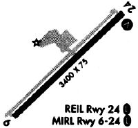
| A81-APT | ACTVT REIL RWY 24; PAPI RWY 06 & 24; MIRL RWY 06/24; TWY LGTS - CTAF. |
| E111 | FILED FOR RCRD PURPOSES ONLY. |
Runways
Runway Summary
| Runways: | 06/24 |
| Longest Runway: | 06/24 is 3401 ft (1037 m) long |
| Runways with an Instrument Approach: |
CTX Airport Runway Details
| Runway 06/24 | 3401 ft x 75 ft (1037 m x 23 m) | |
| Runway Length Source: | 3RD PARTY SURVEY as of 09/23/2021 | |
| Surface: | Asphalt - Good condition - Saw-cut or plastic grooved | |
| Runway Edge Lights: | Medium Intensity | |
Runway Weight Bearing Capacity (in thousands of pounds) |
||
| Single Wheel Landing Gear: | 12.0 | |
Runway 06 |
Runway 24 |
|
Elevation: |
1197.3 | 1163.9 |
Latitude: |
42-35-21.9107N | 42-35-45.1089N |
Longitude: |
076-13-10.0176W | 076-12-37.1365W |
|
Runway True Alignment: |
046 | 226 |
Glide Path Angle: |
4.0 degrees | 4.0 degrees |
Traffic Pattern: |
Left | Left |
Runway Markings Type: |
Nonprecision Instrument | Nonprecision Instrument |
Runway Markings Condition: |
Good | Good |
Object at End: |
TREES | TREES |
Object Height: |
44 | 56 |
Distance from End: |
707 | 773 |
Object Centerline Offset: |
285 ft. left of centerline | 297 ft. right of centerline |
Visual Glide Slope Indicators: |
2-Light PAPI On Left Side Of Runway | 2-Light PAPI On Left Side Of Runway |
REIL: |
No | Yes |
Touchdown Lights: |
No | No |
Centerline Lights: |
No | No |
Threshold Crossing Height: |
40 | 45 |
Services
Airframe Repair: |
None |
Powerplant Repair: |
None |
Bottled Oxygen: |
None |
Bulk Oxygen: |
None |
Fuel Available: |
100LL, Jet A |
Landing Fees: |
No |
Parking: |
Hangars and tiedowns available |
Maps & Diagrams
CTX Sectional
Flight Planning
at skyvector.com
at skyvector.com