Location
Latitude: |
42-09-35.4770N (42.159855) |
Longitude: |
076-53-30.2920W (-76.891748) |
Elevation: |
955.1 feet MSL (291 m MSL) |
Magnetic Variation: |
11.4 W (as of April 2024 from WMM2020 model) |
Time Zone: |
UTC -5.0 (Standard Time) UTC -4.0 (Daylight Savings Time) |
From City: |
06 N.M. NW of Elmira/Corning, New York |
Found On: |
New York Chart |
FAA Region: |
AEA |
Contacts
Manager: |
Publicly owned: |
| THOMAS FREEMAN 276 SING SING RD.,SUITE 1 HORSEHEADS, NY 14845 607-739-5621 |
COUNTY OF CHEMUNG 276 SING SING RD., SUITE 1 HORSEHEADS, NY 14845 607-739-5621 |
Operations
Airport Status: |
Operational |
Facility Use: |
Public |
Type: |
Airport |
Activation Date: |
11/1940 |
Control tower: |
Yes |
Attendance (Months/Days/Hours): |
Months/Days/Hours ALL/ALL/ALL |
Boundary ARTCC: |
ZNY (New York) |
Responsible ARTCC: |
ZNY (New York) |
Lighting Schedule: |
SEE RMK |
Segmented Circle Indicator: |
No |
Traffic Pattern Altitude (MSL): |
1955 feet (596 m) |
NOTAMs Facility: |
ELM |
NOTAM-D Service: |
Yes |
International Airport of Entry: |
No |
Customs Landing Rights: |
Yes |
Military Landing Rights: |
Yes |
Civil/Military Joint Use: |
No |
Aircraft Rescue and Firefighting: |
Class I ARFF Index: B Air Carrier Service: Scheduled Certification Date: 05/1973 |
Based Aircraft
| Single Engine: | 21 |
| Multi Engine: | 3 |
| Jet Engine: | 12 |
| GA Helicopters: | 1 |
Annual Operations (as of 04/18/2023)
| Total Operations: | 11516 | |
| Commercial: | 1982 | 17.2% |
| Air Taxi: | 2305 | 20.0% |
| GA Local: | 1898 | 16.5% |
| GA Itinerant: | 5120 | 44.5% |
| Military Aircraft: | 211 | 1.8% |
Communications
| CTAF: | 121.100 |
| Unicom: | 122.950 |
| Tower: | ELMIRA 121.1 257.8 Hrs: 0600-0000 |
| Clearance Del.: | 121.9 |
| Ground: | 121.9 |
| Approach: | ELMIRA 128.425 257.8 Hrs: 0600-0000 NEW YORK ARTCC 118.15 Hrs: 0000-0600 |
| Departure: | ELMIRA 128.425 257.8 Hrs: 0600-0000 NEW YORK ARTCC 118.15 Hrs: 0000-0600 |
| ATIS: | 125.475 Hrs: 24 |
| ASOS: | (607-796-0065) |
| EMERG: | 121.5 |
| TRSA: | 257.8 |
| TRSA: | 128.425 |
| EMERG: | 243.0 |
- APCH/DEP SVC PRVDD BY NEW YORK ARTCC ON FREQS 133.35/372.0 (SAYRE RCAG) WHEN ELMIRA APCH CTL CLSD.
- FOR CLNC DEL WHEN ATCT CLSD CTC BUFFALO RADIO ON 122.2
Fixed Based Operators (FBOs) & Fuel
(Click on a business for detail)
Please help us keep this information up to date. This is a FREE SERVICE just like everything else on Airport Guide! If you see that a business needs to be added, modified, or deleted please fill out our Update Form.
To add, modify, or delete a business click here.
Please help us keep this information up to date. This is a FREE SERVICE just like everything else on Airport Guide! If you see that a business needs to be added, modified, or deleted please fill out our Update Form.
Area Code: 607 |
| Business Name | Frequency | Phone | Fuel Grade |
|---|---|---|---|
| Elmira-Corning Air Service
Update FBO info |
Unicom 122.95 | 739-3597 | 100LL, Jet A |
Flight Service Stations
| Primary | Alternate | |
| FSS on Field: | ||
| FSS Name (ID): | Buffalo(BUF) | |
| Frequency: | ||
| Toll Free Phone: | 1-800-WX-BRIEF |
Instrument Procedures / Charts
FAA Terminal Procedures valid from 0901Z 03/21/24 to 0901Z 04/18/24.
There are various types of charts available for an airport. They are listed in the Page Type column. Here is a legend for those types:
APD - Airport Diagram
DP - Departure Procedure Charts
HOT - Hot Spots
IAP - Instrument Approach Procedure Charts
MIN - Minimums
STAR - Standard Terminal Arrival Charts
| Page Type | Page Name | Volume | Action Since Last Cycle |
|---|---|---|---|
| APD | AIRPORT DIAGRAM | NE-2 | |
| IAP | ILS OR LOC RWY 06 | NE-2 | |
| IAP | ILS OR LOC RWY 24 | NE-2 | |
| IAP | RNAV (GPS) RWY 06 | NE-2 | |
| IAP | RNAV (GPS) RWY 10 | NE-2 | |
| IAP | RNAV (GPS) RWY 24 | NE-2 | |
| IAP | RNAV (GPS) RWY 28 | NE-2 | |
| MIN | ALTERNATE MINIMUMS | NE-2 | |
| MIN | TAKEOFF MINIMUMS | NE-2 |
Terminal Procedures are only available for airports in several countries with more being added all the time. If you are looking for a specific country's charts, please send an email to support(at)airportguide.com stating the country name. This will be used to prioritize the implementation.
Navigation Aids (Navaids) near ELM
| Dist (NM) | ID | Morse Code | Name | Type | Freq | True Hdg | Mag Hdg |
|---|---|---|---|---|---|---|---|
| 7.1 | ULW | . . _ . _ . . . _ _ | Elmira | VOR-DME | 109.65 | 236 | 247 |
| 7.4 | ALP | . _ . _ . . . _ _ . | Alpine | NDB | 245 | 50 | 61 |
| 27.8 | ITH | . . _ . . . . | Ithaca | DME | 111.8 | 43 | 55 |
| 28.3 | IT | . . _ | Vrnah | NDB | 266 | 54 | 66 |
| 29.9 | PYA | . _ _ . _ . _ _ . _ | Penn Yan | NDB | 260 | 345 | 356 |
| 33.6 | CFB | _ . _ . . . _ . _ . . . | Binghamton | VOR-DME | 112.20 | 89 | 101 |
| 36.5 | SFK | . . . . . _ . _ . _ | Stonyfork | VOR-DME | 108.60 | 220 | 231 |
| 44.6 | BG | _ . . . _ _ . | Smite | NDB | 332 | 93 | 105 |
| 49.5 | ELZ | . . _ . . _ _ . . | Wellsville | DME | 115.85 | 265 | 276 |
| 49.6 | FQM | . . _ . _ _ . _ _ _ | Williamsport | VOR-DME | 114.40 | 173 | 184 |
| 53.6 | PIX | . _ _ . . . _ . . _ | Picture Rocks | NDB | 344 | 171 | 182 |
| 55.0 | GEE | _ _ . . . | Geneseo | VOR-DME | 108.20 | 317 | 328 |
| 60.4 | GGT | _ _ . _ _ . _ | Georgetown | TACAN | 117.80 | 50 | 62 |
| 61.9 | SLT | . . . . _ . . _ | Slate Run | VORTAC | 113.90 | 231 | 242 |
| 64.1 | AVN | . _ . . . _ _ . | Avon | NDB | 344 | 323 | 334 |
| 64.6 | LYS | . _ . . _ . _ _ . . . | Olean | NDB | 360 | 277 | 288 |
| 67.0 | ROC | . _ . _ _ _ _ . _ . | Rochester | VOR-DME | 110.00 | 329 | 340 |
| 67.3 | SYR | . . . _ . _ _ . _ . | Syracuse | VORTAC | 117.00 | 26 | 38 |
| 68.9 | MIP | _ _ . . . _ _ . | Milton | VORTAC | 109.20 | 171 | 182 |
| 70.4 | HNK | . . . . _ . _ . _ | Hancock | VOR-DME | 116.80 | 94 | 106 |
Nearby Airports with Fuel
Notices to Airmen (NOTAMS)
Remarks
| A110-1 | ACFT WITH WINGSPANS GTR THAN 93 FEET SHOULD USE EXTREME CARE WHEN TAXIING ON TWY T ADJ TO APRONS. |
| A110-11 | RWY 10 OPNS PROHIBITED FOR ACFT WITH APCH SPEEDS GTR THAN OR EQUAL TO 121 KNOTS AND/OR WINGSPANS GTR THAN OR EQUAL TO 118 FT . |
| A110-12 | COLD TEMPERATURE AIRPORT. ALTITUDE CORRECTION REQUIRED AT OR BELOW -22C. |
| A110-13 | TWY H, J, & L LTD TO DESIGN GROUP II ACFT. |
| A110-14 | TRML RAMP IS UNCONTROLLED. DO NOT CALL FOR PUSH/POWER BACK. ADVISE GC WHEN READY TO TAXI FOR DEP. |
| A110-15 | TWY T BTN TXY L AND TWY D NONMOVEMENT AREA. |
| A110-16 | FOR CD IF UNA TO CTC ON FSS FREQ, CTC NEW YORK ARTCC AT 631-468-1425. |
| A110-2 | EXTSV GLIDER ACT ON & INVOF ARPT. |
| A110-3 | BIRDS & DEER ON & INVOF ARPT. |
| A110-4 | RWY 05/23 (SOUTHEAST OF RWY 06/24) UNMARKED SEASONAL USE TURF RWY CLSD 1 DEC THROUGH 30 APR. |
| A110-5 | FOR LAND SIDE ACCESS FM APRON WHEN FBO CLSD CTC ELM ARPT ATTENDANT AT 607-426-5621. |
| A110-6 | WINTER DE-ICING ON GLYCOL APRON ONLY. |
| A110-7 | BLIMP ACT RQRS PPR, CTC ARPT MGMT AT 607-426-5621. |
| A13 | OR 607-739-5622. |
| A24 | LNDG FEE FOR ALL NON BASED ACFT. |
| A26 | ARFF INDEX 'C' EQUIPMENT COVERAGE IS AVBL UPON REQUEST CTC ARPT MANAGEMENT AT 607-426-5621. |
| A42-05 | RWY 05/23 MKD WITH ASPH 'L' CORNER MARKERS. |
| A43-24 | PAPI UNUSBL BYD 9 DEGS RIGHT OF CNTRLN. |
| A81-APT | WHEN ATCT CLSD ACTVT MALSR RWY 06 & 24; HIRL RWY 06/24; MIRL RWY 10/28; TWY LGTS - CTAF. |
| E111 | EXISTED PRIOR TO 1959. |
| E147 | TPA: 1545 FT AGL RECIPROCATING ENG, 2045 FT AGL TURBOPROP/JET. |
| E60-06 | ENGINEERED MATERIALS ARRESTING SYSTEM (EMAS) 259 FT IN LENGTH BY 170 FT IN WIDTH LCTD AT DER 06. |
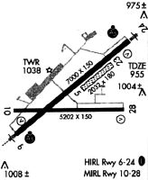
Runways
Runway Summary
| Runways: | 05/23 06/24 10/28 |
| Longest Runway: | 06/24 is 8001 ft (2439 m) long |
| Runways with an Instrument Approach: | 06, 24 |
ELM Airport Runway Details
| Runway 05/23 | 2016 ft x 150 ft (614 m x 46 m) | |
| Runway Length Source: | 3RD PARTY SURVEY as of 08/18/2021 | |
| Surface: | Turf - Good condition - No special surface treatment | |
Runway 05 |
Runway 23 |
|
Elevation: |
943.5 | 943.6 |
Latitude: |
42-09-37.2867N | 42-09-49.9963N |
Longitude: |
076-53-25.3010W | 076-53-04.6955W |
|
Runway True Alignment: |
050 | 230 |
Glide Path Angle: |
0.0 degrees | 0.0 degrees |
Declared Distances |
||
Take Off Run Avbl. (TORA): |
2017 | 2017 |
Take Off Distance Avbl. (TODA): |
2017 | 2017 |
Actual Stop Dist. Avbl. (ASDA): |
2017 | 2017 |
Landing Dist. Avbl. (LDA): |
2017 | 2017 |
| Runway 06/24 | 8001 ft x 150 ft (2439 m x 46 m) | |
| Runway Length Source: | 3RD PARTY SURVEY as of 08/18/2021 | |
| Surface: | Turf - Good condition - Saw-cut or plastic grooved | |
| Runway Pavement Class: | 50 /F/C/X/T | |
| Runway Edge Lights: | High Intensity | |
Runway Weight Bearing Capacity (in thousands of pounds) |
||
| Single Wheel Landing Gear: | 80.0 | |
| Dual Wheel Landing Gear: | 121.0 | |
| Dual Tandem Wheel Landing Gear: | 200.0 | |
Runway 06 |
Runway 24 |
|
Elevation: |
942.8 | 955.0 |
Latitude: |
42-09-13.0086N | 42-10-03.3872N |
Longitude: |
076-54-12.0599W | 076-52-50.2145W |
|
Runway True Alignment: |
050 | 230 |
ILS Type: |
ILS | ILS |
Glide Path Angle: |
3.0 degrees | 3.0 degrees |
Traffic Pattern: |
Left | Left |
Runway Markings Type: |
Precision Instrument | Precision Instrument |
Runway Markings Condition: |
Good | Good |
Arresting Device: |
EMAS | |
Object at End: |
TREE | TREE |
Object Height: |
790 | 382 |
Distance from End: |
27250 | 12329 |
Visual Glide Slope Indicators: |
4-Box VASI On Left Side Of Runway | 4-Light PAPI On Left Side Of Runway |
Runway Visual Range (RVR): |
Touchdown, Midfield, Rollout | Touchdown, Midfield, Rollout |
Approach Light System: |
1,400 Foot Medium Intensity Approach Lighting System With Runway Alignment Indicator Lights | 1,400 Foot Medium Intensity Approach Lighting System With Runway Alignment Indicator Lights |
REIL: |
Yes | Yes |
Centerline Lights: |
Yes | Yes |
Threshold Crossing Height: |
51 | 52 |
Threshold Elevation: |
939.6 | 954.8 |
Displaced Threshold: |
600 | 202 |
Threshold Latitude: |
42-09-16.7913N | 42-10-02.1284N |
Threshold Longitude: |
076-54-05.9162W | 076-52-52.2604W |
Declared Distances |
||
Take Off Run Avbl. (TORA): |
8001 | 8001 |
Take Off Distance Avbl. (TODA): |
8001 | 8001 |
Actual Stop Dist. Avbl. (ASDA): |
8001 | 8001 |
Landing Dist. Avbl. (LDA): |
7401 | 7799 |
| Runway 10/28 | 5404 ft x 150 ft (1647 m x 46 m) | |
| Runway Length Source: | 3RD PARTY SURVEY as of 08/18/2021 | |
| Surface: | Turf - Good condition - Saw-cut or plastic grooved | |
| Runway Pavement Class: | 17 /F/C/X/T | |
| Runway Edge Lights: | Medium Intensity | |
Runway Weight Bearing Capacity (in thousands of pounds) |
||
| Single Wheel Landing Gear: | 57.0 | |
| Dual Wheel Landing Gear: | 90.0 | |
| Dual Tandem Wheel Landing Gear: | 150.0 | |
Runway 10 |
Runway 28 |
|
Elevation: |
934.3 | 944.4 |
Latitude: |
42-09-28.0636N | 42-09-28.7335N |
Longitude: |
076-54-10.6086W | 076-52-58.8657W |
|
Runway True Alignment: |
089 | 269 |
Glide Path Angle: |
0.0 degrees | 3.0 degrees |
Traffic Pattern: |
Left | Left |
Runway Markings Type: |
Nonprecision Instrument | Nonprecision Instrument |
Runway Markings Condition: |
Good | Good |
Object at End: |
TREES | POLE |
Object Height: |
632 | 54 |
Distance from End: |
8761 | 1351 |
Visual Glide Slope Indicators: |
4-Light PAPI On Left Side Of Runway | |
Threshold Crossing Height: |
40 | |
Threshold Elevation: |
943.7 | |
Displaced Threshold: |
402 | |
Threshold Latitude: |
42-09-28.6860N | |
Threshold Longitude: |
076-53-04.2005W | |
Declared Distances |
||
Take Off Run Avbl. (TORA): |
5404 | 5404 |
Take Off Distance Avbl. (TODA): |
5404 | 5404 |
Actual Stop Dist. Avbl. (ASDA): |
5004 | 5404 |
Landing Dist. Avbl. (LDA): |
5004 | 5002 |
Services
Airframe Repair: |
Major |
Powerplant Repair: |
Major |
Bottled Oxygen: |
None |
Bulk Oxygen: |
None |
Fuel Available: |
100LL, Jet A |
Landing Fees: |
No |
Parking: |
Hangars and tiedowns available |
Maps & Diagrams
ELM Sectional
Flight Planning
at skyvector.com
at skyvector.com