Location
Latitude: |
41-42-05.9000N (41.701639) |
Longitude: |
074-47-42.1000W (-74.795028) |
Elevation: |
1403.0 feet MSL (428 m MSL) |
Magnetic Variation: |
12.4 W (as of April 2024 from WMM2020 model) |
Time Zone: |
UTC -5.0 (Standard Time) UTC -4.0 (Daylight Savings Time) |
From City: |
06 N.M. NW of Monticello, New York |
Found On: |
New York Chart |
FAA Region: |
AEA |
Contacts
Manager: |
Publicly owned: |
| JULIAN MOTOLA 100 NORTH ST MONTICELLO, NY 12701 845-807-0184 |
SULLIVAN COUNTY DPW 100 NORTH ST MONTICELLO, NY 12701 (845) 807-0326 |
Operations
Airport Status: |
Operational |
Facility Use: |
Public |
Type: |
Airport |
Control tower: |
No |
Attendance (Months/Days/Hours): |
Months/Days/Hours ALL/ALL/0630-1700 |
Boundary ARTCC: |
ZNY (New York) |
Responsible ARTCC: |
ZNY (New York) |
Lighting Schedule: |
SEE RMK |
Segmented Circle Indicator: |
No |
Traffic Pattern Altitude (MSL): |
2403 feet (732 m) |
NOTAMs Facility: |
MSV |
NOTAM-D Service: |
Yes |
International Airport of Entry: |
No |
Customs Landing Rights: |
No |
Military Landing Rights: |
Yes |
Civil/Military Joint Use: |
No |
Aircraft Rescue and Firefighting: |
Class IV ARFF Index: A Air Carrier Service: Not Scheduled Certification Date: 12/1974 |
Based Aircraft
| Single Engine: | 27 |
| Multi Engine: | 3 |
| GA Helicopters: | 1 |
Annual Operations (as of 09/30/2022)
| Total Operations: | 14670 | |
| Air Taxi: | 498 | 3.4% |
| GA Local: | 624 | 4.3% |
| GA Itinerant: | 13548 | 92.4% |
Communications
| CTAF: | 122.800 |
| Unicom: | 122.800 |
| Clearance Del.: | 121.6 121.6 121.6 |
| Approach: | NEW YORK |
| Departure: | NEW YORK |
| AWOS-3PT: | 124.725 (845-583-5056) |
Fixed Based Operators (FBOs) & Fuel
(Click on a business for detail)
Please help us keep this information up to date. This is a FREE SERVICE just like everything else on Airport Guide! If you see that a business needs to be added, modified, or deleted please fill out our Update Form.
To add, modify, or delete a business click here.
Please help us keep this information up to date. This is a FREE SERVICE just like everything else on Airport Guide! If you see that a business needs to be added, modified, or deleted please fill out our Update Form.
Area Code: 845 |
| Business Name | Frequency | Phone | Fuel Grade |
|---|---|---|---|
| Woodstock Aircraft Services
Update FBO info |
Unicom 122.8 | 583-5830 | 100LL, Jet A |

|
 Air BP |
100LL - 2.60 USD per gallon on 9/23/01 |
Pumps $0.05/gal discount for cash |
|
|
Air BP |
Jet A - 2.55 USD per gallon on 9/23/01 |
Pumps $0.05/gal discount for cash |
Flight Service Stations
| Primary | Alternate | |
| FSS on Field: | N | |
| FSS Name (ID): | New York(ISP) | |
| Frequency: | ||
| Toll Free Phone: | 1-800-WX-BRIEF |
Instrument Procedures / Charts
FAA Terminal Procedures valid from 0901Z 03/21/24 to 0901Z 04/18/24.
There are various types of charts available for an airport. They are listed in the Page Type column. Here is a legend for those types:
APD - Airport Diagram
DP - Departure Procedure Charts
HOT - Hot Spots
IAP - Instrument Approach Procedure Charts
MIN - Minimums
STAR - Standard Terminal Arrival Charts
| Page Type | Page Name | Volume | Action Since Last Cycle |
|---|---|---|---|
| IAP | ILS OR LOC RWY 15 | NE-2 | |
| IAP | RNAV (GPS) RWY 15 | NE-2 | |
| IAP | RNAV (GPS) RWY 33 | NE-2 | |
| MIN | ALTERNATE MINIMUMS | NE-2 | |
| MIN | TAKEOFF MINIMUMS | NE-2 |
Terminal Procedures are only available for airports in several countries with more being added all the time. If you are looking for a specific country's charts, please send an email to support(at)airportguide.com stating the country name. This will be used to prioritize the implementation.
Navigation Aids (Navaids) near MSV
| Dist (NM) | ID | Morse Code | Name | Type | Freq | True Hdg | Mag Hdg |
|---|---|---|---|---|---|---|---|
| 4.9 | MS | _ _ . . . | Monga | NDB | 359 | 323 | 335 |
| 19.8 | HUO | . . . . . . _ _ _ _ | Huguenot | VOR-DME | 116.10 | 152 | 164 |
| 28.5 | SW | . . . . _ _ | Neely | NDB | 335 | 116 | 129 |
| 29.5 | DNY | _ . . _ . _ . _ _ | Delancey | VOR-DME | 112.10 | 345 | 357 |
| 31.8 | HNK | . . . . _ . _ . _ | Hancock | VOR-DME | 116.80 | 313 | 325 |
| 33.7 | LHY | . _ . . . . . . _ . _ _ | Lake Henry | VORTAC | 110.80 | 246 | 258 |
| 35.2 | SKU | . . . _ . _ . . _ | Stanwyck | FAN MARKER | 106 | 119 | |
| 35.2 | SKU | . . . _ . _ . . _ | Stanwyck | NDB | 261 | 106 | 119 |
| 38.0 | PO | . _ _ . _ _ _ | Meier | NDB | 403 | 101 | 114 |
| 39.8 | SAX | . . . . _ _ . . _ | Sparta | VORTAC | 115.70 | 163 | 175 |
| 42.5 | STW | . . . _ . _ _ | Stillwater | VOR-DME | 109.60 | 184 | 196 |
| 43.6 | IGN | . . _ _ . _ . | Kingston | VOR-DME | 117.60 | 92 | 105 |
| 47.7 | LVZ | . _ . . . . . _ _ _ . . | Wilkes-Barre | VORTAC | 111.60 | 237 | 249 |
| 50.0 | RKA | . _ . _ . _ . _ | Rockdale | VOR-DME | 112.60 | 336 | 348 |
| 53.6 | PWL | . _ _ . . _ _ . _ . . | Pawling | VOR-DME | 114.30 | 85 | 98 |
| 53.7 | OZ | _ _ _ _ _ . . | Kring | NDB | 279 | 350 | 362 |
| 54.2 | BWZ | _ . . . . _ _ _ _ . . | Broadway | VOR-DME | 114.20 | 181 | 193 |
| 54.6 | BG | _ . . . _ _ . | Smite | NDB | 332 | 296 | 308 |
| 58.1 | PFH | . _ _ . . . _ . . . . . | Philmont | NDB | 272 | 54 | 67 |
| 60.0 | CAT | _ . _ . . _ _ | Chatham | NDB | 254 | 163 | 175 |
Nearby Airports with Fuel
Notices to Airmen (NOTAMS)
Remarks
| A110-1 | BIRDS/WATERFOWL, COYOTE & DEER ON & INVOF ARPT. |
| A110-2 | FOR CD CTC NEW YORK APCH AT 516-683-2448 OR 121.6 |
| A24 | LANDING FEE FOR ACFT OVER 8000 LBS & ALL COML ACFT REGARDLESS OF WEIGHT. |
| A26 | PPR 24 HRS FOR ACR OPS WITH MORE THAN 30 PAX SEATS; CALL AMGR 845-807-0325 OR 845-665-1714. |
| A33-15/33 | RWY 15 LONGITUDINAL CRACKING WITH WEEDS IN CRACKS. |
| A58-15 | 8 FT GROUND AER 320 FT LEFT. |
| A70-FUEL-A | JET A FUEL AVBL; 0800-1700 CALL 845-807-0325. AFTR HRS ADVN NOTICE REQ. |
| A70-FUEL-10 | 0LL SELF SVC 100LL FUEL AVBL 24 HRS DLY. |
| A81-APT | ACTVT REIL RWY 15 & 33; HIRL RWY 15/33; TWY LGTS - CTAF. PAPI RWY 15 & 33 OPR CONSLY. |
Runways
Runway Summary
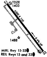
| Runways: | 15/33 |
| Longest Runway: | 15/33 is 6298 ft (1920 m) long |
| Runways with an Instrument Approach: | 15 |
MSV Airport Runway Details
| Runway 15/33 | 6298 ft x 150 ft (1920 m x 46 m) | |
| Runway Length Source: | 3RD PARTY SURVEY as of 11/12/2021 | |
| Surface: | Asphalt - Excellent condition - Saw-cut or plastic grooved | |
| Runway Pavement Class: | 37 /F/C/X/T | |
| Runway Edge Lights: | High Intensity | |
Runway Weight Bearing Capacity (in thousands of pounds) |
||
| Single Wheel Landing Gear: | 95.0 | |
| Dual Wheel Landing Gear: | 131.0 | |
| Dual Tandem Wheel Landing Gear: | 223.0 | |
Runway 15 |
Runway 33 |
|
Elevation: |
1402.8 | 1380.1 |
Latitude: |
41-42-30.7513N | 41-41-41.1055N |
Longitude: |
074-48-07.0780W | 074-47-17.0469W |
|
Runway True Alignment: |
143 | 323 |
ILS Type: |
ILS | |
Glide Path Angle: |
3.0 degrees | 3.0 degrees |
Traffic Pattern: |
Left | Left |
Runway Markings Type: |
Precision Instrument | Nonprecision Instrument |
Runway Markings Condition: |
Good | Good |
Object at End: |
TREES | TREES |
Object Height: |
62 | 19 |
Distance from End: |
2050 | 520 |
Object Centerline Offset: |
750 ft. left of centerline | 500 ft. left of centerline |
Visual Glide Slope Indicators: |
4-Light PAPI On Left Side Of Runway | 4-Light PAPI On Left Side Of Runway |
REIL: |
Yes | Yes |
Threshold Crossing Height: |
39 | 39 |
Threshold Elevation: |
1403.0 | 1380.3 |
Displaced Threshold: |
298 | 300 |
Threshold Latitude: |
41-42-28.4001N | 41-41-43.4688N |
Threshold Longitude: |
074-48-04.7085W | 074-47-19.4276W |
Declared Distances |
||
Take Off Run Avbl. (TORA): |
6298 | 6298 |
Take Off Distance Avbl. (TODA): |
6298 | 6298 |
Actual Stop Dist. Avbl. (ASDA): |
6198 | 6098 |
Landing Dist. Avbl. (LDA): |
5900 | 5798 |
Services
Airframe Repair: |
Major |
Powerplant Repair: |
Major |
Bottled Oxygen: |
None |
Bulk Oxygen: |
None |
Fuel Available: |
100LL |
Landing Fees: |
No |
Parking: |
Hangars and tiedowns available |
Maps & Diagrams
MSV Sectional
Flight Planning
at skyvector.com
at skyvector.com