Location
Latitude: |
41-00-39.0000N (41.010833) |
Longitude: |
095-15-31.9000W (-95.258861) |
Elevation: |
1045.0 feet MSL (319 m MSL) |
Magnetic Variation: |
1.6 E (as of April 2024 from WMM2020 model) |
Time Zone: |
UTC -6.0 (Standard Time) UTC -5.0 (Daylight Savings Time) |
From City: |
02 N.M. W of Red Oak, Iowa |
Found On: |
Omaha Chart |
FAA Region: |
ACE |
Contacts
Manager: |
Publicly owned: |
| KEVIN MCGREW 1674 200TH ST RED OAK, IA 51566 712-370-1511 |
CITY OF RED OAK 601 6TH ST RED OAK, IA 51566 712-370-1511 |
Operations
Airport Status: |
Operational |
Facility Use: |
Public |
Type: |
Airport |
Activation Date: |
12/1941 |
Control tower: |
No |
Attendance (Months/Days/Hours): |
Months/Days/Hours ALL/MON-FRI/0800-1700 |
Boundary ARTCC: |
ZMP (Minneapolis) |
Responsible ARTCC: |
ZMP (Minneapolis) |
Lighting Schedule: |
SEE RMK |
Segmented Circle Indicator: |
Yes |
Traffic Pattern Altitude (MSL): |
2045 feet (623 m) |
NOTAMs Facility: |
RDK |
NOTAM-D Service: |
Yes |
International Airport of Entry: |
No |
Customs Landing Rights: |
No |
Military Landing Rights: |
Yes |
Civil/Military Joint Use: |
No |
Based Aircraft
| Single Engine: | 31 |
| Ultralights: | 6 |
Annual Operations (as of 06/07/2022)
| Total Operations: | 8250 | |
| GA Local: | 5775 | 70.0% |
| GA Itinerant: | 2475 | 30.0% |
Communications
| CTAF: | 122.800 |
| Unicom: | 122.800 |
| Approach: | OMAHA 124.5 124.5 |
| Departure: | OMAHA 124.5 124.5 |
| AWOS-3P: | 123.925 (712-623-3220) |
- APCH/DEP SVC PRVDD BY OMAHA APCH CTL (R90) 0N 124.5/263.0.
Fixed Based Operators (FBOs) & Fuel
(Click on a business for detail)
Please help us keep this information up to date. This is a FREE SERVICE just like everything else on Airport Guide! If you see that a business needs to be added, modified, or deleted please fill out our Update Form.
To add, modify, or delete a business click here.
Please help us keep this information up to date. This is a FREE SERVICE just like everything else on Airport Guide! If you see that a business needs to be added, modified, or deleted please fill out our Update Form.
Area Code: 712 |
| Business Name | Frequency | Phone | Fuel Grade |
|---|---|---|---|
| Wagner Aero Service, Inc.
Update FBO info |
Unicom 122.8 | 623-9230, 623-2642 | 100LL, Jet A |
Flight Service Stations
| Primary | Alternate | |
| FSS on Field: | N | |
| FSS Name (ID): | Fort Dodge(FOD) | |
| Frequency: | ||
| Toll Free Phone: | 1-800-WX-BRIEF |
Instrument Procedures / Charts
FAA Terminal Procedures valid from 0901Z 03/21/24 to 0901Z 04/18/24.
There are various types of charts available for an airport. They are listed in the Page Type column. Here is a legend for those types:
APD - Airport Diagram
DP - Departure Procedure Charts
HOT - Hot Spots
IAP - Instrument Approach Procedure Charts
MIN - Minimums
STAR - Standard Terminal Arrival Charts
| Page Type | Page Name | Volume | Action Since Last Cycle |
|---|---|---|---|
| IAP | RNAV (GPS) RWY 05 | NC-3 | |
| IAP | RNAV (GPS) RWY 17 | NC-3 | |
| IAP | VOR/DME-A | NC-3 | |
| MIN | ALTERNATE MINIMUMS | NC-3 | |
| MIN | TAKEOFF MINIMUMS | NC-3 |
Terminal Procedures are only available for airports in several countries with more being added all the time. If you are looking for a specific country's charts, please send an email to support(at)airportguide.com stating the country name. This will be used to prioritize the implementation.
Navigation Aids (Navaids) near KRDK
| Dist (NM) | ID | Morse Code | Name | Type | Freq | True Hdg | Mag Hdg |
|---|---|---|---|---|---|---|---|
| 0.3 | RDK | . _ . _ . . _ . _ | Red Oak | NDB | 230 | 28 | 26 |
| 16.9 | SDA | . . . _ . . . _ | Shenandoah | NDB | 411 | 203 | 201 |
| 20.2 | ICL | . . _ . _ . . _ . . | Clarinda | NDB | 353 | 148 | 146 |
| 22.7 | CRZ | _ . _ . . _ . _ _ . . | Corning | NDB | 278 | 92 | 91 |
| 23.6 | OVR | _ _ _ . . . _ . _ . | Omaha | VORTAC | 116.30 | 293 | 291 |
| 25.5 | AIO | . _ . . _ _ _ | Atlantic | NDB | 365 | 22 | 20 |
| 28.2 | EN | . _ . | Rikky | NDB | 426 | 296 | 294 |
| 29.7 | OFF | _ _ _ . . _ . . . _ . | Offutt | TACAN | 111.70 | 282 | 280 |
| 29.9 | PMV | . _ _ . _ _ . . . _ | Plattsmouth | NDB | 329 | 262 | 260 |
| 33.1 | OMA | _ _ _ _ _ . _ | Omaha | VOT | 109.00 | 301 | 299 |
| 34.3 | HNR | . . . . _ . . _ . | Harlan | NDB | 272 | 353 | 351 |
| 36.6 | AFK | . _ . . _ . _ . _ | Nebraska City | NDB | 347 | 228 | 226 |
| 38.1 | OM | _ _ _ _ _ | Gerfi | NDB | 320 | 304 | 302 |
| 40.2 | MLE | _ _ . _ . . . | Millard | NDB | 371 | 286 | 284 |
| 41.4 | UNE | . . _ _ . . | Union County | NDB | 379 | 94 | 93 |
| 43.6 | ADU | . _ _ . . . . _ | Audubon | NDB | 266 | 21 | 20 |
| 58.0 | FNB | . . _ . _ . _ . . . | Brenner | NDB | 404 | 195 | 193 |
| 58.6 | DNS | _ . . _ . . . . | Denison | NDB | 350 | 354 | 352 |
| 61.1 | TQE | _ _ _ . _ . | Tekamah | VOR | 108.40 | 317 | 315 |
| 62.1 | AHQ | . _ . . . . _ _ . _ | Wahoo | NDB | 400 | 283 | 281 |
Nearby Airports with Fuel
Notices to Airmen (NOTAMS)
Remarks
| A11 | NICK HILDRETH - CHMN - 402-658-1782 |
| A110-1 | ULTRALIGHTS ON & INVOF ARPT. |
| A110-2 | +44' P/POLES AT 1650' RY 35. |
| A110-4 | RY 23 IS CALM WIND RY. |
| A110-6 | FOR CD CTC OMAHA APCH AT 402-682-4395. |
| A17 | ON CALL WKENDS AND HOLIDAYS 712-370-1511. |
| A30-13/31 | RUNWAY IS NOT MAINTAINED NOV-APR. |
| A42-13 | 13/31 ENDS & SIDES MARKED WITH YELLOW CONES. |
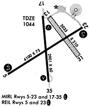
| A81-APT | ACTVT MIRL RYS 17/35 & 05/23; PAPIS RYS 05/23 & 17/35 AND REIL RYS 05/23 & 17/35- CTAF. |
Runways
Runway Summary
| Runways: | 05/23 13/31 17/35 |
| Longest Runway: | 05/23 is 5100 ft (1554 m) long |
| Runways with an Instrument Approach: |
KRDK Airport Runway Details
| Runway 05/23 | 5100 ft x 75 ft (1554 m x 23 m) | |
| Runway Length Source: | 3RD PARTY SURVEY as of 09/07/2008 | |
| Surface: | Concrete - Good condition - No special surface treatment | |
| Runway Pavement Class: | 9 /R/C/W/T | |
| Runway Edge Lights: | Medium Intensity | |
Runway Weight Bearing Capacity (in thousands of pounds) |
||
| Single Wheel Landing Gear: | 30.0 | |
| Dual Wheel Landing Gear: | 42.0 | |
Runway 05 |
Runway 23 |
|
Elevation: |
1042.1 | 1045.0 |
Latitude: |
41-00-25.3334N | 41-00-52.1138N |
Longitude: |
095-16-00.1957W | 095-15-03.8480W |
|
Runway True Alignment: |
058 | 238 |
Glide Path Angle: |
3.0 degrees | 3.0 degrees |
Runway Markings Type: |
Nonprecision Instrument | Nonprecision Instrument |
Runway Markings Condition: |
Good | Good |
Object at End: |
RR | TREES |
Object Height: |
60 | 76 |
Distance from End: |
1752 | 1796 |
Object Centerline Offset: |
0 ft. left and right of centerline | 111 ft. left of centerline |
Visual Glide Slope Indicators: |
2-Light PAPI On Left Side Of Runway | 2-Light PAPI On Left Side Of Runway |
REIL: |
Yes | Yes |
Threshold Crossing Height: |
26 | 33 |
Threshold Elevation: |
1040.5 | |
Displaced Threshold: |
1000 | |
Threshold Latitude: |
41-00-30.5825N | |
Threshold Longitude: |
095-15-49.1508W |
| Runway 13/31 | 2050 ft x 210 ft (625 m x 64 m) | |
| Runway Length Source: | 3RD PARTY SURVEY as of 09/07/2008 | |
| Surface: | Concrete - Good condition - No special surface treatment | |
Runway 13 |
Runway 31 |
|
Elevation: |
1042.4 | 1038.7 |
Latitude: |
41-00-50.0906N | 41-00-34.2271N |
Longitude: |
095-15-33.7154W | 095-15-17.0801W |
|
Runway True Alignment: |
142 | 322 |
Glide Path Angle: |
0.0 degrees | 0.0 degrees |
Traffic Pattern: |
Left | Left |
Object at End: |
ROAD | POLE |
Object Height: |
27 | 51 |
Distance from End: |
900 | 1210 |
Object Centerline Offset: |
0 ft. left and right of centerline | 111 ft. left of centerline |
| Runway 17/35 | 2901 ft x 60 ft (884 m x 18 m) | |
| Runway Length Source: | 3RD PARTY SURVEY as of 09/07/2008 | |
| Surface: | Concrete - Good condition - No special surface treatment | |
| Runway Pavement Class: | 8 /R/C/W/T | |
| Runway Edge Lights: | Medium Intensity | |
Runway Weight Bearing Capacity (in thousands of pounds) |
||
| Single Wheel Landing Gear: | 12.5 | |
Runway 17 |
Runway 35 |
|
Elevation: |
1044.8 | 1038.7 |
Latitude: |
41-00-51.4727N | 41-00-22.9466N |
Longitude: |
095-15-38.0658W | 095-15-34.3790W |
|
Runway True Alignment: |
174 | 354 |
Glide Path Angle: |
3.0 degrees | 3.0 degrees |
Traffic Pattern: |
Left | Left |
Runway Markings Type: |
Nonprecision Instrument | Nonprecision Instrument |
Runway Markings Condition: |
Good | Good |
Object at End: |
ROAD | PLINE |
Object Height: |
23 | 44 |
Distance from End: |
680 | 1124 |
Object Centerline Offset: |
0 ft. left and right of centerline | 111 ft. left of centerline |
Visual Glide Slope Indicators: |
2-Light PAPI On Left Side Of Runway | 2-Light PAPI On Left Side Of Runway |
REIL: |
Yes | Yes |
Threshold Crossing Height: |
32 | 33 |
Services
Airframe Repair: |
None |
Powerplant Repair: |
None |
Bottled Oxygen: |
None |
Bulk Oxygen: |
None |
Fuel Available: |
100LL, Jet A |
Landing Fees: |
No |
Parking: |
Hangars and tiedowns available |
Maps & Diagrams
KRDK Sectional
Flight Planning
at skyvector.com
at skyvector.com