Location
Latitude: |
43-05-11.3000N (43.086472) |
Longitude: |
124-24-28.3000W (-124.407861) |
Elevation: |
122.1 feet MSL (37 m MSL) |
Magnetic Variation: |
14.5 E (as of May 2024 from WMM2020 model) |
Time Zone: |
UTC -8.0 (Standard Time) UTC -7.0 (Daylight Savings Time) |
From City: |
02 N.M. SE of Bandon, Oregon |
Found On: |
Klamath Falls Chart |
FAA Region: |
ANM |
Contacts
Manager: |
Publicly owned: |
| STATE AIRPORTS MGR 3040 25TH ST SE SALEM, OR 97302-1125 503-378-4880 |
OREGON DEPT. OF AVIATION 3040 25TH ST SE SALEM, OR 97302-1125 503-378-4880 |
Operations
Airport Status: |
Operational |
Facility Use: |
Public |
Type: |
Airport |
Activation Date: |
01/1958 |
Control tower: |
No |
Attendance (Months/Days/Hours): |
Months/Days/Hours ALL/ALL/0700-1800 |
Boundary ARTCC: |
ZSE (Seattle) |
Responsible ARTCC: |
ZSE (Seattle) |
Lighting Schedule: |
SEE RMK |
Segmented Circle Indicator: |
Yes |
Traffic Pattern Altitude (MSL): |
1122 feet (342 m) |
NOTAMs Facility: |
MMV |
NOTAM-D Service: |
Yes |
International Airport of Entry: |
No |
Customs Landing Rights: |
No |
Military Landing Rights: |
No |
Civil/Military Joint Use: |
No |
Based Aircraft
| Single Engine: | 26 |
| Multi Engine: | 4 |
| GA Helicopters: | 1 |
Annual Operations (as of 08/25/2021)
| Total Operations: | 7100 | |
| Air Taxi: | 500 | 7.0% |
| GA Local: | 3500 | 49.3% |
| GA Itinerant: | 3000 | 42.3% |
| Military Aircraft: | 100 | 1.4% |
Communications
| CTAF: | 122.800 |
| Unicom: | 122.800 |
Fixed Based Operators (FBOs) & Fuel
(Click on a business for detail)
Please help us keep this information up to date. This is a FREE SERVICE just like everything else on Airport Guide! If you see that a business needs to be added, modified, or deleted please fill out our Update Form.
To add, modify, or delete a business click here.
Please help us keep this information up to date. This is a FREE SERVICE just like everything else on Airport Guide! If you see that a business needs to be added, modified, or deleted please fill out our Update Form.
Area Code: 503 |
| Business Name | Frequency | Phone | Fuel Grade |
|---|---|---|---|
| Frank's Flight Service
Update FBO info |
Unicom 122.8 | 347-2022 | 100LL |
Flight Service Stations
| Primary | Alternate | |
| FSS on Field: | N | |
| FSS Name (ID): | Mc Minnville(MMV) | |
| Frequency: | ||
| Toll Free Phone: | 1-800-WX-BRIEF |
Instrument Procedures / Charts
Terminal Procedures are only available for airports in several countries with more being added all the time. If you are looking for a specific country's charts, please send an email to support(at)airportguide.com stating the country name. This will be used to prioritize the implementation.
Navigation Aids (Navaids) near BDY
| Dist (NM) | ID | Morse Code | Name | Type | Freq | True Hdg | Mag Hdg |
|---|---|---|---|---|---|---|---|
| 19.0 | OT | _ _ _ _ | Emire | NDB | 378 | 12 | 357 |
| 22.3 | OTH | _ _ _ _ . . . . | North Bend | VOR-DME | 112.10 | 27 | 12 |
| 46.6 | RBG | . _ . _ . . . _ _ . | Roseburg | VOR-DME | 108.20 | 82 | 68 |
| 46.8 | RBG | . _ . _ . . . _ _ . | Roseburg | NDB | 400 | 78 | 64 |
| 75.2 | OED | _ _ _ . _ . . | Rogue Valley | VORTAC | 113.60 | 118 | 104 |
| 78.8 | CEC | _ . _ . . _ . _ . | Crescent City | VORTAC | 109.00 | 174 | 160 |
| 79.2 | MEF | _ _ . . . _ . | Medford | NDB | 356 | 121 | 107 |
| 80.6 | EUG | . . . _ _ _ . | Eugene | VORTAC | 112.90 | 39 | 24 |
| 80.8 | MFR | _ _ . . _ . . _ . | Medford | VOT | 117.20 | 122 | 108 |
| 85.0 | EU | . . . _ | Frakk | NDB | 260 | 36 | 21 |
| 90.6 | ONP | _ _ _ _ . . _ _ . | Newport | VORTAC | 117.10 | 9 | 354 |
| 97.6 | CVO | _ . _ . . . . _ _ _ _ | Corvallis | VOR-DME | 115.40 | 29 | 14 |
Nearby Airports with Fuel
Notices to Airmen (NOTAMS)
Remarks
| A110-1 | TWY MKD WITH BLUE REFLECTORS. |
| A110-2 | DEER INVOF RY & ARPT. |
| A110-3 | FOR CD CTC SEATTLE ARTCC AT 253-351-3694. |
| A110-4 | SFC CONDS NOT RPRTD. |
| A43-34 | UNUSBL BYD 7 DEGS RIGHT OF CNTRLN |
| A81-APT | ACTVT MIRL RY 16/34; REIL RYS 16 & 34 AND PAPI RYS 16/34 - CTAF. |
| E111 | ESTABD PRIOR TO 1959. |
Runways
Runway Summary
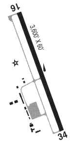
| Runways: | 16/34 |
| Longest Runway: | 16/34 is 3601 ft (1098 m) long |
| Runways with an Instrument Approach: |
BDY Airport Runway Details
| Runway 16/34 | 3601 ft x 60 ft (1098 m x 18 m) | |
| Runway Length Source: | 3RD PARTY SURVEY as of 01/31/2006 | |
| Surface: | Asphalt - Good condition - No special surface treatment | |
| Runway Edge Lights: | Medium Intensity | |
Runway Weight Bearing Capacity (in thousands of pounds) |
||
| Single Wheel Landing Gear: | 12.0 | |
Runway 16 |
Runway 34 |
|
Elevation: |
105.1 | 122.1 |
Latitude: |
43-05-29.0247N | 43-04-53.4859N |
Longitude: |
124-24-29.0884W | 124-24-27.5259W |
|
Runway True Alignment: |
178 | 358 |
Glide Path Angle: |
4.0 degrees | 4.0 degrees |
Traffic Pattern: |
Left | Left |
Runway Markings Type: |
Nonprecision Instrument | Nonprecision Instrument |
Runway Markings Condition: |
Good | Good |
Object at End: |
TREES | TREES |
Object Height: |
135 | 75 |
Distance from End: |
2175 | 1500 |
Object Centerline Offset: |
75 ft. left of centerline | 0 ft. left and right of centerline |
Visual Glide Slope Indicators: |
4-Light PAPI On Left Side Of Runway | 4-Light PAPI On Left Side Of Runway |
REIL: |
Yes | Yes |
Threshold Crossing Height: |
55 | 42 |
Services
Airframe Repair: |
Major |
Powerplant Repair: |
Major |
Bottled Oxygen: |
High Pressure |
Bulk Oxygen: |
High Pressure / Low Pressure |
Fuel Available: |
100LL, Jet A |
Landing Fees: |
No |
Parking: |
Hangars and tiedowns available |
Maps & Diagrams
BDY Sectional
Flight Planning
at skyvector.com
at skyvector.com