Location
Latitude: |
38-56-28.8670N (38.941352) |
Longitude: |
076-46-20.5790W (-76.772383) |
Elevation: |
168.1 feet MSL (51 m MSL) |
Magnetic Variation: |
10.9 W (as of May 2024 from WMM2020 model) |
Time Zone: |
UTC -5.0 (Standard Time) UTC -4.0 (Daylight Savings Time) |
From City: |
02 N.M. NW of Mitchellville, Maryland |
Found On: |
Washington Chart |
FAA Region: |
AEA |
Contacts
Manager: |
Privately owned: |
| MATTHEW LINDQUIST 3900 CHURCH RD MITCHELLVILLE, MD 20716 301-390-6424 |
FREEWAY AIRPORT INC. 3900 CHURCH RD BOWIE, MD 20721 301-390-6424 |
Operations
Airport Status: |
Operational |
Facility Use: |
Public |
Type: |
Airport |
Activation Date: |
06/1961 |
Control tower: |
No |
Attendance (Months/Days/Hours): |
Months/Days/Hours ALL/ALL/0800-1700 |
Boundary ARTCC: |
ZDC (Washington) |
Responsible ARTCC: |
ZDC (Washington) |
Lighting Schedule: |
SEE RMK |
Segmented Circle Indicator: |
Yes |
Traffic Pattern Altitude (MSL): |
1168 feet (356 m) |
NOTAMs Facility: |
DCA |
NOTAM-D Service: |
Yes |
International Airport of Entry: |
No |
Customs Landing Rights: |
No |
Military Landing Rights: |
No |
Civil/Military Joint Use: |
No |
Based Aircraft
| Single Engine: | 74 |
| Multi Engine: | 2 |
| Ultralights: | 1 |
Annual Operations (as of 08/29/2023)
| Total Operations: | 32115 | |
| Air Taxi: | 15 | 0.0% |
| GA Local: | 31000 | 96.5% |
| GA Itinerant: | 1000 | 3.1% |
| Military Aircraft: | 100 | 0.3% |
Communications
| CTAF: | 123.075 |
| Unicom: | 123.075 |
| Approach: | POTOMAC |
| Departure: | POTOMAC |
Fixed Based Operators (FBOs) & Fuel
(Click on a business for detail)
Please help us keep this information up to date. This is a FREE SERVICE just like everything else on Airport Guide! If you see that a business needs to be added, modified, or deleted please fill out our Update Form.
To add, modify, or delete a business click here.
Please help us keep this information up to date. This is a FREE SERVICE just like everything else on Airport Guide! If you see that a business needs to be added, modified, or deleted please fill out our Update Form.
Area Code: 301 |
| Business Name | Frequency | Phone | Fuel Grade |
|---|---|---|---|
| Freeway Airport, Inc.
Update FBO info |
Unicom 123.050 | 390-6424, 410-792-0380 | 100LL |
Flight Service Stations
| Primary | Alternate | |
| FSS on Field: | N | |
| FSS Name (ID): | Leesburg(DCA) | |
| Frequency: | ||
| Toll Free Phone: | 1-800-WX-BRIEF |
Instrument Procedures / Charts
FAA Terminal Procedures valid from 0901Z 03/21/24 to 0901Z 04/18/24.
There are various types of charts available for an airport. They are listed in the Page Type column. Here is a legend for those types:
APD - Airport Diagram
DP - Departure Procedure Charts
HOT - Hot Spots
IAP - Instrument Approach Procedure Charts
MIN - Minimums
STAR - Standard Terminal Arrival Charts
| Page Type | Page Name | Volume | Action Since Last Cycle |
|---|---|---|---|
| IAP | RNAV (GPS) RWY 18 | NE-3 | |
| IAP | RNAV (GPS) RWY 36 | NE-3 | |
| MIN | TAKEOFF MINIMUMS | NE-3 | |
| STAR | TIKEE FOUR (RNAV) | NE-3 |
Terminal Procedures are only available for airports in several countries with more being added all the time. If you are looking for a specific country's charts, please send an email to support(at)airportguide.com stating the country name. This will be used to prioritize the implementation.
Navigation Aids (Navaids) near W00
| Dist (NM) | ID | Morse Code | Name | Type | Freq | True Hdg | Mag Hdg |
|---|---|---|---|---|---|---|---|
| 8.6 | BUH | _ . . . . . _ . . . . | Anne Arundel | NDB | 260 | 3 | 14 |
| 9.2 | ADW | . _ _ . . . _ _ | Andrews | VORTAC | 113.10 | 208 | 219 |
| 9.5 | ADW | . _ _ . . . _ _ | Andrews Afb | VOT | 109.60 | 211 | 222 |
| 13.3 | DCA | _ . . _ . _ . . _ | Washington | VOR-DME | 111.00 | 248 | 259 |
| 14.2 | OTT | _ _ _ _ _ | Nottingham | VORTAC | 113.70 | 174 | 185 |
| 14.7 | BAL | _ . . . . _ . _ . . | Baltimore | VORTAC | 115.10 | 20 | 31 |
| 15.9 | DCA | _ . . _ . _ . . _ | Oxonn | NDB | 332 | 228 | 239 |
| 16.4 | GTN | _ _ . _ _ . | Georgetown | NDB | 323 | 267 | 278 |
| 20.8 | FND | . . _ . _ . _ . . | Ellicott | NDB | 371 | 359 | 370 |
| 21.8 | IUB | . . . . _ _ . . . | Institute | NDB | 404 | 18 | 29 |
| 22.9 | GAI | _ _ . . _ . . | Gaithersburg | NDB | 385 | 306 | 317 |
| 23.0 | DAA | _ . . . _ . _ | Davee | NDB | 223 | 223 | 234 |
| 32.4 | AML | . _ _ _ . _ . . | Armel | VOR-DME | 113.50 | 269 | 280 |
| 34.6 | EMI | . _ _ . . | Westminster | VORTAC | 117.90 | 343 | 354 |
| 39.8 | FDK | . . _ . _ . . _ . _ | Frederick | VOR | 109.00 | 315 | 326 |
| 42.1 | PPM | . _ _ . . _ _ . _ _ | Phillips | VOR-DME | 108.40 | 41 | 52 |
| 42.3 | CGE | _ . _ . _ _ . . | Cambridge | NDB | 355 | 124 | 135 |
| 42.9 | PXT | . _ _ . _ . . _ _ | Patuxent | VORTAC | 117.60 | 155 | 166 |
| 43.0 | NHK | _ . . . . . _ . _ | Patuxent | NDB | 400 | 156 | 167 |
| 43.1 | NHK | _ . . . . . _ . _ | Nas Patuxent River | TACAN | 110.25 | 156 | 167 |
Nearby Airports with Fuel
Notices to Airmen (NOTAMS)
Remarks
| A110-1 | TPA 1000 FT MSL (832 FT AGL) FOR ACFT LESS THAN 4000 LBS MAX GWT; TPA 1200 FT MSL (1032 FT AGL) FOR ACFT GREATER THAN 4000 LBS. |
| A110-2 | -15 FT DROP 80 FT FROM APCH TO RWY 36. |
| A110-3 | -7 FT DROP 50 FT FM APCH END RWY 18. |
| A110-5 | UNLGTD ANTENNA 135 FT AGL 600 FT NW AER 18. |
| A110-6 | FOR CD CTC POTOMAC APCH AT 866-599-3874. |
| A110-7 | TWY RUNUP AREA FOR RWY 36 CLSD. |
| A17 | UNATNDD MAJOR HOLIDAYS. |
| A57-36 | APCH RATIO 15:1 TO DSPLCD THR AT CNTRLN. |
| A58-18 | +7 FT ROAD AT 115 FT OUT, OB. |
| A70-FUEL-10 | 0LL 100LL AVBL WHEN ATNDD. |
| A81-APT | ACTVT PAPI RWYS 18 & 36; MIRL RWY 18/36 - CTAF. |
| E111 | ESTAB PRIOR TO 1959. |
Runways
Runway Summary
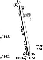
| Runways: | 18/36 |
| Longest Runway: | 18/36 is 2420 ft (738 m) long |
| Runways with an Instrument Approach: |
W00 Airport Runway Details
| Runway 18/36 | 2420 ft x 40 ft (738 m x 12 m) | |
| Runway Length Source: | FAA-EST as of 09/26/2006 | |
| Surface: | Asphalt - Fair condition - No special surface treatment | |
| Runway Edge Lights: | Medium Intensity | |
Runway 18 |
Runway 36 |
|
Elevation: |
168.1 | 151.6 |
Latitude: |
38-56-40.7200N | 38-56-17.1500N |
Longitude: |
076-46-23.1700W | 076-46-17.9800W |
|
Runway True Alignment: |
170 | 350 |
Glide Path Angle: |
6.0 degrees | 5.5 degrees |
Traffic Pattern: |
Left | Right |
Runway Markings Type: |
Nonprecision Instrument | Nonprecision Instrument |
Runway Markings Condition: |
Fair | Fair |
Object at End: |
TREES | TREES |
Object Height: |
50 | 91 |
Distance from End: |
819 | 459 |
Object Centerline Offset: |
100 ft. left of centerline | 140 ft. left of centerline |
Visual Glide Slope Indicators: |
2-Light PAPI On Right Side Of Runway | 2-Light PAPI On Left Side Of Runway |
Threshold Crossing Height: |
47 | 26 |
Threshold Elevation: |
168.1 | |
Displaced Threshold: |
230 | |
Threshold Latitude: |
38-56-19.3830N | |
Threshold Longitude: |
076-46-18.5050W |
Services
Airframe Repair: |
None |
Powerplant Repair: |
None |
Fuel Available: |
100LL, Jet A |
Landing Fees: |
No |
Parking: |
Hangars and tiedowns available |
Maps & Diagrams
W00 Sectional
Flight Planning
at skyvector.com
at skyvector.com