Location
Latitude: |
38-59-26.2000N (38.990611) |
Longitude: |
122-54-02.6000W (-122.900722) |
Elevation: |
1380.1 feet MSL (421 m MSL) |
Magnetic Variation: |
13.4 E (as of April 2024 from WMM2020 model) |
Time Zone: |
UTC -8.0 (Standard Time) UTC -7.0 (Daylight Savings Time) |
From City: |
03 N.M. S of Lakeport, California |
Found On: |
San Francisco Chart |
FAA Region: |
AWP |
Contacts
Manager: |
Publicly owned: |
| CELIA A. HOBERG 255 N FORBES ST #309 LAKEPORT, CA 95453 707-263-2341 |
LAKE COUNTY 255 N FORBES ST LAKEPORT, CA 95453 707-263-2341 |
Operations
Airport Status: |
Operational |
Facility Use: |
Public |
Type: |
Airport |
Activation Date: |
10/1941 |
Control tower: |
No |
Attendance (Months/Days/Hours): |
Months/Days/Hours Unattended |
Boundary ARTCC: |
ZOA (Oakland) |
Responsible ARTCC: |
ZOA (Oakland) |
Lighting Schedule: |
SEE RMK |
Segmented Circle Indicator: |
Yes |
Traffic Pattern Altitude (MSL): |
2380 feet (725 m) |
NOTAMs Facility: |
OAK |
NOTAM-D Service: |
Yes |
International Airport of Entry: |
No |
Customs Landing Rights: |
No |
Military Landing Rights: |
No |
Civil/Military Joint Use: |
No |
Based Aircraft
| Single Engine: | 22 |
| Gliders: | 9 |
Annual Operations (as of 12/31/2021)
| Total Operations: | 76500 | |
| GA Local: | 37000 | 48.4% |
| GA Itinerant: | 37000 | 48.4% |
| Military Aircraft: | 2500 | 3.3% |
Communications
| CTAF: | 122.800 |
| Unicom: | 122.800 |
| AWOS-3: | 118.35 (707-262-0380) |
- APCH/DEP CTL SVC PRVDD BY OAKLAND ARTCC (ZOA) ON FREQS 127.8/353.5 (UKIAH RCAG).
Fixed Based Operators (FBOs) & Fuel
(Click on a business for detail)
Please help us keep this information up to date. This is a FREE SERVICE just like everything else on Airport Guide! If you see that a business needs to be added, modified, or deleted please fill out our Update Form.
To add, modify, or delete a business click here.
Please help us keep this information up to date. This is a FREE SERVICE just like everything else on Airport Guide! If you see that a business needs to be added, modified, or deleted please fill out our Update Form.
Area Code: 707 |
| Business Name | Frequency | Phone | Fuel Grade |
|---|---|---|---|
| Air North Coast
Update FBO info |
262-1606 | ||
| Air Power
Update FBO info |
263-5376 | ||
| Lake Aero Styling & Repair
Update FBO info |
263-0412 | ||
| Lampson Field Texaco
Update FBO info |
263-6512 | 100LL | |
| Resort Aviation
Update FBO info |
263-1414 | ||
| Steve's Aircraft
Update FBO info |
262-1818 | ||
| Tom's Aircraft Enterprises
Update FBO info |
263-9330 |
Flight Service Stations
| Primary | Alternate | |
| FSS on Field: | N | |
| FSS Name (ID): | Oakland(OAK) | |
| Frequency: | ||
| Toll Free Phone: | 1-800-WX-BRIEF |
Instrument Procedures / Charts
FAA Terminal Procedures valid from 0901Z 03/21/24 to 0901Z 04/18/24.
There are various types of charts available for an airport. They are listed in the Page Type column. Here is a legend for those types:
APD - Airport Diagram
DP - Departure Procedure Charts
HOT - Hot Spots
IAP - Instrument Approach Procedure Charts
MIN - Minimums
STAR - Standard Terminal Arrival Charts
| Page Type | Page Name | Volume | Action Since Last Cycle |
|---|---|---|---|
| DP | LAKEPORT THREE (RNAV) | SW-2 | |
| IAP | RNAV (GPS)-A | SW-2 | |
| MIN | TAKEOFF MINIMUMS | SW-2 |
Terminal Procedures are only available for airports in several countries with more being added all the time. If you are looking for a specific country's charts, please send an email to support(at)airportguide.com stating the country name. This will be used to prioritize the implementation.
Navigation Aids (Navaids) near 1O2
| Dist (NM) | ID | Morse Code | Name | Type | Freq | True Hdg | Mag Hdg |
|---|---|---|---|---|---|---|---|
| 17.8 | ENI | . _ . . . | Mendocino | VORTAC | 112.30 | 282 | 269 |
| 23.3 | UK | . . _ _ . _ | Kearn | NDB | 371 | 317 | 304 |
| 29.3 | STS | . . . _ . . . | Santa Rosa | DME | 116.15 | 171 | 158 |
| 37.2 | MXW | _ _ _ . . _ . _ _ | Maxwell | VORTAC | 110.00 | 57 | 44 |
| 41.0 | ILA | . . . _ . . . _ | Williams | VORTAC | 114.40 | 82 | 69 |
| 54.6 | SGD | . . . _ _ . _ . . | Scaggs Island | VORTAC | 112.10 | 152 | 139 |
| 54.7 | PYE | . _ _ . _ . _ _ . | Point Reyes | VOR-DME | 113.70 | 178 | 165 |
| 61.1 | MY | _ _ _ . _ _ | Halow | NDB | 222 | 79 | 66 |
| 62.2 | MYV | _ _ _ . _ _ . . . _ | Marysville | VOR-DME | 110.80 | 83 | 70 |
| 63.3 | SUU | . . . . . _ . . _ | Travis | TACAN | 116.60 | 134 | 121 |
| 63.8 | SMF | . . . _ _ . . _ . | Sacramento Intl | VOT | 111.40 | 105 | 92 |
| 64.1 | TZZ | _ _ _ . . _ _ . . | Travis | VOR | 116.40 | 126 | 113 |
| 68.5 | CIC | _ . _ . . . _ . _ . | Chico | VOR-DME | 109.80 | 45 | 32 |
| 68.6 | BAB | _ . . . . _ _ . . . | Beale | TACAN | 108.60 | 82 | 69 |
| 69.5 | CCR | _ . _ . _ . _ . . _ . | Concord | VOR-DME | 117.00 | 144 | 131 |
| 69.8 | CC | _ . _ . _ . _ . | Kanan | NDB | 335 | 144 | 131 |
| 70.4 | SAU | . . . . _ . . _ | Sausalito | VOR-DME | 116.20 | 165 | 152 |
| 71.2 | SAC | . . . . _ _ . _ . | Sacramento | VORTAC | 115.20 | 117 | 104 |
| 71.9 | SAC | . . . . _ _ . _ . | Sacramento Executive | VOT | 111.40 | 113 | 100 |
| 72.6 | MCC | _ _ _ . _ . _ . _ . | Mc Clellan | VOR-DME | 109.20 | 105 | 92 |
Nearby Airports with Fuel
Notices to Airmen (NOTAMS)
Remarks
| A110-1 | FOR CD CTC OAKLAND ARTCC AT 510-745-3380. |
| A16 | PRINCIPAL CIVIL ENGINEER; OFFICE IN LAKEPORT, CA. |
| A57-28 | APCH RATIO TO DSPLCD THR 21:1. |
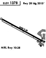
| A81-APT | ACTVT MIRL RWY 10/28 - CTAF. |
Runways
Runway Summary
| Runways: | 10/28 |
| Longest Runway: | 10/28 is 3600 ft (1097 m) long |
| Runways with an Instrument Approach: |
1O2 Airport Runway Details
| Runway 10/28 | 3600 ft x 60 ft (1097 m x 18 m) | |
| Runway Length Source: | 3RD PARTY SURVEY as of 11/21/2009 | |
| Surface: | Asphalt - Good condition - No special surface treatment | |
| Runway Edge Lights: | Medium Intensity | |
Runway Weight Bearing Capacity (in thousands of pounds) |
||
| Single Wheel Landing Gear: | 30.0 | |
Runway 10 |
Runway 28 |
|
Elevation: |
1380.1 | 1370.8 |
Latitude: |
38-59-34.8342N | 38-59-17.5234N |
Longitude: |
122-54-22.4987W | 122-53-42.6688W |
|
Runway True Alignment: |
119 | 299 |
Glide Path Angle: |
0.0 degrees | 4.0 degrees |
Traffic Pattern: |
Right | |
Runway Markings Type: |
Basic | Basic |
Runway Markings Condition: |
Good | Good |
Object at End: |
TREES | ROAD |
Object Height: |
30 | 15 |
Distance from End: |
700 | 236 |
Object Centerline Offset: |
290 ft. right of centerline | 133 ft. right of centerline |
Visual Glide Slope Indicators: |
2-Light PAPI On Left Side Of Runway | |
REIL: |
No | No |
Touchdown Lights: |
No | No |
Centerline Lights: |
No | No |
Threshold Crossing Height: |
40 | |
Threshold Elevation: |
1370.8 | |
Displaced Threshold: |
85 | |
Threshold Latitude: |
38-59-17.9323N | |
Threshold Longitude: |
122-53-43.6095W |
Services
Airframe Repair: |
Major |
Powerplant Repair: |
Major |
Bottled Oxygen: |
None |
Bulk Oxygen: |
None |
Fuel Available: |
100LL |
Landing Fees: |
No |
Parking: |
Tiedowns available |
Maps & Diagrams
1O2 Sectional
Flight Planning
at skyvector.com
at skyvector.com