Location
Latitude: |
40-16-24.3510N (40.273431) |
Longitude: |
086-33-43.8130W (-86.56217) |
Elevation: |
860.7 feet MSL (262 m MSL) |
Magnetic Variation: |
4.7 W (as of April 2024 from WMM2020 model) |
Time Zone: |
UTC -5.0 (Standard Time) UTC -4.0 (Daylight Savings Time) |
From City: |
03 N.M. W of Frankfort, Indiana |
Found On: |
Chicago Chart |
FAA Region: |
AGL |
Contacts
Manager: |
Publicly owned: |
| NICK RASMUSSEN 3009 W STATE ROAD 28 FRANKFORT, IN 46041 765-654-6275 |
FRANKFORT ARPT AUTH 3009 W STATE ROAD 28 FRANKFORT, IN 46041 765-654-6275 |
Operations
Airport Status: |
Operational |
Facility Use: |
Public |
Type: |
Airport |
Activation Date: |
12/1960 |
Control tower: |
No |
Attendance (Months/Days/Hours): |
Months/Days/Hours ALL/ALL/0800-1700 |
Boundary ARTCC: |
ZAU (Chicago) |
Responsible ARTCC: |
ZAU (Chicago) |
Lighting Schedule: |
SEE RMK |
Segmented Circle Indicator: |
No |
Traffic Pattern Altitude (MSL): |
1861 feet (567 m) |
NOTAMs Facility: |
HUF |
NOTAM-D Service: |
Yes |
International Airport of Entry: |
No |
Customs Landing Rights: |
No |
Military Landing Rights: |
No |
Civil/Military Joint Use: |
No |
Based Aircraft
| Single Engine: | 25 |
| Multi Engine: | 4 |
| Jet Engine: | 1 |
| GA Helicopters: | 1 |
Annual Operations (as of 12/31/2019)
| Total Operations: | 19181 | |
| Air Taxi: | 577 | 3.0% |
| GA Local: | 8632 | 45.0% |
| GA Itinerant: | 9972 | 52.0% |
Communications
| CTAF: | 123.000 |
| Unicom: | 123.000 |
| Approach: | GRISSOM 123.85 123.85 CHICAGO ARTCC |
| Departure: | GRISSOM 123.85 123.85 CHICAGO ARTCC |
| AWOS-3: | 124.325 (765-654-0328) |
- APCH/DEP SVC PRVDD BY CHICAGO ARTCC ON FREQ 123.85 (LAFAYETTE RCAG) WHEN GRISSOM (GUS) APCH/DEP CON CLSD.
Fixed Based Operators (FBOs) & Fuel
(Click on a business for detail)
Please help us keep this information up to date. This is a FREE SERVICE just like everything else on Airport Guide! If you see that a business needs to be added, modified, or deleted please fill out our Update Form.
To add, modify, or delete a business click here.
Please help us keep this information up to date. This is a FREE SERVICE just like everything else on Airport Guide! If you see that a business needs to be added, modified, or deleted please fill out our Update Form.
Area Code: 765 |
| Business Name | Frequency | Phone | Fuel Grade |
|---|---|---|---|
| Frankfort Flight Service
Update FBO info |
654-6275 | 100LL, Jet A |
Flight Service Stations
| Primary | Alternate | |
| FSS on Field: | N | |
| FSS Name (ID): | Terre Haute(HUF) | |
| Frequency: | ||
| Toll Free Phone: | 1-800-WX-BRIEF |
Instrument Procedures / Charts
FAA Terminal Procedures valid from 0901Z 03/21/24 to 0901Z 04/18/24.
There are various types of charts available for an airport. They are listed in the Page Type column. Here is a legend for those types:
APD - Airport Diagram
DP - Departure Procedure Charts
HOT - Hot Spots
IAP - Instrument Approach Procedure Charts
MIN - Minimums
STAR - Standard Terminal Arrival Charts
| Page Type | Page Name | Volume | Action Since Last Cycle |
|---|---|---|---|
| IAP | RNAV (GPS) RWY 09 | EC-2 | |
| IAP | RNAV (GPS) RWY 27 | EC-2 | |
| MIN | ALTERNATE MINIMUMS | EC-2 | |
| MIN | TAKEOFF MINIMUMS | EC-2 |
Terminal Procedures are only available for airports in several countries with more being added all the time. If you are looking for a specific country's charts, please send an email to support(at)airportguide.com stating the country name. This will be used to prioritize the implementation.
Navigation Aids (Navaids) near KFKR
| Dist (NM) | ID | Morse Code | Name | Type | Freq | True Hdg | Mag Hdg |
|---|---|---|---|---|---|---|---|
| 0.2 | FKR | . . _ . _ . _ . _ . | Frankfort | NDB | 278 | 189 | 194 |
| 23.9 | CFJ | _ . _ . . . _ . . _ _ _ | Crawfordsville | NDB | 388 | 222 | 227 |
| 24.2 | LA | . _ . . . _ | Earle | NDB | 401 | 292 | 297 |
| 27.6 | OKK | _ _ _ _ . _ _ . _ | Kokomo | TACAN | 113.50 | 56 | 61 |
| 28.7 | BVT | _ . . . . . . _ _ | Boiler | VORTAC | 115.10 | 306 | 311 |
| 28.9 | VHP | . . . _ . . . . . _ _ . | Brickyard | VORTAC | 116.30 | 161 | 166 |
| 29.1 | GUS | _ _ . . . _ . . . | Grissom | VORTAC | 108.45 | 39 | 44 |
| 30.9 | UMP | . . _ _ _ . _ _ . | Metropolitan | NDB | 338 | 130 | 135 |
| 34.5 | IND | . . _ . _ . . | Indianapolis Intl | VOT | 109.60 | 160 | 165 |
| 35.4 | TVX | _ . . . _ _ . . _ | Greencastle | NDB | 521 | 198 | 203 |
| 42.5 | MZZ | _ _ _ _ . . _ _ . . | Marion | VOR-DME | 108.60 | 71 | 76 |
| 44.1 | HFY | . . . . . . _ . _ . _ _ | Greenwood | NDB | 398 | 150 | 155 |
| 44.3 | DN | _ . . _ . | Julip | NDB | 332 | 271 | 275 |
| 45.6 | DNV | _ . . _ . . . . _ | Danville | VORTAC | 111.00 | 271 | 275 |
| 45.6 | IWH | . . . _ _ . . . . | Wabash | NDB | 329 | 49 | 54 |
| 49.3 | RWN | . _ . . _ _ _ . | Winamac/Dcmsnd | NDB | 335 | 357 | 362 |
| 49.7 | AI | . _ . . | Video | NDB | 394 | 103 | 108 |
| 51.3 | SHB | . . . . . . . _ . . . | Shelbyville | VOR-DME | 116.15 | 138 | 143 |
| 53.5 | MIE | _ _ . . . | Muncie | VOR-DME | 114.40 | 91 | 96 |
| 56.7 | TTH | _ _ . . . . | Terre Haute | VORTAC | 115.30 | 214 | 218 |
Nearby Airports with Fuel
Notices to Airmen (NOTAMS)
Remarks
| A110-4 | FOR CD CTC CHICAGO ARTCC AT 630-906-8921. |
| A110-5 | COYOTE ON & INVOF ARPT. |
| A17 | SVC AFT HR - AMGR. |
| A30-04/22 | 420 FT SWY NE END. 20 FT WIDE DITCH PERPENDICULAR TO RWY 100 FT W OF CNTRLN. |
| A55-22 | CLOSEST INTCP POINT. |
| A58-09 | CROPS 120 FT FM RWY END 165 FT L. |
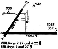
| A81-APT | ACTVT REIL RWY 09 & 27; MIRL RWY 04/22 & 09/27 - CTAF. MIRL RWY 04/22 & 09/27 PRESET LOW INTST; INCR INTST - CTAF. |
Runways
Runway Summary
| Runways: | 04/22 09/27 |
| Longest Runway: | 09/27 is 5000 ft (1524 m) long |
| Runways with an Instrument Approach: |
KFKR Airport Runway Details
| Runway 04/22 | 2527 ft x 70 ft (770 m x 21 m) | |
| Surface: | Asphalt - Excellent condition - No special surface treatment | |
| Runway Edge Lights: | Medium Intensity | |
Runway Weight Bearing Capacity (in thousands of pounds) |
||
| Single Wheel Landing Gear: | 12.5 | |
| Dual Wheel Landing Gear: | 20.0 | |
Runway 04 |
Runway 22 |
|
Elevation: |
856.6 | 857.3 |
Latitude: |
40-16-19.3840N | 40-16-40.0430N |
Longitude: |
086-34-08.9050W | 086-33-50.5810W |
|
Runway True Alignment: |
034 | 214 |
Glide Path Angle: |
0.0 degrees | 4.0 degrees |
Runway Markings Type: |
Nonprecision Instrument | Nonprecision Instrument |
Runway Markings Condition: |
Fair | Fair |
Object at End: |
CROPS | ROAD |
Object Height: |
10 | 19 |
Distance from End: |
200 | 370 |
Object Centerline Offset: |
0 ft. left and right of centerline | 140 ft. right of centerline |
Visual Glide Slope Indicators: |
2-Light PAPI On Right Side Of Runway | |
REIL: |
No | No |
Touchdown Lights: |
No | No |
Centerline Lights: |
No | No |
Threshold Crossing Height: |
25 |
| Runway 09/27 | 5000 ft x 75 ft (1524 m x 23 m) | |
| Runway Length Source: | 3RD PARTY SURVEY as of 03/26/2010 | |
| Surface: | Asphalt - Excellent condition - No special surface treatment | |
| Runway Edge Lights: | Medium Intensity | |
Runway 09 |
Runway 27 |
|
Elevation: |
856.2 | 860.7 |
Latitude: |
40-16-21.6491N | 40-16-21.6172N |
Longitude: |
086-34-08.0011W | 086-33-03.4934W |
|
Runway True Alignment: |
090 | 270 |
Glide Path Angle: |
3.0 degrees | 3.0 degrees |
Runway Markings Type: |
Nonprecision Instrument | Nonprecision Instrument |
Runway Markings Condition: |
Fair | Fair |
Object at End: |
CROPS | |
Object Height: |
10 | |
Distance from End: |
200 | |
Object Centerline Offset: |
0 ft. left and right of centerline | 140 ft. right of centerline |
Visual Glide Slope Indicators: |
2-Light PAPI On Left Side Of Runway | 2-Light PAPI On Left Side Of Runway |
REIL: |
Yes | Yes |
Threshold Crossing Height: |
25 | 25 |
Services
Airframe Repair: |
Major |
Powerplant Repair: |
Major |
Bottled Oxygen: |
None |
Bulk Oxygen: |
None |
Fuel Available: |
100LL, Jet A |
Landing Fees: |
No |
Parking: |
Tiedowns available |
Maps & Diagrams
KFKR Sectional
Flight Planning
at skyvector.com
at skyvector.com