Location
Latitude: |
43-01-54.3000N (43.03175) |
Longitude: |
078-10-10.8000W (-78.169667) |
Elevation: |
913.5 feet MSL (278 m MSL) |
Magnetic Variation: |
10.9 W (as of April 2024 from WMM2020 model) |
Time Zone: |
UTC -5.0 (Standard Time) UTC -4.0 (Daylight Savings Time) |
From City: |
02 N.M. N of Batavia, New York |
Found On: |
Detroit Chart |
FAA Region: |
AEA |
Contacts
Manager: |
Publicly owned: |
| JASON LONG 4701 E. SAILE DRIVE BATAVIA, NY 14020 585-344-8532 |
MR. TIMOTHY HENS GENESEE CO. SUPT. OF HWY., 153 CEDAR STREET BATAVIA, NY 14020 585-344-8508 |
Operations
Airport Status: |
Operational |
Facility Use: |
Public |
Type: |
Airport |
Control tower: |
No |
Attendance (Months/Days/Hours): |
Months/Days/Hours APR-OCT/ALL/0730-2000 |
Boundary ARTCC: |
ZOB (Cleveland) |
Responsible ARTCC: |
ZOB (Cleveland) |
Lighting Schedule: |
SEE RMK |
Segmented Circle Indicator: |
Yes |
Traffic Pattern Altitude (MSL): |
1914 feet (583 m) |
NOTAMs Facility: |
GVQ |
NOTAM-D Service: |
Yes |
International Airport of Entry: |
No |
Customs Landing Rights: |
No |
Military Landing Rights: |
Yes |
Civil/Military Joint Use: |
No |
Based Aircraft
| Single Engine: | 28 |
| Multi Engine: | 3 |
| Jet Engine: | 8 |
| GA Helicopters: | 2 |
Annual Operations (as of 08/12/2021)
| Total Operations: | 40000 | |
| Air Taxi: | 800 | 2.0% |
| GA Local: | 22800 | 57.0% |
| GA Itinerant: | 15600 | 39.0% |
| Military Aircraft: | 800 | 2.0% |
Communications
| CTAF: | 122.700 |
| Unicom: | 122.700 |
| Clearance Del.: | 121.8 121.8 121.8 |
| Approach: | ROCHESTER |
| Departure: | ROCHESTER |
| AWOS-3PT: | 127.525 (585-343-6369) |
Fixed Based Operators (FBOs) & Fuel
(Click on a business for detail)
Please help us keep this information up to date. This is a FREE SERVICE just like everything else on Airport Guide! If you see that a business needs to be added, modified, or deleted please fill out our Update Form.
To add, modify, or delete a business click here.
Please help us keep this information up to date. This is a FREE SERVICE just like everything else on Airport Guide! If you see that a business needs to be added, modified, or deleted please fill out our Update Form.
Area Code: 716 |
| Business Name | Frequency | Phone | Fuel Grade |
|---|---|---|---|
| Boshart Enterprises
Website Update FBO info |
122.7 | 716-344-1749 | 100LL, Jet A w/Prist |

|
Phillips | 100LL - 2.60 USD per gallon on 10/4/01 |
Pumps or Trucks Full service FBO during operating hours |
|
|
Phillips | Jet A - 2.25 USD per gallon on 10/4/01 |
Pumps or Trucks Jet A contains Prist additive. Full service FBO during operating hours. |
| Great Lakes Aviation, Inc.
Update FBO info |
Unicom 122.7 | 343-6200 | |
| Jar-Tech Avionics, Inc.
Update FBO info |
Unicom 122.7 | 345-1925 | 100LL, Jet A |
| Ravenaire, L.L.C.
Website Update FBO info |
122.7 | 716-343-7367 | 100LL, Jet A w/Prist |
|
|
Phillips | 100LL - 2.60 USD per gallon on 10/4/01 |
Pumps or Trucks |
|
|
Phillips | Jet A - 2.25 USD per gallon on 10/4/01 |
Pumps or Trucks Jet A contains Prist additive. |
Flight Service Stations
| Primary | Alternate | |
| FSS on Field: | N | |
| FSS Name (ID): | Buffalo(BUF) | |
| Frequency: | ||
| Toll Free Phone: | 1-800-WX-BRIEF |
Instrument Procedures / Charts
FAA Terminal Procedures valid from 0901Z 03/21/24 to 0901Z 04/18/24.
There are various types of charts available for an airport. They are listed in the Page Type column. Here is a legend for those types:
APD - Airport Diagram
DP - Departure Procedure Charts
HOT - Hot Spots
IAP - Instrument Approach Procedure Charts
MIN - Minimums
STAR - Standard Terminal Arrival Charts
| Page Type | Page Name | Volume | Action Since Last Cycle |
|---|---|---|---|
| IAP | ILS OR LOC RWY 28 | NE-2 | |
| IAP | RNAV (GPS) RWY 10 | NE-2 | |
| IAP | RNAV (GPS) RWY 28 | NE-2 | |
| IAP | VOR/DME-A | NE-2 | |
| MIN | ALTERNATE MINIMUMS | NE-2 | |
| MIN | TAKEOFF MINIMUMS | NE-2 |
Terminal Procedures are only available for airports in several countries with more being added all the time. If you are looking for a specific country's charts, please send an email to support(at)airportguide.com stating the country name. This will be used to prioritize the implementation.
Navigation Aids (Navaids) near KGVQ
| Dist (NM) | ID | Morse Code | Name | Type | Freq | True Hdg | Mag Hdg |
|---|---|---|---|---|---|---|---|
| 17.6 | AVN | . _ . . . _ _ . | Avon | NDB | 344 | 94 | 105 |
| 21.2 | BU | _ . . . . . _ | Klump | NDB | 231 | 265 | 276 |
| 21.8 | BUF | _ . . . . . _ . . _ . | Buffalo | DME | 116.4 | 253 | 264 |
| 22.4 | ROC | . _ . _ _ _ _ . _ . | Rochester | VOR-DME | 110.00 | 76 | 87 |
| 22.6 | GEE | _ _ . . . | Geneseo | VOR-DME | 108.20 | 121 | 132 |
| 25.4 | BUF | _ . . . . . _ . . _ . | Buffalo | VOT | 109.00 | 257 | 268 |
| 29.7 | IA | . . . _ | Kathi | NDB | 329 | 279 | 290 |
| 29.9 | GB | _ _ . _ . . . | Plazz | NDB | 204 | 251 | 262 |
| 35.0 | IAG | . . . _ _ _ . | Niagara Falls | TACAN | 111.00 | 278 | 289 |
| 45.5 | LYS | . _ . . _ . _ _ . . . | Olean | NDB | 360 | 189 | 200 |
| 48.0 | SN | St. Catharines | NDB | 408 | 278 | 289 | |
| 54.2 | PYA | . _ _ . _ . _ _ . _ | Penn Yan | NDB | 260 | 115 | 126 |
| 57.0 | ELZ | . . _ . . _ _ . . | Wellsville | DME | 115.85 | 172 | 183 |
| 58.5 | DKK | _ . . _ . _ _ . _ | Dunkirk | DME | 116.2 | 236 | 247 |
| 61.7 | IOO | Oshawa | DME | 111.35 | 329 | 340 | |
| 62.1 | OO | Oshawa | NDB | 391 | 329 | 340 | |
| 63.5 | TZ | Gibraltar Point | NDB | 257 | 303 | 314 | |
| 64.5 | ITZ | City Centre | DME | 110.15 | 304 | 315 | |
| 65.7 | ZZR | Severn | NDB | 317 | 20 | 31 | |
| 65.8 | JHW | . _ _ _ . . . . . _ _ | Jamestown | VOR-DME | 114.70 | 220 | 231 |
Nearby Airports with Fuel
Notices to Airmen (NOTAMS)
Remarks
| A110*G | THIS AIRPORT HAS BEEN SURVEYED BY THE NATIONAL GEODETIC SURVEY. |
| A110-1 | RWY 10: +5' BERM 220' LEFT, WITHIN SIDE PRIMARY SURFACE (1597'-1997' DOWN RWY) |
| A110-2 | FOR CD CTC CLEVELAND ARTCC AT 440-774-0490. |
| A16 | CALL ARPT AT 585-344-8532 DURING ATTENDED HOURS. |
| A52-28 | 110 FT TWR 1730 FT FM THR 1000 FT L OUTSIDE CLEAR ZONE. |
| A58-10 | +8 FT FENCE AT 460 FT FM CNTLN. |
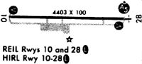
| A81-APT | ACTVT MALSR RWY 28; REIL RWY 10; PAPI RWY 10 & 28; HIRL RWY 10/28 - CTAF. |
| E111 | EXISTED PRIOR TO 1959. |
Runways
Runway Summary
| Runways: | 10/28 |
| Longest Runway: | 10/28 is 5499 ft (1676 m) long |
| Runways with an Instrument Approach: | 28 |
KGVQ Airport Runway Details
| Runway 10/28 | 5499 ft x 100 ft (1676 m x 30 m) | |
| Runway Length Source: | FAA as of 08/30/2011 | |
| Surface: | Asphalt - Good condition - Saw-cut or plastic grooved | |
| Runway Edge Lights: | High Intensity | |
Runway Weight Bearing Capacity (in thousands of pounds) |
||
| Single Wheel Landing Gear: | 21.0 | |
| Dual Wheel Landing Gear: | 33.0 | |
Runway 10 |
Runway 28 |
|
Elevation: |
911.6 | 910.6 |
Latitude: |
43-01-54.7066N | 43-01-53.9162N |
Longitude: |
078-10-47.7848W | 078-09-33.7520W |
|
Runway True Alignment: |
091 | 271 |
ILS Type: |
ILS | |
Glide Path Angle: |
3.0 degrees | 3.0 degrees |
Traffic Pattern: |
Left | Left |
Runway Markings Type: |
Nonprecision Instrument | Precision Instrument |
Runway Markings Condition: |
Good | Good |
Object at End: |
FENCE | |
Object Height: |
8 | |
Object Marked/Lighted?: |
Lighted | |
Distance from End: |
200 | |
Object Centerline Offset: |
460 ft. right of centerline | |
Visual Glide Slope Indicators: |
2-Light PAPI On Left Side Of Runway | 2-Light PAPI On Left Side Of Runway |
Approach Light System: |
1,400 Foot Medium Intensity Approach Lighting System With Runway Alignment Indicator Lights | |
REIL: |
Yes | No |
Threshold Crossing Height: |
40 | 62 |
Services
Airframe Repair: |
Major |
Powerplant Repair: |
Major |
Bottled Oxygen: |
None |
Bulk Oxygen: |
None |
Fuel Available: |
100LL, Jet A |
Landing Fees: |
Yes |
Parking: |
Hangars and tiedowns available |
Maps & Diagrams
KGVQ Sectional
Flight Planning
at skyvector.com
at skyvector.com