Location
Latitude: |
43-07-08.9170N (43.119144) |
Longitude: |
077-40-18.7280W (-77.671869) |
Elevation: |
558.9 feet MSL (170 m MSL) |
Magnetic Variation: |
11.2 W (as of April 2024 from WMM2020 model) |
Time Zone: |
UTC -5.0 (Standard Time) UTC -4.0 (Daylight Savings Time) |
From City: |
03 N.M. SW of Rochester, New York |
Found On: |
Detroit Chart |
FAA Region: |
AEA |
Contacts
Manager: |
Publicly owned: |
| ANDREW MOORE 1200 BROOKS AVE ROCHESTER, NY 14624 585-753-7056 |
COUNTY OF MONROE COUNTY OFFICE BLDG ROCHESTER, NY 14614 585-753-7020 |
Operations
Airport Status: |
Operational |
Facility Use: |
Public |
Type: |
Airport |
Activation Date: |
03/1940 |
Control tower: |
Yes |
Attendance (Months/Days/Hours): |
Months/Days/Hours ALL/ALL/ALL |
Boundary ARTCC: |
ZOB (Cleveland) |
Responsible ARTCC: |
ZOB (Cleveland) |
Segmented Circle Indicator: |
No |
Traffic Pattern Altitude (MSL): |
1559 feet (475 m) |
NOTAMs Facility: |
ROC |
NOTAM-D Service: |
Yes |
International Airport of Entry: |
Yes |
Customs Landing Rights: |
No |
Military Landing Rights: |
Yes |
Civil/Military Joint Use: |
No |
Aircraft Rescue and Firefighting: |
Class I ARFF Index: C Air Carrier Service: Scheduled Certification Date: 05/1973 |
Based Aircraft
| Single Engine: | 45 |
| Multi Engine: | 18 |
| Jet Engine: | 23 |
| Military Aircraft: | 2 |
Annual Operations (as of 12/31/2022)
| Total Operations: | 81952 | |
| Commercial: | 27649 | 33.7% |
| Air Taxi: | 11888 | 14.5% |
| GA Local: | 16988 | 20.7% |
| GA Itinerant: | 23308 | 28.4% |
| Military Aircraft: | 2119 | 2.6% |
Communications
| Unicom: | 122.950 |
| Tower: | ROCHESTER 118.3 254.3 Hrs: 24 |
| Clearance Del.: | 343.65 |
| Ground: | 121.7 |
| Approach: | ROCHESTER 119.55 ;330-160 123.7 ;161-329 269.6 ;330-160 322.3 ;161-329 Hrs: 24 |
| Departure: | ROCHESTER 119.55 ;330-160 123.7 ;161-329 269.6 ;330-160 322.3 ;161-329 Hrs: 24 |
| ATIS: | 124.825 Hrs: 24 |
| ASOS: | 124.825 (585-235-7322) |
| EMERG: | 243.0 |
| CLASS C: | 119.55 ;330-160 |
| EMERG: | 121.5 |
| CLASS C: | 269.6 ;330-160 |
| CLASS C: | 322.3 ;161-329 |
| CLASS C: | 123.7 ;161-329 |
Fixed Based Operators (FBOs) & Fuel
(Click on a business for detail)
Please help us keep this information up to date. This is a FREE SERVICE just like everything else on Airport Guide! If you see that a business needs to be added, modified, or deleted please fill out our Update Form.
To add, modify, or delete a business click here.
Please help us keep this information up to date. This is a FREE SERVICE just like everything else on Airport Guide! If you see that a business needs to be added, modified, or deleted please fill out our Update Form.
Area Code: 716 |
| Business Name | Frequency | Phone | Fuel Grade |
|---|---|---|---|
| Piedmont Hawthorne
Website Update FBO info |
122.95 Unicom | 716-328-2720 | 100LL, Jet A |

|
 Air BP |
100LL - 3.03 USD per gallon on 9/24/01 |
Trucks Price includes all taxes. |
|
|
Air BP |
Jet A - 2.85 USD per gallon on 9/24/01 |
Trucks Price includes all taxes. |
| US Airports Flight Support
Update FBO info |
328-2280 | Jet A |
Flight Service Stations
| Primary | Alternate | |
| FSS on Field: | N | |
| FSS Name (ID): | Buffalo(BUF) | |
| Frequency: | ||
| Toll Free Phone: | 1-800-WX-BRIEF |
Instrument Procedures / Charts
FAA Terminal Procedures valid from 0901Z 03/21/24 to 0901Z 04/18/24.
There are various types of charts available for an airport. They are listed in the Page Type column. Here is a legend for those types:
APD - Airport Diagram
DP - Departure Procedure Charts
HOT - Hot Spots
IAP - Instrument Approach Procedure Charts
MIN - Minimums
STAR - Standard Terminal Arrival Charts
| Page Type | Page Name | Volume | Action Since Last Cycle |
|---|---|---|---|
| APD | AIRPORT DIAGRAM | NE-2 | Changed |
| DP | XEROX SEVEN | NE-2 | |
| DP | XEROX SEVEN[DELIMITER] CONT.1 | NE-2 | |
| HOT | HOT SPOT | NE-2 | Deleted |
| IAP | ILS OR LOC RWY 04 | NE-2 | |
| IAP | ILS OR LOC RWY 22 | NE-2 | |
| IAP | ILS OR LOC RWY 28 | NE-2 | |
| IAP | ILS RWY 04 (CAT II) | NE-2 | |
| IAP | ILS RWY 04 (SA CAT I) | NE-2 | |
| IAP | RNAV (GPS) RWY 04 | NE-2 | |
| IAP | RNAV (GPS) RWY 07 | NE-2 | |
| IAP | RNAV (GPS) RWY 10 | NE-2 | |
| IAP | RNAV (GPS) RWY 22 | NE-2 | |
| IAP | RNAV (GPS) RWY 25 | NE-2 | |
| IAP | RNAV (GPS) RWY 28 | NE-2 | |
| IAP | VOR RWY 04 | NE-2 | |
| MIN | ALTERNATE MINIMUMS | NE-2 | |
| MIN | TAKEOFF MINIMUMS | NE-2 |
Terminal Procedures are only available for airports in several countries with more being added all the time. If you are looking for a specific country's charts, please send an email to support(at)airportguide.com stating the country name. This will be used to prioritize the implementation.
Navigation Aids (Navaids) near ROC
| Dist (NM) | ID | Morse Code | Name | Type | Freq | True Hdg | Mag Hdg |
|---|---|---|---|---|---|---|---|
| 0.1 | ROC | . _ . _ _ _ _ . _ . | Rochester | VOR-DME | 110.00 | 210 | 221 |
| 7.8 | AVN | . _ . . . _ _ . | Avon | NDB | 344 | 213 | 224 |
| 17.3 | GEE | _ _ . . . | Geneseo | VOR-DME | 108.20 | 188 | 199 |
| 39.3 | PYA | . _ _ . _ . _ _ . _ | Penn Yan | NDB | 260 | 136 | 147 |
| 43.5 | BU | _ . . . . . _ | Klump | NDB | 231 | 260 | 271 |
| 44.2 | BUF | _ . . . . . _ . . _ . | Buffalo | DME | 116.4 | 255 | 266 |
| 47.8 | BUF | _ . . . . . _ . . _ . | Buffalo | VOT | 109.00 | 257 | 268 |
| 51.1 | IA | . . . _ | Kathi | NDB | 329 | 269 | 280 |
| 52.3 | GB | _ _ . _ . . . | Plazz | NDB | 204 | 254 | 265 |
| 56.1 | ZZR | Severn | NDB | 317 | 1 | 12 | |
| 56.4 | IAG | . . . _ _ _ . | Niagara Falls | TACAN | 111.00 | 270 | 281 |
| 58.0 | LYS | . _ . . _ . _ _ . . . | Olean | NDB | 360 | 210 | 221 |
| 60.4 | UTR | Trenton | TACAN | 109.70 | 5 | 16 | |
| 60.6 | FZ | . . _ . _ _ . . | Falln | NDB | 220 | 79 | 91 |
| 63.4 | ELZ | . . _ . . _ _ . . | Wellsville | DME | 115.85 | 193 | 204 |
| 64.3 | SYR | . . . _ . _ _ . _ . | Syracuse | VORTAC | 117.00 | 87 | 99 |
| 65.2 | ITH | . . _ . . . . | Ithaca | DME | 111.8 | 124 | 135 |
| 65.5 | YTR | Trenton | NDB | 215 | 10 | 21 | |
| 66.3 | ALP | . _ . _ . . . _ _ . | Alpine | NDB | 245 | 142 | 153 |
| 66.5 | 6M | Belleville | NDB | 283 | 13 | 24 |
Nearby Airports with Fuel
Notices to Airmen (NOTAMS)
Remarks
| A110-1 | NO PRACTICE APCHS OR MAINT ENG RUN-UPS BTN 2300-0600. |
| A110-10 | MULTIPLE UNSHIELDED LGTS IN FINAL APCH AREA RY 28. |
| A110-12 | TWY 'A2' CLSD TO HEAVY ACFT. |
| A110-15 | TWY 'F' FROM TWY 'F1' TO RY 07 CLSD TO ACFT W/WINGSPAN GREATER THAN 100 FT. |
| A110-16 | PAPI RWY 22; PAPI RWY 10, RWY 25 AND RWY 28 OPERATE 24 HRS. |
| A110-17 | TERMINAL RAMP IS UNCONTROLLED. DO NOT CALL FOR PUSH/POWER BACK. ADVISE GROUND CONTROL WHEN READY TO TAXI FOR DEPARTURE. |
| A110-18 | RWY 7/25 CLSD TO SKED ACR OPS MORE THAN 9 PAX SEATS AND NON SKED ACR OPS MORE THAN 30 PAX SEATS. |
| A110-4 | BE ALERT DURG LNDG/TKOF RYS 25 & 28 - THLDS IN CLOSE PROXIMITY TO EACH OTHER. |
| A110-5 | BIRDS; DEER & COYOTE ON & INVOF ARPT. |
| A110-9 | 80 FT OBST LGTD TWR 1250 FT WEST OF RY 04/22 CNTRLN 1000 FT SOUTH OF EXTDD CNTRLN RY 10/28. |
| A48-07 | RY 07 REIL CONTROLLED BY ATCT BUT NOT MONITORED. |
| A48-10 | RY 10 REIL CONTROLLED BY ATCT BUT NOT MONITORED. |
| A48-25 | RY 25 REIL CONTROLLED BY ATCT BUT NOT MONITORED. |
| A57-10 | RWY 10 APCH RATIO 26:1 TO DSPLCD THLD. |
| A57-28 | RWY 28 APCH RATIO 26:1 TO DSPLCD THLD. |
| A70-FUEL-J8 | FOR DOD ACFT. |
| E111 | ARPT EXISTED PRIOR TO 1959 |
| E147 | TPA: 841 FT AGL SINGL ENG, 1441 FT AGL MULT ENG/TURBOPROP/JET. |
| E60-28 | ENGINEERED MATERIALS ARRESTING SYSTEM (EMAS) 368 FT IN LENGTH BY 160 FT IN WIDTH LCTD AT THE DER 28. |
| E79 | FLIGHT NOTIFICATION SERVICE (ADCUS ) AVAILABLE. |
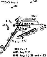
Runways
Runway Summary
| Runways: | 04/22 07/25 10/28 |
| Longest Runway: | 04/22 is 8001 ft (2439 m) long |
| Runways with an Instrument Approach: | 04, 22, 28 |
ROC Airport Runway Details
| Runway 04/22 | 8001 ft x 150 ft (2439 m x 46 m) | |
| Runway Length Source: | 3RD PARTY SURVEY as of 06/06/2018 | |
| Surface: | Asphalt - Good condition - Saw-cut or plastic grooved | |
| Runway Pavement Class: | 55 /R/C/X/T | |
| Runway Edge Lights: | High Intensity | |
Runway Weight Bearing Capacity (in thousands of pounds) |
||
| Single Wheel Landing Gear: | 126.0 | |
| Dual Wheel Landing Gear: | 160.0 | |
| Dual Tandem Wheel Landing Gear: | 265.0 | |
Runway 04 |
Runway 22 |
|
Elevation: |
527.4 | 558.9 |
Latitude: |
43-06-24.7680N | 43-07-32.0402N |
Longitude: |
077-41-15.7534W | 077-40-19.1601W |
|
Runway True Alignment: |
032 | 212 |
ILS Type: |
ILS | ILS |
Glide Path Angle: |
0.0 degrees | 3.0 degrees |
Traffic Pattern: |
Left | Right |
Runway Markings Type: |
Precision Instrument | Precision Instrument |
Runway Markings Condition: |
Good | Good |
Object at End: |
TREES | TREE |
Object Height: |
89 | 54 |
Distance from End: |
3080 | 2080 |
Object Centerline Offset: |
760 ft. right of centerline | 520 ft. right of centerline |
Visual Glide Slope Indicators: |
4-Light PAPI On Left Side Of Runway | |
Runway Visual Range (RVR): |
Touchdown, Rollout | Touchdown, Rollout |
Approach Light System: |
Standard 2,400 Foot High Intensity Approach Lighting System With Sequenced Flashers, Cat. II or III Config. | 1,400 Foot Medium Intensity Approach Lighting System With Runway Alignment Indicator Lights |
Touchdown Lights: |
Yes | No |
Centerline Lights: |
Yes | Yes |
Threshold Crossing Height: |
67 | |
Declared Distances |
||
Take Off Run Avbl. (TORA): |
8001 | 8001 |
Take Off Distance Avbl. (TODA): |
8001 | 8001 |
Actual Stop Dist. Avbl. (ASDA): |
8001 | 8001 |
Landing Dist. Avbl. (LDA): |
8001 | 8001 |
| Runway 07/25 | 4000 ft x 100 ft (1219 m x 30 m) | |
| Runway Length Source: | 3RD PARTY SURVEY as of 06/06/2018 | |
| Surface: | Asphalt - Good condition - No special surface treatment | |
| Runway Pavement Class: | 95 /F/C/X/T | |
| Runway Edge Lights: | Medium Intensity | |
Runway Weight Bearing Capacity (in thousands of pounds) |
||
| Single Wheel Landing Gear: | 32.0 | |
| Dual Wheel Landing Gear: | 42.0 | |
Runway 07 |
Runway 25 |
|
Elevation: |
545.0 | 536.0 |
Latitude: |
43-06-58.2078N | 43-07-15.6329N |
Longitude: |
077-40-21.3180W | 077-39-32.9125W |
|
Runway True Alignment: |
064 | 244 |
Glide Path Angle: |
0.0 degrees | 3.0 degrees |
Traffic Pattern: |
Right | Left |
Runway Markings Type: |
Nonprecision Instrument | Nonprecision Instrument |
Runway Markings Condition: |
Good | Good |
Object at End: |
POLE | TREE |
Object Height: |
58 | 82 |
Object Marked/Lighted?: |
Lighted | |
Distance from End: |
1740 | 2720 |
Object Centerline Offset: |
760 ft. right of centerline | 520 ft. right of centerline |
Visual Glide Slope Indicators: |
4-Light PAPI On Right Side Of Runway | |
REIL: |
Yes | Yes |
Threshold Crossing Height: |
40 | |
Declared Distances |
||
Take Off Run Avbl. (TORA): |
4000 | 4000 |
Take Off Distance Avbl. (TODA): |
4000 | 4000 |
Actual Stop Dist. Avbl. (ASDA): |
4000 | 4000 |
Landing Dist. Avbl. (LDA): |
4000 | 4000 |
| Runway 10/28 | 6402 ft x 150 ft (1951 m x 46 m) | |
| Runway Length Source: | 3RD PARTY SURVEY as of 06/06/2018 | |
| Surface: | Asphalt - Good condition - Saw-cut or plastic grooved | |
| Runway Pavement Class: | 47 /R/C/X/T | |
| Runway Edge Lights: | High Intensity | |
Runway Weight Bearing Capacity (in thousands of pounds) |
||
| Single Wheel Landing Gear: | 126.0 | |
| Dual Wheel Landing Gear: | 160.0 | |
| Dual Tandem Wheel Landing Gear: | 265.0 | |
Runway 10 |
Runway 28 |
|
Elevation: |
554.9 | 541.4 |
Latitude: |
43-07-22.0052N | 43-07-24.5873N |
Longitude: |
077-40-39.4430W | 077-39-13.1957W |
|
Runway True Alignment: |
088 | 268 |
ILS Type: |
ILS/DME | |
Glide Path Angle: |
3.0 degrees | 3.0 degrees |
Traffic Pattern: |
Right | Left |
Runway Markings Type: |
Nonprecision Instrument | Precision Instrument |
Runway Markings Condition: |
Good | Good |
Arresting Device: |
EMAS | |
Object at End: |
TREES | TREES |
Object Height: |
62 | 68 |
Distance from End: |
1330 | 1213 |
Object Centerline Offset: |
760 ft. right of centerline | 520 ft. right of centerline |
Visual Glide Slope Indicators: |
4-Light PAPI On Left Side Of Runway | 4-Light PAPI On Left Side Of Runway |
Runway Visual Range (RVR): |
Touchdown, Rollout | Touchdown, Rollout |
Approach Light System: |
1,400 Foot Medium Intensity Approach Lighting System With Runway Alignment Indicator Lights | |
REIL: |
Yes | |
Threshold Crossing Height: |
53 | 57 |
Threshold Elevation: |
555.0 | 541.4 |
Displaced Threshold: |
298 | 600 |
Threshold Latitude: |
43-07-22.1258N | 43-07-24.3441N |
Threshold Longitude: |
077-40-35.4335W | 077-39-21.2821W |
Declared Distances |
||
Take Off Run Avbl. (TORA): |
6402 | 6402 |
Take Off Distance Avbl. (TODA): |
6402 | 6402 |
Actual Stop Dist. Avbl. (ASDA): |
5802 | 6402 |
Landing Dist. Avbl. (LDA): |
5502 | 5802 |
Services
Airframe Repair: |
Minor |
Powerplant Repair: |
Minor |
Fuel Available: |
100LL, MOGAS |
Landing Fees: |
No |
Parking: |
Tiedowns available |
Maps & Diagrams

ROC Sectional
Flight Planning
at skyvector.com
at skyvector.com