Location
Latitude: |
43-10-52.3000N (43.181194) |
Longitude: |
077-54-55.8000W (-77.9155) |
Elevation: |
664.9 feet MSL (203 m MSL) |
Magnetic Variation: |
11 W (as of April 2024 from WMM2020 model) |
Time Zone: |
UTC -5.0 (Standard Time) UTC -4.0 (Daylight Savings Time) |
From City: |
03 N.M. SE of Brockport, New York |
Found On: |
Detroit Chart |
FAA Region: |
AEA |
Contacts
Manager: |
Privately owned: |
| CODY JOHNSON 21 EISENHAUER BROCKPORT, NY 14420 585-880-3298 |
BIG FELLA ENTERPRISES INC. 21 EISENHAUER BROCKPORT, NY 14420 (585) 233-5117 |
Operations
Airport Status: |
Operational |
Facility Use: |
Public |
Type: |
Airport |
Activation Date: |
04/1969 |
Control tower: |
No |
Attendance (Months/Days/Hours): |
Months/Days/Hours ALL/ALL/1000-1600 |
Boundary ARTCC: |
ZOB (Cleveland) |
Responsible ARTCC: |
ZOB (Cleveland) |
Segmented Circle Indicator: |
No |
Traffic Pattern Altitude (MSL): |
1665 feet (507 m) |
NOTAMs Facility: |
BUF |
NOTAM-D Service: |
Yes |
Based Aircraft
| Single Engine: | 22 |
Annual Operations (as of 06/05/2018)
| Total Operations: | 16100 | |
| GA Local: | 14000 | 87.0% |
| GA Itinerant: | 1500 | 9.3% |
| Military Aircraft: | 600 | 3.7% |
Communications
| CTAF: | 122.700 |
| Unicom: | 122.700 |
| Approach: | ROCHESTER 123.7 123.7 |
| Departure: | ROCHESTER 123.7 123.7 |
Fixed Based Operators (FBOs) & Fuel
(Click on a business for detail)
Please help us keep this information up to date. This is a FREE SERVICE just like everything else on Airport Guide! If you see that a business needs to be added, modified, or deleted please fill out our Update Form.
To add, modify, or delete a business click here.
Please help us keep this information up to date. This is a FREE SERVICE just like everything else on Airport Guide! If you see that a business needs to be added, modified, or deleted please fill out our Update Form.
Area Code: 716 |
| Business Name | Frequency | Phone | Fuel Grade |
|---|---|---|---|
| Ledgedale Flying Services
Update FBO info |
100LL |
Flight Service Stations
| Primary | Alternate | |
| FSS on Field: | N | |
| FSS Name (ID): | Buffalo(BUF) | |
| Frequency: | ||
| Toll Free Phone: | 1-800-WX-BRIEF |
Instrument Procedures / Charts
FAA Terminal Procedures valid from 0901Z 03/21/24 to 0901Z 04/18/24.
There are various types of charts available for an airport. They are listed in the Page Type column. Here is a legend for those types:
APD - Airport Diagram
DP - Departure Procedure Charts
HOT - Hot Spots
IAP - Instrument Approach Procedure Charts
MIN - Minimums
STAR - Standard Terminal Arrival Charts
| Page Type | Page Name | Volume | Action Since Last Cycle |
|---|---|---|---|
| IAP | RNAV (GPS) RWY 28 | NE-2 | |
| MIN | TAKEOFF MINIMUMS | NE-2 |
Terminal Procedures are only available for airports in several countries with more being added all the time. If you are looking for a specific country's charts, please send an email to support(at)airportguide.com stating the country name. This will be used to prioritize the implementation.
Navigation Aids (Navaids) near 7G0
| Dist (NM) | ID | Morse Code | Name | Type | Freq | True Hdg | Mag Hdg |
|---|---|---|---|---|---|---|---|
| 11.3 | ROC | . _ . _ _ _ _ . _ . | Rochester | VOR-DME | 110.00 | 109 | 120 |
| 12.1 | AVN | . _ . . . _ _ . | Avon | NDB | 344 | 148 | 159 |
| 22.3 | GEE | _ _ . . . | Geneseo | VOR-DME | 108.20 | 158 | 169 |
| 34.0 | BU | _ . . . . . _ | Klump | NDB | 231 | 251 | 262 |
| 35.4 | BUF | _ . . . . . _ . . _ . | Buffalo | DME | 116.4 | 244 | 255 |
| 38.7 | BUF | _ . . . . . _ . . _ . | Buffalo | VOT | 109.00 | 248 | 259 |
| 40.6 | IA | . . . _ | Kathi | NDB | 329 | 264 | 275 |
| 43.6 | GB | _ _ . _ . . . | Plazz | NDB | 204 | 245 | 256 |
| 45.9 | IAG | . . . _ _ _ . | Niagara Falls | TACAN | 111.00 | 265 | 276 |
| 49.6 | PYA | . _ _ . _ . _ _ . _ | Penn Yan | NDB | 260 | 130 | 141 |
| 53.8 | ZZR | Severn | NDB | 317 | 13 | 24 | |
| 56.9 | LYS | . _ . . _ . _ _ . . . | Olean | NDB | 360 | 199 | 210 |
| 58.6 | SN | St. Catharines | NDB | 408 | 268 | 279 | |
| 58.8 | UTR | Trenton | TACAN | 109.70 | 16 | 27 | |
| 61.1 | IOO | Oshawa | DME | 111.35 | 316 | 327 | |
| 61.7 | OO | Oshawa | NDB | 391 | 316 | 327 | |
| 64.7 | YTR | Trenton | NDB | 215 | 19 | 30 | |
| 65.6 | ELZ | . . _ . . _ _ . . | Wellsville | DME | 115.85 | 183 | 194 |
| 66.2 | YPQ | Peterborough | NDB | 379 | 339 | 350 | |
| 66.3 | 6M | Belleville | NDB | 283 | 23 | 34 |
Nearby Airports with Fuel
Notices to Airmen (NOTAMS)
Remarks
| A110-1 | DEER ON & INVOF ARPT + MIGRATORY BIRDS ON ARPT IN SPRING AND FALL. |
| A110-2 | FOR CD CTC CLEVELAND ARTCC AT 440-774-0490. |
| A17 | FOR ATTENDANCE OTHER HOURS MONDAY-FRIDAY CALL 585-233-5117. |
| A42-10 | MARKINGS FADED |
| A42-28 | MARKINGS FADED |
| A52-28 | RY 28 HAS TREES ON BOTH SIDES OF CNTRLN, +32 TO +50 FT HIGH, 750 - 900 FT FROM RY END |
| A58-10 | RWY 10, +5 FT ELECTRICAL BOXES 81 FT OUT AND 100 FT LEFT; +11 TO +16FT TREES, 104 -160FT FRM RWY, 172 - 183FT RT. |
| A58-28 | RY 28 HAS +5 FT ELECTRIC BOXES 61 FT FM RY END AND 100 FT RIGHT; +20 TO +33FT TREES, 13 - 32FT FRM RNWY,114 - 123FT LEFT. |
Runways
Runway Summary
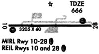
| Runways: | 10/28 |
| Longest Runway: | 10/28 is 4206 ft (1282 m) long |
| Runways with an Instrument Approach: |
7G0 Airport Runway Details
| Runway 10/28 | 4206 ft x 75 ft (1282 m x 23 m) | |
| Runway Length Source: | 3RD PARTY SURVEY as of 07/22/2011 | |
| Surface: | Asphalt - Good condition - No special surface treatment | |
Runway Weight Bearing Capacity (in thousands of pounds) |
||
| Single Wheel Landing Gear: | 12.0 | |
Runway 10 |
Runway 28 |
|
Elevation: |
656.4 | 662.5 |
Latitude: |
43-10-52.6435N | 43-10-51.8646N |
Longitude: |
077-55-24.1656W | 077-54-27.4184W |
|
Runway True Alignment: |
091 | 271 |
Glide Path Angle: |
0.0 degrees | 0.0 degrees |
Traffic Pattern: |
Left | Left |
Runway Markings Type: |
Nonprecision Instrument | Nonprecision Instrument |
Runway Markings Condition: |
Poor | Poor |
Object at End: |
BRUSH | TREES |
Object Height: |
18 | 37 |
Distance from End: |
292 | 759 |
Object Centerline Offset: |
0 ft. right of centerline | 148 ft. left of centerline |
REIL: |
No | No |
Services
Bottled Oxygen: |
None |
Bulk Oxygen: |
None |
Fuel Available: |
100LL |
Landing Fees: |
No |
Parking: |
Hangars and tiedowns available |
Maps & Diagrams
7G0 Sectional
Flight Planning
at skyvector.com
at skyvector.com