Location
Latitude: |
41-59-06.9000N (41.98525) |
Longitude: |
073-57-51.6000W (-73.964333) |
Elevation: |
147.4 feet MSL (45 m MSL) |
Magnetic Variation: |
12.9 W (as of April 2024 from WMM2020 model) |
Time Zone: |
UTC -5.0 (Standard Time) UTC -4.0 (Daylight Savings Time) |
From City: |
04 N.M. N of Kingston, New York |
Found On: |
New York Chart |
FAA Region: |
AEA |
Contacts
Manager: |
Privately owned: |
| TODD COGGESHALL 1161 FLATBUSH AVE KINGSTON, NY 12401 845-481-1559 |
KINGSTON-ULSTER ARPT INC. 1161 FLATBUSH RD KINGSTON, NY 12401 845-336-8400 |
Operations
Airport Status: |
Operational |
Facility Use: |
Public |
Type: |
Airport |
Activation Date: |
09/1961 |
Control tower: |
No |
Attendance (Months/Days/Hours): |
Months/Days/Hours JAN-DEC/ALL/0900-1700 |
Boundary ARTCC: |
ZNY (New York) |
Responsible ARTCC: |
ZNY (New York) |
Lighting Schedule: |
SEE RMK |
Segmented Circle Indicator: |
Yes |
Traffic Pattern Altitude (MSL): |
1147 feet (350 m) |
NOTAMs Facility: |
ISP |
NOTAM-D Service: |
Yes |
International Airport of Entry: |
No |
Customs Landing Rights: |
No |
Military Landing Rights: |
No |
Civil/Military Joint Use: |
No |
Based Aircraft
| Single Engine: | 25 |
| Multi Engine: | 2 |
| GA Helicopters: | 3 |
Annual Operations (as of 08/04/2022)
| Total Operations: | 8000 | |
| GA Local: | 7000 | 87.5% |
| GA Itinerant: | 1000 | 12.5% |
Communications
| CTAF: | 122.800 |
| Unicom: | 122.800 |
| Approach: | NEW YORK 132.75 132.75 |
| Departure: | NEW YORK 132.75 132.75 |
Fixed Based Operators (FBOs) & Fuel
(Click on a business for detail)
Please help us keep this information up to date. This is a FREE SERVICE just like everything else on Airport Guide! If you see that a business needs to be added, modified, or deleted please fill out our Update Form.
To add, modify, or delete a business click here.
Please help us keep this information up to date. This is a FREE SERVICE just like everything else on Airport Guide! If you see that a business needs to be added, modified, or deleted please fill out our Update Form.
Area Code: 845 |
| Business Name | Frequency | Phone | Fuel Grade |
|---|---|---|---|
| River Aviation, Inc.
Update FBO info |
336-8400 | 100LL |
Flight Service Stations
| Primary | Alternate | |
| FSS on Field: | N | |
| FSS Name (ID): | New York(ISP) | |
| Frequency: | ||
| Toll Free Phone: | 1-800-WX-BRIEF |
Instrument Procedures / Charts
FAA Terminal Procedures valid from 0901Z 03/21/24 to 0901Z 04/18/24.
There are various types of charts available for an airport. They are listed in the Page Type column. Here is a legend for those types:
APD - Airport Diagram
DP - Departure Procedure Charts
HOT - Hot Spots
IAP - Instrument Approach Procedure Charts
MIN - Minimums
STAR - Standard Terminal Arrival Charts
| Page Type | Page Name | Volume | Action Since Last Cycle |
|---|---|---|---|
| IAP | RNAV (GPS) RWY 15 | NE-2 | |
| IAP | RNAV (GPS) RWY 33 | NE-2 | |
| MIN | TAKEOFF MINIMUMS | NE-2 |
Terminal Procedures are only available for airports in several countries with more being added all the time. If you are looking for a specific country's charts, please send an email to support(at)airportguide.com stating the country name. This will be used to prioritize the implementation.
Navigation Aids (Navaids) near 20N
| Dist (NM) | ID | Morse Code | Name | Type | Freq | True Hdg | Mag Hdg |
|---|---|---|---|---|---|---|---|
| 19.3 | PFH | . _ _ . . . _ . . . . . | Philmont | NDB | 272 | 33 | 46 |
| 20.2 | IGN | . . _ _ . _ . | Kingston | VOR-DME | 117.60 | 161 | 174 |
| 20.8 | PWL | . _ _ . . _ _ . _ . . | Pawling | VOR-DME | 114.30 | 128 | 141 |
| 24.6 | PO | . _ _ . _ _ _ | Meier | NDB | 403 | 180 | 193 |
| 27.6 | GBR | _ _ . _ . . . . _ . | Great Barrington | NDB | 395 | 64 | 77 |
| 27.7 | SKU | . . . _ . _ . . _ | Stanwyck | NDB | 261 | 187 | 200 |
| 27.7 | SKU | . . . _ . _ . . _ | Stanwyck | FAN MARKER | 187 | 200 | |
| 32.2 | SW | . . . . _ _ | Neely | NDB | 335 | 201 | 214 |
| 42.1 | MS | _ _ . . . | Monga | NDB | 359 | 252 | 265 |
| 44.5 | HUO | . . . . . . _ _ _ _ | Huguenot | VOR-DME | 116.10 | 219 | 232 |
| 45.7 | CMK | _ . _ . _ _ _ . _ | Carmel | VOR-DME | 116.60 | 157 | 170 |
| 45.7 | DNY | _ . . _ . _ . _ _ | Delancey | VOR-DME | 112.10 | 285 | 298 |
| 45.9 | ALB | . _ . _ . . _ . . . | Albany | VOT | 108.20 | 7 | 20 |
| 46.3 | ALB | . _ . _ . . _ . . . | Albany | VORTAC | 115.30 | 8 | 21 |
| 48.7 | CTR | _ . _ . _ . _ . | Chester | VOR-DME | 115.10 | 67 | 80 |
| 52.2 | HEU | . . . . . . . _ | Hunter | NDB | 356 | 1 | 14 |
| 52.6 | JWE | . _ _ _ . _ _ . | Clera | NDB | 362 | 133 | 146 |
| 56.6 | BAF | _ . . . . _ . . _ . | Barnes | VORTAC | 113.00 | 78 | 91 |
| 57.0 | BDL | _ . . . _ . . . _ . . | Bradley | VORTAC | 109.00 | 92 | 105 |
| 57.1 | BDL | _ . . . _ . . . _ . . | Bradley | VOT | 111.40 | 92 | 105 |
Nearby Airports with Fuel
Notices to Airmen (NOTAMS)
Remarks
| A110-10 | NO LINE OF SIGHT BTN RY 33 HOLD LINE & ACFT IN FINAL .25 MI OF APCH TO RY 33. |
| A110-11 | RENTAL CAR AVBL - 845-338-6929. |
| A110-13 | FOR CD CTC NEW YORK APCH AT 516-683-2448 |
| A110-3 | PAEW ADJACENT TWY/RWY. |
| A110-5 | VOLUNTARY NOISE ABTMT PROC IN EFCT. AVOID OVERFLIGHT OF HOUSING DEVELOPMENT ADJ TO N END OF RWY. |
| A110-9 | NO RUNUPS AT RY 15 THLD. |
| A17 | UNATNDD THANKSGIVING AND CHRISTMAS. |
| A43-15 | RY 15 PAPI UNUSABLE 5 DEGS LEFT OF COURSE & 8 DEGS RIGHT OF COURSE. |
| A57-15 | RWY 15 CLNC SLOPE 12:1 TO DSPLCD THLD. |
| A57-33 | RY 33 HAS +73 FT TREES, 742 FT FM RY, 85 FT LT, CLNC SLOPE 14:1 BASED ON DSPLCD THLD. |
| A58-15 | RY 15 HAS +25 FT LIGHT POLE 136 FT FM RY 116 FT LEFT AND +12 FENCE 125 FT FM RY LEFT/RIGHT. |
| A58-33 | RY 33 HAS +7 FT FENCE, 164 FT FM RY AND +24 FT SHED, 132 FT FM RY, 108 FT LEFT. |
| A81-APT | ACTVT PAPI RYS 15 & 33 - 123.3. MIRL RY 15/33; REIL RY 33 & TWY LGTS OPERATE 123.3 DUSK-DAWN. |
| A82 | AUTOMATED UNICOM. |
| E111 | EXISTED PRIOR TO 1959. |
Runways
Runway Summary
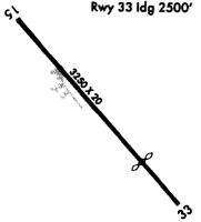
| Runways: | 15/33 |
| Longest Runway: | 15/33 is 3100 ft (945 m) long |
| Runways with an Instrument Approach: |
20N Airport Runway Details
| Runway 15/33 | 3100 ft x 60 ft (945 m x 18 m) | |
| Runway Length Source: | 3RD PARTY SURVEY as of 10/18/2011 | |
| Surface: | Asphalt - Good condition - No special surface treatment | |
| Runway Edge Lights: | Medium Intensity | |
Runway Weight Bearing Capacity (in thousands of pounds) |
||
| Single Wheel Landing Gear: | 12.5 | |
Runway 15 |
Runway 33 |
|
Elevation: |
147.3 | 133.4 |
Latitude: |
41-59-18.6462N | 41-58-55.1442N |
Longitude: |
073-58-04.7115W | 073-57-38.3961W |
|
Runway True Alignment: |
140 | 320 |
Glide Path Angle: |
4.5 degrees | 3.6 degrees |
Traffic Pattern: |
Left | Left |
Runway Markings Type: |
Nonprecision Instrument | Nonprecision Instrument |
Runway Markings Condition: |
Good | Good |
Object at End: |
TREE | BLDG |
Object Height: |
39 | 43 |
Distance from End: |
271 | 373 |
Object Centerline Offset: |
58 ft. right of centerline | 20 ft. left of centerline |
Visual Glide Slope Indicators: |
2-Light PAPI On Left Side Of Runway | 2-Light PAPI On Left Side Of Runway |
REIL: |
No | Yes |
Threshold Crossing Height: |
50 | 53 |
Threshold Elevation: |
147.3 | 135.6 |
Displaced Threshold: |
235 | 309 |
Threshold Latitude: |
41-59-16.8679N | 41-58-57.4868N |
Threshold Longitude: |
073-58-02.7196W | 073-57-41.0160W |
Declared Distances |
||
Take Off Run Avbl. (TORA): |
3100 | 3100 |
Take Off Distance Avbl. (TODA): |
3100 | 3100 |
Actual Stop Dist. Avbl. (ASDA): |
3010 | 2939 |
Landing Dist. Avbl. (LDA): |
2775 | 2630 |
Services
Airframe Repair: |
Major |
Powerplant Repair: |
Major |
Bottled Oxygen: |
None |
Bulk Oxygen: |
None |
Fuel Available: |
100LL |
Landing Fees: |
No |
Parking: |
Tiedowns available |
Maps & Diagrams
20N Sectional
Flight Planning
at skyvector.com
at skyvector.com