Location
Latitude: |
42-44-56.8180N (42.749116) |
Longitude: |
073-48-07.1280W (-73.80198) |
Elevation: |
284.8 feet MSL (87 m MSL) |
Magnetic Variation: |
13.1 W (as of April 2024 from WMM2020 model) |
Time Zone: |
UTC -5.0 (Standard Time) UTC -4.0 (Daylight Savings Time) |
From City: |
06 N.M. NW of Albany, New York |
Found On: |
New York Chart |
FAA Region: |
AEA |
Contacts
Manager: |
Publicly owned: |
| TODD PENNINGTON 737 ALBANY SHAKER ROAD ALBANY, NY 12211 518-242-2352 |
ALBANY COUNTY ARPT AUTH 737 ALBANY SHAKER ROAD ALBANY, NY 12211 518-242-2200 |
Operations
Airport Status: |
Operational |
Facility Use: |
Public |
Type: |
Airport |
Activation Date: |
03/1941 |
Control tower: |
Yes |
Attendance (Months/Days/Hours): |
Months/Days/Hours ALL/ALL/ALL |
Boundary ARTCC: |
ZBW (Boston) |
Responsible ARTCC: |
ZBW (Boston) |
Lighting Schedule: |
SS-SR |
Segmented Circle Indicator: |
No |
Traffic Pattern Altitude (MSL): |
1285 feet (392 m) |
NOTAMs Facility: |
ALB |
NOTAM-D Service: |
Yes |
International Airport of Entry: |
Yes |
Customs Landing Rights: |
No |
Military Landing Rights: |
Yes |
Civil/Military Joint Use: |
No |
Aircraft Rescue and Firefighting: |
Class I ARFF Index: C Air Carrier Service: Scheduled Certification Date: 05/1973 |
Based Aircraft
| Single Engine: | 57 |
| Multi Engine: | 7 |
| Jet Engine: | 5 |
| GA Helicopters: | 11 |
| Military Aircraft: | 11 |
Annual Operations (as of 01/01/2023)
| Total Operations: | 53799 | |
| Commercial: | 26287 | 48.9% |
| Air Taxi: | 10619 | 19.7% |
| GA Local: | 8009 | 14.9% |
| GA Itinerant: | 6421 | 11.9% |
| Military Aircraft: | 2463 | 4.6% |
Communications
| Unicom: | 122.950 |
| Tower: | ALBANY 119.5 257.8 Hrs: 24 |
| Clearance Del.: | 127.5 |
| Ground: | 121.7 348.6 |
| Approach: | ALBANY 118.05 ;194-011 132.825 ;011-194 263.075 ;194-011 307.2 ;011-194 Hrs: 24 118.05 127.15 |
| Departure: | ALBANY 118.05 ;194-011 132.825 ;011-194 263.075 ;194-011 307.2 ;011-194 Hrs: 24 118.05 127.15 |
| ATIS: | 120.45 Hrs: 24 |
| ASOS: | 120.45 (518-464-6423) |
| CLASS C: | 118.05 ;194-011 |
| CLASS C: | 307.2 ;011-194 |
| CLASS C: | 132.825 ;011-194 |
| EMERG: | 243.0 |
| EMERG: | 121.5 |
| NG OPS: | 258.2 |
| NG OPS: | 122.775 |
| CLASS C: | 263.075 ;194-011 |
| NG OPS: | 30.1FM |
Fixed Based Operators (FBOs) & Fuel
(Click on a business for detail)
Please help us keep this information up to date. This is a FREE SERVICE just like everything else on Airport Guide! If you see that a business needs to be added, modified, or deleted please fill out our Update Form.
To add, modify, or delete a business click here.
Please help us keep this information up to date. This is a FREE SERVICE just like everything else on Airport Guide! If you see that a business needs to be added, modified, or deleted please fill out our Update Form.
Area Code: 518 |
| Business Name | Frequency | Phone | Fuel Grade |
|---|---|---|---|
| Signature Flight Support
Website Update FBO info |
Unicom 122.95, Arinc 129.7 | 869-0253 | 100LL, Jet A |
Flight Service Stations
| Primary | Alternate | |
| FSS on Field: | ||
| FSS Name (ID): | Burlington(BTV) | |
| Frequency: | ||
| Toll Free Phone: | 1-800-WX-BRIEF |
Instrument Procedures / Charts
FAA Terminal Procedures valid from 0901Z 03/21/24 to 0901Z 04/18/24.
There are various types of charts available for an airport. They are listed in the Page Type column. Here is a legend for those types:
APD - Airport Diagram
DP - Departure Procedure Charts
HOT - Hot Spots
IAP - Instrument Approach Procedure Charts
MIN - Minimums
STAR - Standard Terminal Arrival Charts
| Page Type | Page Name | Volume | Action Since Last Cycle |
|---|---|---|---|
| APD | AIRPORT DIAGRAM | NE-2 | |
| DP | ALBANY SEVEN | NE-2 | |
| DP | ALBANY SEVEN[DELIMITER] CONT.1 | NE-2 | |
| IAP | ILS OR LOC RWY 01 | NE-2 | |
| IAP | ILS OR LOC RWY 19 | NE-2 | |
| IAP | ILS RWY 01 (SA CAT II) | NE-2 | |
| IAP | RNAV (GPS) RWY 10 | NE-2 | |
| IAP | RNAV (GPS) RWY 28 | NE-2 | |
| IAP | RNAV (GPS) Y RWY 01 | NE-2 | |
| IAP | RNAV (GPS) Y RWY 19 | NE-2 | |
| IAP | RNAV (RNP) Z RWY 01 | NE-2 | |
| IAP | RNAV (RNP) Z RWY 19 | NE-2 | |
| IAP | VOR RWY 28 | NE-2 | |
| LAH | LAHSO | NE-2 | |
| MIN | ALTERNATE MINIMUMS | NE-2 | |
| MIN | TAKEOFF MINIMUMS | NE-2 |
Terminal Procedures are only available for airports in several countries with more being added all the time. If you are looking for a specific country's charts, please send an email to support(at)airportguide.com stating the country name. This will be used to prioritize the implementation.
Navigation Aids (Navaids) near ALB
| Dist (NM) | ID | Morse Code | Name | Type | Freq | True Hdg | Mag Hdg |
|---|---|---|---|---|---|---|---|
| 0.1 | ALB | . _ . _ . . _ . . . | Albany | VORTAC | 115.30 | 206 | 219 |
| 1.0 | ALB | . _ . _ . . _ . . . | Albany | VOT | 108.20 | 245 | 258 |
| 8.6 | HEU | . . . . . . . _ | Hunter | NDB | 356 | 317 | 330 |
| 24.9 | CAM | _ . _ . . _ _ _ | Cambridge | VOR-DME | 115.00 | 53 | 66 |
| 27.7 | JJH | . _ _ _ . _ _ _ . . . . | Johnstown | NDB | 523 | 303 | 316 |
| 30.0 | PFH | . _ _ . . . _ . . . . . | Philmont | NDB | 272 | 173 | 186 |
| 31.6 | GF | _ _ . . . _ . | Ganse | NDB | 209 | 15 | 28 |
| 36.5 | GFL | _ _ . . . _ . . _ . . | Glens Falls | VORTAC | 110.20 | 13 | 26 |
| 38.3 | GBR | _ _ . _ . . . . _ . | Great Barrington | NDB | 395 | 152 | 165 |
| 42.6 | VWD | . . . _ . _ _ _ . . | Mount Snow | NDB | 224 | 75 | 88 |
| 46.6 | CTR | _ . _ . _ . _ . | Chester | VOR-DME | 115.10 | 125 | 138 |
| 53.2 | OZ | _ _ _ _ _ . . | Kring | NDB | 279 | 259 | 272 |
| 59.4 | PWL | . _ _ . . _ _ . _ . . | Pawling | VOR-DME | 114.30 | 171 | 184 |
| 59.6 | BAF | _ . . . . _ . . _ . | Barnes | VORTAC | 113.00 | 125 | 138 |
| 59.7 | RUT | . _ . . . _ _ | Rutland | DME | 111 | 38 | 51 |
| 61.5 | DNY | _ . . _ . _ . _ _ | Delancey | VOR-DME | 112.10 | 236 | 249 |
| 61.8 | SXD | . . . _ . . _ _ . . | Springfield | NDB | 265 | 59 | 72 |
| 62.2 | UCA | . . _ _ . _ . . _ | Utica | TACAN | 111.20 | 285 | 298 |
| 64.9 | R | . _ . | Chitt | FAN MARKER | 34 | 47 | |
| 65.0 | IGN | . . _ _ . _ . | Kingston | VOR-DME | 117.60 | 180 | 193 |
Nearby Airports with Fuel
Notices to Airmen (NOTAMS)
Remarks
| A11 | LEASEE. PROPERTY OWNED BY ALBANY COUNTY, 112 STATE ST., ALBANY, NY 12207; TELEPHONE 518-447-7000. |
| A110-10 | MOWING W/I SAFETY AREAS OF ALL RYS & TWYS MAY THRU NOV. |
| A110-11 | NO ACFT PARKING BETWEEN FIRE STATION AND TWY L. |
| A110-3 | TWY D EAST OF RY 01/19 IS RESTRD TO ACFT 12500 LBS & LESS. |
| A110-6 | BIRDS, DEER & OTHER WILDLIFE ON & INVOF ARPT. |
| A110-7 | WEATHER BALLOON LAUNCHES APRXLY 3 MI SOUTH OF ARPT AT 0600 & 1800. |
| A110-8 | TWY 'C' W OF TWY 'A' NON MOVEMENT AREA. |
| A110-9 | CUSTOMS/IMMIGRATION FLIGHT INFO SERVICE FACILITY LCTD NORTH END GENERAL AVIATION APRON. ACFT CLEARING CUSTOMS UTILIZE PAINTED POSITION MKGS & PROCEED TO MINIMIZE BLAST IMPACT. |
| A57-10 | A 057 RWY 28 APCH RATIO 26:1 TO DTHR. |
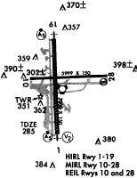
Runways
Runway Summary
| Runways: | 01/19 10/28 |
| Longest Runway: | 01/19 is 8500 ft (2591 m) long |
| Runways with an Instrument Approach: | 01, 19 |
ALB Airport Runway Details
| Runway 01/19 | 8500 ft x 150 ft (2591 m x 46 m) | |
| Runway Length Source: | 3RD PARTY SURVEY as of 09/05/2019 | |
| Surface: | Asphalt - Good condition - Saw-cut or plastic grooved | |
| Runway Pavement Class: | 70 /F/C/X/T | |
| Runway Edge Lights: | High Intensity | |
Runway Weight Bearing Capacity (in thousands of pounds) |
||
| Single Wheel Landing Gear: | 140.0 | |
| Dual Wheel Landing Gear: | 200.0 | |
| Dual Tandem Wheel Landing Gear: | 400.0 | |
Runway 01 |
Runway 19 |
|
Elevation: |
284.3 | 279.4 |
Latitude: |
42-44-13.7980N | 42-45-37.7134N |
Longitude: |
073-48-15.3251W | 073-48-18.9548W |
|
Runway True Alignment: |
358 | 178 |
ILS Type: |
ILS/DME | ILS/DME |
Glide Path Angle: |
3.0 degrees | 3.0 degrees |
Traffic Pattern: |
Left | Left |
Runway Markings Type: |
Precision Instrument | Precision Instrument |
Runway Markings Condition: |
Good | Good |
Object at End: |
TREE | |
Object Height: |
80 | |
Distance from End: |
2040 | |
Object Centerline Offset: |
75 ft. left of centerline | |
Visual Glide Slope Indicators: |
4-Light PAPI On Right Side Of Runway | 4-Light PAPI On Left Side Of Runway |
Runway Visual Range (RVR): |
Touchdown, Rollout | Touchdown, Rollout |
Approach Light System: |
1,400 Foot Medium Intensity Approach Lighting System With Runway Alignment Indicator Lights | 1,400 Foot Medium Intensity Approach Lighting System With Runway Alignment Indicator Lights |
REIL: |
No | |
Touchdown Lights: |
Yes | No |
Centerline Lights: |
Yes | Yes |
Threshold Crossing Height: |
53 | 53 |
Declared Distances |
||
Take Off Run Avbl. (TORA): |
8500 | 8500 |
Take Off Distance Avbl. (TODA): |
8500 | 8500 |
Actual Stop Dist. Avbl. (ASDA): |
8500 | 8500 |
Landing Dist. Avbl. (LDA): |
8500 | 8500 |
| Runway 10/28 | 7200 ft x 150 ft (2195 m x 46 m) | |
| Runway Length Source: | 3RD PARTY SURVEY as of 09/05/2019 | |
| Surface: | Asphalt - Good condition - Saw-cut or plastic grooved | |
| Runway Pavement Class: | 67 /F/C/X/T | |
| Runway Edge Lights: | Medium Intensity | |
Runway Weight Bearing Capacity (in thousands of pounds) |
||
| Single Wheel Landing Gear: | 140.0 | |
| Dual Wheel Landing Gear: | 200.0 | |
| Dual Tandem Wheel Landing Gear: | 400.0 | |
Runway 10 |
Runway 28 |
|
Elevation: |
276.4 | 276.0 |
Latitude: |
42-44-56.9414N | 42-44-59.1967N |
Longitude: |
073-48-43.5290W | 073-47-07.0856W |
|
Runway True Alignment: |
088 | 268 |
Glide Path Angle: |
0.0 degrees | 3.2 degrees |
Traffic Pattern: |
Left | Left |
Runway Markings Type: |
Nonprecision Instrument | Nonprecision Instrument |
Runway Markings Condition: |
Good | Good |
Object at End: |
GND | TREE |
Object Height: |
151 | 54 |
Distance from End: |
5009 | 1019 |
Object Centerline Offset: |
75 ft. left of centerline | |
Visual Glide Slope Indicators: |
4-Light PAPI On Left Side Of Runway | |
REIL: |
Yes | Yes |
Centerline Lights: |
Yes | Yes |
Threshold Crossing Height: |
53 | |
Threshold Elevation: |
277.2 | |
Displaced Threshold: |
1192 | |
Threshold Latitude: |
42-44-58.8310N | |
Threshold Longitude: |
073-47-23.0528W | |
Declared Distances |
||
Take Off Run Avbl. (TORA): |
7200 | 7200 |
Take Off Distance Avbl. (TODA): |
7200 | 7200 |
Actual Stop Dist. Avbl. (ASDA): |
6780 | 7200 |
Landing Dist. Avbl. (LDA): |
6780 | 6007 |
Services
Airframe Repair: |
Major |
Powerplant Repair: |
Major |
Bottled Oxygen: |
None |
Bulk Oxygen: |
None |
Fuel Available: |
100LL, Jet A |
Landing Fees: |
Yes |
Parking: |
Hangars and tiedowns available |
Maps & Diagrams
ALB Sectional
Flight Planning
at skyvector.com
at skyvector.com