Location
Latitude: |
40-30-32.3000N (40.508972) |
Longitude: |
122-17-36.2000W (-122.293389) |
Elevation: |
504.7 feet MSL (154 m MSL) |
Magnetic Variation: |
13.6 E (as of April 2024 from WMM2020 model) |
Time Zone: |
UTC -8.0 (Standard Time) UTC -7.0 (Daylight Savings Time) |
From City: |
06 N.M. SE of Redding, California |
Found On: |
Klamath Falls Chart |
FAA Region: |
AWP |
Contacts
Manager: |
Publicly owned: |
| JAMES WADLEIGH 6751 WOODRUM, 6751 WOODRUM CIRCLE SUITE 200 REDDING, CA 96002 530-224-4321 |
CITY OF REDDING AIRPORTS DIVISION, 6751 WOODRUM CIRCLE, #200 REDDING, CA 96002-6071 530-224-4321 |
Operations
Airport Status: |
Operational |
Facility Use: |
Public |
Type: |
Airport |
Activation Date: |
07/1944 |
Control tower: |
Yes |
Attendance (Months/Days/Hours): |
Months/Days/Hours ALL/ALL/ALL |
Boundary ARTCC: |
ZOA (Oakland) |
Responsible ARTCC: |
ZOA (Oakland) |
Lighting Schedule: |
SEE RMK |
Segmented Circle Indicator: |
Yes |
Traffic Pattern Altitude (MSL): |
1505 feet (459 m) |
NOTAMs Facility: |
RDD |
NOTAM-D Service: |
Yes |
International Airport of Entry: |
No |
Customs Landing Rights: |
No |
Military Landing Rights: |
Yes |
Civil/Military Joint Use: |
No |
Aircraft Rescue and Firefighting: |
Class I ARFF Index: B Air Carrier Service: Scheduled Certification Date: 05/1973 |
Based Aircraft
| Single Engine: | 175 |
| Multi Engine: | 15 |
| Jet Engine: | 31 |
| GA Helicopters: | 19 |
Annual Operations (as of 12/31/2022)
| Total Operations: | 60902 | |
| Commercial: | 1880 | 3.1% |
| Air Taxi: | 19859 | 32.6% |
| GA Local: | 21052 | 34.6% |
| GA Itinerant: | 17258 | 28.3% |
| Military Aircraft: | 853 | 1.4% |
Communications
| CTAF: | 119.800 |
| Unicom: | 122.950 |
| Tower: | REDDING 119.8 269.25 Hrs: 0630-2130 |
| Ground: | 121.7 |
| Approach: | OAKLAND ARTCC |
| Departure: | OAKLAND ARTCC |
| ATIS: | 124.1 Hrs: 24 |
| ASOS: | (530-221-7144) |
- APCH/DEP CTL SVC PRVDD BY OAKLAND ARTCC (ZOA) ON FREQS 132.2/350.3 (RED BLUFF RCAG).
- EMERG FREQ 121.5 NOT AVBL.
Fixed Based Operators (FBOs) & Fuel
(Click on a business for detail)
Please help us keep this information up to date. This is a FREE SERVICE just like everything else on Airport Guide! If you see that a business needs to be added, modified, or deleted please fill out our Update Form.
To add, modify, or delete a business click here.
Please help us keep this information up to date. This is a FREE SERVICE just like everything else on Airport Guide! If you see that a business needs to be added, modified, or deleted please fill out our Update Form.
Area Code: 530 |
| Business Name | Frequency | Phone | Fuel Grade |
|---|---|---|---|
| American Propeller Service
Update FBO info |
221-4470 | ||
| Jim & I Aviators, Inc.
Update FBO info |
221-5300 | ||
| Premier Aviation
Update FBO info |
226-8182 | ||
| Redding Aero Enterprises / Redding Jet Center
Website Update FBO info |
Unicom 122.95 | 224-2300 | 100LL, JET A |

|
TEXACO | 100LL - 2.75 USD per gallon on 9/8/01 |
Trucks |
|
|
TEXACO | Jet A - 2.60 USD per gallon on 9/8/01 |
Trucks add Prist @ $.05 + tax Jet A discounts: 100+ gallons @ $2.35 + tax 300+ gallons @ $2.20 + tax |
| Redding Aerotronics, Inc.
Update FBO info |
222-2376 | ||
| Redding Air Service
Update FBO info |
221-2851 | ||
| SunAir Express
Website Update FBO info |
122.95 | 226-0717 | 100LL, Jet A |
|
|
 Exxon |
100LL - 2.39 USD per gallon on 9/4/01 |
24 Hour Self Serve Credit Card Pumps Jet A and Avgas trucks; Avgas also available self-serve. Friendly, professional service every day! |
|
|
Exxon |
Jet A - 2.39 USD per gallon on 9/4/01 |
24 Hour Self Serve Credit Card Pumps Jet A and Avgas trucks; Avgas also available self-serve. Friendly, professional service every day! |
Flight Service Stations
| Primary | Alternate | |
| FSS on Field: | N | |
| FSS Name (ID): | Rancho Murieta(RIU) | |
| Frequency: | ||
| Toll Free Phone: | 1-800-WX-BRIEF |
Instrument Procedures / Charts
FAA Terminal Procedures valid from 0901Z 03/21/24 to 0901Z 04/18/24.
There are various types of charts available for an airport. They are listed in the Page Type column. Here is a legend for those types:
APD - Airport Diagram
DP - Departure Procedure Charts
HOT - Hot Spots
IAP - Instrument Approach Procedure Charts
MIN - Minimums
STAR - Standard Terminal Arrival Charts
| Page Type | Page Name | Volume | Action Since Last Cycle |
|---|---|---|---|
| APD | AIRPORT DIAGRAM | SW-2 | |
| DP | HOMAN THREE | SW-2 | |
| DP | KENDL FOUR | SW-2 | |
| DP | KREST THREE | SW-2 | |
| DP | SHASTA FOUR | SW-2 | |
| IAP | ILS OR LOC RWY 34 | SW-2 | |
| IAP | LOC BC RWY 16 | SW-2 | |
| IAP | RNAV (GPS) RWY 16 | SW-2 | |
| IAP | RNAV (GPS) RWY 34 | SW-2 | |
| IAP | VOR RWY 34 | SW-2 | |
| MIN | ALTERNATE MINIMUMS | SW-2 | |
| MIN | TAKEOFF MINIMUMS | SW-2 |
Terminal Procedures are only available for airports in several countries with more being added all the time. If you are looking for a specific country's charts, please send an email to support(at)airportguide.com stating the country name. This will be used to prioritize the implementation.
Navigation Aids (Navaids) near RDD
| Dist (NM) | ID | Morse Code | Name | Type | Freq | True Hdg | Mag Hdg |
|---|---|---|---|---|---|---|---|
| 0.3 | RDD | . _ . _ . . _ . . | Redding | VOR-DME | 114.35 | 163 | 149 |
| 23.8 | PBT | . _ _ . _ . . . _ | Proberta | NDB | 338 | 173 | 159 |
| 24.7 | RBL | . _ . _ . . . . _ . . | Red Bluff | VORTAC | 115.70 | 173 | 159 |
| 47.8 | CIC | _ . _ . . . _ . _ . | Chico | VOR-DME | 109.80 | 154 | 141 |
| 61.0 | FJS | . . _ . . _ _ _ . . . | Fort Jones | VOR-DME | 116.25 | 337 | 323 |
| 71.6 | MXW | _ _ _ . . _ . _ _ | Maxwell | VORTAC | 110.00 | 177 | 164 |
| 73.6 | MOG | _ _ _ _ _ _ _ . | Montague | NDB | 404 | 353 | 339 |
| 85.9 | UK | . . _ _ . _ | Kearn | NDB | 371 | 210 | 196 |
| 86.3 | MY | _ _ _ . _ _ | Halow | NDB | 222 | 158 | 145 |
| 87.1 | ILA | . . . _ . . . _ | Williams | VORTAC | 114.40 | 171 | 158 |
| 87.2 | ACV | . _ _ . _ . . . . _ | Arcata | VOR-DME | 115.05 | 289 | 275 |
| 89.0 | FOT | . . _ . _ _ _ _ | Fortuna | VORTAC | 114.00 | 276 | 262 |
| 90.9 | MYV | _ _ _ . _ _ . . . _ | Marysville | VOR-DME | 110.80 | 158 | 145 |
| 91.3 | BAB | _ . . . . _ _ . . . | Beale | TACAN | 108.60 | 154 | 141 |
| 98.4 | ENI | . _ . . . | Mendocino | VORTAC | 112.30 | 207 | 193 |
| 98.9 | AHC | . _ . . . . _ . _ . | Amedee | VOR-DME | 109.00 | 97 | 84 |
Nearby Airports with Fuel
Notices to Airmen (NOTAMS)
Remarks
| A110-2 | U.S. FOREST SERVICE ON FLD, EXPECT HEAVY AIR TANKER ACTIVITY DURING FIRE SEASON. |
| A110-3 | FIELD CONDITIONS RWY; APNS & TWYS GOOD TO FAIR. |
| A110-5 | FOR NOISE ABATEMENT AVOID OVERFLIGHTS OF RESIDENTIAL HOUSING WHEN POSSIBLE. |
| A110-6 | USE CTN BIRDS INVOF ARPT. |
| A110-7 | FOR CD IF UNA TO CTC ON FSS FREQ, CTC OAKLAND ARTCC AT 510-745-3380. |
| A14 | EMAIL: JWADLEIGH@CITYOFREDDING.ORG |
| A26 | PPR FOR UNSKED ACR OPNS WITH MORE THAN 30 PSGR SEATS 2130-0630 CALL AMGR (530) 224-4321. |
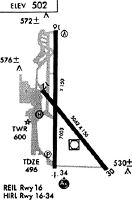
| A81-APT | ACTVT MALSR RWY 34; REIL RWY 16; PAPI RWY 16; HIRL RWY 16/34; MIRL RWY 12/30; TWY LGTS - CTAF. |
| A83 | WIND TEE & WIND CONE COLOCATED IN SEGMENTED CIRCLE. |
Runways
Runway Summary
| Runways: | 12/30 16/34 |
| Longest Runway: | 16/34 is 7003 ft (2135 m) long |
| Runways with an Instrument Approach: | 34 |
RDD Airport Runway Details
| Runway 12/30 | 5067 ft x 150 ft (1544 m x 46 m) | |
| Runway Length Source: | 3RD PARTY SURVEY as of 08/22/2014 | |
| Surface: | Asphalt - Good condition - No special surface treatment | |
| Runway Pavement Class: | 60 /F/C/X/T | |
| Runway Edge Lights: | Medium Intensity | |
Runway Weight Bearing Capacity (in thousands of pounds) |
||
| Single Wheel Landing Gear: | 60.0 | |
| Dual Wheel Landing Gear: | 72.0 | |
| Dual Tandem Wheel Landing Gear: | 110.0 | |
Runway 12 |
Runway 30 |
|
Elevation: |
499.7 | 492.0 |
Latitude: |
40-30-42.8972N | 40-30-04.4920N |
Longitude: |
122-17-49.8408W | 122-17-07.7613W |
|
Runway True Alignment: |
140 | 320 |
Glide Path Angle: |
0.0 degrees | 3.0 degrees |
Traffic Pattern: |
Left | Left |
Runway Markings Type: |
Basic | Basic |
Runway Markings Condition: |
Good | Good |
Object at End: |
TREES | TREE |
Object Height: |
65 | 88 |
Distance from End: |
1600 | 2075 |
Object Centerline Offset: |
300 ft. right of centerline | 275 ft. right of centerline |
Visual Glide Slope Indicators: |
2-Light PAPI On Left Side Of Runway | |
REIL: |
No | No |
Touchdown Lights: |
No | No |
Centerline Lights: |
No | No |
Threshold Crossing Height: |
32 | |
Declared Distances |
||
Take Off Run Avbl. (TORA): |
5067 | 5067 |
Take Off Distance Avbl. (TODA): |
5067 | 5067 |
Actual Stop Dist. Avbl. (ASDA): |
5067 | 5067 |
Landing Dist. Avbl. (LDA): |
5067 | 5067 |
| Runway 16/34 | 7003 ft x 150 ft (2135 m x 46 m) | |
| Runway Length Source: | 3RD PARTY SURVEY as of 08/22/2014 | |
| Surface: | Asphalt - Good condition - Saw-cut or plastic grooved | |
| Runway Pavement Class: | 60 /F/C/X/T | |
| Runway Edge Lights: | High Intensity | |
Runway Weight Bearing Capacity (in thousands of pounds) |
||
| Single Wheel Landing Gear: | 98.0 | |
| Dual Wheel Landing Gear: | 128.0 | |
| Dual Tandem Wheel Landing Gear: | 195.0 | |
Runway 16 |
Runway 34 |
|
Elevation: |
504.6 | 490.4 |
Latitude: |
40-31-13.2081N | 40-30-04.0054N |
Longitude: |
122-17-41.4756W | 122-17-41.5918W |
|
Runway True Alignment: |
180 | 000 |
ILS Type: |
ILS/DME | |
Glide Path Angle: |
3.4 degrees | 3.0 degrees |
Traffic Pattern: |
Left | Left |
Runway Markings Type: |
Precision Instrument | Precision Instrument |
Runway Markings Condition: |
Good | Good |
Object at End: |
TREE | |
Object Height: |
44 | |
Distance from End: |
1700 | |
Object Centerline Offset: |
300 ft. right of centerline | 275 ft. right of centerline |
Visual Glide Slope Indicators: |
4-Light PAPI On Left Side Of Runway | 4-Light PAPI On Left Side Of Runway |
Approach Light System: |
1,400 Foot Medium Intensity Approach Lighting System With Runway Alignment Indicator Lights | |
REIL: |
Yes | No |
Touchdown Lights: |
No | No |
Centerline Lights: |
No | No |
Threshold Crossing Height: |
40 | 55 |
Declared Distances |
||
Take Off Run Avbl. (TORA): |
7003 | 7003 |
Take Off Distance Avbl. (TODA): |
7003 | 7003 |
Actual Stop Dist. Avbl. (ASDA): |
7003 | 7003 |
Landing Dist. Avbl. (LDA): |
7003 | 7003 |
Services
Airframe Repair: |
Major |
Powerplant Repair: |
Major |
Bottled Oxygen: |
None |
Bulk Oxygen: |
None |
Fuel Available: |
100LL, Jet A |
Landing Fees: |
No |
Parking: |
Tiedowns available |
Maps & Diagrams
RDD Sectional
Flight Planning
at skyvector.com
at skyvector.com