Location
Latitude: |
41-38-23.2000N (41.639778) |
Longitude: |
091-32-53.3000W (-91.548139) |
Elevation: |
683.7 feet MSL (208 m MSL) |
Magnetic Variation: |
1.2 W (as of May 2024 from WMM2020 model) |
Time Zone: |
UTC -6.0 (Standard Time) UTC -5.0 (Daylight Savings Time) |
From City: |
02 N.M. SW of Iowa City, Iowa |
Found On: |
Chicago Chart |
FAA Region: |
ACE |
Contacts
Manager: |
Publicly owned: |
| MICHAEL THARP 1801 S. RIVERSIDE IOWA CITY, IA 52246 319-356-5045 |
CITY OF IOWA CITY 410 EAST WASHINGTON IOWA CITY, IA 52240 319-356-5010 |
Operations
Airport Status: |
Operational |
Facility Use: |
Public |
Type: |
Airport |
Activation Date: |
04/1946 |
Control tower: |
No |
Attendance (Months/Days/Hours): |
Months/Days/Hours ALL/ALL/0630-2030 |
Boundary ARTCC: |
ZAU (Chicago) |
Responsible ARTCC: |
ZAU (Chicago) |
Lighting Schedule: |
SEE RMK |
Segmented Circle Indicator: |
Yes |
Traffic Pattern Altitude (MSL): |
1684 feet (513 m) |
NOTAMs Facility: |
IOW |
NOTAM-D Service: |
Yes |
International Airport of Entry: |
No |
Customs Landing Rights: |
No |
Military Landing Rights: |
Yes |
Civil/Military Joint Use: |
No |
Based Aircraft
| Single Engine: | 64 |
| Multi Engine: | 1 |
| Jet Engine: | 6 |
| GA Helicopters: | 2 |
| Gliders: | 3 |
Annual Operations (as of 05/27/2022)
| Total Operations: | 33300 | |
| Air Taxi: | 3798 | 11.4% |
| GA Local: | 6388 | 19.2% |
| GA Itinerant: | 22618 | 67.9% |
| Military Aircraft: | 496 | 1.5% |
Communications
| CTAF: | 122.800 |
| Unicom: | 122.800 |
| Clearance Del.: | 119.05 119.05 119.05 119.05 |
| Approach: | CEDAR RAPIDS CHICAGO ARTCC |
| Departure: | CEDAR RAPIDS CHICAGO ARTCC |
| ASOS: | 128.075 (319-339-9491) |
- APCH/DEP SVC PRVDD BY CHICAGO ARTCC ON FREQS 132.8/328.4 (CEDAR RAPIDS RCAG) WHEN CEDAR RAPIDS APCH CTL CLSD.
Fixed Based Operators (FBOs) & Fuel
(Click on a business for detail)
Please help us keep this information up to date. This is a FREE SERVICE just like everything else on Airport Guide! If you see that a business needs to be added, modified, or deleted please fill out our Update Form.
To add, modify, or delete a business click here.
Please help us keep this information up to date. This is a FREE SERVICE just like everything else on Airport Guide! If you see that a business needs to be added, modified, or deleted please fill out our Update Form.
Area Code: 319 |
| Business Name | Frequency | Phone | Fuel Grade |
|---|---|---|---|
| Jet Air Inc.
Update FBO info |
Unicom 122.8 | 1-800-4-JET AIR | 100LL, Jet A |
Flight Service Stations
| Primary | Alternate | |
| FSS on Field: | N | |
| FSS Name (ID): | Fort Dodge(FOD) | |
| Frequency: | ||
| Toll Free Phone: | 1-800-WX-BRIEF |
Instrument Procedures / Charts
FAA Terminal Procedures valid from 0901Z 03/21/24 to 0901Z 04/18/24.
There are various types of charts available for an airport. They are listed in the Page Type column. Here is a legend for those types:
APD - Airport Diagram
DP - Departure Procedure Charts
HOT - Hot Spots
IAP - Instrument Approach Procedure Charts
MIN - Minimums
STAR - Standard Terminal Arrival Charts
| Page Type | Page Name | Volume | Action Since Last Cycle |
|---|---|---|---|
| IAP | RNAV (GPS) RWY 25 | NC-3 | |
| IAP | RNAV (GPS) RWY 30 | NC-3 | |
| IAP | VOR-A | NC-3 | |
| MIN | ALTERNATE MINIMUMS | NC-3 | |
| MIN | TAKEOFF MINIMUMS | NC-3 |
Terminal Procedures are only available for airports in several countries with more being added all the time. If you are looking for a specific country's charts, please send an email to support(at)airportguide.com stating the country name. This will be used to prioritize the implementation.
Navigation Aids (Navaids) near IOW
| Dist (NM) | ID | Morse Code | Name | Type | Freq | True Hdg | Mag Hdg |
|---|---|---|---|---|---|---|---|
| 7.8 | IOW | . . _ _ _ . _ _ | Iowa City | VOR-DME | 116.20 | 201 | 202 |
| 18.3 | CID | _ . _ . . . _ . . | Cedar Rapids | VOR-DME | 114.10 | 324 | 325 |
| 22.3 | AWG | . _ . _ _ _ _ . | Washington | NDB | 219 | 194 | 195 |
| 24.3 | DDD | _ . . _ . . _ . . | Port City | DME | 116.5 | 132 | 133 |
| 41.5 | MPZ | _ _ . _ _ . _ _ . . | Mount Pleasant | NDB | 212 | 177 | 178 |
| 42.6 | FFL | . . _ . . . _ . . _ . . | Fairfield | NDB | 332 | 207 | 208 |
| 43.2 | DVN | _ . . . . . _ _ . | Davenport Municipal | VOT | 111.80 | 91 | 93 |
| 45.2 | MZV | _ _ _ _ . . . . . _ | Moline | VOR-DME | 114.40 | 114 | 116 |
| 47.9 | CVA | _ . _ . . . . _ . _ | Davenport | VORTAC | 113.80 | 84 | 86 |
| 49.0 | OOA | _ _ _ _ _ _ . _ | Oskaloosa | NDB | 414 | 239 | 240 |
| 50.7 | OTM | _ _ _ _ _ _ | Ottumwa | VOR-DME | 111.60 | 223 | 224 |
| 52.0 | IIB | . . . . _ . . . | Wapsie | NDB | 206 | 339 | 340 |
| 52.3 | FN | . . _ . _ . | Hillz | NDB | 517 | 82 | 84 |
| 58.9 | DB | _ . . _ . . . | Zilom | NDB | 341 | 45 | 47 |
| 59.1 | DBQ | _ . . _ . . . _ _ . _ | Dubuque | VORTAC | 115.80 | 39 | 41 |
| 61.7 | BRL | _ . . . . _ . . _ . . | Burlington | VOR-DME | 111.40 | 152 | 153 |
| 62.2 | BR | _ . . . . _ . | Burns | NDB | 390 | 161 | 162 |
| 64.3 | PEA | . _ _ . . . _ | Pella | NDB | 257 | 257 | 258 |
| 65.6 | GBG | _ _ . _ . . . _ _ . | Galesburg | DME | 109.8 | 129 | 131 |
| 66.8 | ALO | . _ . _ . . _ _ _ | Waterloo | VOR-DME | 112.20 | 325 | 326 |
Nearby Airports with Fuel
Notices to Airmen (NOTAMS)
Remarks
| A110-1 | NOISE ABATEMENT PROCEDURES IN EFFECT, CTC ARPT MGR 319-356-5045. |
| A110-10 | RY 25 DESIGNATED AS CALM WIND RY. |
| A110-5 | WATERFOWL & DEER ON & INVOF ARPT. |
| A110-6 | HEL ACTIVITY 3/4 MILE N OF ARPT INVOF UNIVERSITY OF IOWA HOSPITAL. |
| A110-7 | NUMEROUS UNLGTD CRANES 200 FT AGL 2 NM RDS OF ARPT. |
| A110-8 | GLIDER ACTIVITY ON & INVOF ARPT. |
| A110-9 | STADIUM WITHIN 3NM, CHECK FOR EVENTS. |
| A57-25 | RY 25 APCH SLOPE 23:1 TO DSPLCD THLD. |
| A81-APT | MIRL RWY 07/25 & 12/30 PRESET LOW INTST; TO INCR INTST & ACTVT PAPI RWY 07 & 25; REIL RWY 07 & 25 - CTAF. |
| A96 | ULTRALIGHT ACTIVITY DISCOURAGED-RDO RQRD. |
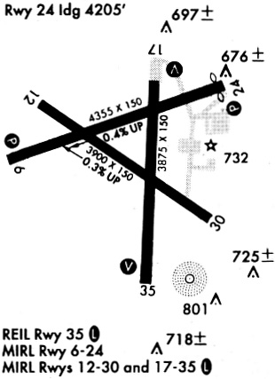
Runways
Runway Summary
| Runways: | 07/25 12/30 |
| Longest Runway: | 07/25 is 5002 ft (1525 m) long |
| Runways with an Instrument Approach: |
IOW Airport Runway Details
| Runway 07/25 | 5002 ft x 100 ft (1525 m x 30 m) | |
| Runway Length Source: | 3RD PARTY SURVEY as of 10/19/2022 | |
| Surface: | Concrete - Good condition - Saw-cut or plastic grooved | |
| Runway Pavement Class: | 15 /R/C/W/T | |
| Runway Edge Lights: | Medium Intensity | |
Runway Weight Bearing Capacity (in thousands of pounds) |
||
| Single Wheel Landing Gear: | 25.0 | |
| Dual Wheel Landing Gear: | 45.0 | |
Runway 07 |
Runway 25 |
|
Elevation: |
683.7 | 650.5 |
Latitude: |
41-38-17.6001N | 41-38-33.8184N |
Longitude: |
091-33-28.0065W | 091-32-25.7869W |
|
Runway True Alignment: |
071 | 251 |
Glide Path Angle: |
3.5 degrees | 3.0 degrees |
Traffic Pattern: |
Right | Left |
Runway Markings Type: |
Nonprecision Instrument | Nonprecision Instrument |
Runway Markings Condition: |
Fair | Fair |
Object at End: |
POLE | TREE |
Object Height: |
88 | 46 |
Distance from End: |
2079 | 950 |
Object Centerline Offset: |
263 ft. right of centerline | 50 ft. left of centerline |
Visual Glide Slope Indicators: |
4-Light PAPI On Left Side Of Runway | 4-Light PAPI On Left Side Of Runway |
REIL: |
Yes | Yes |
Threshold Crossing Height: |
51 | 38 |
Threshold Elevation: |
650.5 | |
Displaced Threshold: |
130 | |
Threshold Latitude: |
41-38-33.3961N | |
Threshold Longitude: |
091-32-27.4051W | |
Declared Distances |
||
Take Off Run Avbl. (TORA): |
5002 | 5002 |
Take Off Distance Avbl. (TODA): |
5152 | 5002 |
Actual Stop Dist. Avbl. (ASDA): |
5002 | 5002 |
Landing Dist. Avbl. (LDA): |
5002 | 4872 |
| Runway 12/30 | 3900 ft x 75 ft (1189 m x 23 m) | |
| Runway Length Source: | 3RD PARTY SURVEY as of 10/19/2022 | |
| Surface: | Concrete - Good condition - Saw-cut or plastic grooved | |
| Runway Pavement Class: | 6 /R/C/W/T | |
| Runway Edge Lights: | Medium Intensity | |
Runway Weight Bearing Capacity (in thousands of pounds) |
||
| Single Wheel Landing Gear: | 15.0 | |
| Dual Wheel Landing Gear: | 20.0 | |
Runway 12 |
Runway 30 |
|
Elevation: |
661.3 | 648.7 |
Latitude: |
41-38-30.8616N | 41-38-08.9450N |
Longitude: |
091-33-09.7982W | 091-32-27.5526W |
|
Runway True Alignment: |
125 | 305 |
Glide Path Angle: |
0.0 degrees | 0.0 degrees |
Traffic Pattern: |
Right | Left |
Runway Markings Type: |
Nonprecision Instrument | Nonprecision Instrument |
Runway Markings Condition: |
Fair | Fair |
Object at End: |
TREE | TREE |
Object Height: |
85 | 84 |
Distance from End: |
1454 | 1327 |
Object Centerline Offset: |
263 ft. right of centerline | 50 ft. left of centerline |
Services
Airframe Repair: |
None |
Powerplant Repair: |
None |
Bottled Oxygen: |
None |
Bulk Oxygen: |
None |
Fuel Available: |
100LL |
Landing Fees: |
No |
Parking: |
Hangars and tiedowns available |
Maps & Diagrams
IOW Sectional
Flight Planning
at skyvector.com
at skyvector.com