Location
Latitude: |
36-51-19.0000N (36.855278) |
Longitude: |
084-51-22.1000W (-84.856139) |
Elevation: |
962.6 feet MSL (293 m MSL) |
Magnetic Variation: |
5.5 W (as of April 2024 from WMM2020 model) |
Time Zone: |
UTC -5.0 (Standard Time) UTC -4.0 (Daylight Savings Time) |
From City: |
02 N.M. N of Monticello, Kentucky |
Found On: |
Cincinnati Chart |
FAA Region: |
ASO |
Contacts
Manager: |
Publicly owned: |
| JERRY HAMPTON 519 AIRPORT ROAD MONTICELLO, KY 42633 (661) 205-6415 |
WAYNE CO ARPT BOARD P.O. BOX 439 MONTICELLO, KY 42633 606-348-4241 |
Operations
Airport Status: |
Operational |
Facility Use: |
Public |
Type: |
Airport |
Activation Date: |
10/1975 |
Control tower: |
No |
Attendance (Months/Days/Hours): |
Months/Days/Hours ALL/MON-SAT/0830-1730 |
Boundary ARTCC: |
ZID (Indianapolis) |
Responsible ARTCC: |
ZID (Indianapolis) |
Lighting Schedule: |
SEE RMK |
Segmented Circle Indicator: |
Yes |
Traffic Pattern Altitude (MSL): |
1963 feet (598 m) |
NOTAMs Facility: |
LOU |
NOTAM-D Service: |
Yes |
International Airport of Entry: |
No |
Customs Landing Rights: |
No |
Military Landing Rights: |
Yes |
Civil/Military Joint Use: |
No |
Based Aircraft
| Single Engine: | 9 |
| Multi Engine: | 1 |
Annual Operations (as of 04/13/2021)
| Total Operations: | 8640 | |
| Air Taxi: | 760 | 8.8% |
| GA Local: | 2900 | 33.6% |
| GA Itinerant: | 4800 | 55.6% |
| Military Aircraft: | 180 | 2.1% |
Communications
| CTAF: | 122.800 |
| Unicom: | 122.800 |
| AWOS-3PT: | 118.825 (606-348-0862) |
- APCH/DEP SVC PRVDD BY INDIANAPOLIS ARTCC ON FREQS 124.625/371.925 (LONDON 2 RCAG).
Fixed Based Operators (FBOs) & Fuel
(Click on a business for detail)
Please help us keep this information up to date. This is a FREE SERVICE just like everything else on Airport Guide! If you see that a business needs to be added, modified, or deleted please fill out our Update Form.
To add, modify, or delete a business click here.
Please help us keep this information up to date. This is a FREE SERVICE just like everything else on Airport Guide! If you see that a business needs to be added, modified, or deleted please fill out our Update Form.
Area Code: 606 |
| Business Name | Frequency | Phone | Fuel Grade |
|---|
Flight Service Stations
| Primary | Alternate | |
| FSS on Field: | N | |
| FSS Name (ID): | Louisville(LOU) | |
| Frequency: | ||
| Toll Free Phone: | 1-800-WX-BRIEF |
Instrument Procedures / Charts
FAA Terminal Procedures valid from 0901Z 03/21/24 to 0901Z 04/18/24.
There are various types of charts available for an airport. They are listed in the Page Type column. Here is a legend for those types:
APD - Airport Diagram
DP - Departure Procedure Charts
HOT - Hot Spots
IAP - Instrument Approach Procedure Charts
MIN - Minimums
STAR - Standard Terminal Arrival Charts
| Page Type | Page Name | Volume | Action Since Last Cycle |
|---|---|---|---|
| IAP | RNAV (GPS) RWY 03 | SE-1 | |
| IAP | RNAV (GPS) RWY 21 | SE-1 | |
| MIN | ALTERNATE MINIMUMS | SE-1 | |
| MIN | TAKEOFF MINIMUMS | SE-1 |
Terminal Procedures are only available for airports in several countries with more being added all the time. If you are looking for a specific country's charts, please send an email to support(at)airportguide.com stating the country name. This will be used to prioritize the implementation.
Navigation Aids (Navaids) near EKQ
| Dist (NM) | ID | Morse Code | Name | Type | Freq | True Hdg | Mag Hdg |
|---|---|---|---|---|---|---|---|
| 11.9 | CDX | _ . _ . _ . . _ . . _ | Cumberland River | NDB | 388 | 44 | 50 |
| 22.1 | LVT | . _ . . . . . _ _ | Livingston | VOR-DME | 114.35 | 222 | 227 |
| 26.3 | BPO | _ . . . . _ _ . _ _ _ | Piney Grove | NDB | 403 | 135 | 141 |
| 37.3 | LOZ | . _ . . _ _ _ _ _ . . | London | VOR-DME | 116.55 | 73 | 79 |
| 37.7 | TYC | _ _ . _ _ _ . _ . | Taylor County | NDB | 272 | 330 | 335 |
| 43.5 | DVK | _ . . . . . _ _ . _ | Goodall | NDB | 311 | 5 | 11 |
| 50.2 | IKY | . . _ . _ _ . _ _ | Springfield | NDB | 429 | 338 | 343 |
| 56.1 | BVQ | _ . . . . . . _ _ _ . _ | Beaver Creek | NDB | 260 | 280 | 285 |
| 60.9 | EWO | . . _ _ _ _ _ | New Hope | VOR-DME | 113.95 | 320 | 325 |
| 62.9 | HEM | . . . . . _ _ | Huchn | NDB | 233 | 214 | 219 |
| 64.7 | HCH | . . . . _ . _ . . . . . | Hinch Mountain | VOR-DME | 117.60 | 185 | 190 |
| 66.6 | BRY | _ . . . . _ . _ . _ _ | Bardstown/Dcmsnd | NDB | 248 | 333 | 338 |
| 67.0 | XYC | _ . . _ _ . _ _ _ . _ . | Seco | NDB | 393 | 35 | 41 |
| 68.5 | LE | . _ . . . | Blayd | NDB | 242 | 7 | 13 |
| 69.1 | HYK | . . . . _ . _ _ _ . _ | Lexington | VOR-DME | 112.60 | 15 | 21 |
| 69.6 | SKN | . . . _ . _ _ . | Hurricane | NDB | 256 | 221 | 226 |
| 73.5 | VXV | . . . _ _ . . _ . . . _ | Volunteer | VORTAC | 116.40 | 140 | 146 |
| 74.9 | TYS | _ _ . _ _ . . . | Knoxville | VOT | 112.00 | 146 | 152 |
| 76.3 | BWG | _ . . . . _ _ _ _ . | Bowling Green | DME | 117.9 | 273 | 278 |
| 78.0 | GN | _ _ . _ . | Bridl | NDB | 340 | 12 | 18 |
Nearby Airports with Fuel
Notices to Airmen (NOTAMS)
Remarks
| A110-1 | FOR CD CTC INDIANAPOLIS ARTCC AT 317-247-2411. |
| A13 | 606-348-4241 |
| A42-03 | FADED & ALGAE COVERED |
| A42-21 | FADED & ALGAE COVERED |
| A58-03 | FENCE 249.5 FT L PARALLEL TO RWY. |
| A70-FUEL-10 | 0LL FUEL AVBL 24/7 WITH CC. |
| A81-APT | ACTVT REIL RWY 21; PAPI RWY 03/21; MIRL RWY 03/21 - CTAF. LTG PRESET LOW INTST; INCR INTST - CTAF. |
| E111 | VFR ONLY. |
Runways
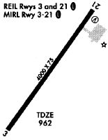
Runway Summary
| Runways: | 03/21 |
| Longest Runway: | 03/21 is 4000 ft (1219 m) long |
| Runways with an Instrument Approach: |
EKQ Airport Runway Details
| Runway 03/21 | 4000 ft x 75 ft (1219 m x 23 m) | |
| Runway Length Source: | 3RD PARTY SURVEY as of 06/15/2011 | |
| Surface: | Asphalt - Good condition - No special surface treatment | |
| Runway Edge Lights: | Medium Intensity | |
Runway Weight Bearing Capacity (in thousands of pounds) |
||
| Single Wheel Landing Gear: | 12.5 | |
Runway 03 |
Runway 21 |
|
Elevation: |
958.6 | 962.5 |
Latitude: |
36-51-02.9024N | 36-51-34.9949N |
Longitude: |
084-51-36.4322W | 084-51-07.6750W |
|
Runway True Alignment: |
036 | 216 |
Glide Path Angle: |
3.0 degrees | 3.0 degrees |
Traffic Pattern: |
Left | Left |
Runway Markings Type: |
Nonprecision Instrument | Nonprecision Instrument |
Runway Markings Condition: |
Poor | Poor |
Object at End: |
FENCE | TREE |
Object Height: |
23 | 119 |
Distance from End: |
201 | 1971 |
Object Centerline Offset: |
250 ft. left of centerline | 477 ft. right of centerline |
Visual Glide Slope Indicators: |
4-Light PAPI On Left Side Of Runway | 4-Light PAPI On Left Side Of Runway |
REIL: |
Yes | Yes |
Threshold Crossing Height: |
40 | 40 |
Services
Airframe Repair: |
Major |
Powerplant Repair: |
Major |
Fuel Available: |
100LL, Jet A |
Landing Fees: |
No |
Parking: |
Hangars and tiedowns available |
Maps & Diagrams
EKQ Sectional
Flight Planning
at skyvector.com
at skyvector.com