Location
Latitude: |
41-22-17.5240N (41.371534) |
Longitude: |
073-28-55.8820W (-73.482189) |
Elevation: |
456.7 feet MSL (139 m MSL) |
Magnetic Variation: |
13 W (as of April 2024 from WMM2020 model) |
Time Zone: |
UTC -5.0 (Standard Time) UTC -4.0 (Daylight Savings Time) |
From City: |
03 N.M. SW of Danbury, Connecticut |
Found On: |
New York Chart |
FAA Region: |
ANE |
Contacts
Manager: |
Publicly owned: |
| MICHAEL SAFRANEK P.O.BOX 2299 DANBURY, CT 06813 203-797-4624 |
CITY OF DANBURY CITY HALL, 115 DEER HILL DR. DANBURY, CT 06810 203-797-4624 |
Operations
Airport Status: |
Operational |
Facility Use: |
Public |
Type: |
Airport |
Activation Date: |
04/1940 |
Control tower: |
Yes |
Attendance (Months/Days/Hours): |
Months/Days/Hours ALL/ALL/0700-DUSK |
Boundary ARTCC: |
ZNY (New York) |
Responsible ARTCC: |
ZNY (New York) |
Lighting Schedule: |
SEE RMK |
Segmented Circle Indicator: |
Yes |
Traffic Pattern Altitude (MSL): |
1457 feet (444 m) |
NOTAMs Facility: |
DXR |
NOTAM-D Service: |
Yes |
International Airport of Entry: |
No |
Customs Landing Rights: |
No |
Military Landing Rights: |
Yes |
Civil/Military Joint Use: |
No |
Based Aircraft
| Single Engine: | 170 |
| Multi Engine: | 23 |
| Jet Engine: | 9 |
| GA Helicopters: | 9 |
Annual Operations (as of 12/31/2021)
| Total Operations: | 53524 | |
| Air Taxi: | 1750 | 3.3% |
| GA Local: | 23335 | 43.6% |
| GA Itinerant: | 28253 | 52.8% |
| Military Aircraft: | 186 | 0.3% |
Communications
| CTAF: | 119.400 |
| Unicom: | 122.950 |
| Tower: | DANBURY 119.4 Hrs: 0700-2200 |
| Ground: | 121.6 |
| Approach: | NEW YORK |
| Departure: | NEW YORK |
| ATIS: | 127.75 Hrs: 24 |
| ASOS: | 127.75 (203-791-8227) |
Fixed Based Operators (FBOs) & Fuel
(Click on a business for detail)
Please help us keep this information up to date. This is a FREE SERVICE just like everything else on Airport Guide! If you see that a business needs to be added, modified, or deleted please fill out our Update Form.
To add, modify, or delete a business click here.
Please help us keep this information up to date. This is a FREE SERVICE just like everything else on Airport Guide! If you see that a business needs to be added, modified, or deleted please fill out our Update Form.
Area Code: 203 |
| Business Name | Frequency | Phone | Fuel Grade |
|---|---|---|---|
| Arrow Aviation
Website Update FBO info |
203-744-5010 | 100LL | |
| Business Aircraft Center, Inc.
Website Update FBO info |
Unicom 122.95 | 748-7000 | 100LL, Jet A |
| Curtiss Aero
Website Update FBO info |
743-4007, 798-7565, after hours emergency call 792-2707 | 100LL | |
| Executive Air Service, Inc.
Update FBO info |
Unicom 122.95 | 778-1150 | 100LL, Jet A |
| Helicopter Services of Connecticut
Update FBO info |
778-2898 | ||
| Master Aviation, Inc.
Update FBO info |
790-5226 | ||
| New England Aircraft Sales
Update FBO info |
748-1449 | ||
| North American Aviation
Website Update FBO info |
778-4546, 743-3300 | ||
| Reliant Aircraft Service, Inc.
Update FBO info |
Unicom 122.82 | 743-5100 | 100LL, Jet A |
| Sadler Aero Center
Website Update FBO info |
798-9632 |
Flight Service Stations
| Primary | Alternate | |
| FSS on Field: | N | |
| FSS Name (ID): | Bridgeport(BDR) | |
| Frequency: | ||
| Toll Free Phone: | 1-800-WX-BRIEF |
Instrument Procedures / Charts
FAA Terminal Procedures valid from 0901Z 03/21/24 to 0901Z 04/18/24.
There are various types of charts available for an airport. They are listed in the Page Type column. Here is a legend for those types:
APD - Airport Diagram
DP - Departure Procedure Charts
HOT - Hot Spots
IAP - Instrument Approach Procedure Charts
MIN - Minimums
STAR - Standard Terminal Arrival Charts
| Page Type | Page Name | Volume | Action Since Last Cycle |
|---|---|---|---|
| APD | AIRPORT DIAGRAM | NE-1 | |
| HOT | HOT SPOT | NE-1 | |
| IAP | LOC RWY 08 | NE-1 | |
| IAP | RNAV (GPS) RWY 08 | NE-1 | |
| IAP | RNAV (GPS) RWY 26 | NE-1 | |
| IAP | RNAV (GPS) Z RWY 08 | NE-1 | |
| IAP | RNAV (GPS)-A | NE-1 | |
| MIN | ALTERNATE MINIMUMS | NE-1 | |
| MIN | TAKEOFF MINIMUMS | NE-1 | |
| STAR | NOBBI FIVE | NE-1 | |
| STAR | NOBBI FIVE[DELIMITER] CONT.1 | NE-1 | |
| STAR | RICED FOUR | NE-1 | |
| STAR | VALRE FIVE | NE-1 |
Terminal Procedures are only available for airports in several countries with more being added all the time. If you are looking for a specific country's charts, please send an email to support(at)airportguide.com stating the country name. This will be used to prioritize the implementation.
Navigation Aids (Navaids) near DXR
| Dist (NM) | ID | Morse Code | Name | Type | Freq | True Hdg | Mag Hdg |
|---|---|---|---|---|---|---|---|
| 7.1 | CMK | _ . _ . _ _ _ . _ | Carmel | VOR-DME | 116.60 | 219 | 232 |
| 16.7 | JWE | . _ _ _ . _ _ . | Clera | NDB | 362 | 87 | 100 |
| 20.4 | BDR | _ . . . _ . . . _ . | Bridgeport | VOT | 109.25 | 127 | 140 |
| 20.5 | BDR | _ . . . _ . . . _ . | Bridgeport | VOR-DME | 108.80 | 127 | 140 |
| 23.3 | IGN | . . _ _ . _ . | Kingston | VOR-DME | 117.60 | 319 | 332 |
| 24.5 | PWL | . _ _ . . _ _ . _ . . | Pawling | VOR-DME | 114.30 | 347 | 360 |
| 24.9 | PO | . _ _ . _ _ _ | Meier | NDB | 403 | 299 | 312 |
| 27.0 | SKU | . . . _ . _ . . _ | Stanwyck | NDB | 261 | 290 | 303 |
| 27.0 | SKU | . . . _ . _ . . _ | Stanwyck | FAN MARKER | 290 | 303 | |
| 27.7 | HVN | . . . . . . . _ _ . | New Haven | DME | 109.8 | 103 | 116 |
| 28.8 | OP | _ _ _ . _ _ . | Old Field Point Light | NDB | 316 | 145 | 158 |
| 34.2 | SW | . . . . _ _ | Neely | NDB | 335 | 281 | 294 |
| 35.7 | FR | . . _ . . _ . | Frikk | NDB | 407 | 180 | 193 |
| 35.7 | DPK | _ . . . _ _ . _ . _ | Deer Park | VOR-DME | 117.70 | 166 | 179 |
| 35.8 | MAD | _ _ . _ _ . . | Madison | VOR-DME | 110.40 | 95 | 108 |
| 38.9 | ISP | . . . . . . _ _ . | Long Island Mac Arthur | VOT | 109.40 | 153 | 166 |
| 39.4 | LGA | . _ . . _ _ . . _ | La Guardia | VOR-DME | 113.10 | 206 | 219 |
| 40.7 | CCC | _ . _ . _ . _ . _ . _ . | Calverton | VOR-DME | 114.55 | 130 | 143 |
| 40.8 | IS | . . . . . | Lokks | NDB | 366 | 160 | 173 |
| 40.9 | TEB | _ . _ . . . | Teterboro | VOR-DME | 108.40 | 220 | 233 |
Nearby Airports with Fuel
Notices to Airmen (NOTAMS)
Remarks
| A110-1 | ACFT USING RWY 35 ARE NOT VSB FM TWR DESCENDING BLW 1300 FT ON BASE LEG TIL APCHG 1/2 MI FINAL DUE TO NATURAL TRRN. |
| A110-10 | PROHIBITED TO ULTRALIGHT & UNREGISTERED ACFT. |
| A110-12 | COND UNMNT 1630-0730 MON-FRI & WKENDS. |
| A110-2 | DEER & BIRDS ON & INVOF ARPT. |
| A110-4 | INTXN TKOFS, STOP & GO TKOFS NOT AUZD. |
| A110-5 | PPR FOR FRMN TKOF/LDG; CTC AMGR. |
| A110-8 | NOISE ABATEMENT PROCS IN EFCT CTC AMGR 203-797-4624. |
| A30-17/35 | RWY CLSD NGTS. |
| A57-08 | APCH RATIO 12:1 BASED ON DSPLCD THR. |
| A57-17 | APCH RATIO 28:1 TO DSPLCD THR. |
| A57-26 | APCH RATIO 11:1 TO DSPLCD THR. |
| A57-35 | APCH RATIO 19:1 TO DSPLCD THR. |
| A58-08 | +9 FT FENCE 170 FT FM THR. |
| A58-17 | 5 FT FENCE 50 FT FM THR; +15 FT ROAD 94 FT FM THR. |
| A58-26 | +6 FT FENCE 75 FT FM THR. |
| A58-35 | +8 FT FENCE 150 FT FM THR; +17 FT ROAD 120 FT FM THR. |
| A80 | ROTG BCN LCTD ONE MILE SOUTH OF ARPT ON TOP OF A HILL. |
| A81-APT | WHEN ATCT CLSD, ACTVT REIL RWY 08 & 26; MIRL RWY 08/26 - CTAF. |
| E111 | EXISTED PRIOR TO 1959. |
| E147 | 1743 FT AGL TURBOPROP/JET. |
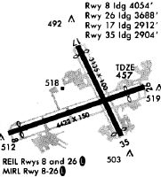
Runways
Runway Summary
| Runways: | 08/26 17/35 |
| Longest Runway: | 08/26 is 4421 ft (1348 m) long |
| Runways with an Instrument Approach: | 08 |
DXR Airport Runway Details
| Runway 08/26 | 4421 ft x 150 ft (1348 m x 46 m) | |
| Runway Length Source: | 3RD PARTY SURVEY as of 10/02/2014 | |
| Surface: | Asphalt - Good condition - Saw-cut or plastic grooved | |
| Runway Edge Lights: | Medium Intensity | |
Runway Weight Bearing Capacity (in thousands of pounds) |
||
| Single Wheel Landing Gear: | 38.0 | |
| Dual Wheel Landing Gear: | 70.0 | |
Runway 08 |
Runway 26 |
|
Elevation: |
456.6 | 453.1 |
Latitude: |
41-22-07.3123N | 41-22-22.4190N |
Longitude: |
073-29-26.7341W | 073-28-32.3252W |
|
Runway True Alignment: |
070 | 250 |
ILS Type: |
LOC/DME | |
Glide Path Angle: |
0.0 degrees | 0.0 degrees |
Traffic Pattern: |
Left | Left |
Runway Markings Type: |
Nonprecision Instrument | Nonprecision Instrument |
Runway Markings Condition: |
Good | Good |
Object at End: |
TREES | TREES |
Object Height: |
15 | 88 |
Distance from End: |
230 | 450 |
Object Centerline Offset: |
75 ft. left of centerline | 100 ft. right of centerline |
REIL: |
Yes | Yes |
Touchdown Lights: |
No | No |
Centerline Lights: |
No | No |
Threshold Elevation: |
456.6 | 453.3 |
Displaced Threshold: |
367 | 734 |
Threshold Latitude: |
41-22-08.5631N | 41-22-19.9137N |
Threshold Longitude: |
073-29-22.2222W | 073-28-41.3548W |
| Runway 17/35 | 3135 ft x 100 ft (956 m x 30 m) | |
| Runway Length Source: | 3RD PARTY SURVEY as of 10/02/2014 | |
| Surface: | Asphalt - Good condition - No special surface treatment | |
Runway Weight Bearing Capacity (in thousands of pounds) |
||
| Single Wheel Landing Gear: | 50.0 | |
| Dual Wheel Landing Gear: | 65.0 | |
Runway 17 |
Runway 35 |
|
Elevation: |
451.5 | 453.3 |
Latitude: |
41-22-35.0829N | 41-22-07.4627N |
Longitude: |
073-29-00.0393W | 073-28-41.4351W |
|
Runway True Alignment: |
153 | 333 |
Glide Path Angle: |
0.0 degrees | 0.0 degrees |
Traffic Pattern: |
Left | Left |
Runway Markings Type: |
Basic | Basic |
Runway Markings Condition: |
Good | Good |
Object at End: |
POLE | TREES |
Object Height: |
22 | 30 |
Distance from End: |
600 | 350 |
Object Centerline Offset: |
75 ft. left of centerline | 100 ft. right of centerline |
REIL: |
No | No |
Touchdown Lights: |
No | No |
Centerline Lights: |
No | No |
Threshold Elevation: |
451.9 | 453.2 |
Displaced Threshold: |
223 | 231 |
Threshold Latitude: |
41-22-33.1188N | 41-22-09.5001N |
Threshold Longitude: |
073-28-58.7228W | 073-28-42.8084W |
Services
Airframe Repair: |
Major |
Powerplant Repair: |
Major |
Bottled Oxygen: |
None |
Bulk Oxygen: |
None |
Fuel Available: |
100LL, Jet A |
Landing Fees: |
Yes |
Parking: |
Tiedowns available |
Maps & Diagrams
DXR Sectional
Flight Planning
at skyvector.com
at skyvector.com