Location
Latitude: |
41-30-42.5220N (41.511812) |
Longitude: |
074-15-48.7410W (-74.263539) |
Elevation: |
369.9 feet MSL (113 m MSL) |
Magnetic Variation: |
12.6 W (as of April 2024 from WMM2020 model) |
Time Zone: |
UTC -5.0 (Standard Time) UTC -4.0 (Daylight Savings Time) |
From City: |
01 N.M. SW of Montgomery, New York |
Found On: |
New York Chart |
FAA Region: |
AEA |
Contacts
Manager: |
Publicly owned: |
| EDWARD MAGRYTA 500 DUNN RD. MONTGOMERY, NY 12549-2402 845-457-4925 |
ORANGE COUNTY 255 MAIN STREET GOSHEN, NY 10924 845-291-4000 |
Operations
Airport Status: |
Operational |
Facility Use: |
Public |
Type: |
Airport |
Activation Date: |
07/1943 |
Control tower: |
No |
Attendance (Months/Days/Hours): |
Months/Days/Hours ALL/SUN/0830-1630 |
Boundary ARTCC: |
ZNY (New York) |
Responsible ARTCC: |
ZNY (New York) |
Lighting Schedule: |
SEE RMK |
Segmented Circle Indicator: |
Yes |
Traffic Pattern Altitude (MSL): |
1370 feet (418 m) |
NOTAMs Facility: |
MGJ |
NOTAM-D Service: |
Yes |
International Airport of Entry: |
No |
Customs Landing Rights: |
No |
Military Landing Rights: |
Yes |
Civil/Military Joint Use: |
No |
Based Aircraft
| Single Engine: | 145 |
| Multi Engine: | 15 |
| Jet Engine: | 4 |
| GA Helicopters: | 3 |
| Gliders: | 3 |
| Ultralights: | 1 |
Annual Operations (as of 09/08/2022)
| Total Operations: | 118900 | |
| Air Taxi: | 2600 | 2.2% |
| GA Local: | 66246 | 55.7% |
| GA Itinerant: | 49554 | 41.7% |
| Military Aircraft: | 500 | 0.4% |
Communications
| CTAF: | 122.725 |
| Unicom: | 122.725 |
| Clearance Del.: | 123.85 123.85 123.85 |
| Approach: | NEW YORK |
| Departure: | NEW YORK |
| ASOS: | 119.275 (845-457-1486) |
Fixed Based Operators (FBOs) & Fuel
(Click on a business for detail)
Please help us keep this information up to date. This is a FREE SERVICE just like everything else on Airport Guide! If you see that a business needs to be added, modified, or deleted please fill out our Update Form.
To add, modify, or delete a business click here.
Please help us keep this information up to date. This is a FREE SERVICE just like everything else on Airport Guide! If you see that a business needs to be added, modified, or deleted please fill out our Update Form.
Area Code: 845 |
| Business Name | Frequency | Phone | Fuel Grade |
|---|---|---|---|
| Eastern Aviation Services, Inc.
Update FBO info |
457-9000 | 100LL, Jet A | |
| Quades Flight School, Inc.
Update FBO info |
Unicom 122.7 | 457-5907 | |
| Sunset Air
Update FBO info |
457-3595 |
Flight Service Stations
| Primary | Alternate | |
| FSS on Field: | N | |
| FSS Name (ID): | New York(ISP) | |
| Frequency: | ||
| Toll Free Phone: | 1-800-WX-BRIEF |
Instrument Procedures / Charts
FAA Terminal Procedures valid from 0901Z 03/21/24 to 0901Z 04/18/24.
There are various types of charts available for an airport. They are listed in the Page Type column. Here is a legend for those types:
APD - Airport Diagram
DP - Departure Procedure Charts
HOT - Hot Spots
IAP - Instrument Approach Procedure Charts
MIN - Minimums
STAR - Standard Terminal Arrival Charts
| Page Type | Page Name | Volume | Action Since Last Cycle |
|---|---|---|---|
| APD | AIRPORT DIAGRAM | NE-2 | |
| IAP | ILS OR LOC RWY 04 | NE-2 | |
| IAP | RNAV (GPS) RWY 04 | NE-2 | |
| IAP | RNAV (GPS) RWY 08 | NE-2 | |
| IAP | RNAV (GPS) RWY 22 | NE-2 | |
| IAP | RNAV (GPS) RWY 26 | NE-2 | |
| IAP | VOR RWY 08 | NE-2 | |
| MIN | ALTERNATE MINIMUMS | NE-2 | |
| MIN | TAKEOFF MINIMUMS | NE-2 |
Terminal Procedures are only available for airports in several countries with more being added all the time. If you are looking for a specific country's charts, please send an email to support(at)airportguide.com stating the country name. This will be used to prioritize the implementation.
Navigation Aids (Navaids) near MGJ
| Dist (NM) | ID | Morse Code | Name | Type | Freq | True Hdg | Mag Hdg |
|---|---|---|---|---|---|---|---|
| 2.2 | SW | . . . . _ _ | Neely | NDB | 335 | 134 | 147 |
| 9.9 | SKU | . . . _ . _ . . _ | Stanwyck | NDB | 261 | 84 | 97 |
| 9.9 | SKU | . . . _ . _ . . _ | Stanwyck | FAN MARKER | 84 | 97 | |
| 13.9 | PO | . _ _ . _ _ _ | Meier | NDB | 403 | 74 | 87 |
| 16.0 | HUO | . . . . . . _ _ _ _ | Huguenot | VOR-DME | 116.10 | 247 | 260 |
| 21.8 | IGN | . . _ _ . _ . | Kingston | VOR-DME | 117.60 | 64 | 77 |
| 29.4 | SAX | . . . . _ _ . . _ | Sparta | VORTAC | 115.70 | 205 | 218 |
| 30.8 | MS | _ _ . . . | Monga | NDB | 359 | 299 | 312 |
| 33.5 | PWL | . _ _ . . _ _ . _ . . | Pawling | VOR-DME | 114.30 | 62 | 75 |
| 33.7 | CMK | _ . _ . _ _ _ . _ | Carmel | VOR-DME | 116.60 | 114 | 127 |
| 40.8 | TEB | _ . _ . . . | Teterboro | VOR-DME | 108.40 | 167 | 180 |
| 41.3 | STW | . . . _ . _ _ | Stillwater | VOR-DME | 109.60 | 221 | 233 |
| 42.9 | TE | _ . | Torby | NDB | 214 | 172 | 185 |
| 46.9 | CAT | _ . _ . . _ _ | Chatham | NDB | 254 | 189 | 202 |
| 47.2 | LGA | . _ . . _ _ . . _ | La Guardia | VOR-DME | 113.10 | 157 | 170 |
| 48.6 | EWR | . . _ _ . _ . | Maryann | FAN MARKER | 175 | 188 | |
| 49.7 | BWZ | _ . . . . _ _ _ _ . . | Broadway | VOR-DME | 114.20 | 210 | 222 |
| 50.4 | EWR | . . _ _ . _ . | Newark | DME | 113.75 | 175 | 188 |
| 50.6 | DNY | _ . . _ . _ . _ _ | Delancey | VOR-DME | 112.10 | 322 | 335 |
| 50.6 | PFH | . _ _ . . . _ . . . . . | Philmont | NDB | 272 | 28 | 41 |
Nearby Airports with Fuel
Notices to Airmen (NOTAMS)
Remarks
| A110-1 | 9 FT STABILIZED SHOULDER EACH SIDE OF RWY 8/26. |
| A110-10 | FUEL AVAIL. AFT HRS BY CREDIT CARD SELF-SVC RAMP. |
| A110-11 | DEER AND BIRDS ON AND INVOF ARPT. |
| A110-12 | RWY 04 DESGND CALM WIND RWY. |
| A110-15 | FOR CD CTC NEW YORK APCH AT 516-683-2448 OR 123.85 |
| A110-16 | RWY 04-22 HIRLS ON PHOTOCELL DRG DAY, ON REMOTE AT NGT. |
| A110-6 | NOISE ABATEMENT PROCEDURES IN EFCT; CTC AMGR 845-457-4925. |
| A110-7 | BE AWARE OF LRG TBJT ACFT INVOF STEWART ARPT LCTD 7 NM ESE. 800 FT HILL 1/2 MILE NW OF ARPT ON DOWNWIND/BASE LEG FOR RWY 22. |
| A110-8 | SAWRS |
| A57-26 | RWY 26 APCH SLOPE 11:1 DUE TO 56 FT TREE 644 FT FM DTHR. |
| A81-APT | ACTVT HIRL RWY 04/22; MIRL RWY 08/26; TWY LGTS - CTAF. REIL RWY 04 & 22; PAPI RWYS 04 & 22; 08 & 26 OPR CONSLY. PCL ONLY AVBL SS-SR. |
| A82 | AUTOMATED UNICOM. |
| A83 | WIND IND ON RWYS 04, 22, 26. |
| E111 | ESTBD PRIOR TO 1959. |
| E147 | TPA: 1030 FT AGL SINGL ENG, 1330 FT AGL MULT ENG/TURBOPROP/JET. |
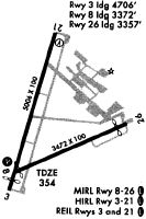
Runways
Runway Summary
| Runways: | 04/22 08/26 |
| Longest Runway: | 04/22 is 5006 ft (1526 m) long |
| Runways with an Instrument Approach: | 04 |
MGJ Airport Runway Details
| Runway 04/22 | 5006 ft x 100 ft (1526 m x 30 m) | |
| Runway Length Source: | 3RD PARTY SURVEY as of 06/30/2020 | |
| Surface: | Asphalt - Excellent condition - Saw-cut or plastic grooved | |
| Runway Edge Lights: | High Intensity | |
Runway Weight Bearing Capacity (in thousands of pounds) |
||
| Single Wheel Landing Gear: | 30.0 | |
| Dual Wheel Landing Gear: | 57.0 | |
| Dual Tandem Wheel Landing Gear: | 85.0 | |
Runway 04 |
Runway 22 |
|
Elevation: |
355.0 | 369.9 |
Latitude: |
41-30-28.9385N | 41-31-14.7224N |
Longitude: |
074-16-05.4048W | 074-15-40.5146W |
|
Runway True Alignment: |
022 | 202 |
ILS Type: |
ILS | |
Glide Path Angle: |
3.0 degrees | 3.0 degrees |
Traffic Pattern: |
Left | Right |
Runway Markings Type: |
Precision Instrument | Precision Instrument |
Runway Markings Condition: |
Good | Good |
Object at End: |
TREES | TREES |
Object Height: |
54 | 65 |
Distance from End: |
555 | 1272 |
Object Centerline Offset: |
489 ft. left of centerline | 523 ft. right of centerline |
Visual Glide Slope Indicators: |
4-Light PAPI On Left Side Of Runway | 2-Light PAPI On Left Side Of Runway |
REIL: |
Yes | Yes |
Touchdown Lights: |
No | No |
Centerline Lights: |
No | No |
Threshold Crossing Height: |
52 | 45 |
| Runway 08/26 | 3664 ft x 100 ft (1117 m x 30 m) | |
| Runway Length Source: | 3RD PARTY SURVEY as of 06/30/2020 | |
| Surface: | Asphalt - Excellent condition - No special surface treatment | |
| Runway Edge Lights: | Medium Intensity | |
Runway Weight Bearing Capacity (in thousands of pounds) |
||
| Single Wheel Landing Gear: | 30.0 | |
| Dual Wheel Landing Gear: | 57.0 | |
| Dual Tandem Wheel Landing Gear: | 85.0 | |
Runway 08 |
Runway 26 |
|
Elevation: |
352.0 | 364.1 |
Latitude: |
41-30-22.5086N | 41-30-37.0993N |
Longitude: |
074-16-05.0127W | 074-15-20.9400W |
|
Runway True Alignment: |
066 | 246 |
Glide Path Angle: |
3.5 degrees | 3.5 degrees |
Traffic Pattern: |
Left | Right |
Runway Markings Type: |
Nonprecision Instrument | Precision Instrument |
Runway Markings Condition: |
Good | Good |
Object at End: |
TREES | FENCE |
Object Height: |
69 | 15 |
Distance from End: |
1788 | 200 |
Object Centerline Offset: |
489 ft. left of centerline | 523 ft. right of centerline |
Visual Glide Slope Indicators: |
2-Light PAPI On Left Side Of Runway | 2-Light PAPI On Left Side Of Runway |
Touchdown Lights: |
No | No |
Centerline Lights: |
No | No |
Threshold Crossing Height: |
49 | 43 |
Threshold Elevation: |
360.8 | |
Displaced Threshold: |
315 | |
Threshold Latitude: |
41-30-35.8448N | |
Threshold Longitude: |
074-15-24.7298W |
Services
Airframe Repair: |
Major |
Powerplant Repair: |
Major |
Bottled Oxygen: |
None |
Bulk Oxygen: |
Low Pressure |
Fuel Available: |
100LL |
Landing Fees: |
No |
Parking: |
Tiedowns available |
Maps & Diagrams
MGJ Sectional
Flight Planning
at skyvector.com
at skyvector.com